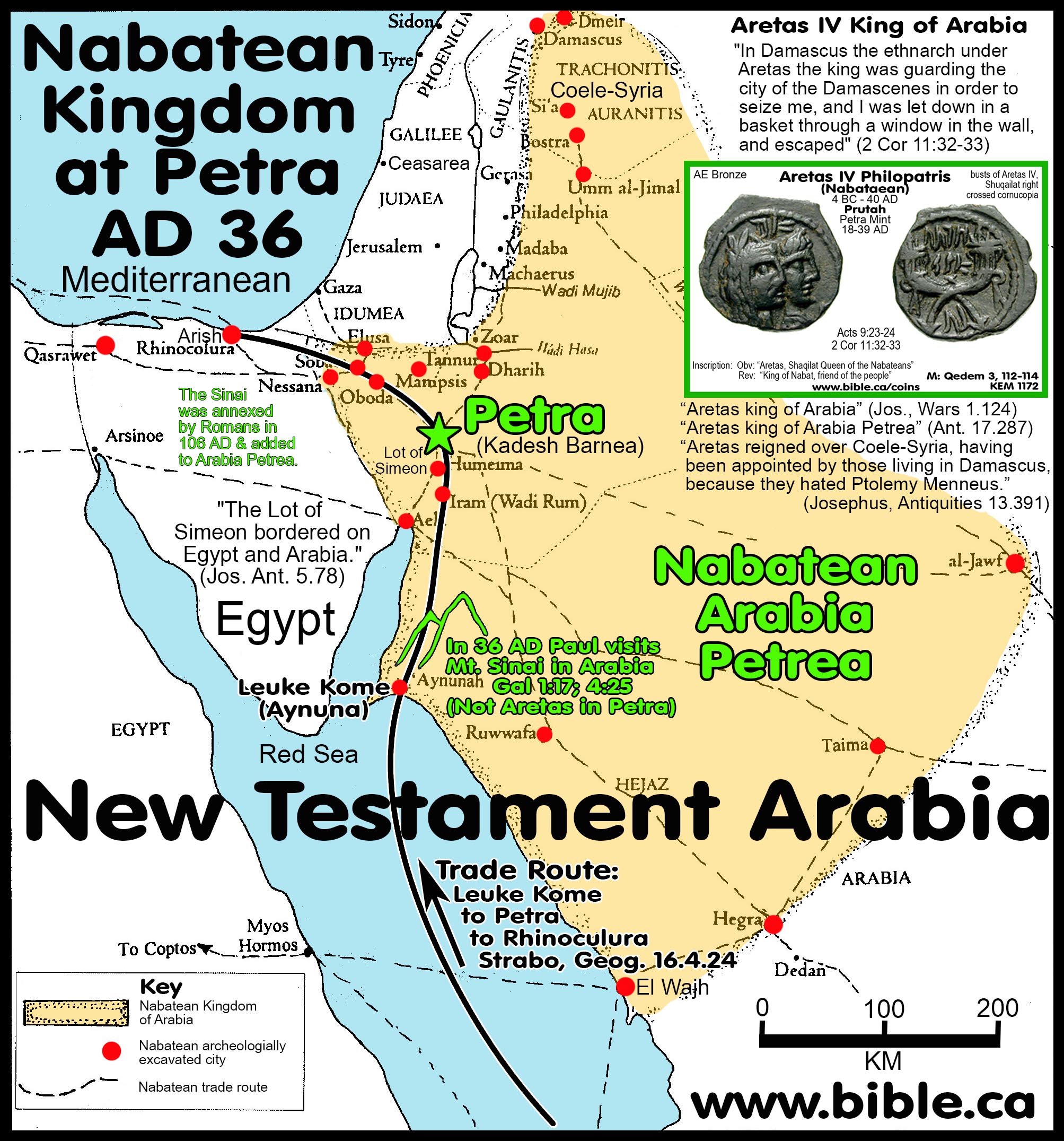
Arabia in the New Testament: AD 36
The Sinai Peninsula was not Arabia and Mt. Sinai was in Arabia Felix
Ishmael lived in Arabia Felix which never included the Sinai Peninsula, therefore Mt. Sinai was in Saudi Arabia.
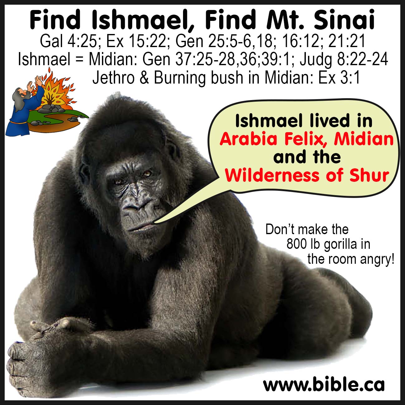
Gal 4:25: Find Ishmael, find Mt. Sinai. Ishmael lived in Midian.
|
Josephus calls the Sinai Peninsula "Egypt".
Josephus never calls the Sinai Peninsula "Arabia".
Hagar and Ishmael lived in Arabia Felix which never included the Sinai Peninsula therefore Mt. Sinai was in Saudi Arabia. |
|
Introduction:
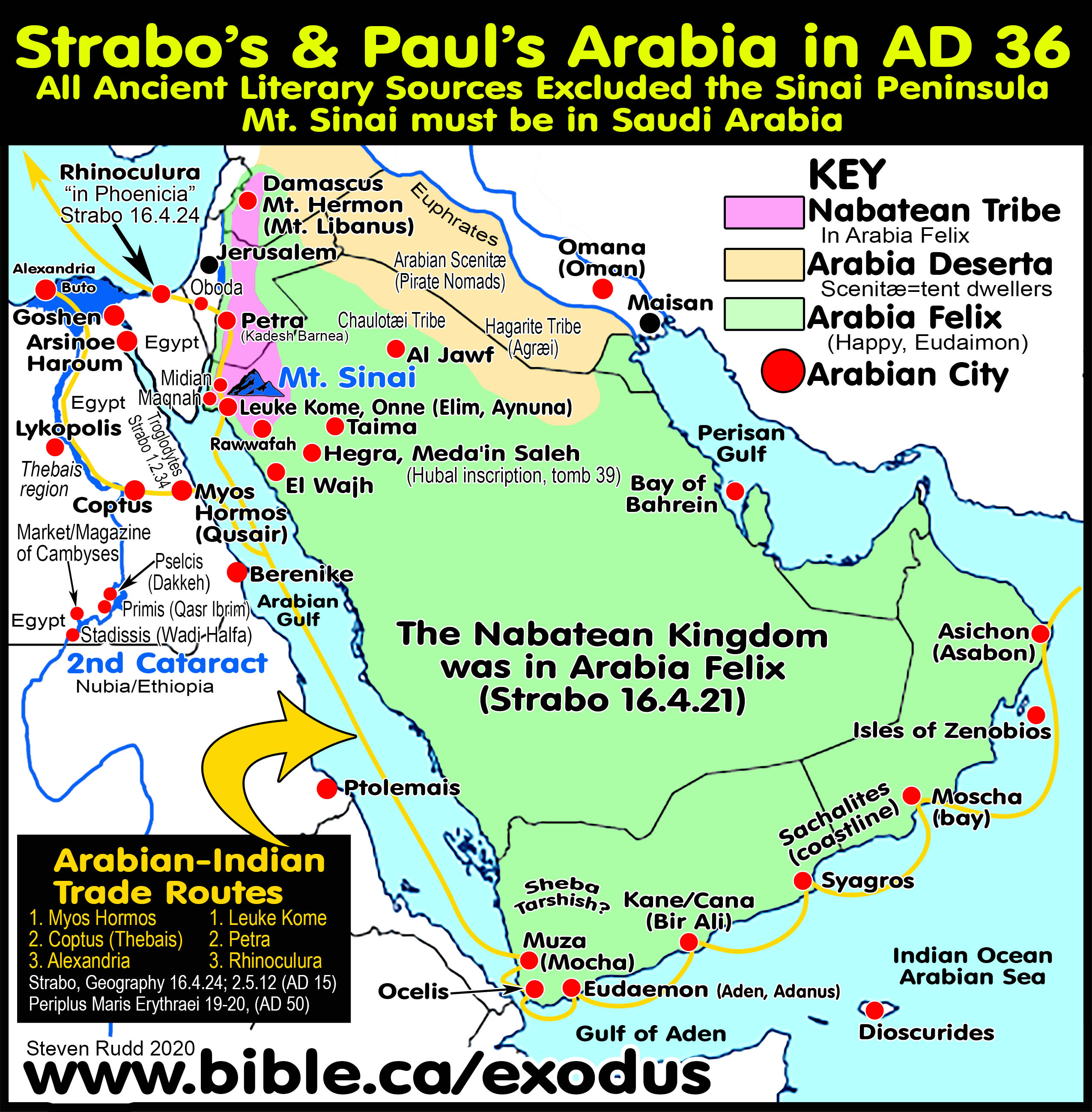
1. Two territories of first century Arabia at the time of Paul’s conversion in AD 36:
a. Arabia in the first century was composed of only two Transjordan territories, not three.
b. Arabia Felix, in which many Arab nations lived, including the Nabatean kingdom. Nabatea was a geographic area inside Arabia Felix, not distinct from it. The Nabatean kingdom was entirely Transjordan with a capital city at Petra. It extended north to Damascus and south to Leuke Kome (Midian) at the Straits of Tiran. At no point in history did Arabia Felix ever include the Sinai Peninsula.
c. Arabia Deserta was the sand deserts of the eastern Arabian Peninsula.
- Trajan created three Roman provinces in AD 106:
- "It was not until 106 AD that the Romans officially annexed Nabatea and the ‘area around Petra’ (Millar, Roman Near East, 94). Eventually, Rome extended their territory as far as Meda’in Saleh—300 miles south of Petra. Rome designated three sub-regions within Arabia: Arabia Petraea (Sinai and the old territory of Nabatea), Arabia Felix (the southwestern coast of the Arabian Peninsula), and Arabia Deserta (roughly the rest of Arabia). The Romans would control Arabia until the rise of the Islamic Arabian Empires of the seventh century." (Lexham Bible Dictionary, Arabia, 2016 AD)
- “Arabia (IX) = Provincia Arabia—mostly Arabia Petraea and part of Arabia Ereme/Deserta: “This nomenclature was introduced in the immediate aftermath of Trajan’s annexation of Arabia Petraea in the year AD 106. Roughly approximating what had been the Nabatean kingdom (= Arabia of the Nabateans; Strabo, Geography 17.1.21), Provincia Arabia in the north was bounded by Syria and the southern Hauran; it extended east into Arabia Ereme/Deserta; on the west it was bounded by Judea (Syria-Palaestina after ad 135), and the new province also took in the southern end of the Dead Sea, southern Transjordan as far as Aila/Aqaba, the Negev, and most of Sinai. This overall provincial outline was modified somewhat in the third century AD, and by the middle of the fourth century, part of Provincia Arabia had become known as Arabia Nea.” (The Meaning of “Arabia” in Classical Literature and the New Testament, Lexham Geographic Commentary on Acts through Revelation, Gal 1:17, p531, 2019 AD)
- The three Roman provinces after AD 106:
- Arabia Petra: The Sinai Peninsula was added to the previous territory of the Nabatean Kingdom, but Midian was removed.
- Arabia Felix: Transjordan area continued to include Midian, but the Nabatean Kingdom was removed.
- Arabia Deserta: The desert areas remained the same before and after.
- Arabia in the mind of Apostle Paul in AD 36 did not include the Sinai Peninsula:
- There is universal agreement that Arabia in the Old Testament was exclusively Transjordan in the Arabian Peninsula.
- All ancient literary sources before AD 77 exclude the Sinai Peninsula as Arabia.
- Apostle Paul was an antitype of Moses with 26 similarities. One was both Lawgivers visited Mt. Sinai in Arabia located in Saudi Arabia at Mt. Lawz in Arabia Felix where Hagar lived (Gal 4:25).
- Strabo describes two of the Arabian trade routes in 16.4.24. The Nabateans were spice traders from southern Arabia, Africa and from India to Egypt, Greece, Rome and Alexandria.
- For Greece and Rome: Leuke Kome to Petra to Rhinocolura.
- For Egypt: Myos Hormos to Coptus (region of Thebais near Thebes) to Alexandria.
- These trade routes went extinct about AD 50 (Geography 16.2.34; 16.4.21; Josephus Antiquities 13.257-258; Pliny the Elder, Natural History, 6.35.181-182).
4. Arabia in the Old Testament was well defined as being entirely Transjordan which included Midian. Arabia in the Bible was never considered as being in the Sinai Peninsula.
|
The Sinai Peninsula was never considered to be Arabia |
||
|
Saudi Arabia |
Sinai Peninsula |
|
|
Arabia had many kings: |
Yes |
No |
|
Paid Tax to Solomon: |
Yes |
No |
|
Silver and gold mines: |
Yes |
No (copper, turquoise) |
|
Arabia is where Hagar and Ishmael lived: |
Yes |
No |
|
Arabia is where Kedar, Tema and Dedan lived: |
Yes |
No |
|
Arabs bordered the Ethiopians: |
Yes |
No |
a. “that from the traders and the wares of the merchants and all the kings of the Arabs and the governors of the country. " 1 Kings 10:15
b. "besides that which the traders and merchants brought; and all the kings of Arabia and the governors of the country brought gold and silver to Solomon." 2 Chronicles 9:14
c. "The oracle about Arabia. In the thickets of Arabia you must spend the night, O caravans of Dedanites. " Isaiah 21:13
d. "Dedan, Tema, Buz and all who cut the corners of their hair, and all the kings of Arabia and all the kings of the foreign people who dwell in the desert." Jeremiah 25:23-24
e. "Dedan traded with you in saddlecloths for riding. Arabia and all the princes of Kedar, they were your customers for lambs, rams and goats; for these they were your customers. " Ezekiel 27:21
f. "Then the Lord stirred up against Jehoram the spirit of the Philistines and the Arabs who bordered the Ethiopians." 2 Chronicles 21:16
I. Find Ishmael, find Mt. Sinai:
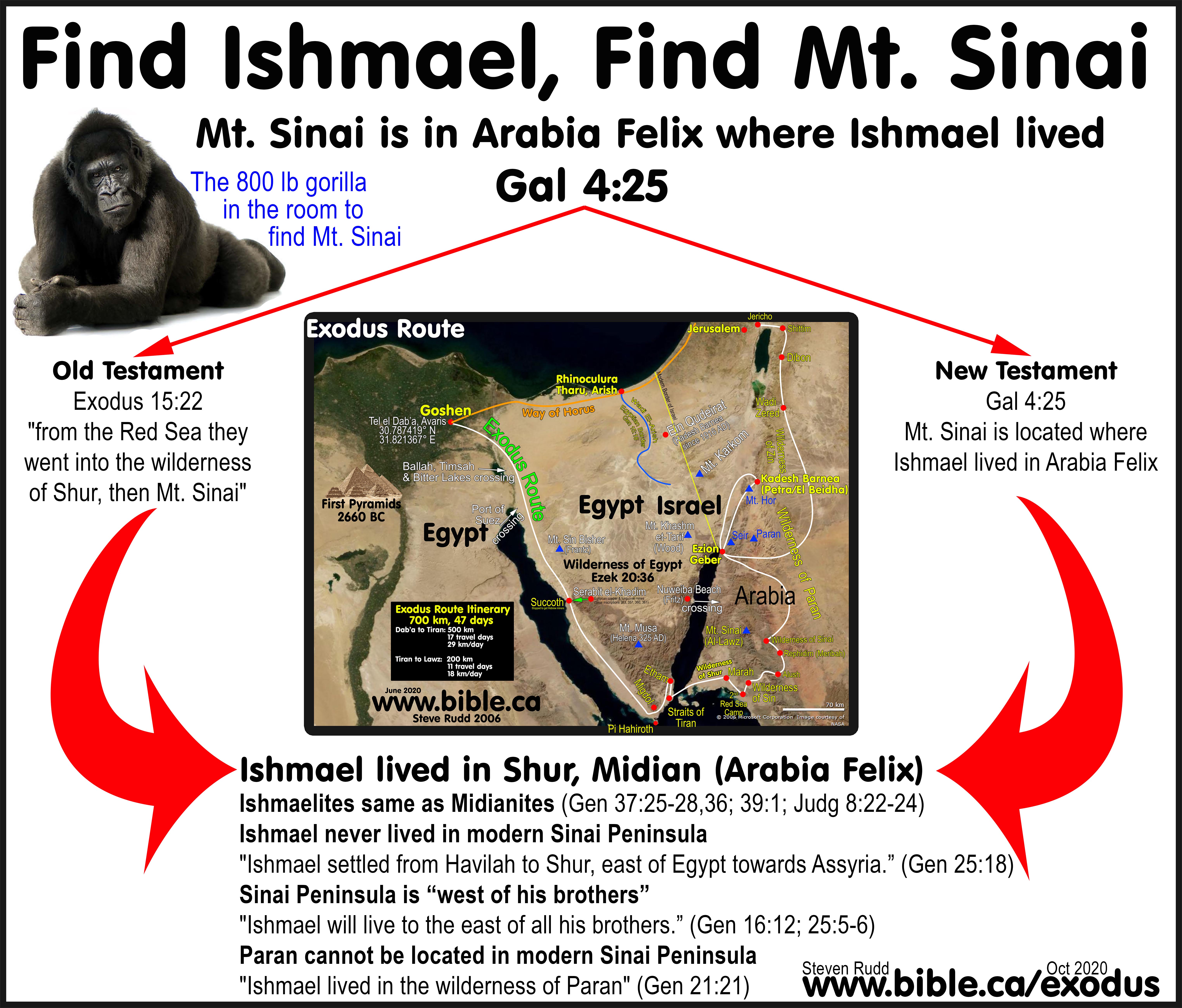
1. Gal 4:25 says that Mt. Sinai is in Arabia, where Ishmael lived.
a. "Now Abraham gave all that he had to Isaac; but to the sons of his concubines [Hagar and Ketura], Abraham gave gifts while he was still living, and sent them away from his son Isaac eastward, to the land of the east." Genesis 25:5–6
b. "Ishmael will be a wild donkey of a man, His hand will be against everyone, and everyone's hand will be against him; And he will live to the east of all his brothers." Genesis 16:12
c. "Ishmael lived in the Wilderness of Paran, and his mother took a wife for him from the land of Egypt." Genesis 21:21
d. "Ishmaelites settled from Havilah to Shur which is east of Egypt as one goes toward Assyria; he [Ishmael] settled in defiance of all his relatives." Genesis 25:18
e. The Ishmaelites are grouped with other Transjordan tribes: "The tents of Edom and the Ishmaelites, Moab and the Hagrites; Gebal and Ammon and Amalek" Psalm 83:6
2. Interchangeably of Ishmaelites and Midianites: Scripture demonstrates that the Ishmaelites and the Midianites had intermarried. They became one tribe at Midian in the Wilderness of Shur because of how both tribes are used interchangeably in the narration of the story of Joseph being sold to the “Midianites/Ishmaelites”. Gen 37:27-28,36; 39:1; Judges 8:22-24
3. Arabia is associated with Kedar. Kedar is called "men of the east" Jer 49:28.
a. Kedar was the son of Ishmael, who intermarried with the Midianites and lived south-east of the Dead Sea. "These are their genealogies: the firstborn of Ishmael was Nebaioth, then Kedar." 1 Chronicles 1:29
b. Ishmael settled in Shur and the wilderness of Paran. Gen 16:12; 21:21; 25:18
c. Ezek 27:21 clearly shows that Arabia meant Saudi Arabia: "Arabia and all the princes of Kedar".
d. Isaiah describes Arabia as including Kedar (Ishmael's son): "The oracle about Arabia. In the thickets of Arabia you must spend the night, O caravans of Dedanites. ... all the splendor of Kedar will terminate." Isaiah 21:13, 16
e. In describing the swath of land from Babylon (Hazor) to Saudi Arabia (Kedar) Jeremiah 49:28 tells Hazor (Babylon) to invade Kedar (Saudi Arabia) calling them "men of the east". "Concerning Kedar and the kingdoms of Hazor, which Nebuchadnezzar king of Babylon defeated. Thus says the Lord, "Arise, go up to Kedar And devastate the men of the east. " Jeremiah 49:28
4. Arabia in the Bible is always — without exception — the land of Midian. (Modern Saudi Arabia).
a. Therefore Arabia = Ishmaelites, Midianites, Kedarites, Wildernesses of Shur and Paran, Midian
b. The Ishmaelites, Midianites, Kedarites never lived west of the Arabah valley in the Negev or the Sinai.
5. Mt. Sinai is in Saudi Arabia and cannot be in the Sinai Peninsula.
a. East of “his brothers” (Isaac in Canaan) was Saudi Arabia.
b. Ishmael lived in the Wilderness of Shur in Midian in Saudi Arabia.
c. The Sinai Peninsula was south of Canaan.
d. Midian is in Saudi Arabia not the Sinai Peninsula.
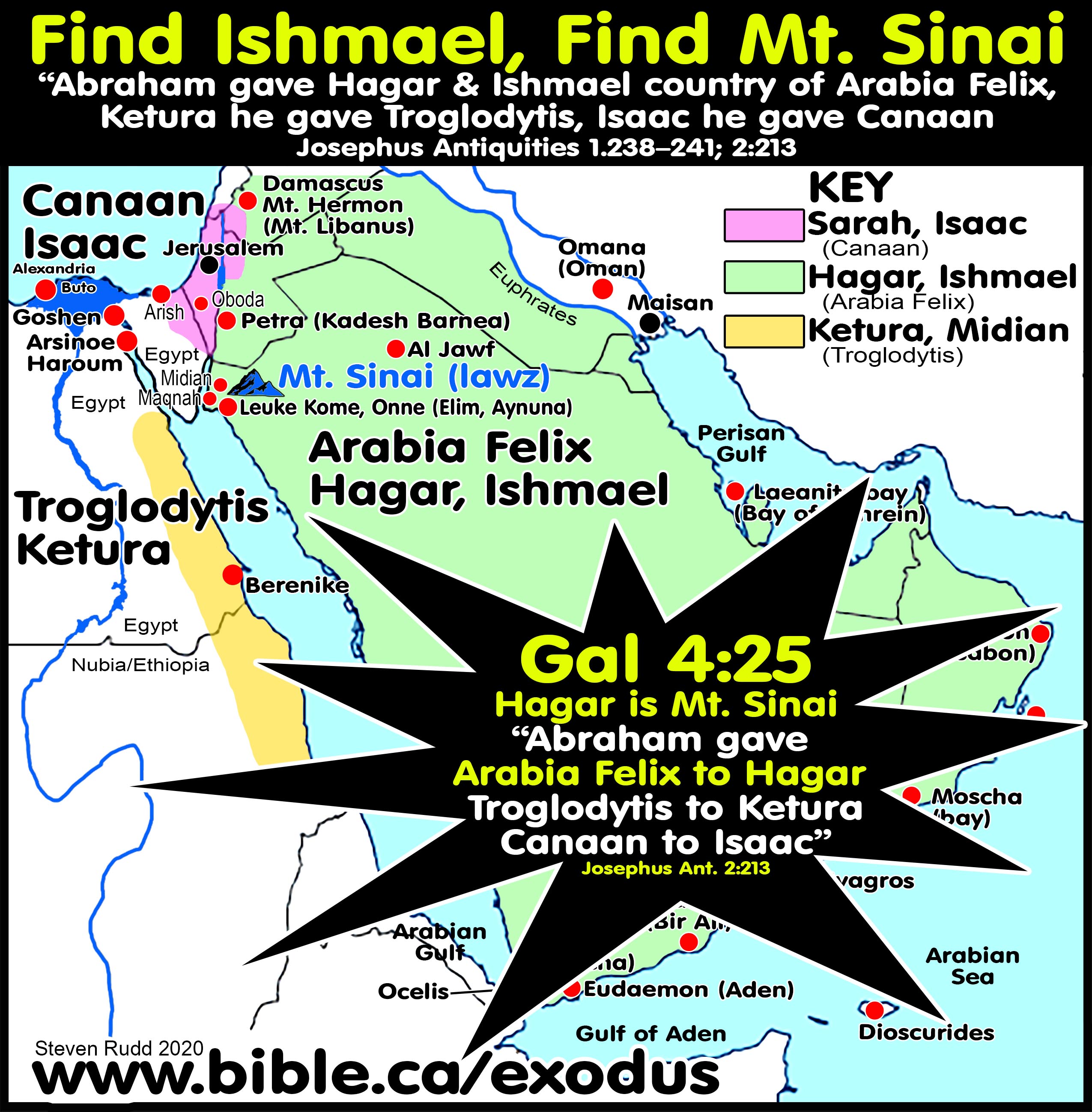
6. Josephus defines Arabia Felix (Happy) as where Hagar and Ishmael lived and where Mt. Sinai is located:
a. “That he [Abraham] left to Ishmael and to his posterity the country of Arabia [Felix - Antiquities 1.239]; as also to his sons by Ketura, Troglodytis: and to Isaac, Canaan.” (Josephus Antiquities 2.213)
b. Abraham’s children through Ketura and Hagar took possession of Troglodytis, and the country of Arabia the Happy, as far as it reaches to the Red Sea.” (Josephus Antiquities 1.238–239)
c. Moses was in the country of the Troglodytes at Midian in 1486 BC when he married Jethro’s daughter. (Josephus Antiquities 2.257–260)
7. Find Hagar and Ishmael — Find Mt. Sinai.
a. Scripture says that Ismael settled in the Wilderness of Shur which is in Midian.
b. According to Josephus, at the time of Abraham, Ketura’s son Midian settled in Troglodytis, which was universally defined by other ancient geographers. The western shoreline of the Arabian gulf in Egypt and Ethiopia.
c. Each of the three distinct geographic areas outlined by Josephus correspond to each of one of Abraham’s three wives.
d. From this we can be certain that the sons of Hagar at Mt. Sinai are in Arabia Felix.
8. Following Midian:
a. Josephus tells us that originally, Ketura’s sons, including Midian, had settled in Troglodytis and Hagar’s sons including Ishmael, had settled from “Havalia to Shur” [Wilderness of Shur] in Arabia Felix.
b. Scripture tells us that in 1899 BC Joseph was sold to the Midianites/Ishmaelites, who had become one tribe (likely through intermarriage).
c. Josephus tells us that Moses in 1486 BC fled to Midian which Josephus describes as the country of the Troglodytes (Josephus Ant. 2.257–260).
d. Josephus is the only ancient geographer to say that Midian at the Wilderness of Shur was the land of Troglodytis. Josephus understood that originally, all the sons of Ketura had located near the Egyptian, Ethiopian border on the opposite side of Arabia Felix but later, Midian moved back across the Arabian Gulf to join tribes with Ishmael in Shur near Al Bad.
9. Josephus identifies three distinct geographic areas (Canaan, Arabia Felix, Troglodytis) and marks Mt. Sinai to be in Arabia Felix, which at the time of Paul, included all of Saudi Arabia south of the Gulf of Aqaba including Midian.
II. History of the Arabian Nation: Ishmael to Islam
- Arabs descended directly from Ishmaelites and Midianites.
- Nabateans were Ishmaelites, not Edomites. The Ishmaelite ancient territory was Transjordan from the Persian Gulf in Iran to the Arabian Gulf (Red Sea) and the Gulf of Aqaba (Red Sea). Midian (Al Bad) was located inside the Wilderness of Shur at the time of the Exodus in north-western Saudi Arabia.
- Ishmaelites like the Nabateans were nomadic traders as seen in the story of Joseph being sold to the Caravan at Dothan in Canaan.
- The Edomites went extinct around 550 BC and the Ishmaelites living in traditional ancient Arabia moved north and east from Midian to the ancient site of Kadesh Barnea at Petra.
- Petra was an excellent choice as the location of their capital city since it lies at the major crossroad of three caravan roads that feed southern Arabia, Babylon, Israel, and Egypt.
- Leuke Kome was the port of Petra. Goods were shipped from Arabia and India to Leuke Kome by ship where they were offloaded onto camel caravans to Petra then to Rhinocolura.
- During the first century BC, the Nabateans established a collection of cities in the Judean Negev as a midpoint between Petra and Rhinocolura for the spice trade route.
- Around AD 25, the Romans learned to use the Monsoon winds to successfully sail directly by sea to India and back. This decimated the Nabatean economy.
- In AD 50 the Nabatean cities of the Negev were destroyed, and the Nabatean kingdom collapsed.
- The Nabatean kingdom was conquered by Trajan in AD 106.
- "After his death Obodas [king of Arabia] was buried at Oboda, the town named after him. Obodas was deified and—as evidenced by Nabatean and Greek inscriptions—his cult persisted at Oboda until the 3rd century ad. Without waiting for Augustus’ confirmation Aretas IV (9 BC–AD 40), son of Obodas, ascended the throne. In his coins and inscriptions he is known by the title ‘he who loved his people’. During his reign the kingdom reached its highest point, both economically and in its architecture, sculpture, painting and pottery. Except for the dispatch by Aretas of a military force to quell some riots in Judea after Herod’s death in 4 BC (Josephus, Antiq. xvii, 287), and a mention of him as ruler of Damascus in AD 39 (2 Cor. 11:32), there is little about him in the ancient sources. On the other hand an exceedingly large number of inscriptions, dated by the years for which Aretas IV had reigned, have been found in every quarter of the kingdom, from northern Arabia in the south to southern Syria in the north, and to Oboda and Sobata in the west. These testify to the great expansion of the kingdom. The decline set in during the reign of Malichus II (AD 40–70), the first-born son of Aretas IV. First the Nabateans lost Damascus. In AD 67 Malichus sent an army to help Vespasian in the siege of Jerusalem (Josephus, War iii, 68). Otherwise he is little mentioned. It was in his time that the Romans learned to make use of the southwest monsoon. Earlier in the 1st century AD Hippalus had discovered that the monsoon made it possible to sail safely to India and back and they were therefore able to bring spices and aromatics directly from India to Alexandria and thence to Rome, dealing a mortal blow to the Nabatean economy. In about AD 50 it seems to have suffered another blow. New tribes migrated from Arabia to the southern parts of the kingdom and penetrated the Negev, where they destroyed Oboda and the forts on the Petra-Gaza road." (The Archaeological Encyclopedia of the Holy Land, Nabateans, 1986 AD)
- Echoing the Edomites who burned the temple of Solomon in 587 BC, the Nabateans under King Malchus of Arabia (same territory as the Edomites) assisted Titus in attacking Jerusalem in AD 67.
- Edomites burned Solomon's temple at the hands of the Babylonians. Nebuzaradan wanted to burn the temple of Solomon and the Edomites volunteered to light the match as delegated agents of destruction:
- "You [Cyrus] also vowed to rebuild the temple which the Edomites set on fire when Judah was devastated by the Chaldeans." (1 Esdras 4:45)
- "Now on the tenth day of the fifth month, which was the nineteenth year of King Nebuchadnezzar, king of Babylon, Nebuzaradan the captain of the bodyguard, who was in the service of the king of Babylon, came to Jerusalem. He burned the house of the Lord, the king’s house and all the houses of Jerusalem; even every large house he burned with fire." (Jeremiah 52:12–13)
- Nabateans assisted Titus in 67 AD: "But as to Titus, he sailed over from Achaia to Alexandria, and that sooner than the winter season did usually permit; so he took with him those forces he was sent for, and marching with great expedition, he came suddenly to Ptolemais, (65) and there finding his father, together with the two legions, the fifth and tenth, which were the most eminent legions of all, he joined them to that fifteenth legion which was with his father: (66) eighteen cohorts followed these legions; there came also five cohorts from Caesarea, with one troop of horsemen, and five other troops of horsemen from Syria. (67) Now these ten cohorts had severally a thousand footmen, but the other thirteen cohorts had no more than six hundred footmen apiece, with a hundred and twenty horsemen. (68) There were also a considerable number of auxiliaries got together, that came from the kings Antiochus, and Agrippa, and Sohemus, each of them contributing one thousand footmen that were archers, and a thousand horsemen. Malchus also, the king of Arabia, sent a thousand horsemen, besides five thousand footmen, the greatest part of whom were archers; (69) so that the whole army, including the auxiliaries sent by the kings, as well horsemen as footmen, when all were united together, amounted to sixty thousand, besides the servants, who, as they followed in vast numbers, so because they had been trained up in war with the rest, ought not to be distinguished from the fighting men; for as they were in their masters’ service in times of peace; so did they undergo the like dangers with them in times of war, insomuch that they were inferior to none, either in skill or in strength, only they were subject to their masters." (Josephus, Wars 3:64-69)
- In 106 AD, Trajan created the new province of Arabia Petra when he annexed the Sinai Peninsula from Egypt and added it to the territory of the Nabatean kingdom.
- After the destruction of the temple in AD 70, Pliny the Elder notes that in AD 77, Arabs had moved into the Sinai Peninsula.
- Before this point in history the Sinai Peninsula had never been considered Arabia.
- Trajan simply formalized the reality of Arabs living in the Sinai by creating Arabia Petra.
- Muhammed, the founder of Islam in AD 610, was of this Ishmaelite/Nabatean tradition.
- In one generation, the Muslims accomplished a mass conversion of language, culture and religion in the entire middle east bringing almost complete extinction to Christianity.
- The Ishmaelites governed at Petra for 300 years until AD 106, with a pause till the rise of the Islam around AD 600.
- The Muslim conquering of the world in AD 600 plunged the world into the period of the Dark ages for 1000 years until the Renaissance. The final defeat of the Ishmaelites was accomplished in 1916 AD with the collapse of the Ottoman empire. Islam today is the ancient Arabian Nabatean Kingdom in a different form headed at Mecca not Petra.
- Several ancient sources describe how the Arabs were untamable and undefeatable in the Arabian Peninsula. Many warring and competing Arabian nations continued from before the first century until the time of Muhammed, who for purely economic reasons, invented the 30 days of Ramadan, that outlawed tribal fighting and facilitated peaceful trading. Muhammed transformed the long tradition of divided Arab tribal pagan polytheism into a unified political califate that espoused pagan monotheism. The Hajj is a collection of Arab pagan polytheistic rituals redefined as monotheistic rituals. Islam itself is a combination of 1/3 Old Testament, 1/3 New Testament and 1/3 traditional first century Arabian pagan polytheism.
d.
The Chronicle of Theophanes was a yearly diary of events from the 3rd
to 9th century AD and was written in 813 AD. For the diary of world
events in AD 629, Theophanes calls Muhammed the Arab “leader
and false prophet of the Saracens … descendant of Ishmael” and the Arabs
who populated the new Islamic religion as Ishmaelites.
The Chronicle of Theophanes confirms the Bible in that Saudi Arabia was the
homeland of Ishmael. The Chronicle of Theophanes confirms the Bible that the
“Wilderness of Shur” and the land of “Shur” were in North West Saudi Arabia
opposite the Straits of Tiran.
Chronicle of Theophanes in AD 629:
"Muhammad [Mouamed], leader of the Arabs (9 years), [9th year Sergius,
bishop of Constantinople (29 years), 22nd year Zacharias, bishop of Jerusalem
(22 years), 22nd year George, bishop of Alexandria (14 years), 12th year.] In
this year died Mouamed [i.e. Muhammed, founder of Islam], the leader and false prophet of the Saracens, after
appointing his kinsman Abu Bakr [Aboubacharos] to his
chieftainship. At the same time, his repute spread abroad and everyone was
frightened. At the beginning of his advent the
misguided Jews thought he was the Messiah who is awaited by them, so that
some of their leaders joined him and accepted his religion while forsaking that
of Moses, who saw God. Those who did so were ten in number, and they remained
with him until his murder. But when they saw him eating camel meat, they
realized that he was not the one they thought him to be, and were at a loss
what to do; being afraid to abjure his religion, those wretched men taught him
illicit things directed against us, Christians, and remained with him. I consider
it necessary to give an account of this man's [Muhammad] origin. He was descended from a very widespread tribe, that of
Ishmael, son of Abraham; for Nizaros, descendant of Ishmael, is recognized as
the father of them all. He begot two sons, Moudaros and Rabias. Moudaros
begot Kourasos, Kaisos, Themimes, Asados, and others unknown. All of them dwelt
in the Midianite desert and kept cattle, themselves living in tents. There are
also those farther away who are not of their tribe, but of that of Lektan, the
so-called Amanites, that is Homerites. And some of them traded on their camels.
Being destitute and an orphan, the aforesaid Mouamed decided to enter the
service of a rich woman who was a relative of his, called Chadiga, as a hired
worker with a view to trading by camel in Egypt and Palestine. Little by little
he became bolder and ingratiated himself with that woman, who was a widow, took
her as a wife, and gained possession of her camels and her substance. Whenever he came to Palestine he consorted with Jews and
Christians and sought from them certain scriptural matters. He was also afflicted with epilepsy. When his wife became aware of
this, she was greatly distressed, inasmuch as she, a noblewoman, had married a
man such as he, who was not only poor, but also an epileptic. He tried deceitfully to placate her by saying, 'I keep seeing
a vision of a certain angel called Gabriel, and being unable to bear his sight,
I faint and fall down.' Now, she had a certain monk [named one of these:
Sergius, Bahira, Nastur] living there, a friend of hers (who had been exiled
for his depraved doctrine), and she related everything to him, including the
angel's name. Wishing to satisfy her, he said to her, 'He has spoken the
truth, for this is the angel who is sent to all the prophets.' When she had
heard the words of the Aboubacharos, whom he left false monk, she was the first
to believe in Mouamed [Muhammad] and proclaimed to other women of her tribe
that he was a prophet. Thus, the report spread from women to men, and first to
[Abu Bakr, 1st Muslim Caliph] Aboubacharos, whom he left as his
successor. This heresy prevailed in the region of Ethribos, in the last resort
by war: at first secretly, for ten years, and by war another ten, and openly
nine. He taught his subjects that he who kills an enemy or is killed by an
enemy goes to Paradise; and he said that this paradise was one of carnal eating
and drinking and intercourse with women, and had a river of wine, honey, and
milk, and that the women were not like the ones down here, but different ones,
and that the intercourse was long-lasting and the pleasure continuous; and
other things full of profligacy and stupidity; also that men should feel
sympathy for one another and help those who are wronged." (Chronicle 629
AD of Theophanes, 813 AD)
- Mt. Sinai and Arabia Ishmaelite crescent Moon worship:
- “Wilderness of Sin” means “Wilderness of the moon god”. Mt. Sinai was a major center of moon worship, despite the fact it was also the holy Mountain of God.
- The Arabians have always worshipped the moon god from the time of Ishmael down to Muhammed at Mecca.
- "Then Zebah and Zalmunna said, “Rise up yourself, and fall on us; for as the man, so is his strength.” So Gideon arose and killed Zebah and Zalmunna, and took the crescent [moon] ornaments which were on their camels’ necks." (Judges 8:21)
- "The weight of the gold earrings that he requested was 1,700 shekels of gold, besides the crescent [moon] ornaments and the pendants and the purple robes which were on the kings of Midian, and besides the neck bands that were on their camels’ necks." (Judges 8:26)
- Hubal Moon god was the top Arabian god in Mecca:
- Historically, Hubal was the supreme pagan god of the 360 gods inside the Kabah at Mecca. Illiterate Muhammad initially worshipped before his epiphany towards pagan monotheism when Gabriel supposedly told him Christianity was a false religion in AD 610, and to start the one true religion on his own. The illiterate Joseph Smith patterned the origins of Mormonism in exactly the same way after a supposed visit from the angel Moroni in AD 1823.
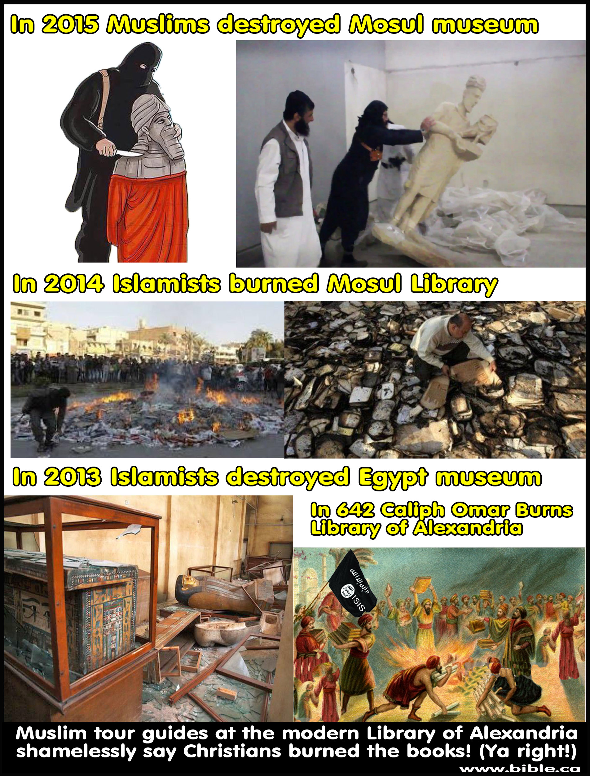
- Part of the problem connecting Hubal to Moon worship is
the extremely low literacy rate among Arabians from the first century
down to as late as AD 758 and the scarcity of extant early Arabian
literary sources. Just as Islamic leaders destroyed all the variant
copies of the Koran that existed in the 8th century, they also
destroyed historic literary sources. The Library at Alexandria was burned
by Calif Omar in AD 642. Recently Muslims continue their quest to erase
history with the burning and destruction of museums and archaeological
sites. The very few Arabians that may have recorded a pre-Islamic history
connecting Hubal with Moon worship, would have had their books burned by
the Caliphate. Early Muslims burned variant copies of the Koran to create
the fiction of the “perfect Koran”. All this to create a new fiction that
Islam dated back to Adam and Eve at creation.
- While Muhammad formally disavowed moon worship, he redefined Hubal the Moon God as the one monotheistic pagan god, “Allah”. Akhenaten did exactly the same thing with his Egyptian monotheistic Sun worship in 1358 BC, two years before monotheistic Joshua died after conquering Canaan.
- Muhammad himself, who authored the Koran, was illiterate.
After the collapse of Christianity in AD 642, illiterate Arabs put
literate Christians in charge of administrative and business accounting
duties.
Chronicle of Theophanes in AD 758:
“In this year (AD 758) the Arabs maliciously expelled the Christians from government chanceries [treasury records and archives] for a short time, but were once again obliged to entrust the same duties to them because they were unable to write numbers.” (Chronicle 758 AD of Theophanes, 813 AD) - This historic event in AD 758 is particularly amusing given 60 short years later in AD 820. The “Compendious Book” by Muhammad ibn Musa al-Khwarizmi provided one of the greatest advancements in Algebra in the history of Mathematics. Arabs could not write numbers, and suddenly 60 years later they develop advanced mathematical algebra? Could it be that Khwarizmi was illiterate, and Christians were the ghost writers of the landmark book on Algebra, but Khwarizmi took the credit for it? Almost no biographical information is known about Khwarizmi. Christians were slaves and it was the Dark Ages. We may never know for certain who invented modern Algebra.
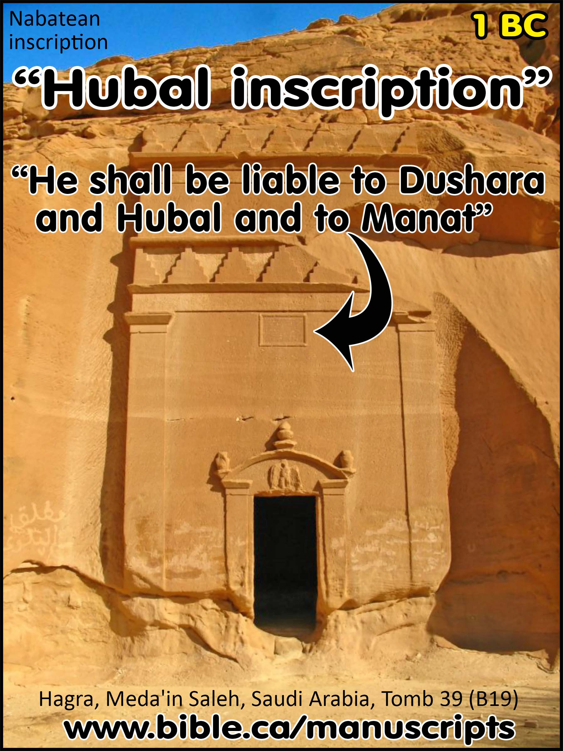
- “Hubal” Nabatean inscription at Hegra from tomb 39 (B19).

- A Nabatean inscription that mentions Hubal, dated to the first century BC at Hegra (Meda'in Saleh) on tomb B19. While the Nabateans were literate, the non-Nabatean Arabians were illiterate.
- “The inscription, dated 1 bce/ce, is the finest of 38 carved on Nabataean tomb facades (this one is tomb no. B 19) at the site of Madāʾin Ṣāliḥ (ancient Ḥegra) in northern Saudi Arabia. The tombs were first described, and the texts copied by C. Doughty in 1883. Subsequent work, especially by J. Euting and Frs A. Jaussen and R. Savignac (Jaussen and Savignac 1909), established the importance of this southern outpost of the Nabataean kingdom in the 1st century ce. The tomb inscriptions, many of which are precisely dated, are particularly informative on religion, social structure, and legal matters. It is clear that the surviving texts were also preserved on papyrus in the legal archives of the city or one of its temples.” (COS, J. F. Healey, Nabataean Inscriptions, Tomb B19, 2.67, p191, 2000 AD)
- “Ownership (lines 1–2a): This is the tomb which Kamkam daughter of Waʾilat daughter of Ḥaramu and Kulaybat, her daughter, made for themselves and their descendants. [It is noteworthy that there are several Nabataean tombs owned by and designed for the use of women.] Date (lines 2b–3a): In the month of Ṭebet, the ninth year of Ḥaretat, King of the Nabataeans, lover of his people. [December/January 1 BCE/CE . Aretas IV (9 BCE - 40 CE) is usually given the nationalistic title “lover of his people.”] Curse (lines 3b–7a): And may Dushara and his throne [Dushara (“the master of the Shara mountains”) was the main Nabataean god. Astral in character, he is elsewhere called “the one who separates day from night” and “lord of the world.” Dushara’s “throne” (mwtb) was the object of separate veneration: see Healey 1993:156–158.] and Allat of ʿAmnad [The divine name Allat is borrowed from Arabic. The apparent geographical name ʿmnd cannot be identified.] and Manotu [Manotu is known from early Islamic evidence as Manāt.] and her Qaysha curse anyone who sells this tomb or who buys it or gives it in pledge or makes a gift of it or removes from it body or limb or who buries in it anyone other than Kamkam and her daughter and their descendants. [The terminology is legalistic and it is reflected in such Nabataean legal papyri as have survived, notably those from the Babatha archive.] Fine (lines 7b–10): And whoever does not act according to what is written above shall be liable to Dushara and Hubalu [Hubal: one of the pre-Islamic deities of Mecca.] and to Manotu in the sum of 5 shamads [The šmd has no obvious cognate. It is most likely that it is some kind of monetary unit, probably a large unit.] and to the exorcist-priest [Nabataean ʾpklʾ. It occurs quite frequently and is also found in Palmyrene and Hatran Aramaic and in Sabaic, Minaean and Lihyanite.] for a fine of a thousand Haretite selaʿs [The Nabataean selaʿ is the normal unit of silver coin (here specified as according to the standard established by the king Ḥaretat). It corresponds to the silver tetradrachm.], except that whoever produces in his hand a document from the hand of Kamkam or Kulaybat, her daughter, regarding this tomb, this document will be valid. The Mason (lines 11–12): Wahballahi son of ʿAbdʿobodat made it.” (Hagra, Meda'in Saleh, Hubal Nabatean inscription, Tomb 39, B19, 1 BC)
- Islamic literary sources document Hubal’s connection with the origins of Islam at the time of Muhammed:
- Hubal was the top Arabian god at the time of Muhammed inside the Kabah at Mecca. He was made from red agate and held 7 divining arrows. On Wednesday, 14th August 591 BC, Ezekiel described how Nebuchadnezzar “shook the arrows” for divination. While there is no direct connection with Hubal of Islam 12 years later, the practice continued in Mecca by Muhammed’s Quraysh tribe in AD 600.
- “For the king of Babylon stands at the parting of the way, at the head of the two ways, to use divination; he shakes the arrows, he consults the household idols, he looks at the liver. “Into his right hand came the divination, ‘Jerusalem,’ to set battering rams, to open the mouth for slaughter, to lift up the voice with a battle cry, to set battering rams against the gates, to cast up ramps, to build a siege wall." (Ezekiel 21:21–22, 591 BC)
- The Islamic record of Ibn al-Kalbi dates to AD 821 and provides clarity that Hubal was in fact the top god among the 360 pagan gods inside the Kabah at the time of Muhammed in AD 610: “The Quraysh had also several idols in and around the Kabah. The greatest of these was Hubal. It was, as I was told, of red agate, in the form of a man with the right hand broken off. It came into the possession of the Quraysh in this condition, and they, therefore, made for it a hand of gold. The first to set it up [for worship] was Khuzaymah ibn Mudrikah ibn al-Ya's ibn Muclar. Consequently, it used to be called Khuzaymah's Hubal. It stood inside the Kabah. In front of it were seven divination arrows. On one of these arrows was written 'pure', and on another `consociated alien'. Whenever the lineage of a new-born was doubted, they would offer a sacrifice to it [Hubal] and then shuffle the arrows and throw them. If the arrows showed the word 'pure', the child would be declared legitimate and the tribe would accept him. If, however, the arrows showed the words `consociated alien', the child would be declared illegitimate and the tribe would reject him. The third arrow was for divination concerning the dead, while the fourth was for divination concerning marriage. The purpose of the three remaining arrows has not been explained. Whenever they disagreed about something, or purposed to embark upon a journey, or undertake some project, they would proceed to it [Hubal] and shuffle the divination arrows before it. Whatever the result they obtained they would follow.” (Ibn al-Kalbi, 821 AD)
- Arabia, therefore, really is the story from Ishmael to Islam or stated more correctly Ishmael is Islam.
- Islam corrupts the truth with a lie that Abraham offered Ishmael on an altar in Mecca instead of Isaac on an altar in Jerusalem.
- Islam is the religion of "bitter-grapes" revenge of being the "cast out fleshly" son Ishmael supplanting Isaac, the true chosen son of promise and miracle from whom Jesus Christ came.
- Such rewriting and erasing of history may comfort Muslims but it is delusion: "with all the deception of wickedness for those who perish, because they did not receive the love of the truth so as to be saved. For this reason God will send upon them a deluding influence so that they will believe what is false, in order that they all may be judged who did not believe the truth, but took pleasure in wickedness." (2 Thessalonians 2:10–12)
- Paul's allegory disconnects the Jews from Abraham and they are adopted in the bloodline of Hagar, the mother of Arabia. Gentile Christians are directly connected to Abraham and Sarah and Christ. Today, Muslims and Jews are both “cast out” as sons of Hagar.
- "Tell me, you who want to be under law, do you not listen to the law? For it is written that Abraham had two sons, one by the bondwoman and one by the free woman. But the son by the bondwoman was born according to the flesh, and the son by the free woman through the promise. This is allegorically speaking, for these women are two covenants: one proceeding from Mount Sinai bearing children who are to be slaves; she is Hagar. Now this Hagar is Mount Sinai in Arabia and corresponds to the present Jerusalem, for she is in slavery with her children. But the Jerusalem above is free; she is our mother. For it is written, “Rejoice, barren woman who does not bear; Break forth and shout, you who are not in labor; For more numerous are the children of the desolate Than of the one who has a husband.” And you brethren, like Isaac, are children of promise. But as at that time he who was born according to the flesh persecuted him who was born according to the Spirit, so it is now also. But what does the Scripture say? “Cast out the bondwoman and her son, For the son of the bondwoman shall not be an heir with the son of the free woman.” So then, brethren, we are not children of a bondwoman, but of the free woman." (Galatians 4:21–31)
- Today Arabian history has come full circle because the crescent moon earrings warn by Arabian Ishmaelites, now sit atop every mosque as the central symbol of Islam, which betrays the true origin of Hubal moon worship which Muhammed transformed into "pagan monotheism".
- Summary of Arabian kingdom history:
- Ishmaelites/Midianites were the ancient Arabian Kingdom at the time of the Exodus in 1446 BC.
- The Nabateans were the most powerful Arabian nation of the many Arab tribes at the time of Christ and the Apostle Paul. King Herod was a force-converted Nabatean Jewish Proselyte
- Islam is Arabia, the sons of Hagar through Ishmael.
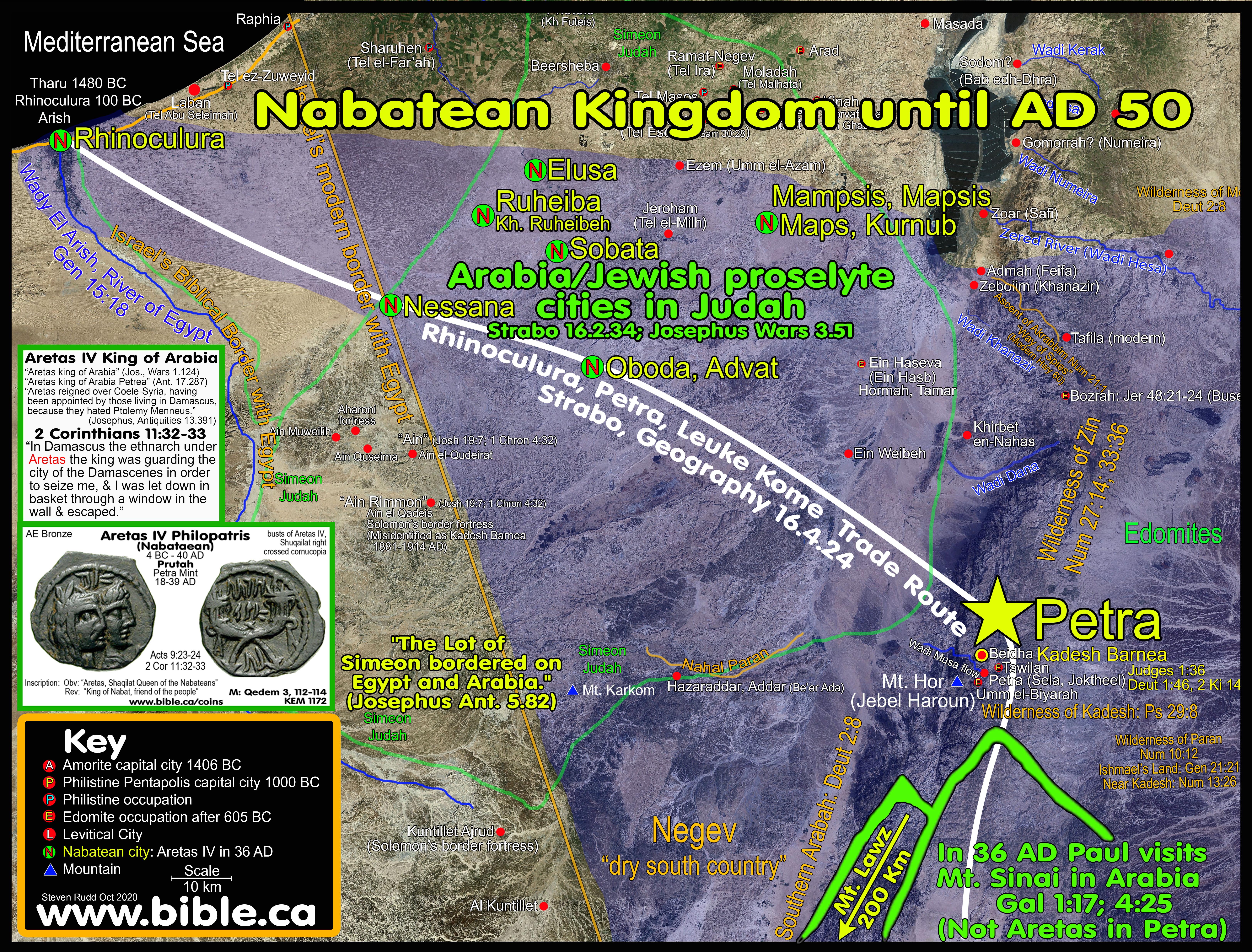
III. Nabatean cities in the Judean Negev in AD 36:
List of Nabatean spice trade towns in the Judean Negev where goods were shipped from Leuke Kome (Elim) to Petra then through these cities. Strabo and Josephus describe the forced conversion of the Nabateans, including Herod the Great by Hyrcanus in 129 BC. (Strabo, Geography 16.2.34; 16.4.21; Josephus Antiquities 13.257-258) The Nabatean cities south of Beersheba were circumcised proselytes. This proves that these Nabatean cities located in the Judean Negev were not part of Arabia or controlled by the King at Petra but were vassal cities under the Maccabeans in Judean territory.
- Elusa
- “The capital of the Negev was the Nabatean city of Elusa or Al-Khalasa; it was plundered already in ancient times to obtain construction materials. Recent excavations, however, have brought to light again a portion of a large basilica, which first had only one apse then three (EAEHL, 359ff.). More fortuitous discoveries in other small towns of the Negev have also brought to light important ruins of churches, two or more in each center, with many inscriptions on mosaic and rock. One should also mention the city of Eboda (or Avdat), in which two churches have been found. At Nitzana, now Haugia el Hafi, were found, in addition to two churches, liturgical and secular MSS, among which was a small Greek-Virgilian dictionary. Also, at Shivta or Sbaita, three churches were found. Mefis, or Kornub, contains three churches. Rehovot, or Betomolachon, contains three churches. Study of the entire complex and comparison of various architectural elements of these sacred buildings has permitted scholars to forward a detailed chronology of the various stylistic-constructive phases of these churches that goes from the 2nd half of the 4th c. to the first years of the 7th (Negev, The Cathedral of Elusa).” (Encyclopedia of Ancient Christianity; G. Bagatti—C. Pappalardo, Palestine, Vol 3, p24, 2014 AD)
- Ptolemy, Geography 5.16.10
- Peutinger map: “On the Peutinger map, Elusa is marked at a distance of 24 Roman miles from Oboda and 71 from Jerusalem, on the way from Haila (=Aila=Elat).” (AYBC, Elusa)
- Libanius Ep. 101, 132, 532, 536
- Medaba map
- Advat, Oboda
- Ptolemy, Geography 5.17.4
- Peutinger map
- Ruheiba, Rehovot, Betomolachon, Rehovot-in-the-Negev, Khirbet Ruheibeh
- “Rehovot, or Betomolachon, contains three churches.” (Negev, The Cathedral of Elusa).” (Encyclopedia of Ancient Christianity; G. Bagatti—C. Pappalardo, Palestine, Vol 3, p24, 2014 AD)
- “Rehovot-in-the-Negev, Khirbet Ruheibeh, Betomolachon: “Site in the Negev, 35 km southwest of Beersheva, on the road between Elusa and Nessana, in southern Israel (see map 22, A7). R. is situated on a broad hill beside a branch of the Incense Road from Petra to Gaza. This branch leaves the main road at Elusa and runs southwest via R. and Nessana into the Sinai; it veers northwest toward El-Arish (ancient Rhinokoroura) and continues into Egypt. The Nabataeans established a small settlement at R., probably no more than a road station, not later than the 1st century a.d. The settlement continued in use during the early Roman period, after the annexation of the Nabataean kingdom to the Roman Empire in 106.” (Eerdmans Encyclopedia of Early Christian Art and Archaeology, Yoram Tsafrir, Rehovot-in-the-Negev, Vol 2, p406, 2017 AD)
- Nessana
- 6th century AD papyri found on site
- “The site [Nessana] is on one of the major ancient caravan routes, leading from Aila on the Red Sea through the western fringes of the Negev to Rhinocorura and Gaza, and over Elusa to Beer-sheba, Hebron, and Jerusalem.” (AYBD, Nessana)
- Sobata
- Mentioned in the Nessana Papyri dating to the 6th century AD.
- “Sobata is never mentioned in ancient sources, and its history may be studied from only archaeological finds and the Nessana papyri. The earliest find on the site is an inscription mentioning Aretas IV (9 BC – AD 40) and pottery of the Middle Nabatean Period. It was probably founded as a road station on the secondary caravan route connecting Oboda with Nessana. It shared the prosperity of the other towns of the Negev in the Late Nabatean Period, and to this period pertains about one third of the development.” (AYBD, Sobata)
- Mampsis, Maps, Mapsis, Kurnub
- Ptolemy, Geography 5.16.10; Onomasticon 8.8
- “Asasan Thamar (Asasonthamar). Where the Amorrites dwelled whom Chodollagomor destroyed is located near the wilderness of Cades. It is said there is a village Tharmara (a fort Thamara) one day journey from Mapsis on the road from Hebron to Ailam. Today there is a garrison (Roman fort) of soldiers there." (Eusebius, Onomasticon 8:8)
- Iordan, Jordan, Arad: This was a Judean city beside the area of Arabia
- Iordan or Jordan is an unknown city which has been tentatively identified with Arad.
- “The southern parts of Judea, if they be measured lengthways, are bounded by a village adjoining to the confines of Arabia; the Jews that dwell there call it Jordan [Iordan]. However, its breadth is extended from the river Jordan to Joppa. (52) The city Jerusalem is situated in the very middle.” (Josephus Wars 3.51–52)
- Rhinocolura, Arish:
- The main Nabatean seaport city at the end of the Indian/Arabian trade route and under Nabatean/Arab control in the first century.
- Historically, Arish was the border between Egypt and Israel where the River of Egypt in Gen 15:18 is the Wadi el-Arish.
IV. In AD 36, Apostle Paul escapes Aretas IV in Damascus and visits Mt. Sinai: 2 Cor 11:32-33
- "In Damascus the ethnarch under Aretas the king was guarding the city of the Damascenes in order to seize me, and I was let down in a basket through a window in the wall, and so escaped his hands." (2 Corinthians 11:32-33)
- Paul knew Aretas was the king of Arabia at Petra who was over the vassal governor of Damascus.
- In both Paul's and Josephus’ mind Arabia was Transjordan.
- Petra was also the location of ancient Kadesh Barnea.
- Coins of Aretas IV issued from AD 18-39:

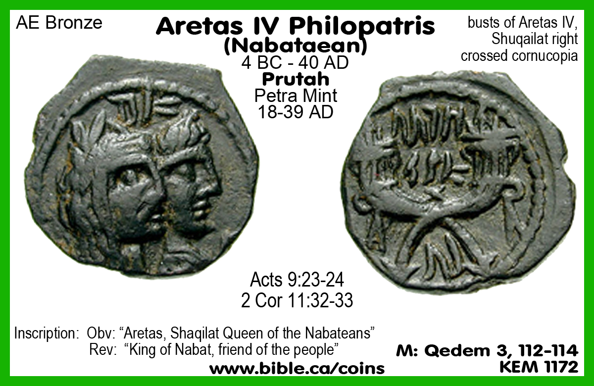
- The author excavated this coin of Aretas at Khirbet El-Maqatir (Ephraim of John 11) in December 2013 Cav1 of the underground bunker system that was destroyed by the Romans in AD 69.
- This proves Paul was converted before 40 AD and gives us help in dating other events in the New Testament.
V. Paul fulfilled the antitype of Moses as the lawgiver by visiting Mt. Sinai
- Paul went to Arabia immediately after being converted:
- "But when God, who had set me apart even from my mother’s womb and called me through His grace, was pleased to reveal His Son in me so that I might preach Him among the Gentiles, I did not immediately consult with flesh and blood, nor did I go up to Jerusalem to those who were apostles before me; but I went away to Arabia, and returned once more to Damascus." (Galatians 1:15–17)
- "This is allegorically speaking, for these women are two covenants: one proceeding from Mount Sinai bearing children who are to be slaves; she is Hagar. Now this Hagar is Mount Sinai in Arabia and corresponds to the present Jerusalem, for she is in slavery with her children. But the Jerusalem above is free; she is our mother." (Galatians 4:24–26)
- Where in Arabia would Paul go and why?
- Something important in Arabia made Paul go to Arabia at his conversion.
- Damascus was part of Nabatean Arabia at the time of his conversion, so if he was already in “Arabia” and he went to “Arabia”, this infers that he went to Petra, the capital city of Nabatean Arabia or Mt. Sinai in Arabia.
- If I was Paul and Aretas IV had just tried to kill me, I would go ANYWHERE but Arabia at Petra.
- When Paul went to Arabia, he would not go anywhere near Petra (Kadesh Barnea) because that is the royal city of Aretas IV who just tried to kill Paul.
- Paul was compelled to go to Mt. Sinai to fulfill the antitype of Moses as the primary lawgiver of the New Testament who would go on to write 14 of the 27 books that contain the majority of theological and doctrinal instruction.
- Just as Moses went to Mt. Sinai to learn the law directly from God, so too Paul went to Mt. Sinai to learn the law directly from Christ. This is exactly what Galatians 1:15-17 says!
- Paul is the Antitype of Moses who visited Mt. Sinai
immediately upon conversion:
Click here for Full quotations
|
|
List of 26 Moses/Paul Shadows and Antitypes |
||
|
|
“Shadow of what was to come, but the substance belongs to Christ” Col 2:17 |
Moses |
Paul |
|
1. |
Both were chosen from birth for a special divine purpose |
Ex 2:5 |
Gal 1:15 |
|
2. |
Both were outsiders, "Trojan Horses" who were brought into highest inner circle |
Ex 2:6 |
Acts 5:34; 21:39; 22:3, 25–29 |
|
3. |
Both had Kings who tried to kill them |
Ex 1:22; 2:15 |
2 Cor 11:32–33 |
|
4. |
Both escaped death through a woven basket |
Ex 2:3 |
2 Cor 11:32–33 |
|
5. |
Both received the top education the world had to offer: |
Ex 2:10; Acts 7:22 |
Acts 22:3; Phil 3:6 |
|
6. |
Both proved their faith by works before being commissioned by God |
Ex 2:11 |
Acts 22:4-5 |
|
7. |
Both murdered someone immediately before their conversions |
Ex 2:12 |
Acts 7:58; 9:1-2 |
|
8. |
Both were rejected by their brethren as a deliverers and saviors |
Acts 7:25 |
Acts 9:23-26; 22:18 |
|
9. |
Both talked to God after seeing a bright light in the wilderness |
Ex 3:2-3 |
Acts 9:3 |
|
10. |
Both asked God, “who are you” and God replied, "I AM" |
Ex 3:13–14 |
Acts 22:8 |
|
11. |
Both immediately fled to Mt. Sinai and received instruction |
Ex 2:15; Heb 11:27 |
Gal 1:17 |
|
12. |
Both received instructions directly from God on the law at Mt. Sinai |
Acts 7:38 |
Gal 1:15–17 |
|
13. |
Both were law givers who wrote major sections of scripture |
Pentateuch: 5 OT books |
14 NT books |
|
14. |
Both rejected earthly riches, position, and prestige for heavenly treasures |
Heb 11:26 |
Phil 3:4-8 |
|
15. |
Fellow Hebrews rejected the message of truth and salvation |
Acts 7:39 |
Acts 18:4–6 |
|
16. |
Both had fellow Jews who chose slavery and bondage over freedom and salvation |
Ex 14:11–12; Num 14:3–4 |
Gal 4:25; 5:1–4 |
|
17. |
Both performed spectacular and extraordinary miracles |
Acts 7:36 |
Acts 19:11–12 |
|
18. |
Both had speech impediments but produced powerful and impressive written documents |
Ex 4:10 |
2 Cor 10:10 |
|
19. |
Both were physically affected after they saw God |
2 Cor 3:7–8 |
2 Cor 12:4–7 |
|
20. |
Both repeatedly asked God for a request, but both were denied |
Deut 3:25-26 |
2 Cor 12:2-10 |
|
21. |
Paul removed the “mystery veil” of Moses by teaching about the glory of Jesus Christ |
Ex 34:33–35 |
2 Cor 3:12–18; Eph 3:1–6; Rom 16:25–27; Col 2:1–3 |
|
22. |
Writing on stone vs. spirit |
Ex 24:12; 2 Cor 3:7 |
2 Cor 3:2-3 |
|
23. |
Both endured persecution by stoning from fellow Hebrews they were trying to save |
Ex 17:3–4 |
Jn 8:59; 10:31; Acts 14:4–7; 19–20; 2 Cor 11:24–29 |
|
24. |
Both were opposed by false prophets of depraved mind |
2 Tim 3:8; Ex 7:11–13 |
1 Tim 6:3–5 |
|
25. |
Both became fearful during their mission and needed reassuring in what to speak |
Ex 6:11–13 |
Acts 18:9–10 |
|
26. |
Paul shared with Christ, the function of being Moses’ replacement by removing the veil |
Deuteronomy 18:18-19 |
Acts 3:19–24; 2 Cor 3:18–4:6 |
VI. All Ancient literary sources that Arabia was not the Sinai Peninsula:
A. Gordan Franz and Barry J. Beitzel misrepresent sources by saying the Sinai Peninsula = Arabia in AD 36:
- Gordon Franz mistakenly expands Arabia outside Goshen into the Sinai Peninsula and makes a false conclusion.
i. “Is Mount Sinai In Saudi Arabia?” (2000 AD)
ii. “Mt. Sinai is not at Jebel el-Lawz in Saudi Arabia” (2001 AD)
iii. “Where is Mount Sinai in Arabia (Galatians 4:25)?” (Bible and Spade, 2013 AD)
iv. “Where Is Mount Sinai In Arabia?” (Bible and Spade, 2015 AD)
b. Franz believes Moses crossed the Red Sea at Bitter Lake and Mt. Sinai is in the Sinai Peninsula at Mt. Sin-Bishar.
- Using Herodotus, Gordon Franz correctly identified the Arab occupied areas at Goshen inside Egypt and then infers, without any direct evidence, that the entire Sinai Peninsula was Arabia. He is unable to supply a single literary source that says that Arabs lived in the central or southern Sinai Peninsula, much less that they were considered Arabia. His approach is to define Arabia at the time of Paul everywhere, which means he can have his Mt. Sinai in the Sinai Peninsula.
- Gordon Franz comments:
- "Herodotus’ description would therefore include all of the Sinai Peninsula in Arabia of his day." (Where is Mount Sinai in Arabia: Galatians 4:25, Bible and Spade, 2013 AD)
- “The area of Saudi Arabia was one part of first century Arabia, but not the whole of Arabia. Thus the biblical Mount Sinai, located in the Sinai Peninsula, which in my opinion should be located at Jebel Sin-Bishar was in Arabia. … As one examines these accounts [i.e ancient literary sources], it will be seen that the vast territory of Arabia goes from the Nile Delta in eastern Egypt and the Arabian Gulf (Red Sea - Gulf of Suez) on the west, all the way over to the Persian Gulf on the east. It goes from Damascus in the north, to the tip of Yemen in the south. Today, the territory of first century Arabia would cover the areas of eastern Egypt, including the Sinai Peninsula, southern Israel, Jordan, and parts of Syria and Iraq, all of Saudi Arabia, Yemen, and the Gulf States on the Persian Gulf. It is not limited to Saudi Arabia or the northwest quadrant of Saudi Arabia as Cornuke has stated.” (Where is Mount Sinai in Arabia (Galatians 4:25)?, Bible and Spade, Gordon Franz, 2013 AD)
- Barry J. Beitzel misdefined the Sinai Peninsula as Arabia at the time of Paul in AD 36:
a. Barry J. Beitzel published article:
i. The Meaning of “Arabia” in Classical Literature and the New Testament, Lexham Geographic Commentary on Acts through Revelation, Barry J. Beitzel, Gal 1:17, 2019 AD
b. Beitzel believes Moses crossed the Red Sea at Timsah Lake and Mt. Sinai is in the Sinai Peninsula at Mt. Musa (St. Catharine’s). He believes the exodus population is thousands not millions.
c. Beitzel defines the Sinai Peninsula as Arabia (Nabatea? Petra?) at the time of Paul’s conversion in AD 36 without any direct literary evidence. While Strabo 17.1.21 calls Goshen “Arabia”, he does not extend “Arabia Goshen” east of the Suez Canal or the Gulf of Suez. Strabo did not consider the Sinai Peninsula to be part of Arabia.
d. Beitzel seemed unaware that Leuke Kome was the port of Petra and part of the Nabatean empire at the time of Paul. Goods were shipped by camel through Leuke Kome to Petra then to Rhinocolura. Archaeological excavations have found the same architecture (Crow-stepped, stone cut tombs) and assemblages (pottery) at Leuke Kome, Al Bad and Mt. Lawz/Maqnah as at Petra.
e. Beitzel ignored the fact that in AD 150, Ptolemy in 4.5.12-16 defined the northern Sinai Peninsula as Egyptian territory, not Arabia Petra. Ptolemy drew a diagonal line from Gaza down to Heroon city (northern tip of the Gulf of Suez) and said it was the eastern border of Egypt. Strabo said that Rhinocolura was in Syria not Arabia, even though Rhinocolura was an important Arabian controlled seaport for the spice trade at the time of Paul. After AD 50 the city reverted into Egyptian control. This is a significant oversite by Beitzel.
f. Barry J. Beitzel comments:
i. “Arabia (VI) = Arabia Petraea = Arabia of the Nabateans—the Sinai Peninsula and South and East of Judea” (The Meaning of “Arabia” in Classical Literature and the New Testament, Lexham Geographic Commentary on Acts through Revelation, Barry J. Beitzel, Gal 1:17, p532, 2019 AD)
ii. “Arabia Petraea: Sinai Peninsula and south and east of Judea north to Damascus”. (The Meaning of “Arabia” in Classical Literature and the New Testament, Lexham Geographic Commentary on Acts through Revelation, Barry J. Beitzel, Gal 1:17, p532, 2019 AD)
iii. “To which “Arabia” did Paul go immediately after his conversion? We can reasonably rule out Arabia (I) [Goshen], (II) [Rhinocolura], (III) [Nile cataracts], (IV) [Babylon], and probably (V) [Mt. Hermon], and Arabia (IX) [after AD 107] was not created until the early second Christian century. But this still leaves (VI) [Petra], (VII) [Felix], and (VIII) [Deserta], a wide territorial expanse.” (The Meaning of “Arabia” in Classical Literature and the New Testament, Lexham Geographic Commentary on Acts through Revelation, Barry J. Beitzel, Gal 1:17, p533, 2019 AD)
B. Dictionary of Ancient Place names:
1. Arabia Nabataea = Arabia Petra located inside Arabia Felix
2. Elanite/Ælanitic/Aelanites/Laeanite gulf = Gulf of Aqaba
3. Erythræan Sea = Red Sea
4. Eudaimon Arabia = Arabia Felix
5. Happy Arabia = Arabia Felix
6. Heroopolite gulf = Gulf of Suez
7. Idumeans = Idoumaia = Edomite Jewish proselytes living in the Judean Negev.
8. Nabatea = Nabatæa = Nabatean Kingdom = one of many Arab tribes in Arabia Felix
9. Petra = capital city of the Nabatean Kingdom in the district of Arabia Felix.
C. Eight geographic areas called Arabia or where Arabians lived from Literary Sources:
1. Arabia and the Nabatean Kingdom before AD 70:
a. At the time of Paul’s conversion in AD 36 and when he wrote Galatians in AD 53, there were two general Arabian territories named “Arabia Desert” and “Arabia Felix”. There were many autonomous Arab tribes living in Arabia Felix, but the Nabatean Kingdom at Petra was the most organized and powerful tribe, given they controlled the spice trade routes.
b. The Nabatean Kingdom was not a separate geographic district from Arabia Felix, but instead was entirely inside Arabia Felix. Nabatea was like a province within the larger country area of Arabia Felix. If you were going to mail a letter to the Nabatean king at Petra it would be addressed: “King Aretas, Petra, Nabatea, Arabia Felix, Arabia”.
c. First century Petra was the capital city of the Nabatean kingdom where king Aretas lived. At the time of the Exodus, Petra was Kadesh Barnea where Moses spent 38 years. At the time of Paul’s conversion in AD 36, Nabataea was considered Arabia, whose territory was entirely Transjordan from Mt. Hermon down to Midian at the Straits of Tiran. The commercial seaport of Petra was Leuke Kome at biblical Elim of the Exodus and modern Aynuna near Al Bad in Midian.
d. Petra is ancient Kadesh Barnea of the Exodus. Just as the Jews had prospered greatly by controlling the end port of the Philistine coastal trade route from the time of Joseph to Moses at Goshen, so too the Hebrews were located for 38 years at a strategic trade route crossroads at Kadesh Barnea 1444-1406 BC. This explains why the Petra was the capital of the trade routes of Arabia.
e. The Nabatean kingdom never extended into the Judean Negev or the Sinai Peninsula at the time of Paul. While there were pockets of Arab populations in cities on the southern Nile, Goshen in the Nile Delta, Rhinocolura and in the Judean Negev, none of the areas were under the direct control of the Nabatean king at Petra as his legal territory. For example, Goshen is in the Nile Delta and was called “Arabia” but everyone knew it was under Egyptian legal control. At the time of Joseph, the Hebrews lived in “the land of Goshen” but it was in Egypt.
f. In the early first century, Arab controlled cities existed in Judah and Egypt as part of the Arabian spice trade. The primary seaport on the Mediterranean was Rhinocolura/Arish. Six Nabatean cities are known to exist in the Judean Negev through literary sources and archaeological excavations: Elusa [Ptolemy, Geography 5.16.10; Peutinger map; Libanius Ep. 101, 132, 532, 536; Medaba map], Advat/Oboda [Ptolemy, Geography 5.17.4; Peutinger map], Ruheiba, Nessana [6th century AD papyri found on site], Sobata [Nessana papyri], and Mampsis/Maps/Mapsis/Kurnub [Ptolemy, Geography 5.16.10; Onomasticon 8.8]. These were in Judea not Arabia even though they were closely connected to the Nabatean trade routes through Petra.
g.
Leuke Kome in Midian was located in Arabia Felix and was part of the
Nabatean Kingdom. The most important trade route of the Nabatean kingdom was
where goods were shipped by sea from India and southern Arabia to the seaport
at Leuke Kome, which is the Biblical Elim at Ain
Ounah. A 25% tax was levied by king Aretas and the goods were loaded
onto camel caravans to Petra where they were then shipped through the Negev to
Rhinocolura/Arish. At this point they would be loaded onto ships for Greece and
other destinations via the Mediterranean Sea. Archaeology provides direct
evidence that Nabateans occupied Al Bad, Leuke Kome
(Aynuna) and the east side of the Mt. Lawz/Maqnah mountain range. A Nabatean
marble quarry and workshop have been excavated on the eastern slopes of Mt.
Maqnah. Arabia Petra, therefore, occupied the entire lands north of and
including the mountain range in North western Saudi Arabia.
2. Arabia Petra: After AD 70
a. After the destruction of Jerusalem in AD 70 and the defeat of Judea during the First Jewish War (AD 66-72), the Arabs filled the void in the Negev and moved into the Sinai Peninsula. This move is documented in AD 77 by Pliny the Elder, Natural History, 5.12.64-65. In AD 106, Trajan annexed the Sinai and created three distinct Roman provinces that formed Arabia: Arabia Petra, Arabia Deserta and Arabia Felix. However, in AD 150 Ptolemy 4.5.12-16 specifically excludes the northern Sinai from Arabia Petra and said it belonged to Egypt. Ptolemy defines Egypt as north of the line between Arsinoe (northern tip of Gulf of Suez) and Gaza.
b. “There is also in the land of the Nabataeans a rock [Petra], which is exceedingly strong since it has but one approach, and using this ascent they mount it a few at a time and thus store their possessions in safety. And a large lake [Salt Sea] is also there which produces asphalt in abundance, and from it they derive not a little revenue. … That part of Arabia which borders upon the waterless and desert country [Arabia Deserta south of Petra] is so different from it that, because both of the multitude of fruits which grow therein and of its other good things, it has been called Arabia Felix.” (Diodorus Siculus 2:48-49, 30 BC)
c. The new Roman province of Arabia Petra, formed in AD 106, included the central/south Sinai east of the Nile, the Judean Negev, Transjordan from Elat up to Mt. Hermon but did not include Midian near the straits of Tiran.
d. Midian in northwest Saudi Arabia had been considered Arabia Felix from before 100 BC. While the Nabatean Kingdom at the time of Paul controlled Midian and Leuke Kome, after AD 106 this area was removed from Arabia Petra.
e. Before AD 106, the Nabatean Kingdom operated inside Arabia Felix. After AD 106 Arabia Felix and the Nabatean Kingdom became two distinct legal territories: Arabia Felix and Arabia Petra. Arabia Petra lost the area around Midian but gained the central and southern Sinai Peninsula. Arabia Felix retained the area around Midian but lost the Transjordan area of the Nabatean kingdom.
3. Arabia Felix: Arabia Happy, Eudaimon: Gal 4:25
a. Gal 4:25 proves that Mt. Sinai must be in “Arabia Felix” because Hagar’s children settled in Arabia Felix not the Sinai Peninsula or Arabia Petra.
b. When ancient geographers referred to “Arabia” they almost always referred exclusively to “Arabia Felix” which they considered “Arabia proper”.
c. There is universal agreement that Arabia Felix is entirely Transjordan and is bounded by the Persian and Arabian Gulfs, south of Mt. Hermon and Midian, and excludes Arabia Deserta.
d. There is universal agreement that at no point in history has Arabia Felix included the Judean Negev or the Sinai Peninsula.
e. Before AD 106, the Nabatean Kingdom operated inside Arabia Felix. After AD 106 Arabia Felix and the Nabatean Kingdom became two distinct territories: Arabia Felix and Arabia Petra. Arabia Petra lost the area around Midian but gained the central and southern Sinai Peninsula. Arabia Felix retained the area around Midian but lost the Transjordan area of the Nabatean kingdom.
f. Midian (Al Bad), the Wilderness of Shur, Leuke Kome (Biblical Elim at modern Aynuna) have always been in Arabia Felix where Mt. Sinai was located. This simple truth brings clarity to the location of Mt. Sinai.
4. Arabia Deserta:
a. The geographic territories of Arabia Deserta remained the same before and after AD 106.
b. Arabia Deserta was the Syro-Arabian Desert (Great Eastern Deserts) from the Euphrates down interior of the Arabian Peninsula. Ancient geographers identified the great central desert in the Arabian Peninsula but were not well acquainted with the full extent of its size in the interior. Strabo correctly understands that on the Persian Gulf side, Arabia Deserta was above Arabia Felix but on the Arabian Gulf side Arabia Felix included the Wilderness of Shur at the Straits of Tiran all the way south to the Indian Ocean.
c. Arabia Deserta was inhabited sparsely because it was a sand desert. Arab caravans would traverse the deserts by having hidden water wells at locations only they knew about. “For in the waterless region, as it is called [Arabia Deserta], they have dug wells at convenient intervals and have kept the knowledge of them hidden from the peoples of all other nations, and so they retreat in a body into this region out of danger. For since they themselves know about the places of hidden water and open them up, they have for their use drinking water in abundance; but such other peoples as pursue them, being in want of a watering-place by reason of their ignorance of the wells, in some cases perish because of the lack of water and in other cases regain their native land in safety only with difficulty and after suffering many ills. Consequently the Arabs who inhabit this country [Arabia Deserta], being difficult to overcome in war, remain always unenslaved; furthermore, they never at any time accept a man of another country as their over-lord and continue to maintain their liberty unimpaired. Consequently neither the Assyrians of old, nor the kings of the Medes and Persians, nor yet those of the Macedonians have been able to enslave them, and although they led many great forces against them, they never brought their attempts to a successful conclusion. … That part of Arabia which borders upon the waterless and desert country [Arabia Deserta south of Petra] is so different from it that, because both of the multitude of fruits which grow therein and of its other good things, it has been called Arabia Felix.” (Diodorus Siculus 2:48-49, 30 BC)
d. “I return to the opinions of Eratosthenes, which he next delivers respecting Arabia [Deserta]. He is speaking of the northern and desert part, lying between Arabia Felix, Cœle-Syria, and Judæa, to the recess of the Arabian Gulf [interior portion of Arabian Peninsula].” Strabo, Geography 16.4.2
e. “Above these is a great desert [Arabia Deserta]; but the parts lying still more to the south are occupied by the nations inhabiting Arabia Felix, as it is called. The northern side of this tract [Arabia Felix] is formed by the above-mentioned desert [Arabia Deserta], the eastern by the Persian, the western by the Arabian Gulf, and the southern by the great sea [Arabian Sea] lying outside of both the gulfs, the whole of which is called the Erythræan Sea [Red Sea].” (Strabo, Geography 16.3.1)
5. Arabia Rhinocolura/Arish: As late as AD 542, the Madaba map identified Rhinocolura/Tharu/Arish as the historic and Biblical border between Egypt and Israel (Gen 15:18). The Babylonian captivity was 605-536 BC and the Hebrews returned to finish the Jerusalem temple in 515 BC and the city walls in 445 BC. During this time, while Judea was in Babylon and the Negev was vacant of Jews, the Nabateans moved in. Rhinocolura was one of the most important Arab controlled shipping ports of the Arabian empire. Several ancient geographers describe Arabia as a narrow 50 km strip of seacoast centered at the port of Arish. It did not extend south into the Sinai Peninsula, but extended west towards Lake Serbonis and east towards Gaza. These ancient geographers note that the 80 km of shoreline between Pelusium to “Arabia” was controlled by the Syrians or Egyptians. “Arabia” ended 10-20 km west of Arish and 20-30 km east of Arish. This enabled the Nabateans to control a continuous corridor of land on either side of their trade route from Petra, through the Negev south of Beersheba to Rhinocolura. These Arabian controlled lands provide no evidence for the Sinai Peninsula being defined as Arabia at the time of Paul.
6. Arabia Goshen: During the vacuum of the Babylonian captivity (605 – 536 BC), the Arabians moved into the eastern Nile delta at Biblical Goshen where the Hebrews spent 430 in Egyptian bondage. As early as 500 BC Biblical Goshen was described as “Arabia” by several ancient geographers during the Persian empire, but it was always understood to be in Egyptian territory. During this Persian period Arabia included Rameses/Avaris at Tel el-Dab’a, Pithom at Tel Retaba and the Wadi Tumilat. The Septuagint translators in 282 BC called Goshen “Arabia” because of the large populations of Arabs living there at the time of the Greek kingdom. Some ancient geographers describe “Persian Arabia” as extending south to the port of Suez at Arsinoe, because the Arabians controlled all the trade routes at these key ports. Just as the Hebrews controlled the end of the Philistine coastal trade route at Goshen, the Arabians moved into this key location which also controlled the port of Suez at Arsinoe. It was Egyptian territory with large populations of Arabs living in these key trade route cities. Goshen was described as “Arabia” the same way we would describe “Chinatown” in New York City. What is important is that these same geographers who describe “Arabia Goshen” extending to the Gulf of Suez (Red Sea) do not extent “Arabia Goshen” further eastward into the Sinai Peninsula. “Arabia Goshen” stopped at the Suez Canal and Gulf of Suez, therefore excluding the entire Sinai Peninsula as Arabia. This is a significant observation missed by some who define the central and southern Sinai Peninsula as Arabia where they locate their choice for Mt. Sinai.
7. Arabia Nile Cataracts: Ancient historians indicate large populations of Arabs inhabited and controlled a series of cities between the first and second cataracts on lake Nassar at the border of Egypt and Nubia/Ethiopia. Although this area was never called “Arabia” ancient historians did call them “Arabian towns”, including Pselcis, Primi [Primis], Boechis, Cambyses’ Market, Attenia and Stadissis at the second cataract. This follows a pattern of the Nabateans controlling all the major border entrance ports at Leuke Kome (Port Petra), Rhinocolura (Port Mediterranean) and Arisinoe (Port Suez) and here at “Port Egypt” on the Nile. Goods shipped up the Nile from southern Africa would be controlled and taxed to benefit the Arabians.
8. Arabia Babylon: Arabia Deserta begins at the Euphrates River. Some ancient geographers described “Arabia” as between the Euphrates and Tigris rivers at the time of Alexander the Great. These were Arab controlled areas that served as end points of their trading routes like Rhinocolura. While the area between the rivers is well understood to be Babylonian it was described as Arabia because it was directly adjacent to Arabia proper and there was a large population of Arabs living there.
VII. Ancient Historians define Arabia as excluding the Sinai Peninsula:
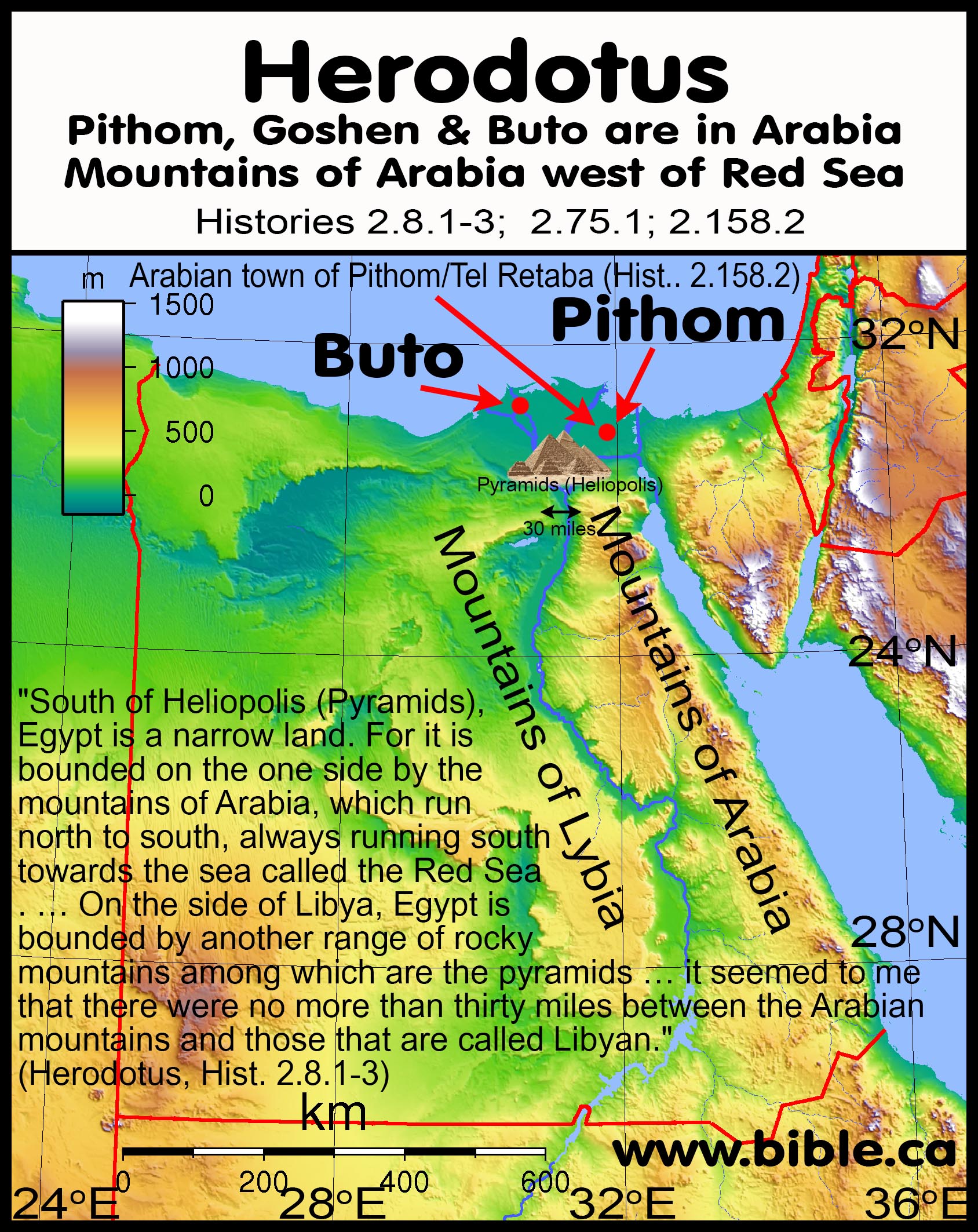
A. 484 BC Herodotus and "Arabia" at Goshen and Arish/Tharu/Rhinocolura:
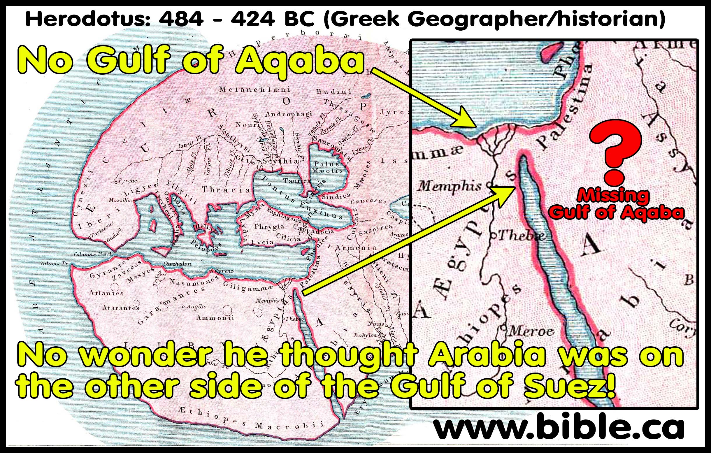
MASTER SUMMARY: 484 BC: Herodotus. Twice Herodotus tells us (2:12,19) that his geography in Arabia was based upon a secondhand report from another and not firsthand experience. Herodotus believed in a flat earth (4.36.2) and had no concept of the Gulf of Aqaba. Without the Gulf of Aqaba, Arabia begins in the Sinai Peninsula! “Herodotus knows nothing of the modern Persian Gulf or of the shape of Arabia. His ‘Assyria’ consists of the basins of the Euphrates and Tigris below Armenia (i. 178. 1 n.), and his ‘Arabia’ includes the southern part of the desert as well as Arabia proper. … The three nations are Assyria and Arabia with Phoenicia, not with Persia (as Macan); Persia is the base of the ἀκτή, not part of it.” (A Commentary on Herodotus, W. How, Herodotus 4.39, 2000 AD) However, in 3.107.1 Herodotus understood that Arabia proper, "the nation" was nowhere near Egypt or the Sinai Peninsula but located in Saudi Arabia. He also called Goshen Arabia (17.1.21) and Arish/Tharu/Rhinocolura an Arabian town (2.158.2). Herodotus said the Nile flooded Arabia in Goshen (2:19). Herodotus records how during the Babylonian captivity (605-536 BC) when Israel was vacant from Canaan, both Syrian and the Arabians moved into the coastal areas between Gaza and the Serbonian marsh. In 568 BC, Nebuchadnezzar conquers Egypt. The Jews completed the temple in 515 BC but did not finish the walls of Jerusalem until 445 BC. It was at exactly this time that Herodotus wrote his account, and the Arab occupation of these seaports in 450 BC do not reflect the geographic territory of Arabia in the first century. At the time Herodotus wrote his history, the Jews remained a tiny occupied vassal-state under Persian control down to the time of Alexander the Great in 333 BC. Herodotus understood Arabia proper to be Saudi Arabia but noted that the Arabs controlled a few key Seaports on the Mediterranean. Herodotus says that this small 50 km coastal strip of Arab controlled seaports was flanked on the western side by 100 km of Syrian controlled land to Pelusium and on the eastern side all the way up the coast to the north. This refutes the fiction that the Sinai Peninsula was considered Arabia by Herodotus because the Arabian controlled seaports were flanked on either side by much larger Syrian controlled territories from the Nile to Tyre. This small, isolated 50 km strip of Arab controlled land was not Arabia, but the end of their trading routes on the Mediterranean coast. Herodotus notes that the Arabs inhabited the area of ancient Goshen at Pithom which lay at the end of the ancient coastal trading route that went north to Philistia through Gaza, Tyre and Byblos etc. Herodotus describes how Syrian Gentiles controlled Gaza, but the Arabs controlled the seaports of Raphia and Arish/Tharu/Rhinocolura (3.5.1–3). These Arab controlled seaports were not considered “Arabia” but end points of the Arab trade routes. In AD 15, Strabo notes that Rhinocolura continued as an Arabian controlled seaport for the trade route from Leuke Kome to Petra to Rhinocolura. Herodotus placed the Mountains of Arabia west of the Red Sea (Arabian Gulf). These mountains are not in Arabia they are in Egypt. They are call Arabian mountain because they flank the border with Arabia on the other side of the Red Sea (2.8.1-3; 2.124.2-3). Herodotus called Buto an Arabian town which was located near Alexandria. Strabo tells us that Alexandria was the final destination stop for Arabian goods shipped from Arabia and India by ship up the Arabian Gulf to Myos Hormos to Coptus, then to Alexandria. Buto was one of several key towns in which the Egyptians performed ritual sacrifices (2.58.1–60.3; 63.1). Buto, Pithom and Rhinocolura were not Arabia, but towns populated and used by Arabs as part of their spice trade routes. New York City is not part of China because a section is called Chinatown. Herodotus provides no evidence that any part of Egypt inside the Nile Delta was ever considered to be Arabia proper.
- Herodotus: 484 BC understood that Arabia proper, "the nation" was nowhere near Egypt or the Sinai Peninsula. As a result of the Babylonian captivity, where the Jews were a small population in Jerusalem, Herodotus 2.116.6 describes how Egypt directly abutted Syria not Arabia. This proves that when Herodotus calls small geographical areas “Arabia” he is referring to pockets of Arab control, not saying it is the land of Arabia.
- "Again, Arabia is the most distant to the south of all inhabited countries: and this is the only country which produces frankincense and myrrh and casia and cinnamon and gum-mastich. All these except myrrh are difficult for the Arabians to get." (Herodotus, Hist. 3.107.1)
- “In these verses the poet [Homer c 650 BC] shows that he knew of Alexander’s wanderings to Egypt; for Syria borders on Egypt, and the Phoenicians, to whom Sidon belongs, dwell in Syria.” (Herodotus, Histories 2.116.6)
- "On this peninsula live thirty nations. This is the first peninsula. But the second, beginning with Persia, stretches to the Red Sea, and is Persian land; and next, the neighboring land of Assyria; and after Assyria, Arabia; this peninsula ends (not truly but only by common consent) at the Arabian Gulf, to which Darius brought a canal from the Nile." (Herodotus, Hist. 4.38.2–39.1)
- Twice Herodotus tells us that his geography in Arabia was based upon a secondhand report from another and not firsthand experience: 2:12,19.
- Herodotus believed in a flat earth and had no concept of
the Gulf of Aqaba. Without the Gulf of Aqaba, Arabia begins in the Sinai
Peninsula! But this explanation is not needed when you understand the
context of what Herodotus is actually saying about Goshen and
Arish/Tharu/Rhinocolura. Here is a catalogue
of over 50 historic exodus route maps.
- Like Strabo, Herodotus defines ancient Goshen as Arabia
- Pithom is south-east of Tel El-Dab'a (Goshen) inside the Nile Delta of Egypt: "Arabian town of Patumus [Pithom, Tell el-Retaba]" (Herodotus, History 2.158.2)
- “The country between the Nile and the Arabian Gulf is Arabia, and at its extremity is situated Pelusium.” (Strabo, Geography 17.1.21)
- Strabo describes Goshen as between the Nile and the Gulf of Suez. Strabo does not say that Goshen is all the land east of the Nile to Judea, but marks the eastern boundary of Goshen at the Gulf of Suez. This follows the translators of the Septuagint in 282 BC who also called ancient Goshen, “Arabia”. This is because of the large population of Arabs who lived there. Many major cities today have large populations of Chinese called “Chinatown”, but it is understood to be the USA, not China. Likewise, Goshen was called Arabia in the same sense of “Arabtown”. The Hebrews living in Goshen during the 430-year captivity controlled the final caravan terminal at the end of the Philistine highway that went up the coast through Gaza and Tyre. The Arabs had moved into ancient Goshen to control not only the caravan routes themselves, but also the end terminals where goods would be unloaded from the camels. There were a series of seaports also occupied by the Arabs south of Gaza that included Arish. The Sinai was not considered Arabia because the Arabs controlled the final shipping ports.
5. Herodotus said that Egypt abutted Syria not Arabia:
a. Herodotus did not say that Ienysus (Rhinocolura) was part of Arabia. Herodotus defined Arish/Tharu/Rhinocolura as a seaport “belonging to the Arabians” because it was part of the trade route from India. In AD 15, Strabo 16.4.24 described the trade route that utilizes the Rhinocolura seaport, but says that Rhinocolura is part of Phoenicia not Egypt or Arabia. Both Herodotus and Strabo understood that Rhinocolura was not part of Arabia and suggesting it is Arabian territory is a mistake.
b. “In 312 bce, with the help of Ptolemy in Egypt, Seleucus was able to retake Babylonia (inaugurating the “Seleucid era”), and later treaties allotted him the huge territory stretching from northern Syria to the borders of Egypt, including Asia Minor. His descendants ruled over this diverse empire for the next two and a half centuries.” (New Interpreter’s Dictionary of the Bible, Seleucid Empire, Volume 5, Page 158, 2009 AD)
c. “The question naturally arises as to when the Arabian king had gained control of Gaza and the associated coastal strip. There is no hint of such a situation during Nebuchadnezzar’s campaigns in the final years of the seventh and the early years of the sixth centuries b.c.e. Three broad possibilities come to mind: either the Arabians were encouraged to occupy Gaza and the northern Sinai coast by Nabu-naid during his ten-year sojourn in northern Arabia when he was developing the infrastructure to support the extensive caravan trade from Babylon and the lands of southern Arabia (552–542 b.c.e.), or the seizure of Gaza might have come in the aftermath of Nabu-naid’s return to Babylon in 542 b.c.e. or after the news went out that Cyrus had captured Babylon (539 b.c.e.). The identity of these Arabians may find confirmation in the inscribed silver bowl from Tell el-Maškhûta in Egypt. The Aramaic inscription reads זי קינו בר גשמ מלכ קדר קרב להנלאת “That which Qainu son of Gašem king of Qedar presented to Hanʾallat” (Rabinowitz 1956: 2). Southwest from Gaza the sphere of Arabian control extended, as Herodotus explained: “from Kadytis, a town, I should say, not much smaller than Sardis, the seaports as far as Ienysus belong to the Arabian.” The “Arabian strip” extended to a place called Ienysus [Rhinocolura].” (Herodotus’ Description of the East Mediterranean Coast, Anson F. Rainey, BASOR 321, p60, 2001 AD)
d. “Now the only apparent way of entry into Egypt is this. The road runs from Phoenicia as far as the borders of the city of Cadytis [or Kadytis = Gaza], which belongs to the so-called Syrians of Palestine [Gentiles]. From Cadytis (which, as I judge, is a city not much smaller than Sardis) to the city of Ienysus [Arish= Tharu = Rhinocolura] the seaports belong to the Arabians; then they are Syrian again from Ienysus as far as the Serbonian marsh, beside which the Casian promontory stretches seawards; from this Serbonian marsh, where Typho is supposed to have been hidden, the country is Egypt.” (Herodotus, Hist. 3.5.1-3)
e. “The ancient geographers did not usually extend ‘Arabia’ to the Mediterranean, nor does Herodotus himself in iv. 39. He means here that the ends of the trade routes from Arabia to the Mediterranean were under Arabian control (cf. iii. 107 seq. for this spice trade); he writes τοῦ Ἀραβίου, ‘in possession of the Arabian,’ not τῆς Ἁραβίης, For the Arabs of South Palestine as dependent allies (not subjects) of the Persians cf. 88. 1 n.” (A Commentary on Herodotus, W. How, Herodotus 3.5.2, 2000 AD)
- Buto is possibly the archeological site of Tell al-Fara'in near Rosetta in the north western Nile delta. Since Strabo 16.4.24 details the trade route from India and Arabia through Myos Hormos to Coptus to Alexandria, it is not surprising that an area near Buto , which was near Alexandria, would be an Arabian controlled town like Rhinocolura. Just as Alexandria and Buto were Egyptian, so too Rhinocolura was considered part of Syria not Arabia.
- "There is a place in Arabia not far from the town of Buto where I went to learn about the winged serpents. (Herodotus, Hist. 2.75.1–76.3)
- Herodotus describes how Buto was one of 5 major cult centers of Egyptian worship where sacrifices were offered (Herodotus, Hist. 2.58.1–60.3; 2.63.1).
- Herodotus described the “Mountains of Arabia” west of the Red Sea (Arabian Gulf), flanking Egypt and Ethiopia. The Troglodytes are the descendants of Keturah and Abraham, and are never called Arabs or Arabian. They lived along the seacoast and as “cave dwellers” by definition, may have inhabited the mountains.
- Strabo, Geography 1.2.34 assigns the territory of the Troglodytes (cave dwellers) on the western coast of the Arabian Gulf beside Egypt and Ethiopia from the Gulf of Aqaba to the south.
- "To some, he assigned the task of dragging stones from the quarries in the Arabian mountains to the Nile" (Herodotus, Hist. 2.124.2)
- "Beyond [to the south] and above Heliopolis (5 km east of the great Pyramids of Giza), Egypt is a narrow land. For it is bounded on the one side by the mountains of Arabia, which run north to south, always running south towards the sea called the Red Sea. In these mountains are the quarries that were hewn out for making the pyramids at Memphis. This way, then, the mountains run, and end in the places of which I have spoken; their greatest width from east to west, as I learned by inquiry, is a two months’ journey, and their easternmost boundaries yield frankincense. [2] Such are these mountains. On the side of Libya, Egypt is bounded by another range of rocky mountains among which are the pyramids” (Herodotus, Hist. 2.8.1-3)
B. 282 BC Septuagint: “Goshen of Arabia” = Heliopolis/Heroonopolis = “City of Heros” = Tell el-Maskhuta:
MASTER
SUMMARY: 282 BC Septuagint: In 282 BC 70 top Hebrew scholars were sent
from Jerusalem to Alexandria to translate the Torah from Hebrew into Greek at
the request of Ptolemy II for his father’s Library of Alexandria and the result
is the Septuagint (LXX). The translation of the Septuagint was the seed that
spawned the Synagogue system in 280 BC in Alexandria when spiritually thirsty
diaspora Jews gathered in homes to read their new Greek Torah for the first
time in their lives and pray to YHWH. Since Hebrew had been extinct among the
Jewish population since 500 BC, this became the standard “pulpit Bible” in the
thousands of synagogues all around the world and was used exclusively in Judea
at the time of Christ and the Apostles. Only the Temple Sadducees continued to
speak Hebrew in their worship services to an Aramaic and Greek speaking
audience the same way Roman Catholics today use Latin in English speaking
audiences. These Jerusalem Temple approved scholars were the ones who
anachronistically updated the ancient Hebrew place-names to reflect their
current name. They updated 4 Bible verses that are helpful for us today in
understanding the Exodus Route. Lake Goshen, also known in Egyptian
inscriptions (Papyrus Anastasi VI:4) as Lakes of Pithom and was located in the
Wadi Tumilat, as was the city of Goshen (Heliopolis/Heroonopolis = “City
of Heros” = Tell el-Maskhuta) and Pithom (Tell el-Retaba), all of which were
inside the land of Goshen. During the 430 years of Egyptian captivity, the
Hebrews enjoyed great prosperity because Goshen included the lake at Wadi
Tumilat which intercepted imported goods from the Red Sea. Likewise Rameses
(Tel el Dab’a) intercepted goods as an end port for the coastal trade route
called the Way of the Philistines. During the Babylonian captivity, the
Arabians moved into key trading city locations like Rhinocolura/Arish and
Goshen. During the Persian kingdom Darius I dug the Suez canal through the Wadi
Tumilat from the Nile river at Bubastis down to the Gulf of Suez. This became a
major trade route which the Arabians came to dominate. Herodotus in 484 BC
records how Pithom was populated by Arabians. "Arabian town of Patumus
[Pithom, Tell el-Retaba]" (Herodotus, History 2.158.2). During the Greek
kingdom when the Septuagint was translated, the Arabians continued to populate
the land of Goshen around the Wadi Tumilat. It is not surprising that the
Hebrew translators made anachronistic substitutions to reflect the contemporary
reality of Arabian control of key trade route cities like Heliopolis.
Identifying the southern border of the promised land with Rhinocolura/Arish
echoes Gen 15:18 and proves Kadesh Barnea cannot be at Ain el-Qudeirat because
it is inside the promised land, in spite of the fact that this is where every
map in the back of every Bible wrongly marks Kadesh Barnea.
The LXX translators anachronistic updated these four passages:
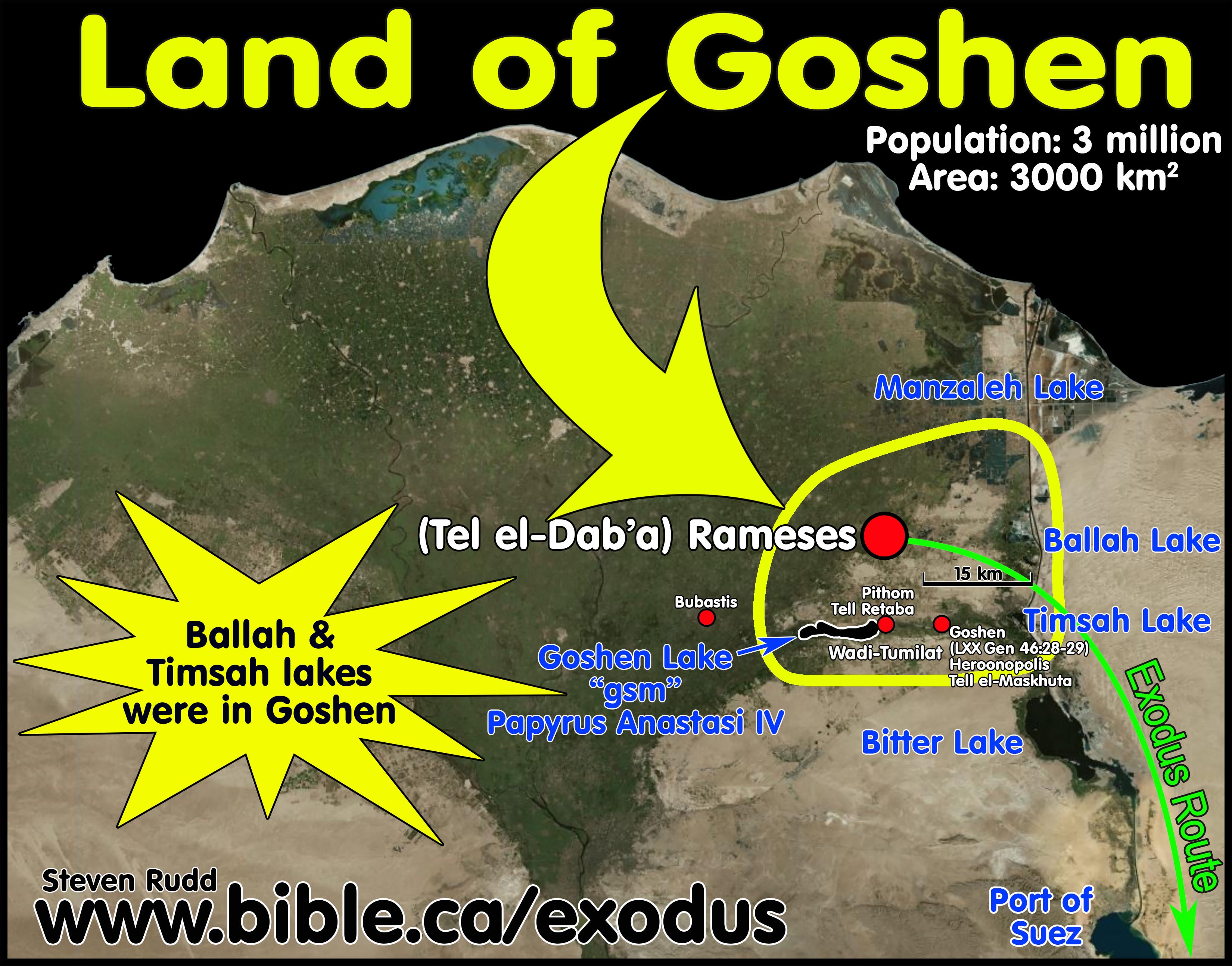
1. The translators updated these four passages:
a. Septuagint adds “of Arabia” to “Goshen” in Gen 45:9-10
b. Septuagint substitutes “Heliopolis” for “Goshen” in Gen 46:28-29
c. Septuagint adds “On which is Heliopolis” in Ex 1:10
d. Septuagint substitutes “Rhinocolura” for “Brook of Egypt” in Isaiah 27:13
2. Septuagint adds “of Arabia” to “Goshen” in Gen 45:9-10:
|
Septuagint adds “of Arabia” to “Goshen” in Gen 45:10 |
|
|
Masoretic Hebrew Text |
Septuagint Greek Text |
|
MT: "You shall live in the land of Goshen." (Gen 45:10, MT) |
LXX: "You will dwell in the land of Goshen of Arabia." (Gen 45:10, LXX) |
a. “Hurry and go up to my father, and say to him, ‘Thus says your son Joseph, “God has made me lord of all Egypt; come down to me, do not delay. “You shall live in the land of Goshen, and you shall be near me, you and your children and your children’s children and your flocks and your herds and all that you have." (Genesis 45:9–10, MT)
b. "Therefore, hurrying, go up to my father and say to him, ‘This is what your son, Joseph, says: “God has made me lord of all the land of Egypt. So, come down to me, and do not remain there. And you will dwell in the land of Goshen of Arabia, and you will be near me, you and your sons and the sons of your sons, your sheep and your oxen, even as many things as to you there are." (Genesis 45:9–10, LXX 282 BC)
3. Septuagint substitutes “Heliopolis” for “Goshen” in Gen 46:28-29
|
Septuagint substitutes “Heliopolis” for “Goshen” in Genesis 46:28-29 |
|
|
Masoretic Hebrew Text |
Septuagint Greek Text |
|
MT: " Joseph, to point out the way before him to Goshen" (Gen 46:28-29, MT) |
LXX: " Joseph to meet him down in the City of Heroes in the land of Rameses." (Gen 46:28-29, LXX) |
a. The city of Goshen was in the land of Goshen and was called Heliopolis or Heroonopolis, which means “City of Heros” and is located at Tell el-Maskhuta.
b. "Now he sent Judah before him to Joseph, to point out the way before him to Goshen; and they came into the land of Goshen. Joseph prepared his chariot and went up to Goshen to meet his father Israel; as soon as he appeared before him, he fell on his neck and wept on his neck a long time." (Genesis 46:28–29, MT)
c.
"He sent Judah before them to Joseph to meet him down in the City of Heroes [Heliopolis] in the land of Rameses.
Joseph, having harnessed his chariots, went up to a meeting with Israel, his
father, at the City of Heroes and, seeing him,
he fell upon his neck, and he wept with rich weeping." (Genesis 46:28–29,
LXX, 282 BC)
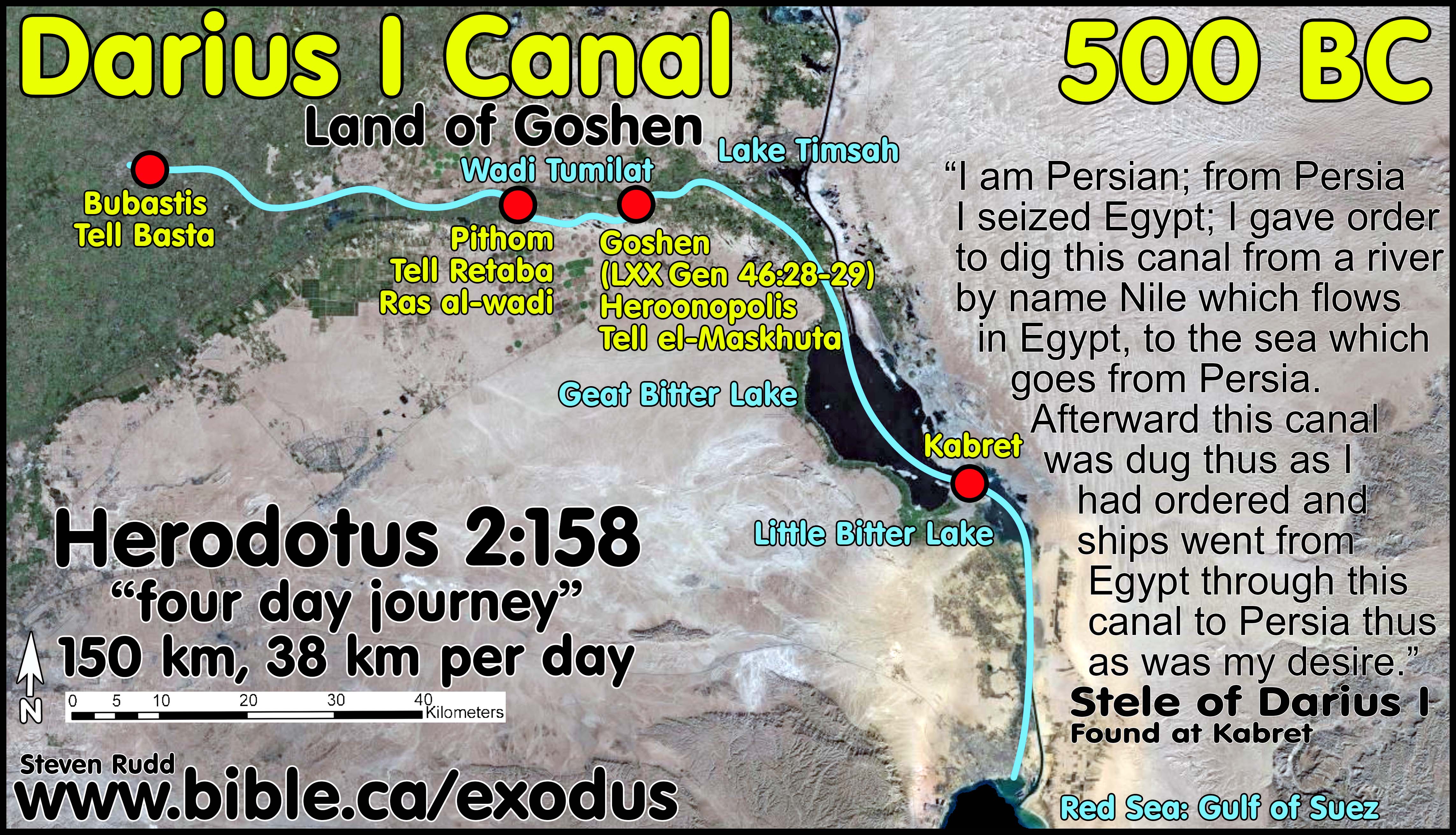
4. Septuagint adds “On which is Heliopolis” in Ex 1:10:
|
Septuagint adds “On which is Heliopolis” in Ex 1:10 |
|
|
Masoretic Hebrew Text |
Septuagint Greek Text |
|
MT: "And they built for Pharaoh storage cities, Pithom and Raamses." (Ex 1:10, MT) |
LXX: "So they constructed fortified cities for Pharaoh, both Pithom, Rameses, and On, which is Heliopolis." (Ex 1:10, LXX) |
a. Heliopolis or Heroonopolis means “City of Heros” and is located at Tell el-Maskhuta and is the city of Goshen which was in the land of Goshen on the north shore of the Wadi Tumilat.
b. “Come, let us deal wisely with them, or else they will multiply and in the event of war, they will also join themselves to those who hate us, and fight against us and depart from the land.” So they appointed taskmasters over them to afflict them with hard labor. And they built for Pharaoh storage cities, Pithom and Raamses." (Exodus 1:10–11, MT)
c. “Come, therefore, let us deal shrewdly with them, lest they multiply greatly, and in case war may happen to us, these people also will reinforce our enemies, and, defeating us in war, they will go forth out of the land.” And so he placed over them supervisors of the works in order that they could afflict them in their labors, and so they constructed fortified cities for Pharaoh, both Pithom, Rameses, and On, which is Heliopolis. Exodus 1:10–11, LXX, 282 BC)
5. Septuagint substitutes “Rhinocolura” for “Brook of Egypt” in Isaiah 27:13, echoing Gen 15:18:
|
Septuagint substitutes “Rhinocolura” for “Brook of Egypt” in Isaiah 27:12 |
|
|
Masoretic Hebrew Text |
Septuagint Greek Text |
|
MT: "flowing stream of the Euphrates to the brook of Egypt." (Isaiah 27:12, MT) |
LXX: " channel of the river as far as the Rhinocolura. " (Isaiah 27:12, LXX) |
a. "In that day the Lord will start His threshing from the flowing stream of the Euphrates to the brook of Egypt, and you will be gathered up one by one, O sons of Israel." (Isaiah 27:12, MT)
b. "And this will happen on that day: God will fence in the people from the channel of the river as far as the Rhinocolura. But as for you, gather the children of Israel one by one." (Isaiah 27:12, LXX)
c. "On that day the Lord made a covenant with Abram, saying, “To your descendants I have given this land, From the river of Egypt as far as the great river, the river Euphrates:" (Genesis 15:18)
d. Here we have direct evidence that the Wadi el-Arish is the history southern border of the promised land. This rules out Ain el-Qudeirat as Kadesh Barnea found in every map found in the back of Bibles and Mt. Karkom as Mt. Sinai.
6. Goshen
was Tell el-Maskhuta; Pithom was Tell Retaba. Both on the shores of Wadi
Tumilat:
![]()
a. Lake Goshen (Lakes of Pithom) in the Wadi Tumilat, the city of Goshen (Heroonpolis = Tell el-Maskhuta) and Pithom (Tell el-Retaba) were all inside the land of Goshen.
b. “The Septuagint of Genesis 46:28–29 changes Goshen to Heroonpolis and appears to locate the land of Goshen at Wadi Tumilat. Heroonpolis is most likely identifiable with Tell el-Maskhuta.” (On the Historicity of the Exodus: What Egyptology Today Can Contribute to Assessing the Biblical Account of the Sojourn in Egypt, Manfred Bietak, Israel's Exodus in Transdisciplinary Perspective, Editor-Thomas E. Levy, p21, 2015 AD)
c. “Pithom in the Bible can be identified with the only known settlement of the Ramesside Period in the Wadi Tumilat, at Tell el-Retaba, not with Tell el-Maskhuta which according to the archaeological record did not yet exist.” (On the Historicity of the Exodus: What Egyptology Today Can Contribute to Assessing the Biblical Account of the Sojourn in Egypt, Manfred Bietak, Israel's Exodus in Transdisciplinary Perspective, Editor-Thomas E. Levy, p31, 2015 AD)
C. 169 BC Agatharchides and "Arabia" in Saudi Arabia not the Sinai Peninsula:
MASTER SUMMARY: 169 BC: Agatharchides said Arabia was in Saudi Arabia. “The merchants, dock workers and shopkeepers of Alexandria profited nicely from the massive trade that passed through their city to and from southern Arabia and India. For them, "Arabia" meant the Arabian Peninsula. Precisely the same usage is found in the works of Alexandrian intellectuals such as the geographers Eratosthenes and Agatharchides.” (Mt. Sinai in Arabia?, Allen Kerkeslager, Bible Review, 16:02, 2000 AD) Agatharchides is unique in that he is one of the few early geographers of his day that correctly understood the Gulf of Aqaba calling it the "Laeanites/Aelanites Gulf". He restricts "Arabia" to south and east of the Gulf of Aqaba. Agatharchides did not sail down the Laeanites Gulf, but says the Arabs live on the east/south shore of the Gulf of Aqaba and that at the end of the Gulf, is Petra! No Arabians lived in the Sinai Peninsula. As he sails down the Red Sea towards the Indian Ocean, he describes all the various tribes of Arabians only after reaching the place in the Red Sea where the Gulf of Aqaba branches off the Arabian Gulf. “Then there is the Aelanites Gulf [Aqaba] and Nabataea” (Agatharchides, book 5, fragment 90b, quoted by Strabo 16.4.18, 15 AD). “After what is called the Laeanites Gulf [Aqaba], around which Arabs live” (Agatharchides book 5, fragment 91a, quoted by Photius Cod. 250.89, 897 AD).
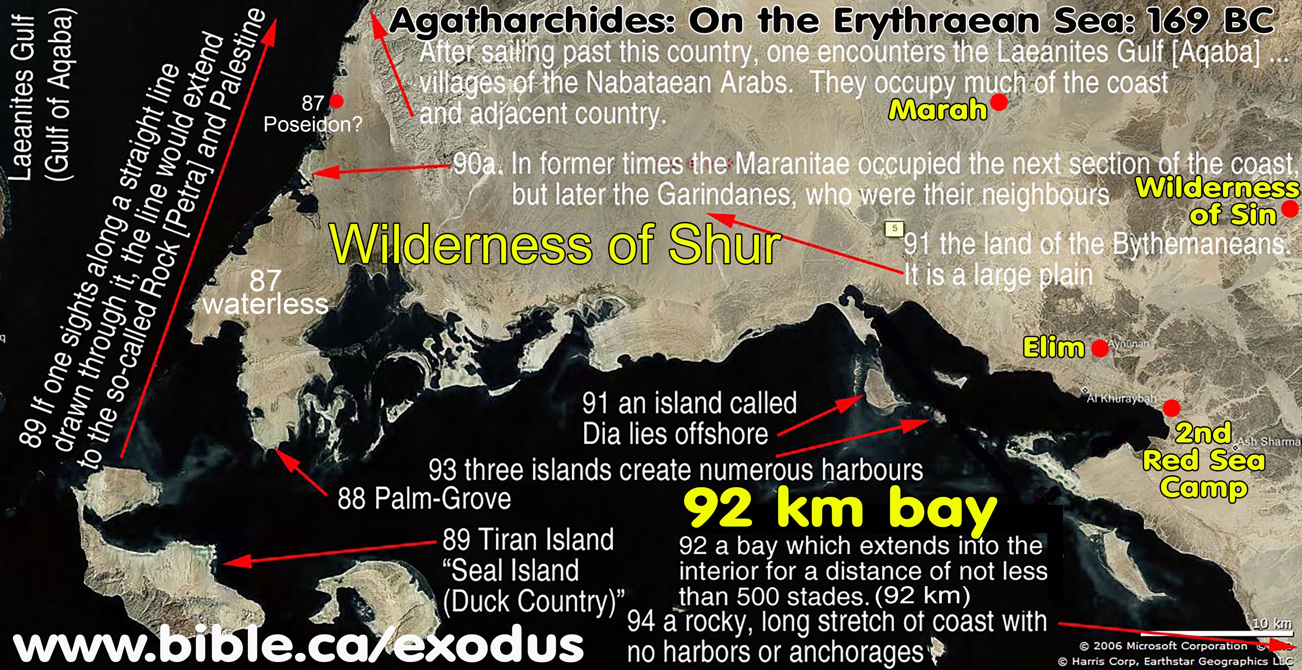
- Agatharchides: 169 BC is unique in that he is one of the few early geographers of his day that understood the Gulf of Aqaba calling it the "Laeanites Gulf".
- He restricts "Arabia" to south and east of the Gulf of Aqaba. Agatharchides did not sail down the Laeanites Gulf, but says the Arabs live on the east/south shore of the Gulf of Aqaba and that at the end of the Gulf, is Petra!
- No Arabians lived in the Sinai Peninsula. As he sails down the Red Sea towards the Indian Ocean, he describes all the various tribes of Arabians.
D. 100 BC Artemidorus says Arabia was south of the Gulf of Aqaba not in the Sinai Peninsula:
MASTER SUMMARY: 100 BC Artemidorus of Ephesus excluded the Sinai Peninsula as Arabian territory and began describing their lands south of the Gulf of Aqaba at Tiran Island (Seal Island). In 16.4.18, Strabo quoted Artemidorus, “After [Artemidorus] said all this about the Troglodytes and the neighbouring Ethiopians, Artemidorus returned to the Arabians; and first, beginning at Poseidium, he describes Arabians who border on the Arabian Gulf and live opposite the Troglodytes [Wilderness of Shur]. He says that Poseidium lies farther in than the Aelanites Gulf [Gulf of Aqaba]; and that contiguous to Poseidium there is a grove of palm trees”. Artemidorus also described the spice trade route where goods were transported through the wilderness of Shur area of Midian to Petra: “the Rock of the Nabataean Arabians [Petra], as they are called, and to the Palaestine country, whither [to Petra] Minaeans and Gerrhaeans and all the neighbouring peoples convey their loads of aromatics [to Petra].” We know from Strabo 16.4.24 that the Midian area in general and seaport of Leuke Kome (Elim, Aynuna) was a major Nabatean centre for the Arabian trade route to Petra then to Rhinocolura then to Greece and Rome.
1. Artemidorus of Ephesus lived about 100 BC and there are no surviving manuscripts of his work. However, several other geographers like Strabo, quote him.
a. Artemidorus first describes the Troglodytes (descendants of Ketura and Abraham) living down the west coast of the Arabian Gulf beside Egypt and Ethiopia. Then Second, Artemidorus describes the “Arabians” [wilderness of Shur, Midian] who live “opposite the Troglodytes” on the eastern shore of the Arabian Gulf starting at the Gulf of Aqaba.
b. Strabo recorded this in AD 15 and this proves that the Sinai Peninsula is not part of Arabia.
c. To both Strabo and Artemidorus, Arabia began south of the Gulf of Aqaba in modern Saudi Arabia.
2. “After saying all this [Artemidorus of Ephesus – 100 BC] about the Troglodytes and the neighbouring Ethiopians, Artemidorus [of Ephesus – 100 BC] returns to the Arabians; and first, beginning at Poseidium, he describes Arabians who border on the Arabian Gulf and live opposite the Troglodytes. He says that Poseidium lies farther in than the Aelanites Gulf [Gulf of Aqaba]; and that contiguous to Poseidium there is a grove of palm trees, which is well supplied with water and is highly valued because all the country around is hot and waterless and shadeless; and that here the fertility of the palms is wonderful; and that a man and a woman have charge of the grove, being appointed to that charge through hereditary right. They wear skins, and live on dates from the palm trees; but on account of the number of wild beasts they build huts in trees and sleep there. Then, next, one comes to the Island of Phocae [Seal Island, Tiran Island], which was so named from the number of seals there. Near the island is a promontory, which extends to the Rock of the Nabataean Arabians [Petra], as they are called, and to the Palaestine country, whither Minaeans and Gerrhaeans and all the neighbouring peoples convey their loads of aromatics.” (Artemidorus of Ephesus, quoted by Strabo in Geography 16.4.18)
E. 30 BC Diodorus Siculus says Petra is the eastern boundary of Arabia
MASTER SUMMARY: 30 BC Diodorus Siculus understood the western boundary of Arabia was the Nabatean kingdom and entirely Transjordan located at Petra, and not in the Sinai Peninsula. Diodorus Siculus in 2:48-49 describes Arabia at Petra and the Salt Sea then describes both Arabia Deserta and Arabia Felix that adjoin the Nabatean kingdom in the Arabian Peninsula.
1. Diodorus Siculus was a Greek historian who lived between 90-30 BC. He understood the western boundary of Arabia was the Nabatean kingdom and entirely Transjordan located at Petra, and not in the Sinai Peninsula. Diodorus Siculus in 2:48-49 describes Arabia Transjordan at Petra and the Salt Sea then describes both Arabia Deserta and Arabia Felix that adjoin the Nabatean kingdom in the Arabian Peninsula.
2. “But now that we have examined these matters we shall turn our account to the other parts of Asia [Syria to Egypt] which have not yet been described, and more especially to Arabia. This land [Asia] is situated between Syria and Egypt, and is divided among many peoples of diverse characteristics. Now the eastern parts [Transjordan] are inhabited by Arabs, who bear the name of Nabataeans and range over a country [Arabia Deserta] which is partly desert and partly waterless, though a small section of it is fruitful. 2 And they lead a life of brigandage [pirates] and overrunning a large part of the neighbouring territory they pillage it, being difficult to overcome in war. For in the waterless region, as it is called [Arabia Deserta], they have dug wells at convenient intervals and have kept the knowledge of them hidden from the peoples of all other nations, and so they retreat in a body into this region out of danger.3 For since they themselves know about the places of hidden water and open them up, they have for their use drinking water in abundance; but such other peoples as pursue them, being in want of a watering-place by reason of their ignorance of the wells, in some cases perish because of the lack of water and in other cases regain their native land in safety only with difficulty and after suffering many ills. 4 Consequently the Arabs who inhabit this country, being difficult to overcome in war, remain always unenslaved; furthermore, they never at any time accept a man of another country as their over-lord and continuous to maintain their liberty unimpaired. 5 Consequently neither the Assyrians of old, nor the kings of the Medes and Persians, nor yet those of the Macedonians have been able to enslave them, and although they led many great forces against them, they never brought their attempts to a successful conclusion. 6 There is also in the land of the Nabataeans a rock [Petra], which is exceedingly strong since it has but one approach, and using this ascent they mount it a few at a time and thus store their possessions in safety. And a large lake [Salt Sea] is also there which produces asphalt in abundance, and from it they derive not a little revenue. … That part of Arabia which borders upon the waterless and desert country [Arabia Deserta south of Petra] is so different from it that, because both of the multitude of fruits which grow therein and of its other good things, it has been called Arabia Felix.” (Diodorus Siculus 2:48-49, 30 BC)
F. 15 BC Marcus Vipsanius Agrippa: Arabia was Arabia Felix:
MASTER SUMMARY: 15 BC Marcus Vipsanius Agrippa followed most contemporary geographers and defined Arabia as Arabia Felix, which never included the Sinai at any point in history. Agrippa created a map of the world just before the Birth of Christ in 2 BC. This map was widely circulated for centuries but none have survived. His cartographic work is referenced no less than 87 times by Pliny in AD 77 and four times by Strabo in AD 15. Agrippa’s Arabia was equal to Arabia Felix and the northern Sinai coastline was considered part of Syria not Arabia. This demonstrates that when contemporary geographers like Strabo would describe Rhinocolura as an “Arabian town” all understood this was not Arabia proper.
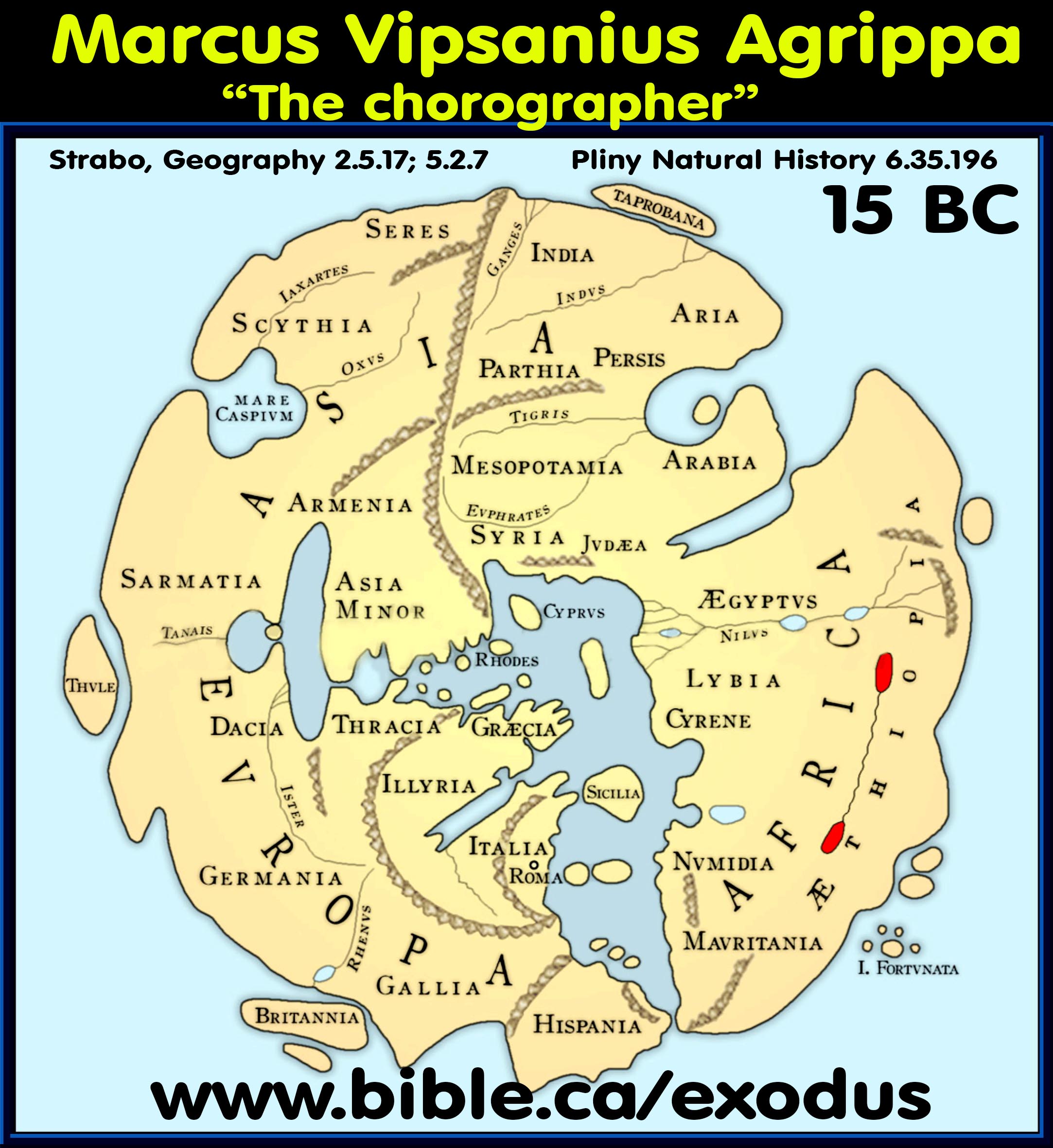
1. Marcus Vipsanius Agrippa created a map of the world just before the Birth of Christ in 2 BC. This map was widely circulated for centuries but none have survived. His cartographic work is referenced no less than 87 times by Pliny in AD 77 and four times by Strabo in AD 15. Agrippa’s Arabia was equal to Arabia Felix and the northern Sinai coastline was considered part of Syria not Arabia. This demonstrates that when contemporary geographers like Strabo would describe Rhinocolura as an “Arabian town” all understood this was not Arabia proper.
a. “Although copies of Agrippa’s map were taken to all of the great cities of the Roman Empire, not a single copy has survived. The reconstructions shown here are based upon data in the medieval world maps that were, in turn, derived from Roman originals, plus textual descriptions by classical geographers such as Strabo, Pomponius Mela and Pliny. The original was made at the command of Agrippa’s father-in-law, the Emperor Augustus (27 B.C. - A.D. 14), and completed in A.D. 20. The map was presumably developed from the Roman road itineraries, and may have been circular in shape, thus differing from the Roman Peutinger Table (#120). Note that most scholars, however, believe that due to its placement on the column in a portico or stoa open to the public, the Porticus Vipsani, it was probably rectangular, not circular. (Marcus Vipsanius Agrippa, Orbis Terrarum, Jim Siebold, monograph #118, p1, 2012 AD)
b. “The map of Agrippa, however, was set up, not in a sacred place, but in a portico or stoa open to the public, the Porticus Vipsania. It was not a map of a part of the Empire, not even a map of the Empire as a whole, but rather a map of the whole known world, of which the Roman Empire was merely one part. We know, therefore, that when Agrippa died in 12 B.C. he had not as yet begun this particular one of his many buildings. (Marcus Vipsanius Agrippa, Orbis Terrarum, Jim Siebold, monograph #118, p6, 2012 AD)
2. Doug Fisher’s alleged discover of the long-lost map of Marcus Vipsanius Agrippa’s “Orbis Terrarum" as antarctica on the bottom of Johannes Schöner’s AD 1515 globe. Fisher suggested that Schöner did not recognize Agrippa’s map as a map of the world and mistakenly thought it was a map of Antarctica.
a. Fisher’s claim fails to explain how the Arabian and Persian Gulfs are non-existent in a time when the Nabatean spice trade routes are at their peak.
b. On Fisher’s “Agrippa map found” the Nile runs east to west between two lakes instead of south to north where it empties into the Mediterranean. Several cartographers before Agrippa correctly drew the Nile.
c. The lateral east-west African waterway (marked in red on the above map) simply cannot represent the Nile. Herodotus fabricated a fictitious phantom gulf he claimed existed 20,000 years earlier between the port of Suez to Alexandria. (Hist. 2.11.3). The east-west lateral waterway is just another nonexistent phantom of mistaken geographical knowledge of the day.
d. The reconstruction map we have provided above is correct, and Fisher’s reconstruction where he make the lateral waterway into the Nile is to be rejected.
e. The conclusion is that while there are some interesting reasons why Schöner’s antarctica might be the long lost Agrippa map from the first century, it is how Schöner viewed the southern hemisphere of ice where nobody had ever explored or understood just how desolate and frozen solid it really was. Fisher’s keen eye is like a person seeing an elephant in the clouds, but it is nothing more than a random coincidence.
3. Strabo never names Marcus Agrippa as a source but calls him the “chorographer” three times and refers once to his map:
a. “The Greek geographer Strabo was in Rome in 7 B.C., or shortly afterwards, and he several times mentions “the chorographer,” “the chorography” and “the chorographic map”. It is now the common view of scholars that these passages refer to Agrippa and to his map. Although Strabo does not mention Agrippa’s name here he is probably merely being tactful with regard to the Emperor who, presumably, took a large part in the completion of the portico with its map. (Marcus Vipsanius Agrippa, Orbis Terrarum, Jim Siebold, monograph #118, p6, 2012 AD)
b. “The chorographer [Marcus Agrippa] says that the length of this island is 160 miles, its breadth 70; that the length of Sardinia is 220, and its breadth 98.” (Strabo, Geography 5.2.7)
c. “Now the chorographer [Marcus Agrippa] reckons that from Ericodes to Phœnicodes are 10 miles, from thence to Didyma 30, from thence to the northernmost point of Lipari 29, and from thence to Sicily 19, while from Strongyle are 16.” (Strabo, Geography 6.2.11)
d. “The chorographer [Marcus Agrippa] says that the shortest passage from Libya to Sardinia is 300 miles.” (Strabo, Geography 5.2.8)
e. “The ocean it is which principally divides the earth into various countries, and moulds its form. It creates bays, seas, straits, isthmuses, peninsulas, and capes; while rivers and mountains serve to the same purpose. It is by these means that continents, nations, and the position of cities are capable of being clearly distinguished, together with those various other details of which a chorographical chart is full [Strabo’s reference to the map of Marcus Vipsanius Agrippa]. Amongst these latter are the multitude of islands scattered throughout the seas, and along every coast; each of them distinguished by some good or bad quality, by certain advantages or disadvantages, due either to nature or to art” (Strabo, Geography 2.5.17)
4. Pliny the Elder references Marcus Agrippa 87 times:
a. “The length of the whole of the territory of the Ethiopians including the Red Sea was estimated by Agrippa as 2170 miles and its breadth including Upper Egypt 1296 miles.” (Pliny Natural History 6.35.196)
5. “Agrippa regarded the Syrian coast running northeast from the boundary of Egypt, as running much more in an easterly direction than it actually does. Therefore, the longitude was to him the eastwest direction, and the latitude from Seleucia Pieria to Zeugma was the north-south direction. Any doubt on this matter is removed when we look at Pliny (VI, 126), where he gives the latitude from the same point, Seleucia Pieria, to the mouth of the Tigris. The distance is 175 miles from Seleucia to Zeugma, 724 miles from Zeugma to Seleucia and Tigrim and 320 miles to the mouth of the Tigris, that is, 1,219 in all. This distance, he adds, is the latitude of the earth between the two seas, that is, the Mediterranean and the Persian Gulf.” (Marcus Vipsanius Agrippa, Orbis Terrarum, Jim Siebold, monograph #118, p17, 2012 AD)
6. “Some, as I have said, state that this country is separated into four divisions; others, into five. It is not easy to state any thing precisely on these points, both on account of the changes which the places have undergone, and by reason of their obscurity. In well-known and notable countries both the migrations are known, and the divisions of the land, and the changes of their names, and every thing else of the same kind. Such matters being the common topics with everybody, and especially with the Greeks, who are more talkative than any other people. But in barbarous and out-of-the-way countries, and such as are cut up into small divisions, and lie scattered, the remembrance of such occurrences is not nearly so certain, nor yet so full. If these countries are far removed from the Greeks [our] ignorance is increased. For although the Roman historians imitate the Greeks, they fall far short of them. What they relate is taken from the Greeks, very little being the result of their own ardour in acquiring information. So that whenever anything has been omitted by the former there is not much supplied by the latter. Add to this, that the names most celebrated are generally Grecian.” (Strabo, Geography 3.4.19)
7. “The profound difference between the Roman and the Greek mind is illustrated with peculiar clarity in their maps. The Romans were indifferent to mathematical geography, with its system of latitudes and longitudes, its astronomical measurements, and its problem of projections. What they wanted was a practical map to be used for military and administrative purposes. Disregarding the elaborate projections of the Greeks, they reverted to the old disk map of the Ionian geographers as being better adapted to their purposes. Within this round frame the Roman cartographers placed the Orbis Terrarum, the circuit of the world.” (Marcus Vipsanius Agrippa, Orbis Terrarum, Jim Siebold, monograph #118, p1, 2012 AD)
8. “From another well-known passage in Strabo (V, 3, 8, C, 235-236) that contains a panegyric [a public speech or published text in praise of someone or something] on the fine buildings of Augustan Rome, we know that he was well acquainted with the dedications of Marcus Agrippa that he specifically mentions. The phrase which he uses of Agrippa’s aqueducts is exactly echoed in Pliny’s phrase tanta diligentia. He was, therefore, well acquainted also with the map or Agrippa to which, or to whose content he refers no less than seven times in his Books II, V and VI. The most important of these passages is the first (II, 5, 17, C 120) where he refers to the important role played by the sea and secondarily, and by rivers and mountains in the shaping of the earth. “The sea is the cause of gulfs, oceans, sounds, isthmuses, peninsulas and promontories. Such features as these brought into existence the continents, the tribes, the fine natural sites of cities and the other decorative features of which our chorogaphic map is chock full.” The Orbis Terrarum #118 13 map of Agrippa displayed, therefore, all the natural features just mentioned and, in addition, the names of tribes and of famous cities.” (Marcus Vipsanius Agrippa, Orbis Terrarum, Jim Siebold, monograph #118, p13, 2012 AD)
9. “Agrippa was a very painstaking man, and also a very careful geographer; who therefore could believe that when intending to set before the eyes of Rome a survey of the world he made a mistake, and with him the late lamented Augustus? for it was Augustus who completed the portico containing a plan of the world that had been begun by his sister in accordance with the design and memoranda of Marcus Agrippa.” (Pliny Natural History 3.2.17)
G. AD 15 Strabo locates Arabia in Saudi Arabia and never the Sinai Peninsula:
MASTER SUMMARY: AD 15: Strabo locates “the whole of Arabia” Transjordan in the Arabian Peninsula (Strabo, Geography 16.3.1; 16.4.1; 17.1.1) and never in the Sinai Peninsula. He also correctly describes the Gulf of Aqaba as pointing towards Arabia whereas the Gulf of Suez as pointing towards Egypt. Strabo 1.2.32 notes that in the time of Homer (c 650 BC), before the Babylonian captivity, that Arabia Felix was small and restricted to the southern end of the Arabian Peninsula but in the first century Strabo 2.5.32; 16.4.21 placed the entire Nabatean kingdom inside Arabia Felix. Leuke Kome and the area around the Wilderness of Shur beside Tiran Island (Seal Island) was Nabatean (Strabo 16.4.18; 16.4.23), which proves first century Arabia included the northwest corner of Saudi Arabia at Midian. Following the pattern of contemporary geographers, Strabo draws a latitudinal line 5600 stadia long (=1036 km, actually 1500 km) between the tip of the Gulf of Suez due east through Petra to the tip of the Persian gulf and sequentially describes three Arabian tribes beginning with the Nabateans at Petra: “Nabataeans and the Chaulotaeans and the Agraeans [Hagarites] (Strabo 16.4.2). This proves there were no Arabian tribes living west of Petra in the Sinai Peninsula. Strabo describes in great detail the Arabian spice trade route through Leuke Kome near Midian through Petra to Rhinocolura (Strabo 16.4.24) and the route through Myos Hormos up the Nile to Alexandria (Strabo 16.4.24; 2.5.12; 16.4.5). Although Rhinocolura was known as an Arabian trade route town, Strabo says it is in “Phoenicia, near Egypt” not Arabia (Strabo 16.4.24). This explains why he describes “Arabian Cities” at key locations inside Egypt at Goshen and on the Nile at the border with Ethiopia (Strabo 2.5.32). Like Herodotus, he calls Goshen Arabia, but the eastern boundary was the Suez Canal and did not extend east into the Sinai Peninsula (Strabo 17.1.21).
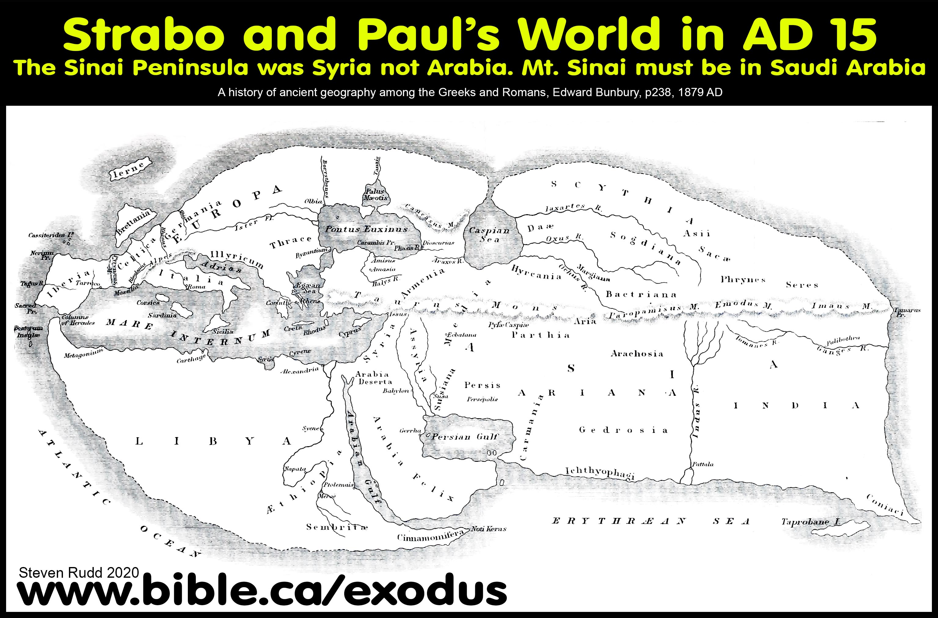
- Strabo’s sources for his definition of Arabia: “In the 16th book, he describes the westerly half of south Asia, viz. Assyria with Babylonia, Mesopotamia, Syria, Phoenicia, and Palestine, the Persian and Arabian Gulfs, the coast of Ethiopia, and lastly, Arabia. For the three first countries (the old Assyrian kingdom), his chief authorities are, besides some of Alexander’s historians, Eratosthenes, Poseidonius, and Herodotus; for the remainder he had, in addition to the same writers, Artemidorus, and probably also Nicolaus of Damascus.” (The Geography of Strabo, H. C. Hamilton, p xvii, 1903 AD)
- Strabo (AD 15) is one of the few ancient cartographers who understood the gulf of Aqaba and gives us great insight into how the Apostle Paul and Josephus viewed the Sinai Peninsula as NOT part of Arabia. He also correctly describes the Gulf of Aqaba as pointing towards Arabia whereas the Gulf of Suez as pointing towards Egypt.
- If the Sinai Peninsula was Arabia, both Gulfs would point towards Arabia. He would also have described Arabia as being on both sides of the Gulf of Aqaba. Furthermore, he would have described how Arabia was above both Gulfs, where Suez pointed towards Egypt and the other pointed towards Nabatea.
- "There is said to be a passage thence across, of 1260 stadia, to the city Aila (Aelana) [Elat], situated on the innermost recess of the Arabian Gulf [Red Sea]. This recess has two branches, one, in the direction of Arabia [south of Gulf of Aqaba] and Gaza [north of Gulf of Aqaba], is called Ailanites [Gulf of Aqaba], from the city upon it; the other is in the direction of Egypt [Gulf of Suez], towards Hereopolis, to which from Pelusium is the shortest road (between the two seas). (Strabo, Geogr. 16.2.30)
- Strabo said that Petra and Nabateans were inside Arabia Felix:
- The Nabateans were one of many Arabian tribes who lived in the large territory of Arabia Felix.
- “The Nabatæans and Sabæans, situated above Syria, are the first people who occupy Arabia Felix. They were frequently in the habit of overrunning this country before the Romans became masters of it, but at present both they and the Syrians are subject to the Romans. The capital of the Nabatæans is called Petra.” (Strabo, Geogr. 16.4.21)
- “Beyond Mesopotamia are the countries on this side the Euphrates; viz. the whole of Arabia Felix, bounded by the entire Arabian and Persian Gulfs, together with the country of the Scenitæ and Phylarchi, who are situated along the Euphrates and in Syria.” (Strabo, Geography 2.5.32)
- “Of the rest of the country which follows after Mesopotamia, and extends as far as Cœle-Syria, the part approaching the river, as well as [a part of] Mesopotamia, are occupied by Arabian Scenitæ [lawless pirate nomads], who are divided into small sovereignties, and inhabit tracts which are barren from want of water. They do not till the land at all, or only to a small extent, but they keep herds of cattle of all kinds, particularly of camels. Above these is a great desert [Arabia Deserta]; but the parts lying still more to the south [Arabia Felix] are occupied by the nations inhabiting Arabia Felix, as it is called. The northern side of this tract is formed by the above-mentioned desert, the eastern by the Persian, the western by the Arabian Gulf, and the southern by the great sea lying outside of both the gulfs, the whole of which is called the Erythræan (Red) Sea.” (Strabo, Geography 16.3.1)
- Strabo describes Tiran Island as “Seal Island” and the Gulf of Aqaba that extends north to Petra: “Next is the island of Phocæ (Seals) [Tiran Island], which has its name from those animals, which abound there. Near it is a promontory [Gulf of Aqaba], which extends towards Petra, of the Arabians called Nabatæi, and to the country of Palestine, to this [island] the Minæi, Gerrhæi, and all the neighbouring nations repair with loads of aromatics. … Next is the Ælanitic Gulf [Gulf of Aqaba] and Nabatæa, a country well peopled, and abounding in cattle.” (Strabo, Geogr. 16.4.18)
- Strabo notes that in the time of Homer (c 650 BC), before the Babylonian captivity, that Arabia Felix was small and restricted to the southern end of the Arabian Peninsula.
- The Edomites went extinct around 550 BC as the Arabians move north and took over their territory and began to inhabit Petra.
- “And though he [Homer] knew of the Arabia which is now named Felix, at that time it was by no means wealthy, but a wild country, the inhabitants of which dwelt for the most part in tents. It is only a small district which produces the aromatics from which the whole territory afterwards received its name [Arabia Felix], owing to the rarity of the commodity amongst us, and the value set upon it. That the Arabians are now flourishing and wealthy is due to their vast and extended traffic, but formerly it does not appear to have been considerable. A merchant or camel-driver might attain to opulence by the sale of these aromatics and similar commodities; but Menelaus could only become so either by plunder, or presents conferred on him by kings and nobles, who had the means at their disposal, and wished to gratify one so distinguished by glory and renown. The Egyptians, it is true, and the neighbouring Ethiopians and Arabians, were not so entirely destitute of the luxuries of civilization.” (Strabo, Geography 1.2.32)
- Strabo defines “the whole of Arabia” as being Transjordan:
- "Above [ie to the east: East-up map] Judæa and Cœle-Syria, as far as Babylonia and the river tract, along the banks of the Euphrates towards the south, lies the whole of Arabia" (Strabo, Geography 16.3.1)
- "When we were describing Arabia, we included in the description the gulfs which compress and make it a peninsula, namely the Gulfs of Arabia [section below the tri-intersection of the Gulfs of Suez, Aqaba and Arabia] and of Persis [Persian gulf near Babylon]. (Strabo, Geography 17.1.1)
- “Arabia commences on the side of Babylonia with Maecenê. In front of Maecenê, on one side, lies the desert of the Arabians; and on another side lie the marshes opposite the Chaldaeans, which are formed by diversions of water from the Euphrates; and on another side lies the Persian Sea. The country has foul air, is misty, and is subject both to rains and to scorching heat; but still its products are excellent. The vine grows in the marshes, as much earth being thrown on hurdles of reeds as the plant may require; so that the vine is often carried away, and then is pushed back again to its proper place by means of poles.” (Strabo, Geography 16.4.1)
- Following the pattern of contemporary geographers, Strabo draws a latitudinal line 5600 stadia long (=1036 km, actually 1500 km) between the tip of the Gulf of Suez due east through Petra to the tip of the Persian gulf and sequentially describes three Arabian tribes beginning with the Nabateans at Petra. This proves there were no Arabian tribes living west of Petra in the Sinai Peninsula. “But I return to Eratosthenes, who next sets forth his opinions concerning Arabia. He says concerning the northerly, or desert, part of Arabia, which lies between Arabia Felix and Coelê-Syria and Judaea, extending as far as the recess of the Arabian Gulf, that from the City of Heroes [Heroönpolis], which forms a recess of the Arabian Gulf near the Nile, the distance in the direction of the Petra of the Nabataeans to Babylon is five thousand six hundred stadia, the whole of the journey being in the direction of the summer sunrise [east-west] and through the adjacent countries of the Arabian tribes, I mean the Nabataeans and the Chaulotaeans and the Agraeans [Hagarites]. Above these lies Arabia Felix, which extends for a distance of twelve thousand stadia towards the south, to the Atlantic Sea. The first people who occupy Arabia Felix, after the Syrians and Judaeans, are farmers. After these the soil is sandy and barren, producing a few palm-trees and a thorny tree [Mimosa Nilotica] and the tamarisk, and affording water by digging, as is the case in Gedrosia; and it is occupied by tent-dwellers and camel-herds. The extreme parts towards the south, lying opposite to Aethiopia, are watered by summer rains and are sowed twice, like India; and the rivers there are used up in supplying plains and lakes. The country is in general fertile, and abounds in particular with places for making honey; and, with the exception of horses and mules and hogs, it has an abundance of domesticated animals; and, with the exception of geese and chickens, has all kinds of birds. The extreme part of the country above-mentioned is occupied by the four largest tribes; by the Minaeans, on the side towards the Red Sea, whose largest city is Carna or Carnana; next to these, by the Sabaeans, whose metropolis is Mariaba [Marib]; third, by Cattabanians, whose territory extends down to the straits and the passage across the Arabian Gulf, and whose royal seat is called Tamna; and, farthest toward the east, the Chatramotitae, whose city is Sabata [Also spelled Sabattha; now Sawa]”. (Strabo, Geography 16.4.2)
- Dionysius of Alexandria (AD 124) lists the same three Arabian tribes of Nabataei, Chaulasii, Agrei [Hagarites] beside Syria as Strabo in Geography 16.4.2. This confirms Strabo also viewed Arabia as equal to Arabia Felix and not in the Sinai Peninsula.
- The Sinai is not Arabia because cinnamon, nard, and other aromatics are never grown there:
- “Southern India, like Arabia and Ethiopia, produces cinnamon, nard, and other aromatics.” (Strabo, Geogr. 15.1.22)
- “According to Nearchus, the sea-coast of Susis is swampy, and terminates at the river Euphrates; at its mouth is a village, which receives the merchandise from Arabia; for the coast of Arabia approaches close to the mouths of the Euphrates and the Pasitigris; the whole intermediate space is occupied by a lake which receives the Tigris.” (Strabo, Geography 15.3.5)
- Strabo assigns the territory of the Troglodytes (Cave Dwellers) on the western coast of the Arabian Gulf beside Egypt and Ethiopia from the Gulf of Aqaba to the south. In 1.2.34, Strabo calls the Troglodytes “Arabs”.
- “Perhaps this [last] term is that by which the Greeks anciently designated the Arabs; the etymon of the word certainly strengthens the idea. Many deduce the etymology of the Erembi from ἔραν ἐμαίνειν, (to go into the earth,) which [they say] was altered by the people of a later generation into the more intelligible name of Troglodytes [cave dwellers], by which are intended those Arabs who dwell on that side of the Arabian Gulf next to Egypt and Ethiopia.” (Strabo, Geography 1.2.34)
b. “The Troglodytica extended along the western side of the Arabian Gulf, from about the 19th degree of latitude to beyond the strait. According to Pliny, vi. c. 34, Sesostris conducted his army as far as the promontory Mossylicus, which I think is Cape Mete of the modern kingdom of Adel. Gossellin.” (Strabo, The Geography of Strabo, H. C. Hamilton, Strabo, Geography 16.4.4 p191, fn 5005, 1903 AD)
- Strabo describes a population of Arabians living west of the Arabian Gulf and on the Nile south of Elephantine/Aswan.
- “Beyond the Arabian Gulf and as far as the Nile dwell the Ethiopians and Arabians, and next these the Egyptians, Syrians, and Cilicians, both those styled Trachiotæ and others besides, and last of all the Pamphylians.” (Strabo, Geography 2.5.32)
- Strabo defines ancient Goshen as Arabia:
- “The country between the Nile and the Arabian Gulf is Arabia, and at its extremity is situated Pelusium.” (Strabo, Geography 17.1.21)
- Strabo describes Goshen as between the Nile and the Gulf of Suez. Strabo does not say that Goshen is all the land east of the Nile to Judea, but marks the eastern boundary of Goshen at the Gulf of Suez. This follows the translators of the Septuagint in 282 BC who also called ancient Goshen, “Arabia”. This is because of the large population of Arabs who lived there. Many major cities today have large populations of Chinese called “Chinatown”, but it is understood to be the USA, not China. Likewise, Goshen was called Arabia in the same sense of “Arabtown”. The Hebrews living in Goshen during the 430-year captivity controlled the final caravan terminal at the end of the Philistine highway that went up the coast through Gaza and Tyre. The Arabs had moved into ancient Goshen to control not only the caravan routes themselves, but also the end terminals were goods would be unloaded from the camels. There were a series of seaports also occupied by the Arabs south of Gaza that included Arish. The Sinai was not considered Arabia because the Arabs controlled the final shipping ports.
- Strabo and Josephus describe the forced conversion of the Nabateans including Herod the Great by Hyrcanus in 129 BC. The Nabatean cities south of Beersheba were circumcised proselytes: Elusa, Ruheiba, Sobata, Nessana, Advat/Oboda and Mampsis/Kurnub. This proves that these Nabatean cities located in the Judean Negev were not part of Arabia or controlled by the King at Petra, but were vassal cities under the Maccabeans. With the rise of the Roman Empire, the Nabateans were subject to Rome during the entire first century as a vassal kingdom at Petra.
- “The Idumæans are Nabatæans. When driven from their country by sedition, they passed over to the Jews, and adopted their customs. (Strabo, Geogr. 16.2.34)
- “Hyrcanus took also Dora and Marissa [Mareshah beside Beth-guvrin], cities of Idumea, and subdued all the Idumeans; and permitted them to stay in that country, if they would circumcise their genitals, and make use of the laws of the Jews; (258) and they were so desirous of living in the country of their forefathers, that they submitted to the use of circumcision, and the rest of the Jewish ways of living; at which time therefore this befell them, that they were hereafter no other than Jews.” (Josephus Antiquities 13.257–258)
- “The Nabatæans and Sabæans, situated above Syria, are the first people who occupy Arabia Felix. They were frequently in the habit of overrunning this country before the Romans became masters of it, but at present both they and the Syrians are subject to the Romans. The capital of the Nabatæans is called Petra.” (Strabo, Geogr. 16.4.21)
- Arabian trade route to Egypt: Myos Hormos to Coptus to Nile to Alexandria:
a. “Merchandise is conveyed from Leuce-Come to Petra, thence to Rhinocolura in Phœnicia, near Egypt, and thence to other nations. But at present the greater part is transported by the Nile to Alexandrea. It is brought down from Arabia and India to Myos Hormos, it is then conveyed on camels to Coptus of the Thebais [region], situated on a canal of the Nile, and to Alexandria.” (Strabo, Geography 16.4.24)
- “The entrance of a Roman army into Arabia Felix under the command of my friend and companion Ælius Gallus,and the traffic of the Alexandrian merchants whose vessels pass up the Nile and Arabian Gulf to India, have rendered us much better acquainted with these countries than our predecessors were. I was with Gallus at the time he was prefect of Egypt, and accompanied him as far as Syene and the frontiers of Ethiopia, and I found that about one hundred and twenty ships sail from Myos-hormos to India, although, in the time of the Ptolemies, scarcely any one would venture on this voyage and the commerce with the Indies.” (Strabo, Geography 2.5.12)
b. “Artemidorus [of Ephesus – 100 BC] says, that the promontory of Arabia, opposite to Deire, is called Acila, and that the persons who live near Deire deprive themselves of the prepuce [circumcision]. In sailing from Heroopolis along Troglodytica (west coast of Arabian Gulf), a city is met with called Philotera, after the sister of the second Ptolemy; it was founded by Satyrus, who was sent to explore the hunting-ground for the elephants, and Troglodytica itself. Next to this is another city, Arsinoe; and next to this, springs of hot water, which are salt and bitter; they are precipitated from a high rock, and discharge themselves into the sea. There is in a plain near (these springs) a mountain, which is of a red colour like minium. Next is Myos Hormos, which is also called Aphrodites Hormus; it is a large harbour with an oblique entrance. In front are three islands; two are covered with olive trees, and' one (the third) is less shaded with trees, and abounds with guinea-fowls. Then follows Acathartus (or Foul Bay), which, like Myos Hormos, is in the latitude of the Thebais [region]. The bay is really foul, for it is very dangerous from rocks (some of which are covered by the sea, others rise to the surface), as also from almost constant and furious tempests. At the bottom of the bay is situated the city Berenice.” (Strabo, Geography 16.4.5)
- Arabian trade
route to Greece and Rome: Leuce-Come to Petra to Rhinocolura:
a. “Merchandise is conveyed from Leuce-Come [Elim, Aynuna] to Petra, thence to Rhinocolura [Arish] in Phœnicia, near Egypt, and thence to other nations. But at present the greater part is transported by the Nile to Alexandrea. It is brought down from Arabia and India to Myos Hormos, it is then conveyed on camels to Coptus of the Thebais [region], situated on a canal of the Nile, and to Alexandria.” (Strabo, Geography 16.4.24)
- Strabo 16.4.24 calls Rhinocolura part of Phoenicia not Egypt or Arabia: “Rhinocolura [Arish] in Phoenicia, near Egypt” (Strabo, Geography 16.4.24)
- In AD 50 the Periplus Maris Erythraei described how goods were transported from Arabia to the port city of Leuke Kome, (White Village) which is the Biblical Elim at Ain Ounah. A 25% tax was levied by the local Nabateans and the goods were then transported overland by camels to Petra then to Rhinocolura (Arish).
c. “Now to the left of Berenice, sailing for two or three days from Mussel Harbor [Myos Hormos] eastward across the adjacent gulf, there is another harbor and fortified place [military fortress], which is called White Village [Greek = Leuke Kome], from which there is a road to Petra, which is subject to Malichas, King of the Nabateans. It holds the position of a market-town for the small vessels sent there from Arabia; and so a centurion is stationed there as a collector of one-fourth of the merchandise imported, with an armed force, as a garrison. 20. Directly below this place is the adjoining country of Arabia, in its length bordering a great distance on the Erythraean Sea.” (Periplus Maris Erythraei 19-20, 50 AD)
- Strabo said Leuke Kome (Aynuna) near Midian and Tiran Island was in Nabatean territory:
- “Next is the island of Phocæ (Seals) [Tiran Island], which has its name from those animals, which abound there. Near it is a promontory, which extends towards Petra, of the Arabians called Nabatæi, and to the country of Palestine, to this [island] the Minæi, Gerrhæi, and all the neighbouring nations repair with loads of aromatics. … Next is the Ælanitic Gulf [Gulf of Aqaba] and Nabatæa, a country well peopled, and abounding in cattle.” (Strabo, Geogr. 16.4.18)
b. Strabo describes how Gallus took 15 days to travel by ship from Arsinoe (Port of Suez) to Elim (Leuke Kome, Aynuna): “Gallus, notwithstanding, built not less than eighty biremes and triremes and galleys (phaseli) at Cleopatris, near the old canal which leads from the Nile. When he discovered his mistake, he constructed a hundred and thirty vessels of burden, in which he embarked with about ten thousand infantry, collected from Egypt, consisting of Romans and allies, among whom were five hundred Jews and a thousand Nabatæans, under the command of Syllæus. After enduring great hardships and distress, he arrived on the fifteenth day at Leuce-Come [Leuke Kome], a large mart in the territory of the Nabatæans, with the loss of many of his vessels, some with all their crews, in consequence of the difficulty of the navigation, but by no opposition from an enemy.” (Strabo, Geogr. 16.4.23)
c. Ptolemy’s “Onne” is Strabo’s Leuke Kome: “Eudaimon Arabia [Arabia Felix] is bounded on the north by the designated border of Arabia Petraia [Arabia Petra] and of Arabia Deserta; on the northeast by a part of the Persian gulf; on the west by the Arabian gulf; on the south by the Red Sea; on the east by that part of the Persian gulf and the sea, which extends from the entrance to this gulf as far as the Syagros promontory. The [north-west] coast of this region is as follows: after the border of the Arabian gulf in the inmost part of the Elanite gulf [Gulf of Aqaba], Onne 66°20' [Leuke Kome]. 28°50'; Modiana or Modouna [Not same as Midian, but south of Onne on coast] 66°40' . 27°45'” (Claudius Ptolemy, Geography 6.7.1-2, translated by Brady Kiesling, 150 AD)
14. Archaeology of Leuke
Kome, the seaport of Petra:
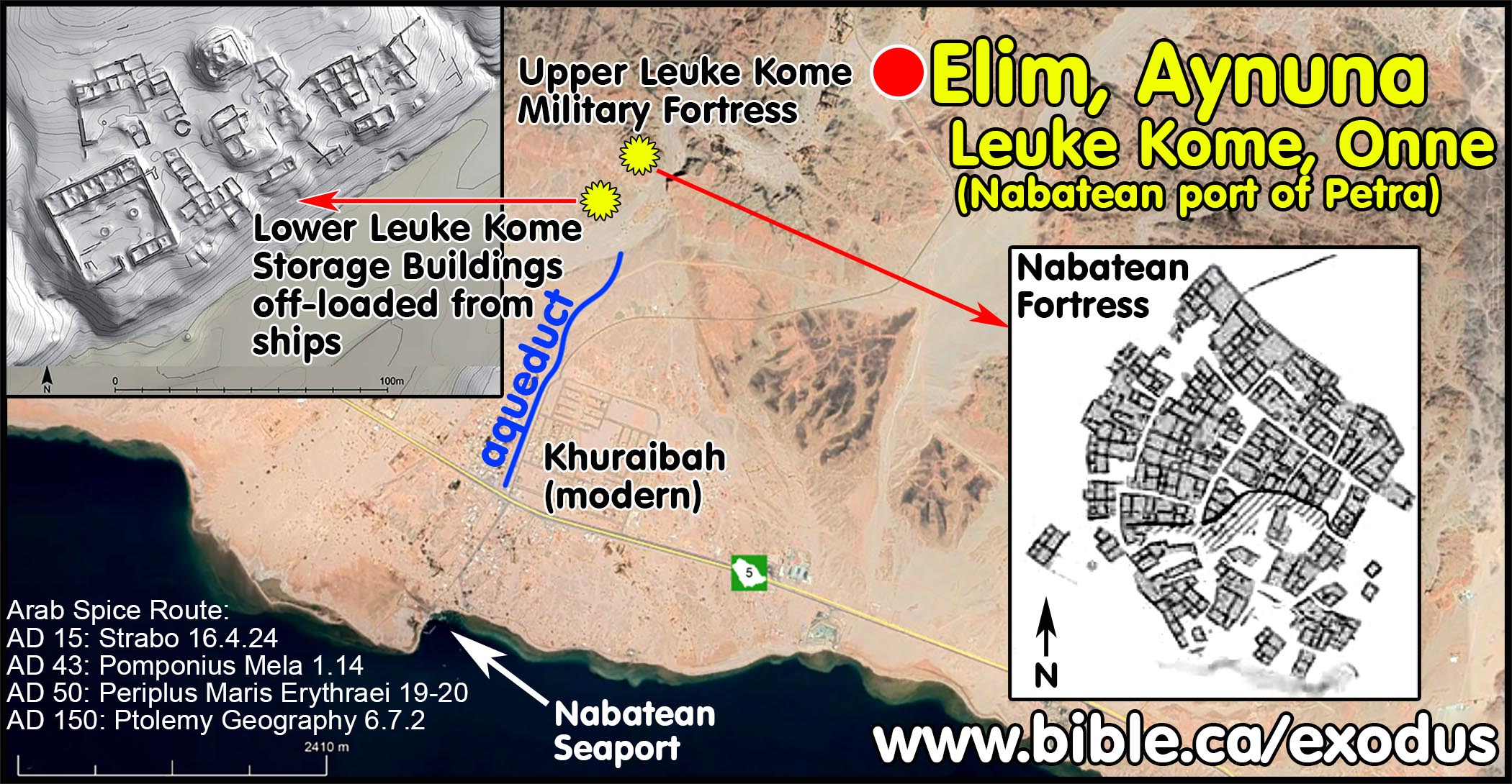
a. In the Exodus, Elim is the same location as Nabatean Leuke Kome and modern Ain Ounah (Aynuna).
b. “Archaeologically Leuke Kome has been identified as a cluster of seven inter-related settlements in the region of Aynuna in Saudi Arabia, c. 5 km from the coast at the mouth of the Gulf of Aqaba (Ingraham et al. 1981: 76–8). Although known only through survey, extensive architecture is visible at two of the complexes, including a standing tower; nearby is a large necropolis. It seems that during the first century AD there was some decline in the use of Leuke Kome as a result of the ascendancy of the Egyptian maritime routes, but that it continued to play a role in the still robust overland trade (Young 2001: 100, 103–4). Leuke Kome is described in the mid-third-century Monumentum Adulitanum (Chapter 4, 88–9), which implies that it was still active at that time as part of Provincia Arabia. A reference by Marcianus may extend the occupation until AD 400 (Ward 2002: 115). Surface pottery from Aynuna included Nabataean wares (Ingraham et al. 1981: pls 82, 86), but no Egyptian or Eastern ones can be identified from the literature. Petra, the capital of Nabataea and an important caravan site, has, on the other hand, been intensively excavated and published. To date, Gogte (1999) has identified a mould-decorated pot similar to Hellenistic ones, like those made in western India (Begley 1992: 157–76). There is a potential for the recovery of further Indian and Arabian finds from these sites, which will help to clarify their role on the wider maritime stage.” (Indo-Roman Trade: From Pots to Pepper, Roberta Tomber, p68, 2012 AD)
c. “A very preliminary analysis of the pre-Islamic ruins in Wadi Aynuna leads to the conclusion that the cluster of buildings in Lower Aynuna [Elim, Leuke Kome] functioned as a storage facility for goods brought to the port at Khoraiba by ship. Once on shore, they were transported by camel caravans to Aila/Aqaba and then to Petra. Still, there are issues to be considered. Why should a storage facility be located 3 km away from the port and why in the first place goods would have been stored there instead of being shipped on smaller vessels further north to the port of Aqaba? Accessibility of water and pastures for camels is the simplest answer to the first question. Both were easily available in the valley of Aynuna and the caravan station would have been located halfway between the port and the camel pastures. Moreover, the site was protected by the nearby settlement in Upper Aynuna. Regarding the second issue, two factors come into play: time and risk. Sailing conditions in the Gulf of Aqaba, with the sudden gales that could last for days, coupled with treacherous reef-lined shores made the journey fraught with danger. In 1833, it took the British ship SS. Palinurus under Captain Robert Moresby six days to sail from the mouth of the Gulf to Aqaba and that only on the second try. Moresby spent four years charting the northern part of the Red Sea for the East India Company and he had no doubt that the Gulf of Aqaba was dangerous to sail. Lateen/settee rigged vessels, known probably as early as the 2nd century AD (Whitewright 2009: 102) were capable of sailing even in such a narrow stretch of sea, although it might have been regarded as risky and time consuming. The inland trade route through Wadi ‘Ifal cut by half the time to reach Petra and was perfectly safe. Decisions in this regard would have been business-driven and safety-oriented for sure. Sailing all the way to Aqaba is another issue to be considered. The Periplus, whether by mere chance or not, speaks of Leuke Kome and not Aqaba/Aila, which is clearly the port of Petra. Aqaba/Aila is not even mentioned there. It seems to have been of minor importance for international trade, possibly because of the risky location in terms of navigation. Aynuna/Khoreiba however was the last safe point on the way from the south, still ensuring fairly comfortable sailing conditions. The real challenge started in the Tiran Strait. The port of Aynuna with its excellent anchorage and its safe and easy connection via an inland route to the rest of the Nabatean kingdom, allowed this dangerous stage of the voyage to be avoided. Modern accounts of sailing conditions in the Gulf of Aqaba indicate that caravans could reach Petra in half the time and without any additional risk. Identifying Leuke Kome has been the topic of numerous scientific discourses and it is beyond the scope of this paper to study the pros and cons of all the diverse views and arguments. What should be pointed out in this context is the topographical question. Generally speaking, two locations of Leuke Kome are considered: Aynuna and El Wajh. The most important source for Red Sea topography is definitely the Periplus Maris Erythraei where Leuke Kome is clearly described as the “port of Petra”. There would be no reason for merchants to stop in El Wajh and take a roundabout route through the Hegra, which incidentally is not mentioned at all, to reach Petra, when Aynuna offers a good and safe anchorage, and an excellent connection with the capital of the Nabateans. The only advantage of El Wajh, and a contested one at that, is its situation opposite Qusair/Myos Hormos, corresponding thus to the description in the Periplus, which says that Leuke Kome is to the east of this port. However, while the Periplus seems to be quite accurate in its descriptions, it shows a surprising generality in the case of Leuke Kome: an approximate distance (“two or three days sailing”) and not very exact directions (“to the left of Berenike”). Moreover, there is no mention of the goods that were traded in this port, a component usually present in descriptions of other ports. It has been recently argued that the author of the Periplus had never been in Leuke Kome personally, making his description of the harbor unreliable at best (Bukharin 2012: 110–124). No material indicating Nabatean presence in El Wajh has been recorded so far, while the temple at Wadi Hamd, found by Burton, is too far away ("one long or two short marches", Burton 1879: 220 ) to be linked with the port and was rather part of the main route connecting this part of the coast with Al Hijr (ancient Hegra, modern Mada’in Saleh), an important Nabatean city in the interior. The author of the Periplus expectedly did not mention Hegra as it would have been a major land stop on the way to Petra. The subordinate route from El Wajh went 50 km south before turning east–northeast toward the desert city. The location of Aynuna on the contrary suits most of the topographical directions regarding Leuke Kome in the Periplus and given by Strabo (Gawlikowski forthcoming). The safe anchorage and the convenient land connection with Petra make Aynuna a strong contender for identification with ancient Leuke Kome. (The port of Aynuna in the pre-Islamic period: nautical and topographical considerations on the location of Leuke Kome, Karol Juchniewicz, Polish archaeology in the Mediterranean, p38, 2018 AD)
H. AD 43: Pomponius Mela “Arabia” is between the Persian and Arabian Gulfs with Arab port cities:
MASTER SUMMARY: AD 43: Pomponius Mela. Pomponius Mela was a Roman geographer contemporary with Strabo and Paul who wrote his “De Chorographia” shortly after AD 43. He described Arabia Felix as being Transjordan between the Persian and Arabian Gulfs (Mela 3.79-80). Although Pomponius Mela never references the Nabateans or Petra, he correctly noted the Nabatean controlled spice trade traffic through Rhinocolura and “Port Azotus [Ashdod] as a trading place for their own ware” (Mela 1.14; 1.60-63). Other geographers note this same Arabian trade route through Rhinocolura that originated from Leuke Kome near Midian via Petra. He described Arabia as a “narrow coastline … at the bend” of the Mediterranean Sea centered at the Nabatean controlled seaport city of Arish/Rhinocolura that included Ashdod to the north (Mela 1.14). He says, “It is Palestine at the point where Syria abuts the Arabs, then Phoenicia [then Egypt]” (Mela 1.63) but he is again describing how the Arabs controlled a few key costal port cities and he does not extend “Arabia” outside of these cities to the south into the Sinai Peninsula. Mela sequences the nations from the Nile eastward up the coast beginning with Egypt at Mt. Casius, then Syria between Mt. Casius and Rhinocolura (Arish), then Arabia from Rhinocolura to Ashdod, then Syria again north of Ashdod (Mela 1.60-63). His sequence of Egypt/Pelusium, Syrian, Arabian, Syrian up the seacoast proves the Sinai Peninsula itself was not Arabia. This destroys the fiction that Arabia began directly east of the Nile to include the entire Sinai Peninsula. It is noteworthy that Pomponius Mela describes Port Azotus (Ashdod) as being an Arabian seaport (Mela 1.61), but then says Gaza to the south is in Palestine (Mela 1.64). This underscores his methodology of describing individual cities with large populations of Arabs as Arabia, even though it was not considered to be Arabia proper. This proves that ancient geographers all understood that Arabia proper was Transjordan but described these seaports as Arabian, simply because they were controlled by Arabs. While he calls a narrow coastline between Rhinocolura and Ashdod “Arabia” Pomponius Mela never called the central or southern Sinai Peninsula “Arabia”.
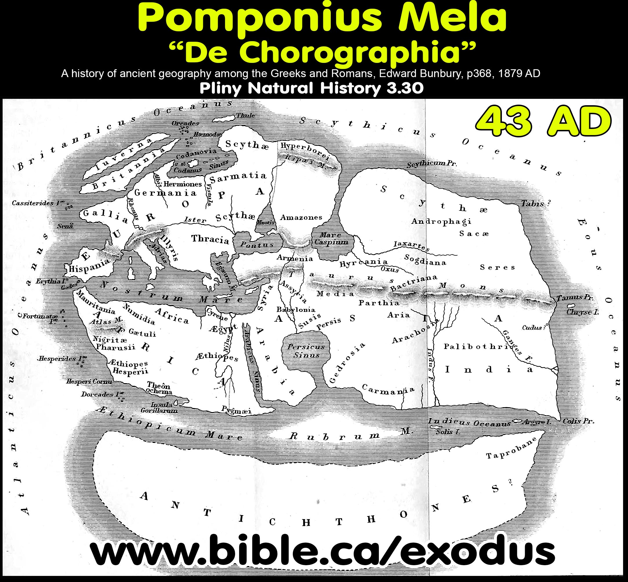
a. “The first-century author Pomponius Mela enjoyed a long- standing reputation in geographical matters, given Pliny’s praise of him in the Natural History. But no text by Mela was known until the 1330s, when Petrarch discovered his De chorographia [On Chorography, or Descriptive Geography] in Avignon. Mela did not include a map in his text.” (Pomponius Mela’s World Map, Jim Siebold, monograph #116, p1, 2012 AD)
b. “Pomponius Mela followed the old Ionian tradition where he inaccurately uses the Nile as the boundaries between Africa to the west and Arabia to the east. “See M. 1.49 and Pliny HN 5.38: the Catabathmos Valley is considered to be in Cyrenaica, and the Nile is considered the eastern border of continental Africa (cp. also 1.8, 1.20, and 1.22, on the Nile as the boundary of Africa). The view that the Nile is the continental border reflects an old Ionian tradition (see Silberman 1988, 128 n. 7), but Strabo (1.2.25-26) argues that Egypt lies on both sides of the Nile and that the eastern border of Africa is the Red (Arabian) Sea. According to Manilius (Astronomica 4.627) the Nile bounds Asia and Africa. See also M. 1.60; cp. Pliny HN 3.3, 5.62.” (Pomponius Mela's description of the world, F.E. Romer, p46, fn 39 on 1.40, 1998 AD)
2. Dating Pomponius Mela’s De Chorographia to AD 43:
a. “The argument can be taken a little further. Claudius was absent from Rome for between five and six months while he took command in the invasion of Britain, and the triumph was held in February 44 C.E. Yet Mela says that the invasion was completed and that the emperor was then on his way to Rome to celebrate the triumph. If time is allotted for conducting the invasion and for the news to reach Rome, the evidence suggests that Mela published his little book very late in 43 C.E. or very early in 44. The air of expectation surrounding Claudius' imminent triumph also suggests that Mela was in Rome when he was writing.” (Pomponius Mela's Description of The World, F.E. Romer, p3, 1998 AD)
b. “Mela provides only two items of personal information about himself. First, in a listing of the coastal cities of Hispania Baetica, he blurts out that his hometown, Tingentera, is located in that region. Later Mela gives an indication of his own date when he refers to the current princeps and to the impending celebration of a formal Roman triumph over the British peoples. … The reference to the princeps and to his impending triumph for his British victory indicates that at that time either Caligula (princeps in 37-41 C.E.) or Claudius (princeps in 41-54 C.E.) was in power, with probability pointing to the latter. Caligula's supposed invasion of Britain has left a trail of fact and fiction in the ancient sources, and the modern researcher is hard-pressed to see what really took place. After planning an invasion of the island, however, Caligula probably delayed his own operation until too late. He also had planned an enormous triumph to celebrate his conquests in the north generally, including his victory over Britain, but he never celebrated a full-scale triumphus, because he never completed his work in the north.3 Instead, Caligula made only a preliminary celebration and commemorated his less sweeping accomplishments with the lesser triumph that the Romans called an ovation (ovatio). Claudius, in contrast, did invade Britain in 43 C.E. and marked his success with a formal triumph in the following year. Mela's remarks (3.49) are vivid and convey an air of reality and authority that Caligula's erratic behavior did not deserve.” (Pomponius Mela's Description Of The World, F.E. Romer, p2, 1998 AD)
c. “Next, as to what kind of place Britain is and what kind of people it produces, information that is more certain and better established will be stated. The reason is that-lo and behold!-the greatest princeps is opening the long-closed island, and as conqueror of previously unsubdued and previously unknown peoples, the princeps brings with him the proof of his own accomplishments, since he will reveal in his triumph as much as he has laid claim to in war.” (Pomponius Mela, De Chorographia, 3:49, AD 43)
3. Arabia Felix is Transjordan in the Arabia Peninsula:
a. Pomponius Mela describes the cities inside Egyptian territory down the western shore of the Arabian Gulf in Egypt to the border with Ethiopia and does not define any part of it as Arabia, even though he said in 3.80 that Arabians inhabit both sides of the Arabian Gulf.
b. “A stretch of land that runs between both seas [Arabian Gulf and Indian ocean] surrounds the other shore of the Persian Gulf. It is called Arabia Eudaemon [Arabia Felix], and it is narrow but very productive of cinnamon, incense, and other scents. The Sabaeans occupy the greater part of it, the Macae the part nearest the mouth [Straits of Hormuz] and across from the Carmanii. Forests and cliffs roughen the seafront between the mouths of the two gulfs. A number of islands are located in the middle region of this gulf [Arabian], but Ogyris is more famous than all the others because the funerary monument of King Erythras is on it. 80. The Arabs surround the second gulf [Arabian Gulf] on all sides. On the right [Arabian Peninsula, and [sequential] in order for anyone who enters the gulf [via the Indian Ocean], are the cities of Charra, Arabia, and Adanus [Aden]; on the other side [African/Egyptian side of Arabian Gulf], from the reentrant angle, the first Berenice, between the Bay of Heroopolis and the Bay of Strobilus; then, between Point Maenorenon and Point Coloba, Philoteris and Ptolemais; farther on, Arsinoe and the other Berenice; then a forest that produces the ebony tree and perfumes; and then a man-made river [Darius I Suez Canal from Nile to Gulf of Suez?], which is worth reporting because it is drawn from the Nile in a canal. (Pomponius Mela 3.79-80, 43 AD)
4. Pomponius Mela describes the Arabian trade route from Leuke Kome to Petra to Rhinocolura:
a. He describes short, narrow strip of shoreline centered at Rhinocolura which was the main exit port for goods to be shipped to Rome and Greece.
b. Pomponius Mela restricts “Arabia” to this narrow strip of coast and does not include any of the Sinai Peninsula.
c. “The Egyptians likewise possess the lands adjacent to the banks of the Nile River and Our Sea (Mediterranean). Then Arabia, with its narrow coastline, is contiguous with the shores that follow. From there, as far as that bend we described above, is Syria. On that very bend is Cilicia, but, in addition, Lyda and Pamphylia, Caria, Ionia, Aeolis, and the Troad all the way up to the Hellespont. From there the Bithynians are found up to the Thracian Bosphorus.” (Pomponius Mela 1.14, De Chorographia, 43 AD)
5. Pomponius Mela says that Gaza is part of Palestine (Philistia) not Arabia but then says Ashdod is a Nabatean city:
a. “On the coast is Alexandria, bordering on Africa, and Pelusium, which borders on Arabia. The mouths of the Nile-the Canopic, Bolbitic, Sebennytic, Pathmetic, Mendesian, Cataptystic, and Pelusiac mouths-cut into those very shores. 61. From here Arabia reaches to the Red Sea [Arabian Sea], but on the far side, being richer and more productive, it abounds in incense and perfumes. On this side, except where it is heightened by Mt. Casius [El Kas, beside Lake Serbonis], Arabia is flat and barren and admits Port Azotus [Ashdod] as a trading place for their own wares. On this side Arabia rises to a great height, being so elevated that, from the mountaintop, sunrise is visible from the fourth watch on. 62. Syria holds a broad expanse of the littoral, as well as lands that extend rather broadly into the interior, and it is designated by different names in different places. For example, it is called Coele, Mesopotamia, Judaea, Commagene, and Sophene. 63. It is Palestine at the point where Syria abuts the Arabs, then Phoenicia. 64 In Palestine, however, is Gaza, a mighty and very well fortified city. This is why the Persians call it their treasury (and from that fact comes the name): when Cambyses headed for Egypt under arms, he had brought here both riches and the money for war. Ascalon [Ashqelon] is no less important `a city. lope [Tel Aviv-Yafo] was founded, as they tell it, before the flood.” (Pomponius Mela 1.60-64, De Chorographia, 43 AD)
6. African tribes: squeaking cavemen, tribal polygamists, shaman, mythical Goat-Pans:
a. “A closely related and truly impersonal construction occurs in a parenthetical remark about the mythical creatures-the Goat-Pans, Blemyes, Gamphasantes, and Satyrs-that are supposed to inhabit an interior part of Africa. Mela invites his readers, in essence, to make up their own minds about the mythical creatures that are said to inhabit the interior of Africa-"if one wants to believe it" [si credere libet] (1.23). Throughout the narrative this author evinces a certain skepticism about mythological or legendary events and persons. At such moments he typically suspends his own specific judgment and lets the reader decide about the factuality of the item in question. Mela engages his readers, then, by inviting them to make up their own minds about certain sights on the journey.” (Pomponius Mela's Description of The World, F.E. Romer, p14, 1998 AD)
b. “On those shores washed by the Libyan Sea [Mediterranean], however, are found the Libyan Aegyptians, the White Aethiopians, and, a populous and numerous nation, the Gaetuli. Then a region [Lybia], uninhabitable in its entire length, covers a broad and vacant expanse. At that point we hear of the Garamantes as the first people to the east; after them, the Augilae and Trogodytae; and farthest to the west, the Atlantes. In the interior- if one wants to believe it-at this point the scarcely human and rather brutish Goat-Pans, Blemyes, Gamphasantes, and Satyrs possess, rather than inhabit, the land. They roam freely everywhere, with no houses and no fixed abodes.” (Pomponius Mela 1.23, De Chorographia, 43 AD)
c. The Trogodytae [Grk., Cave Dwellers] own no resources, and rather than speak, they make a high-pitched sound. They creep around deep in caves and are nurtured by serpents. There are also herd animals among the Garamantes, and those animals feed with their necks bent at an odd angle since their horns, when directed at the ground, get in their way as they bend down. No one has one specific wife. Out of the children, who are born here randomly from such indiscriminate sexuality on their parents' part, and who are not clearly identified, the adults recognize by their similar looks those whom they are to raise as their own. 46. The Augilae think only the Manes are gods. They swear by them; they consult them as oracles. They pray to the Manes for what they want, and, after they have thrown themselves on burial mounds, the Manes bring dreams as oracular responses. On their wedding night, the women have a religious obligation to be available for sexual intercourse with every man that comes bearing a gift. On that occasion, it is a very great honor to sleep with many men, but the rest of the time chastity is manifested. 47. The Gamphasantes go naked and have no knowledge of any weapons. They know neither how to duck away from spears nor how to hurl them. For that reason they run away from anyone they meet and do not endure either meetings or conversations with anyone who does not have the same kind of nature. 48. The Blemyes lack heads; their face is on their chest. The Satyrs have nothing human except their superficial appearance. The form of the Goat-Pans is celebrated in their name. So much for Africa.” (Pomponius Mela 1.44-47, De Chorographia, 43 AD)
I. AD 45: Philo of Alexandria: Moses fled to “Arabia” in Midian and Egypt borders Judea:
MASTER SUMMARY: AD 45: Philo of Alexandria: Philo of Alexandria says that Moses fled Egypt to Midian which he called Arabia. (Philo, Allegorical Interpretation III 12; Moses I 47). Twice Philo said that Judea bordered Egypt, Phoenicia and Syria without any mention of Arabia (Philo Moses I 163-164; Embassy 281). Philo understood Arabia was Transjordan in Arabia Felix. Joseph was sold into slavery in Canaan at Dothan to the Ishmaelites and Midianites who were travelling by convoy to Egypt on their spice trade route from Arabia (Philo, Joseph 15). Philo’s Arabia at Midian is also Paul’s Arabia where Mt. Sinai is located (Gal 4:25).
1. Twice Philo of Alexandria said that Egypt bordered Palestine not Arabia (Moses I 163-164; Embassy 281) Philo said that Moses fled Egypt to Midian which he called Arabia. (Allegorical Interpretation III 12; Moses I 47). Obviously, Philo’s Arabia at Midian is also Paul’s Arabia where Mt. Sinai is located.
2. Egypt borders Canaan not Arabia:
a. “When then he [Moses] received the supreme authority, with the good will of all his subjects, God himself being the regulator and approver of all his actions, he conducted his people as a colony into [the promised land as a final destination] Phoenicia, and into the hollow Syria (Coele-syria), and Palestine, which was at that time called the land of the Canaanites, the borders of which country were three days’ journey distant from Egypt. (164) Then he led them forward, not by the shortest road, partly because he was afraid lest the inhabitants should come out to meet and to resist him in his march, from fear of being overthrown and enslaved by such a multitude, and so, if a war arose, they might be again driven back into Egypt, falling from one enemy to another, and being driven by their new foes upon their ancient tyrants, and so become a sport and a laughingstock to the Egyptians, and have to endure greater and more grievous hardships than before. He was also desirous, by leading them through a desolate and extensive country, to prove them, and see how obedient they would be when they were not surrounded by any abundance of necessaries, but were but scantily provided and nearly in actual want.” (Philo, Moses I 163-164)
b. “Concerning the holy city [Jerusalem] I must now say what is necessary. It, as I have already stated, is my native country, and the metropolis, not only of the one country of Judaea, but also of many, by reason of the colonies which it has sent out from time to time into the bordering districts of Egypt, Phoenicia, Syria in general, and especially that part of it which is called Coelo-Syria, and also with those more distant regions of Pamphylia, Cilicia, the greater part of Asia Minor as far as Bithynia, and the furthermost corners of Pontus. (Philo, Embassy 281)
3. Moses fled to Arabia at Midian:
a. “Moses retreated from the presence of Pharaoh and dwelt in the land of Midian.” (Philo, Allegorical Interpretation III 12)
b. “Moses slew [the Egyptian], thinking the deed a pious action; and, indeed, it was a pious action to destroy one who only lived for the destruction of others. When the king [Thutmoses II/Hatshepsut: 1498-1485 BC] heard of this action he was very indignant, thinking it an intolerable thing … As they urged these arguments to the king he retreated to the contiguous country of Arabia, where it was safe to abide, entreating God that he would deliver his countrymen from inextricable calamities.” (Philo, Moses I 44–45,47)
4. Philo understood Arabia was Transjordan in Arabia Felix. Joseph was sold into slavery in Canaan at Dothan to the Ishmaelites and Midianites who were travelling by convoy to Egypt on their spice trade route from Arabia. (Philo, Joseph 15)
a. “But on that day it happened by some chance that certain merchants who were accustomed to convey their merchandise from Arabia to Egypt were travelling that way, and so the eleven brethren drew Joseph up out of the pit and sold him to them.” (Philo, Joseph 15)
J. AD 50 Periplus Maris Erythraei: “Arabia” is south of the Gulf of Aqaba including Midian and Al Bad:
MASTER SUMMARY: AD 50: Periplus Maris Erythraei: The Periplus Maris Erythraei (PME) means “The Voyage around the Erythraean (Red) Sea” and was written around AD 50 by a Greek sailor on the Arabian trade route from Egypt to India. “Arabia” is south of the Gulf of Aqaba not north of the Gulf of Aqaba in the Sinai Peninsula: “Immediately after this harbor [Leuke Kome or Leuce Come, Greek for “White Harbor”) begins the country of Arabia, extending lengthwise far down the Erythraean Sea (PME 20). PME documents the Arabian trade route where a 25% tax was levied by the Nabateans on all goods offloaded from ships at the port of Petra at Leuke Kome (PME 19). Excavations at Leuke Kome have revealed Nabatean storage buildings. Goods were then shipped to Petra by camel, then to Rhinocolura with a final destination of Rome and Greece. Taxes were also collected at the southwest corner of the Arabian Peninsula at Muza in Arabia Felix where Arab skippers would intercept boats carrying goods to collect duties (PME 16). This Nabatean trade route collapsed in AD 50: “Hippalus had discovered that the monsoon made it possible to sail safely to India and back and they were therefore able to bring spices and aromatics directly from India to Alexandria and thence to Rome, dealing a mortal blow to the Nabatean economy. In about AD 50 it seems to have suffered another blow." (Archaeological Encyclopedia of the Holy Land, Nabateans, 1986 AD) The capital city of Arabia Felix is located at the southernmost part of the Arabian Peninsula at a town called “Eudaimon Arabia” (PME 26). This is like “Arabia Felix, Arabia Felix” = “New York, New York”.
1. The Periplus Maris Erythraei means “The Voyage around the Erythraean Sea” and was written around AD 50 by a Greek sailor on the Arabian trade route from Egypt to India.
a. The Greek sailor located “Arabia” south of the Gulf of Aqaba, down the entire length of the Arabian Gulf coast.
b. Notably, Periplus Maris Erythraei excluded the Sinai Peninsula as “Arabia”.
c. “The Periplus Maris Erythraei is a document of vital importance in the study of the Roman Red Sea trade with Arabia, India and Africa, which gives us a rich source of information on the trading routes and practices of Roman merchants in the Red Sea and Indian Ocean at the beginning of our era. In the course of his description of the Arabian trade, the author of the Periplus gives passing mention to the port of Leuke Kome, from which goods were transported to the Nabataean capital of Petra. In the course of this description, an intriguing reference is made to the presence at Leuke Kome of a customs-officer of the reraprr] (a 25% tax on incoming goods) and a centurion. … According to Strabo, Leuke Kome was a part of the Nabataean kingdom at the time Aelius Gallus' expedition to Arabia Felix arrived there in 25 B.C., and was at that time a substantial market and port for the incoming incense trade from southern Arabia (Strabo Geogr. 16.4.23). In later years, however, it would seem that this trade died off to some extent (Geogr. 16.4.24), although the citation from the Peri plus above clearly indicates that trade continued to pass through Leuke Kome in the middle of the first century A.D., the time that the Periplus was written.” (The Customs-Officer at the Nabataean Port of Leuke Kome, Periplus Maris Erythraei 19, Gary K. Young, Zeitschrift für Papyrologie und Epigraphik, p266, 1997 AD)
2. During Nabatean times (1st century) Elim of the Exodus (1446 BC) was called Leuke Kome (PME 19-20) and “Onne” by Ptolemy Geography 6.7.1-2 in AD 150.
a. Leuke Kome (or Leuce Come, Greek for “White Harbor”) is located at modern Ain Ounah (Aynuna), which is also Biblical Elim of the Exodus. Ptolemy called Leuke Kome, “Onne” in Ptolemy Geography 6.7.1-2, AD 150.
b. At the time of Paul, Leuke Kome was the Nabatean seaport of Petra, and one of the most important Nabatean cities as early as king of Petra, Malichus I (59-30 BC).
c. It was a major seaport and the beginning of a caravan route through Midian (El Bad) to Petra then to Rhinocolura (Arish).
d. Archaeologically, two large rectangular Nabatean storage buildings have been excavated at Leuce Come, validating the function of the city as a seaport to offload goods onto camels bound for Petra at the time of Apostle Paul.
e. Notably this Nabatean spice trade route was abandoned in AD 50: “Earlier in the 1st century AD Hippalus had discovered that the monsoon made it possible to sail safely to India and back and they were therefore able to bring spices and aromatics directly from India to Alexandria and thence to Rome, dealing a mortal blow to the Nabatean economy. In about AD 50 it seems to have suffered another blow. New tribes migrated from Arabia to the southern parts of the kingdom and penetrated the Negev, where they destroyed Oboda and the forts on the Petra-Gaza road." (The Archaeological Encyclopedia of the Holy Land, Nabateans, 1986 AD) See also: Strabo, Geography 16.2.34; 16.4.21; Josephus Antiquities 13.257-258; Pliny the Elder, Natural History, 6.35.181-182
f. Nabatean officials were stationed at Leuke Kome in order to collect a 25% duty on all goods being imported (PME 19-20). These taxes were also collected at port city of Muza to the far south. (PME 16)
g. We can now be certain that Leuke Kome was the western border town of the Nabatean kingdom in the first century and that Wilderness of Shur, Midian and Al Bad are in first century Arabia.
3. “The Voyage around the Erythraean [Red] Sea” does not consider the Sinai Peninsula to be part of Arabia. Instead, Arabia begins in the north eastern corner of Saudi Arabia where the Gulf of Aqaba intersects the Arabian gulf at the port city of Leuke Kome (modern Ain Ounah, Aynuna). (PME 19-20)
a. “According to the author [of Periplus Maris Erythraei], Arabia commences just south of Leuke Kome, present-day Aynuna. The harbour was controlled by Malikhas, king of the Nabataeans. This king is identified with the Nabataean king MLK who, according to most scholars, sent the Arab bowmen to the Romans in Judaea.” (The Arabs in Antiquity: Their History from the Assyrians to the Umayyads, Jan Retso, p 421, 2002 AD)
a. “The Periplus is a very thorough and exact description of the coasts of the Red Sea and South Arabia. Anyone who has visited some of the sites described can testify to its trustworthiness. Even though the author was familiar with the geographical theories of his time, he was a solid empirist with a keen interest in geographical facts. We have already seen several examples of conflict between theoretical geographical schemes and realities in the sources used for this investigation. Contradictions in terminology have turned out to be important for our theme. When geographical and ethnological facts tend not to fit into the larger schemes of the geographers, the former should be paid attention to. We believe that the Periplus has preserved some very valuable facts about the position of Arabs in South Arabia in the first century AD. Their importance will become evident when we try to make a synthesis of our findings.” (The Arabs in Antiquity: Their History from the Assyrians to the Umayyads, Jan Retso, p 422, 2002 AD)
b. “Arabia, Arabia” = “New York, New York”. The capital city of Arabia in Arabia Felix: The capital city of Arabia Felix is located at the southernmost part of the Arabian Peninsula at a town is called “Eudaimon Arabia” (PME 26) which means “prosperous Arabia or “Arabia Felix". This is like saying “New York, New York”. The town of Arabia Felix in the state of Arabia Felix. Obviously, the town was located at the centre of the most active area of the state of Arabia Felix in the south.
c. Myos Hormos and Berenice are seaports on the western/Nile side of the Arabian gulf and are described: “the ports of both are bays of the Red Sea on the edge of Egypt” (Periplus Maris Erythraei 1) on the border between Egypt and Ethiopia, not Arabia. This shows that while other ancient geographers described “Arabian cities” located between the first and second cataracts on the Nile, this was not considered Arabia but Egypt. In 6.35.181-182, Pliny the Elder describes several “Arabian towns” due west of Berenice with large populations of Arabs. Like Rhinocolura, these Arab towns were in Egyptian territory but served as checkpoints for taxation to control goods transported through the spice trade routes from Arabia and India on the Nile to Alexandria as a final destination.
4. “Of the designated harbors of the Erythraean Sea and the ports of trade on it, first comes Egypt's port of Myos Hormos and, beyond it, after a sail of 1800 stades to the right, Berenice. The ports of both are bays of the Red Sea on the edge of Egypt.” (Periplus Maris Erythraei 1, AD 50)
5. “The region [at port Muza] is under the rule of the governor of Mapharitis, since by some ancient right it is subject to the kingdom of Arabia as first constituted. The merchants of Muza hold it through a grant from the king and collect taxes from it. They send out to it merchant craft that they staff mostly with Arab skippers and agents who, through continual intercourse and intermarriage, are familiar with the area and its language.” (Periplus Maris Erythraei 16, AD 50)
6. “Now to the left of Berenice, sailing for two or three days from Mussel Harbor [Myos Hormos] eastward across the adjacent gulf, there is another harbor and fortified place, which is called White Village [Greek = Leuke Kome], from which there is a road to Petra, which is subject to Malichas, King of the Nabateans [Malichas I: 59-30 BC]. It holds the position of a market-town for the small vessels sent there from Arabia; and so a centurion is stationed there as a collector of one-fourth of the merchandise imported, with an armed force, as a garrison. 20. Immediately after this harbor [Leuke Kome] begins the country of Arabia, extending lengthwise far down the Erythraean Sea [Red Sea]. It is inhabited by a variety of tribes speaking languages that differ, some to a certain extent, some totally. The coastal area is, similarly, marked by clusters of the mean huts of the Ichthyophagoi, while the area inland has villages and pasturages inhabited by people, speaking two languages, who are vicious: they plunder any who stray from a course down the middle and fall among them, and they enslave any who are rescued by them from shipwreck. For this reason they are constantly being taken prisoner by the governors and kings of Arabia. Kanraitai is their name. In fact, to set a course along the coast of Arabia is altogether risky, since the region with its lack of harbors offers poor anchorage, is foul with rocky stretches, cannot be approached because of cliffs, and is fearsome in every respect. This is why, when sailing down this sea, we set a course for Arabia down the middle and put on extra speed as far as Katakekaumene ["burnt"] Island, immediately beyond which there is a succession of shores with peaceful inhabitants, animals at pasture, and camels.” (Periplus Maris Erythraei 19-20, AD 50)
7. “Beyond Okelis, with the waters again opening out towards the east and little by little being revealed to be open sea, about 1200 stades distant is Eudaimon Arabia, a village on the coast belonging to the same kingdom, Charibael's. It has suitable harbors and sources of water much sweeter than at Okelis. It stands at the beginning of a gulf formed by the receding of the shore. Eudaimon Arabia ["prosperous Arabia or Arabia Felix"], a fullfledged city in earlier days, was called Eudaimon when, since vessels from India did not go on to Egypt and those from Egypt did not dare sail to the places further on but came only this far, it used to receive the cargoes of both, just as Alexandria receives cargoes from overseas as well as from Egypt. And now, not long before our time, Caesar sacked it.” (Periplus Maris Erythraei 26, AD 50)
K. AD 50 Quintus Curtius Rufus: “Arabia” not in the Sinai Peninsula:
MASTER SUMMARY: AD 50: Quintus Curtius Rufus wrote the History of Alexander the Great and lived at the time of the Apostle Paul. He said that the Sinai Peninsula on east side of Pelusium is Egypt not Arabia (Quintus 4.7.2-3). He describes Arabia as being between the Euphrates and Tigris Rivers (Quintus 5.1.11; 10.4.3). He identified populations of Arabian Troglodytes who Josephus said descended from Ketura and Abraham (Quintus 4.7.5). He understood Arabia was an area east of Mt. Hermon (Mount Libanus) (Quintus 4.2.24; 4.3.7). He also identified a population of Arabs living between the Euphrates and the Tigris when Alexander invaded Babylon (Quintus 5.1.11; 10.4.3). “This cannot refer to Arabia proper or to the whole march [by Alexander], unless Curtius was led astray by faulty maps. But this is unlikely. Between the Euphrates and Tigris were the Arabes Orei (Pliny, N.H. vi. 26. 30 (117)) and Arabes Scenitae (Strabo vi. 1. 26 (747)). Mention of these in Curtius’ sources probably caused him to add something (about perfumes) which is really applicable to Arabia proper only.” (Quintus Curtius, History of Alexander, J. Henderson, Books I–X, Vol 1, p 331, 5.1.11, 1946 AD) Quintus is another example of ancient geographers who described “Arabia” outside of Arabia proper because Arab populations lived in the region.
1. Quintus Curtius Rufus wrote the History of Alexander the Great and lived at the time of the Apostle Paul. He said that the Sinai Peninsula on the east side of Pelusium is Egypt not Arabia (4.7.2-3). He describes Arabia as being between the Euphrates and Tigris Rivers (5.1.11; 10.4.3), near the Egyptian border with Ethiopia (4.7.5) and the area east of Mt. Hermon (4.2.24; 4.3.7).
2. “Alexander’s Camp” was in Egypt between Gaza and Pelusium, but closer to Pelusium:
a. Alexander’s camp was six travel days from Gaza which brought his army east of Pelusium but not at Pelusium.
b. Alexander’s camp was in the Sinai Peninsula east of Pelusium which was considered Egypt not Arabia.
c. “Therefore a vast multitude of them had assembled at Pelusium, where they thought that Alexander would enter the country. And in fact six days after moving his forces from Gaza he came to that part of Egypt which they now call Alexander’s Camp. From there he ordered the infantry forces to go to Pelusium, and he himself with a light-armed band of elite troops sailed up the river Nile.” (Quintus Curtius, History of Alexander the Great, 4.7.2-3)
3. Arabia Troglodytes were descendants of Ketura and Abraham who lived south of Memphis near the border with Ethiopia in Africa:
a. Alexander took a trip down the Nile from Memphis and the Arabian “cave dwellers” occupied the western shoreline of the Arabian Gulf.
b. “From Memphis the king sailed on the same river to the interior of Egypt … The nearest neighbours of the place, to the east, are of the Ethiopian race. Towards the south they face in the direction of those Arabians whose name is the Troglodytes; the land of these extends as far as the Red Sea [between the Nile and the Arabian Gulf]. But where the slope is towards the west, other Ethiopians dwell, whom they call the Snub-nosed. To the north are the Nasamones, a race of the Syrtes, enriched from the spoils of ships; for they beset the shores, and since they know the shoals, seize the vessels which are stranded by the shifting sea.” (Quintus Curtius, History of Alexander the Great, 4.7.5)
4. Mt. Hermon, [Mount Libanus] area was called Arabia by various ancient historians. During the siege of Tyre, Alexander went to Mt. Hermon (Libanus) and fought with the Arabians. When he returned to the siege at Tyre, Quintus Curtius said that he “returned from Arabia”.
a. AD 50 Quintus Curtius: “On Mount Libanus [Mt. Hermon] also the peasants of the Arabians attacked the Macedonians when they were in disorder, killed about thirty, and took a smaller number of prisoners. III. This state of affairs compelled Alexander to divide his forces, and lest he should seem slow in besieging one city, he left Perdiccas and Craterus in charge of that work and himself went to Arabia with a light-armed band.” (Quintus Curtius, History of Alexander the Great, 4.2.24–3.1)
b. AD 50 Quintus Curtius: “Therefore, when the heaps of stones which supported the earth that had been heaped upon them were demolished, the whole structure sank headlong into the deep, and Alexander, on returning from Arabia, found hardly any traces of so great a causeway.” (Quintus Curtius, History of Alexander the Great, 4.3.7)
c. AD 70 Josephus: “The Naphthalites received the eastern parts, as far as the city of Damascus and the Upper Galilee, unto Mount Libanus [Mt. Hermon], and the Fountains of Jordan, which rise out of that mountain; that is, out of that part of it whose limits belong to the neighboring city of Arce.” (Josephus Antiquities 5.86)
d. AD 132 Arrian: “While his engines were being fitted together, and his ships were being equipped for attack and for trying the issue of a naval battle, Alexander marched with some of the cavalry squadrons, the hypaspists, the Agrianians and the archers in the direction of Arabia to the mountain called Antilebanon [Mt. Hermon].” (Arrian, Anabasis 2.20.4, 132 AD)
5. Arabia was between the Euphrates and the Tigris:
a. “After this a longing seized the king (Alexander the Great) to sail over the river Pallacopas [The Pallacopas river was a canal from the Euphrates and not a river] to the lands of the Arabians; having arrived there and having discovered a suitable site for founding a city, he settled in it those of the Greeks who were disabled by age or by wounds, as well as any who had remained behind of their own volition. When these things had been finished to his satisfaction, now at ease about the future, he laughed at the Chaldeans because he had not only entered Babylon but also had left it unharmed. But in fact, as he was returning through the marshes which the Euphrates makes by pouring into the Pallacopas, a direful omen was offered. For some overhanging branches dragged the diadem from the king’s head and cast it into the river.” (Quintus Curtius, History of Alexander the Great, 10.4.3)
b. “As they went on, Arabia was on their left hand, a region famous for its abundance of perfumes; the route is through plains in the land lying between the Tigris and the Euphrates, which is so fertile and rich, that the flocks are said to be kept from feeding there, for fear that they may die of satiety.”(Quintus Curtius, History of Alexander the Great, 5.1.11)
c. “This cannot refer to Arabia proper or to the whole march, unless Curtius was led astray by faulty maps. But this is unlikely. Between the Euphrates and Tigris were the Arabes Orei (Pliny, N.H. vi. 26. 30 (117)) and Arabes Scenitae (Strabo vi. 1. 26 (747)). Mention of these in Curtius’ sources probably caused him to add something (about perfumes) which is really applicable to Arabia proper only.” (Quintus Curtius, History of Alexander, J. Henderson, Books I–X, Vol 1, p 331, 5.1.11, 1946 AD)
L. AD 70 Josephus never calls the Sinai Peninsula "Arabia"
MASTER SUMMARY: AD 70: Josephus defined Arabia as being Transjordan and never called the Sinai Peninsula "Arabia". Like Strabo, twice Josephus specifically defines the Sinai Peninsula as Egypt not Arabia. (Josephus, Wars 1.25; Antiquities 5.78). Josephus called the Sinai Peninsula a “desert” between Egypt and Syria without mentioning Arabia (Wars 5.1). Apion placed Mt. Sinai in the Sinai Peninsula which he said not in Arabia (Against Apion 2.25). Echoing Genesis 25:5-6, Josephus identified Hagar and Ishmael living in Arabia Felix in the Nabatean Kingdom near the Straits of Tiran at Midian: “That he [Abraham] left to Ishmael and to his posterity the country of Arabia; as also to his sons by Ketura, Troglodytis: and to Isaac, Canaan.” (Antiquities 2.213) “These [sons of Ishmael] inhabited all the country from Euphrates to the Red Sea, and called it Nabatene [Nabatean]. They are an Arabian nation” (Antiquities 1.220-221). In Paul’s allegory in Gal 4:25 “Hagar/Ishmael is Mt. Sinai in Arabia”. Find Hagar and Ishmael and you find Mt. Sinai. This becomes a powerful proof that Mt. Sinai was in Saudi Arabia because that is where Ismael lived (Genesis 16:12; 21:21; 25:5-6, 18). Scripture demonstrates that the Ishmaelites and the Midianites had intermarried and became one tribe at Midian in the Wilderness of Shur because of how both tribes are used interchangeably in the narration of the story of Joseph being sold to the “Midianites and Ishmaelites”: Gen 37:27-28,36; 39:1; Judges 8:22-24. Josephus identifies Midian as Arabia where Moses lived 40 years (Antiquities 2.213; 2.257-260). Josephus equated Nabatea with Arabia which he defined as the territory of the entire Arabian Peninsula (Antiquities 1.220-221) Josephus used the word Arabia/Arabian 241 times but never did this refer to the Sinai Peninsula or the Judean Negev. Josephus equated Arabia with the Nabatean kingdom whose capital city was at Petra but never included any part of the Judean Negev or the Sinai Peninsula: (Antiquities 4.82; 4.161; 14.362; 17.54; Wars 1.267; 4.454). Josephus referred to the Nabateans only 10 times and equated them with Arabia (Antiquities 1.220-221). He never refers to the Nabateans as Idumeans even though the historic territory of Edom was fully absorbed into the Nabatean kingdom. Josephus referred to the territory of Edom as “Idumean” 150 times. He never calls the Nabatean kingdom or Petra “Idumea”. Twice he differentiated between Idumea and Arabia (Antiquities 5.78; 20:5) even though the Nabateans occupied the same historic Transjordan land as the Edomites near Petra. Josephus described Dora and Mareshah (beside Beth-guvrin) in southern Judah as “cities of the Idumeans” not Arabians (Antiquities 13.257; Wars 1.63). King Aretas IV Philopatris of Arabia at Petra (4BC-AD 40) never controlled any part of the Sinai Peninsula. Josephus only referred to “Arabia Felix/Happy” twice (Antiquities 1.239; Wars 2.385). Josephus referred to “Arabia Petra” only three times (Antiquities 14.80; 17.287; 18.109). Josephus never referred to “Arabia Deserta” but referred to this region as “Arabia”. The Sinai Peninsula was never Arabia, which forces Mt. Sinai into Saudi Arabia which Josephus calls Arabia Felix and Nabatea, where Hagar, Ishmael and Moses lived at Midian.
1. Josephus generally used a single definition for Arabia located Transjordan in the Arabian Peninsula that excluded the Judean Negev and the Sinai Peninsula (Antiquities 1.220-221). While he calls the Transjordan Nabatean kingdom “Arabia” many times, he never calls the Idumeans (Edom) living in southern Judah and in the Negev, either Arabia or Nabatean. This proves that to Josephus Arabia was Transjordan beginning with Petra extended to Midian and south to the Indian ocean.
- Josephus equated Nabatea with Arabia which he defined as the territory of the entire Arabian Peninsula (Antiquities 1.220-221)
- Josephus used the word Arabia/Arabian 241 times but never did this refer to the Sinai Peninsula or the Judean Negev.
- Josephus equated Arabia with the Nabatean kingdom whose capital city was at Petra but never included any part of the Judean Negev or the Sinai Peninsula: (Antiquities 4.82; 4.161; 14.362; 17.54; Wars 1.267; 4.454).
- Josephus referred to the Nabateans only 10 times and equated them with Arabia (Antiquities 1.220-221). He never refers to the Nabateans as Idumeans even though the historic territory of Edom was fully absorbed into the Nabatean kingdom.
- Josephus referred to the territory of Edom as “Idumean” 150 times. He never calls the Nabatean kingdom or Petra “Idumea”. Twice he differentiated between Idumea and Arabia (Antiquities 5.78; 20:5) even though the Nabateans occupied the same Transjordan land near Petra. Josephus described Dora and Mareshah (beside Beth-guvrin) in southern Judah as “cities of the Idumeans” not Arabians (Antiquities 13.257; Wars 1.63).
- King Aretas IV Philopatris of Arabia at Petra (4BC-AD 40) never controlled any part of the Sinai Peninsula.
- Josephus only referred to “Arabia Felix/Happy” twice: Antiquities 1.239; Wars 2.385.
- Josephus referred to “Arabia Petra” only three times: Antiquities 14.80; 17.287; 18.109
- Josephus never referred to “Arabia Deserta” but referred to this region as “Arabia”.
- Josephus specifically calls the Sinai Peninsula "Egypt":
- At the time of Joshua, Simeon and Judah were given their land inheritance. The only place Egypt can border Simeon is the Sinai Peninsula, proving the entire Sinai was Egypt both at the time of the Exodus and in the first century AD when Josephus lived. "The lot of Simeon bordered upon Egypt and Arabia." (Josephus, Antiquities 5.78)
- “Moreover, [I shall relate] how Titus marched out of Egypt into Judea the second time” (Josephus Wars 1.25)
- Arabia was Transjordan where Aretas was king of Arabia at Petra (Jos., Wars 1.124).
- Historically, the Wadi El-Arish (River of Egypt) was the border between Israel and Egypt.
- Josephus did not consider the modern Sinai Peninsula to be Arabia:
- Josephus called the Sinai Peninsula a “desert” between Egypt and Syria without mentioning Arabia (Wars 5.1). If this was Arabia, Josephus would have said, “Titus marched from Egypt through Arabia to Syria: “When therefore Titus had marched over that desert [Sinai] which lies between Egypt and Syria, in the manner forementioned, he came to Caesarea, having resolved to set his forces in order at that place, before he began the war.” (Josephus Wars 5.1)
- Let those who claim Josephus considered the Sinai Peninsula to be Arabia produce the citation! Gordon Franz goes to great lengths to attempt to define Arabia outside of Saudi Arabia but never produced a single quote from Josephus where he called the Sinai Peninsula “Arabia”.
4. In AD 70, Apion located Mt. Sinai in the Sinai Peninsula, but did not believe that the modern Sinai Peninsula was part of Arabia. This creates a problem for those today who say the Sinai Peninsula was considered as being “Arabia”.
a. Josephus comments: “However, our admirable author Apion has before told us, that “they came to Judea in six days’ time;” and again, that “Moses went up to a mountain that lay between Egypt and Arabia, which was called Sinai, and was concealed there forty days, and that when he came down from thence he gave laws to the Jews.” But then, how was it possible for them to tarry forty days in a desert place where there was no water, and at the same time to pass all over the country between that and Judea in the six days?" (Josephus, Against Apion 2.25)
b. It is important to realize that Apion made deliberate attempts at creating a false narrative about the exodus. In other words, if Apion placed Mt. Sinai in the Sinai Peninsula, we can be certain it is not located there. “This is that novel account which the Egyptian Apion gives us concerning the Jews’ departure out of Egypt, and is no better than a contrivance of his own. But why should we wonder at the lies he tells us about our forefathers, when he affirms them to be of Egyptian original, when he lies also about himself?” (Josephus, Against Apion 2.28)
c. At the time of Paul, Apion (an Egyptian) defined the Sinai Peninsula as outside both Arabia and Egypt.
- Paul’s allegory (Gal 4:25) that Mt. Sinai in Arabia is directly associated with Hagar and Ishmael. Josephus considered Hagar’s son Ishmael to reside in Saudi Arabia at Midian, but the sons of Ketura lived in Troglodytis on the other side of the Arabian Gulf beside Egypt and Ethiopia. Josephus derives the name “Africa” from Ophren and describes how the Troglodites had their origin as an Arab through the Abraham and Ketura tribal tradition.
a. Scripture demonstrates that the Ishmaelites and the Midianites had intermarried and became one tribe at Midian in the Wilderness of Shur because of how both tribes are used interchangeably in the narration of the story of Joseph being sold to the “Midianites/Ishmaelites”: Gen 37:27-28,36; 39:1; Judges 8:22-24.
b. Troglodytes were called both Arabs and Arabians in Quintus Curtius, History of Alexander the Great, 4.7.5. and Strabo Geography 1.2.34.
c. "But Abraham gave gifts to the sons of the concubines which Abraham had; and while he was still living he sent them eastward, away from Isaac his son, to the country of the east." (Genesis 25:6)
d. “Now, for all these sons and grandsons, Abraham contrived to settle them in colonies; and they took possession of Troglodytis, and the country of Arabia the Happy [Arabia Felix], as far as it reaches to the Red Sea. It is related of this Ophren, that he made war against Libya, and took it; and that his grandchildren when they inhabited it, called it (from his name) Africa.” (Josephus Antiquities 1.239)
e. “That he [Abraham] left to Ishmael and to his posterity the country of Arabia; as also to his sons by Ketura, Troglodytis: and to Isaac, Canaan.” (Josephus Antiquities 2.213)
f. “When the lad was grown up, he married a wife, by birth an Egyptian, from whence the mother was herself derived originally. Of this wife were born to Ismael twelve sons; Nabaioth, Kedar, Abdeel, Mabsam, Idumas, Masmaos, Masoss, Chodad, Theman, Jetur, Naphesus, Cadmas. (221) These inhabited all the country from Euphrates to the Red Sea, and called it Nabatene. They are an Arabian nation and name their tribes from these, both because of their own virtue and because of the dignity of Abraham their father.” (Josephus Antiquities 1.220-221)
g. “Abraham after this married Keturah, by whom six sons were born to him; men of courage and of sagacious minds:—Zambran, and Jazar, and Madan, and Madian, and Josabak, and Sous. Now the sons of Sous were Sabathan and Dadan;—the sons of Dadan were Latusim, and Assur, and Luom;—the sons of Madian were Ephas, and Ophren, and Anoch, and Ebidas, and Eldas. (239) Now, for all these sons and grandsons, Abraham contrived to settle them in colonies; and they took possession of Troglodytis, and the country of Arabia the Happy, as far as it reaches to the Red Sea.” (Josephus Antiquities 1.238–239)
h. “When he [Moses] came to the city Midian, which lay upon the Red Sea, and was so denominated from one of Abraham’s sons by Keturah, he sat upon a certain well, and rested himself there after his laborious journey, and the affliction he had been in. It was not far from the city, and the time of the day was noon, where he had an occasion offered him by the custom of the country of doing what recommended his virtue, and afforded him an opportunity of bettering his circumstances. (258) For that country having but little water, the shepherds used to seize on the wells before others came, lest their flocks should want water and lest it should be spent by others before they came. There were now come, therefore, to this well seven sisters that were virgins, the daughters of Raguel, a priest, and one thought worthy by the people of the country of great honor. (259) These virgins, who took care of their father’s flocks, which sort of work it was customary and very familiar for women to do in the country of the Troglodytes, they came first of all, and drew water out of the well in a quantity sufficient for their flocks, into troughs which were made for the reception of that water; (260) but when the shepherds came upon the maidens, and drove them away, that they might have the command of the water themselves, Moses, thinking it would be a terrible reproach upon him if he overlooked the young women under unjust oppression.” (Josephus Antiquities 2.257–260)
- In Josephus' mind, Aretas, was the KING OF ARABIA at Petra, known as the Transjordan Nabatean kingdom from the Euphrates to the Midian. Strabo documents that the seaport of Petra was Leuke Kome near Midian (Strabo 16.4.24)
- “These inhabited all the country from Euphrates to the Red Sea, and called it Nabatene. They are an Arabian nation and name their tribes from these, both because of their own virtue and because of the dignity of Abraham their father.” (Josephus Antiquities 1.221)
- “And when he had predisposed them both to do what he would have them, he took Hyrcanus by night, and ran away from the city; and, continuing his flight with great swiftness, he escaped to the place called Petra, which is the royal seat of the king of Arabia, where he put Hyrcanus into Aretas’s hands; and by discoursing much with him, and gaining upon him with many presents, he prevailed with him to give him an army that might restore him to his kingdom.” (Josephus Wars 1.125–126)
- “Now the cities which were set apart for this flight were these: Bezer, at the borders of Arabia; Ramoth, in the land of Gilead; and Golan, in the land of Bashan.” (Josephus Antiquities 4.173)
- “So when Jonathan was returned thence, he went into Arabia, and fought against the Nabateans, and drove away a great deal of their prey, and took [many] captives, and came to Damascus, and there sold off what he had taken.” (Josephus Antiquities 13.179)
- Josephus placed Arabia Transjordan and east of the Salt Sea:
- Zoar at the south end of the Salt Sea was in Arabia: “The length of this lake [Asphaltitis] is five hundred and eighty furlongs, where it is extended as far as Zoar, in Arabia; and its breadth is a hundred and fifty.” (Josephus Wars 4.476)
- Ammon and Moab: You could see Arabia while standing on top of the 35-meter tower Psephinus on the eastern Jerusalem wall. Arabia of the Nabateans included the territories of Ammon and Moab: “Now the third wall was all of it wonderful; yet was the tower Psephinus elevated above its northwest corner, and there Titus pitched his own tent; for being seventy cubits high, it both afforded a prospect of Arabia at sunrising, as well as it did of the utmost limits of the Hebrew possessions at the sea westward.” (Josephus Wars 5.159-160)
- Herodium was west of Arabia: “And as he transmitted to eternity his family and friends, so did he not neglect a memorial for himself, but built a fortress upon a mountain towards Arabia, and named it from himself Herodium.” (Josephus Wars 1.419)
- Macherus in Moab was “near Arabia” but not in Arabia: “It extends as far as a mountain that lies over against Macherus, with which it is bounded. Now when Alexander [Janneus], the king of the Jews, observed the nature of this place, he was the first who built a citadel here, which afterwards was demolished by Gabinius, when he made war against Aristobulus; but when Herod came to be king, he thought the place to be worthy of the utmost regard, and of being built upon in the firmest manner, and this especially because it lay so near to Arabia; for it is seated in a convenient place on that account, and hath a prospect towards that country; he therefore surrounded a large space of ground with walls and towers, and built a city there, out of which city there was a way that led up to the very citadel itself on the top of the mountain” (Josephus Wars 7.170–173)
- Perea was west of Arabia: “Now the length of Perea is from Macherus to Pella, and its breadth from Philadelphia to Jordan; its northern parts are bounded by Pella, as we have already said, as well as its western with Jordan; the land of Moab is its southern border, and its eastern limits reach to Arabia, and Silbonitis, and besides to Philadelphia (Ammon) and Gerasa.” (Josephus Wars 3.46–47)
- Nabatean cities located in what Josephus said was the territory of Judea not Arabia:
- Iordan or Jordan is an unknown city which has been tentatively identified with Arad. Josephus says that this city was in Judea and it was near Arabia. “The southern parts of Judea, if they be measured lengthways, are bounded by a village adjoining to the confines of Arabia; the Jews that dwell there call it Jordan [Iordan]. However, its breadth is extended from the river Jordan to Joppa. (52) The city Jerusalem is situated in the very middle.” (Josephus Wars 3.51–52)
- The First century cities of Elusa, Ruheiba, Sobata, Nessana, Advat/Oboda and Mampsis/Kurnub have been identified through archaeological excavations as being occupied by the Nabateans. These cities were east of the Wadi Arish, south of Beersheba and Arad and north west of Petra. These were under the control of the Nabatean king at Petra but were in Judean territory. None of the Nabatean cities were in the Sinai Peninsula.
- The Arabs living in these cities were Jewish proselytes. Herod the Great was a Nabatean Arab who had converted to Judaism. While these Nabatean cities were key to the Arabian spice trade until they collapsed around AD 50, they were not considered part of Arabia. (Strabo, Geography 16.2.34; 16.4.21; Josephus Antiquities 13.257-258; Pliny the Elder, Natural History, 6.35.181-182)
M. AD 77 Pliny the Elder describes the Sinai Peninsula as Egypt and Caesarea as 189 miles from Arabia:
MASTER SUMMARY: AD 77: Pliny the Elder’s real name was Gaius Plinius Secundus, a Roman geographer that lived at the time of Josephus and Apostle Paul. Pliny defined Arabia as bound between the Persian Gulf and Arabian Gulf (Red Sea) (Pliny 6.32.143). Pliny specifically identifies the Sinai Peninsula as Egyptian by saying both the Gulf of Suez and Gulf of Aqaba “converge on Egypt” (Pliny 5.12.65). Although he describes “Arabian towns” with large populations of Arabs (Pselcis, Premnis, Cambyses’ Market), near the second cataract of the Nile (Pliny 6.35.181-182) on the southern border between Egypt and Nubia he understood these towns were in Egypt and Ethiopia, not Arabia (Pliny 6.35.179). Pliny measured the distance from Caesarea to Arabia (Petra) as 189 miles (Pliny 5.12). This can only be measured to Petra because it is only 70 miles from Caesarea to Gaza and only 110 miles from Caesarea to Arish/Rhinocolura. If Arabia was the Sinai Peninsula, the distance would have been about 100 miles. After the destruction of the Jerusalem Temple and the defeat of the Jewish state in the first war (AD 66-72) Pliny notes in AD 77 the gradual influx of Arabians into the Sinai Peninsula (Pliny 5.12.64). This explains why Trajan in AD 106 added the Sinai Peninsula to the Transjordan Arabia Petra. Pliny is aware of the Arabian controlled seaport strip centered at Rhinocolura but overstates the boundaries of Arabia. Even so, Pliny says that the Ostracine seaport was a “frontier town of Arabia” 100 km east of the Nile, 13 km west of Rhinocolura (Pliny 5.12.64). If Arabia included the Sinai Peninsula, the “frontier town” would be at Pelusium not 100 km east at Ostracine. The Madaba Map (AD 542) marks in sequence Pelusium, Ostracine, Rhinocolura, Raphia and Gaza up the coast from the Nile. Pliny did not view the Sinai Peninsula as Arabia because 100 km east of the Nile is the first Arabian controlled city which was part of the “Arabian costal trade route strip” between Rhinocolura and Gaza.
1. Pliny the Elder’s real name was Gaius Plinius Secundus, a Roman geographer that lived at the time of Josephus and Apostle Paul. In Pliny 6.32.143, Arabia was bound between the Persian Gulf and the Arabian Gulf (Red Sea). While Pliny described Arabian controlled cities on the southern Nile, and Rhinocolura and Gaza on the Mediterranean seacoast, he specifically defined Arabia Transjordan at Petra in the Arabian Peninsula not the Sinai Peninsula.
a. “Arabia itself however is a peninsula projecting between two seas, the Red Sea and the Persian Gulf, some device of nature having surrounded it by sea with a conformation and an area resembling Italy, and also with exactly the same orientation, so that it also has the advantage of that geographical position.” (Pliny the Elder, Natural History, 6.32.143, 77 AD)
2. Pliny 5.12 said that Arabia (Petra) was 189 miles from Caesarea:
a. It is 170 miles from Caesarea to Petra via Roman roads.
b. It is only 70 miles from Caesarea to Gaza.
c. It is only 110 miles from Caesarea to Arish/Rhinocolura down the coast.
d. This proves that Pliny understood Arabia proper began at Nabatean Petra.
e. “Next Apollonia, and then Tower of Strato, otherwise Caesarea, founded by King Herod, but now the colony called Prima Flavia established by the Emperor Vespasian; this [Caesarea] is the frontier of Palestine, 189 miles from the confines of Arabia. After this comes Phoenicia, and inland Samaria; the towns are Naplous, formerly called Mamortha, Sebustieh on a mountain, and on a loftier mountain Gamala.” (Pliny the Elder, Natural History, 5.12, 77 AD)
3. Sinai Peninsula is Egyptian:
a. In Pliny 5:12.65 he specifically identified the Sinai Peninsula as Egyptian by saying both the Gulf of Suez and Gulf of Aqaba “converge on Egypt”. If the Sinai Peninsula was Arabia then only the Gulf of Suez would “converge on Egypt” but the Gulf of Aqaba would “converge on Arabia, Syria or Judea, but not Egypt.
b. “The two gulfs of the Red Sea where it converges on Egypt are called the Gulf of Suez and the Gulf of Akaba; between the two towns of Akaba [Elat] and Guzzah [Gaza], which is on the Mediterranean, there is a space of 150 miles. Agrippa says that the distance from Pelusium across the desert to the town of Ardscherud on the Red Sea is 125 miles: so small a distance in that region separates two such different regions of the world!”(Pliny the Elder, Natural History, 5.12.65, 77 AD)
4. Arabian towns on the southern Nile in Egypt:
a. Pliny 6.35.181 describes “Arabian towns” on the Nile between the 1st and 2nd cataracts beside Ethiopia. He defines this area as Egypt or Ethiopia but never Arabia. While ancient geographers described “Arabian cities” between the first and second cataract on the Nile, they understood this was Egypt not Arabia proper. Other ancient geographers like Periplus Maris Erythraei described the Arab spice trade seaports of Myos Hormos and Berenice on the western/Nile side of the Arabian gulf in Egypt not Arabia: “the ports of both are bays of the Red Sea on the edge of Egypt” (PME 1).
b. Pselcis: The Temple of Dakka was located at Pselcis: “The town situated 107 km south of Aswan on the left bank of the Nile with the temple dedicated to Thot of Pnubs, building blocks from the New Kingdom, construction from the Ptolemaic Period.” (New Pauly, Angelika Lohwasser, Pselcis, 2006 AD)
c. Premnis: Called “Primis” by Ptolemy and Pliny. Modern Qasr Ibrim. Strabo placed it beyond Napata, and just above Meroë. “From Pselchis Petronius went to Premnis, a strong city, travelling over the hills of sand, beneath which the army of Cambyses was overwhelmed by the setting in a whirlwind [sand storm?]. He took the fortress at the first onset, and afterwards advanced to Napata. This was the royal seat of Candace; and her son was there, but she herself was in a neighbouring stronghold.” (Strabo, Geogr. 17.1.54)
d. Cambyses’ Market or Market of Cambyses is called "the Magazine of Cambyses" by Ptolemy. It was located near and to the south of Premnis, likely near the second cataract.
5. Rhinocolura and the Arabian seaport coastal strip:
a. Rhinocolura (Arish) was called an “Arabian town” but was considered part of Syria not Arabia.
b. Pliny the Elder in 5:12.64 describes the narrow strip of seacoast centered at Rhinocolura/Arish to Gaza as Arabia. This follows several other geographers of his day who recognized the Arabian control of these seaport towns around Arish. These seaport towns were part of the trade route where goods were transferred from camels to ships for Greece and Rome.
c. After the destruction of the Jerusalem Temple and the defeat of the Jewish state in the first war (AD 66-72) Pliny notes in AD 77 the gradual influx of Arabians into the Sinai Peninsula. Therefore, Trajan in AD 106 added the Sinai Peninsula to the Transjordan Arabia Petra. Pliny is aware of the Arabian controlled seaport strip centered at Rhinocolura but overstates the boundaries of Arabia.
d. “Beyond the Pelusiac mouth of the Nile is Arabia, extending to the Red Sea and to the Arabia [Arabia Felix] known by the surname of Happy [Arabia Felix] and famous for its perfumes and its wealth. [65] This bears the names of the Cattabanes, Esbonitae and Scenitae tribes of Arabs; its soil is barren except where it adjoins the frontier of Syria, and its only remarkable feature is the El Kas mountain [beside Lake Serbonis]. The Arabian tribe of the Canchlei adjoin those mentioned on the east and that of the Cedrei on the south, and both of these in their turn adjoin the Nabataei.” (Pliny the Elder, Natural History, 5.12.64-65, 77 AD)
6. Ostracine seaport was a “frontier town of Arabia” 100 km east of the Nile, 13 km west of Rhinocolura:
a. Pliny 5.14.68 said that Pelusium (eastern-most branch of the Nile) was 65 miles from Ostracine which was a “frontier town of Arabia”. Rhinocolura/Arish is 113 km from Pelusium. This means that Ostracine was only 13 km west of Rhinocolura.
b. If Arabia included the Sinai Peninsula, the “frontier town” would be Pelusium not Ostracine 100 km east. Pliny did not view the Sinai Peninsula as Arabia because 100 km east of the Nile is the first Arabian controlled city which is part of the “Arabian coastal trade route strip” that extended up to Gaza.
c. Ptolemy 4.5.6 places Ostracine between Mount Cassius (El Kas, beside Lake Serbonis) and Rhinocolura/Arish. This narrow strip of seacoast was controlled by Arabs as end points of their Indian and Arabian trading route. This strip of seacoast was centered around Arish and did not include Gaza which was considered Syrian. “On leaving Pelusium we come to the Camp of Chabrias, Mount Casius, the temple of Jupiter Casius, and the tomb of Pompeius Magnus. Ostracine [ruins of Ras Straki], at a distance of sixty-five miles from Pelusium, is the frontier town of Arabia.” (Pliny the Elder, Natural History, 5.14.68, 77 AD)
d.
The Madaba map dates to 542 AD and is based upon Eusebius’ Onomasticon.
The sequence of cities where Byzantine fortresses had been built is Pelusium,
Aphnaeum, Pentaschoinon, Casium, Osctracine, Rhinocolura/Arish.
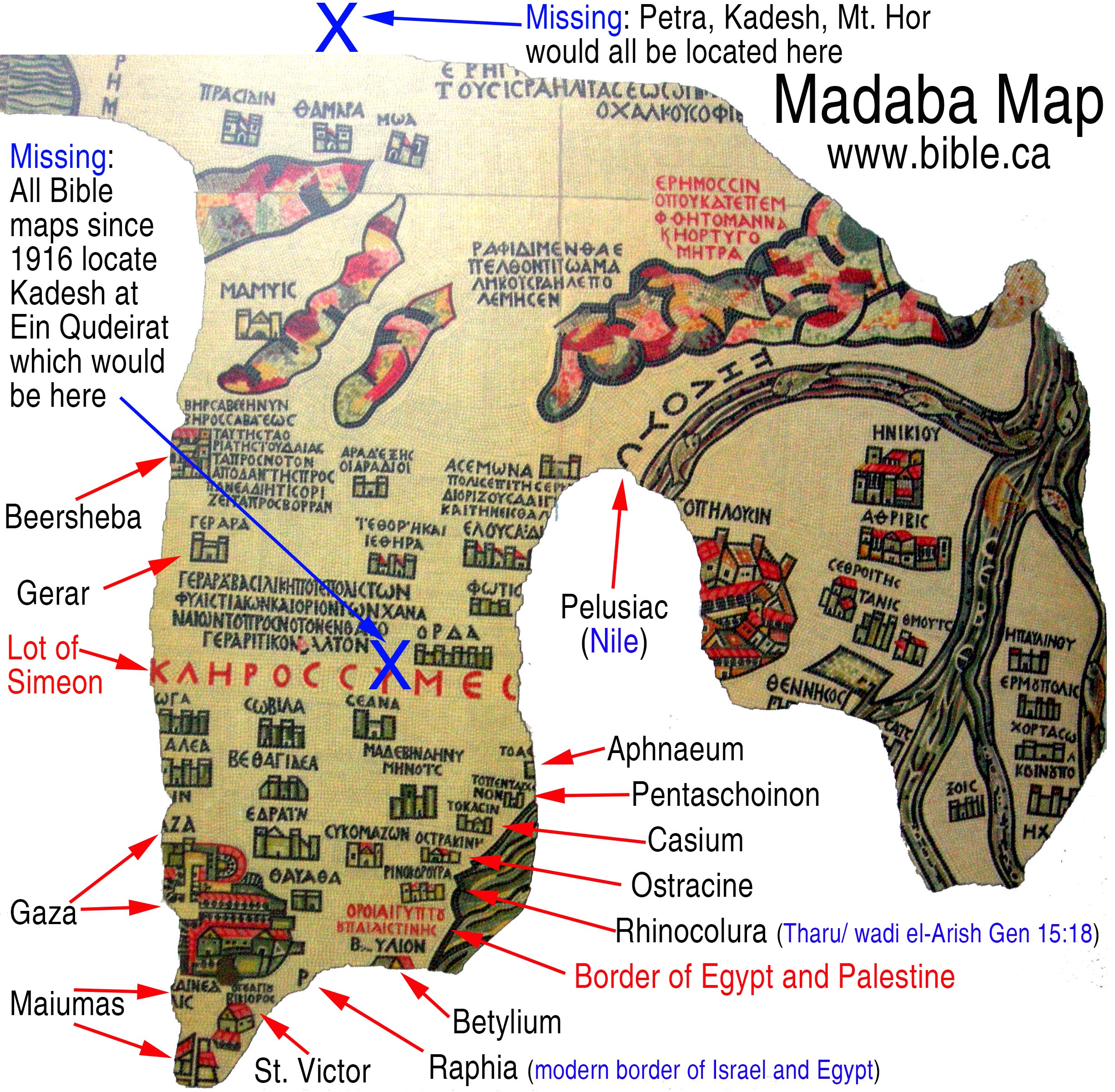
7. Nabatean trade routes collapsed in AD 50:
a. Strabo confirms that the Romans conquered the Arabian trade route towns on the southern Nile and the Judean Negev.
b. “between Egypt and Ethiopia… Petronius (AD 50) captured the Arabian towns of which we will give a list, the only ones we have found there: Pselcis, Primi [Primis], Boechis, Cambyses’ Market, Attenia and Stadissis, where there is a cataract of the Nile the noise of which affects people dwelling near it with deafness; he also sacked the town of Napata.” (Pliny the Elder, Natural History, 6.35.179,181-182, 77 AD)
c. Strabo and Josephus confirmed the collapse of the Nabatean kingdom in AD 50: Strabo, Geography 16.2.34; 16.4.21; Josephus Antiquities 13.257-258.
N. AD 124 Dionysius of Alexandria: Arabia was Arabia Felix
MASTER SUMMARY: AD 124 Dionysius of Alexandria. In AD 124 Dionysius composed the “Dionysius Periegetes” which means “Dionysius the Voyager” or more simply, the “Travels of Dionysius”. His geographic work reflects the world at the time of Paul before Trajan annexed the Sinai Peninsula and added it to the Transjordan Nabatean kingdom centered at Petra. Dionysius abuts Syria to Egypt between Mt. Casius (Lake Serbonis) and Mt. Libanus (Mt. Hermon). Dionysius positions Arabia entirely Transjordan, east of both Elat and Mt. Hermon then south to the Indian Ocean (Dionysius lines 897-903). Dionysius identified Arabia as being identical to Arabia Felix to the exclusion of the Sinai Peninsula (Dionysius lines 923-928). Dionysius followed Strabo (Strabo, Geography 16.4.2) in listing the Nabateans east of Mt. Hermon, as the first of three Arab nations in a west to east sequence from the Nile to the Persian Gulf: “So, then, first beyond the slope of Libanus [Mt. Hermon] dwell the rich people called the Nabataei [Nabatean kingdom at Petra]. Near them are the Chaulasii and the Agrei [Hagarites], beyond whom is the land of Chatramis, opposite the Persian land.” (Dionysius lines 954-956) Dionysius lists the same three Arabian tribes of Nabataei, Chaulasii, Agrei [Hagarites] east of Syria as Strabo, Geography 16.4.2. This confirms both Dionysius and Strabo viewed Arabia as equal to Arabia Felix and did not include the Sinai Peninsula. The Arabian spice trade routes collapsed around AD 50 and the Arab controlled cities south of Beersheba in the Judean Negev and Rhinocolura came under Syrian control in the vacuum of the First Jewish War in AD 66-72. Although composed after Trajan annexed the Sinai in AD 106, Dionysius does not in any way reflect the new political boundaries of Arabia Petra in his work but instead gives us a final snapshot of the Arabia Paul knew. This may be explained by his reliance on earlier geographic sources, his own life experiences before AD 106 and the fact that news traveled much slower in ancient times than in our current world of the Internet. Whatever the reason, Dionysius’ Arabia did not include the Sinai Peninsula.
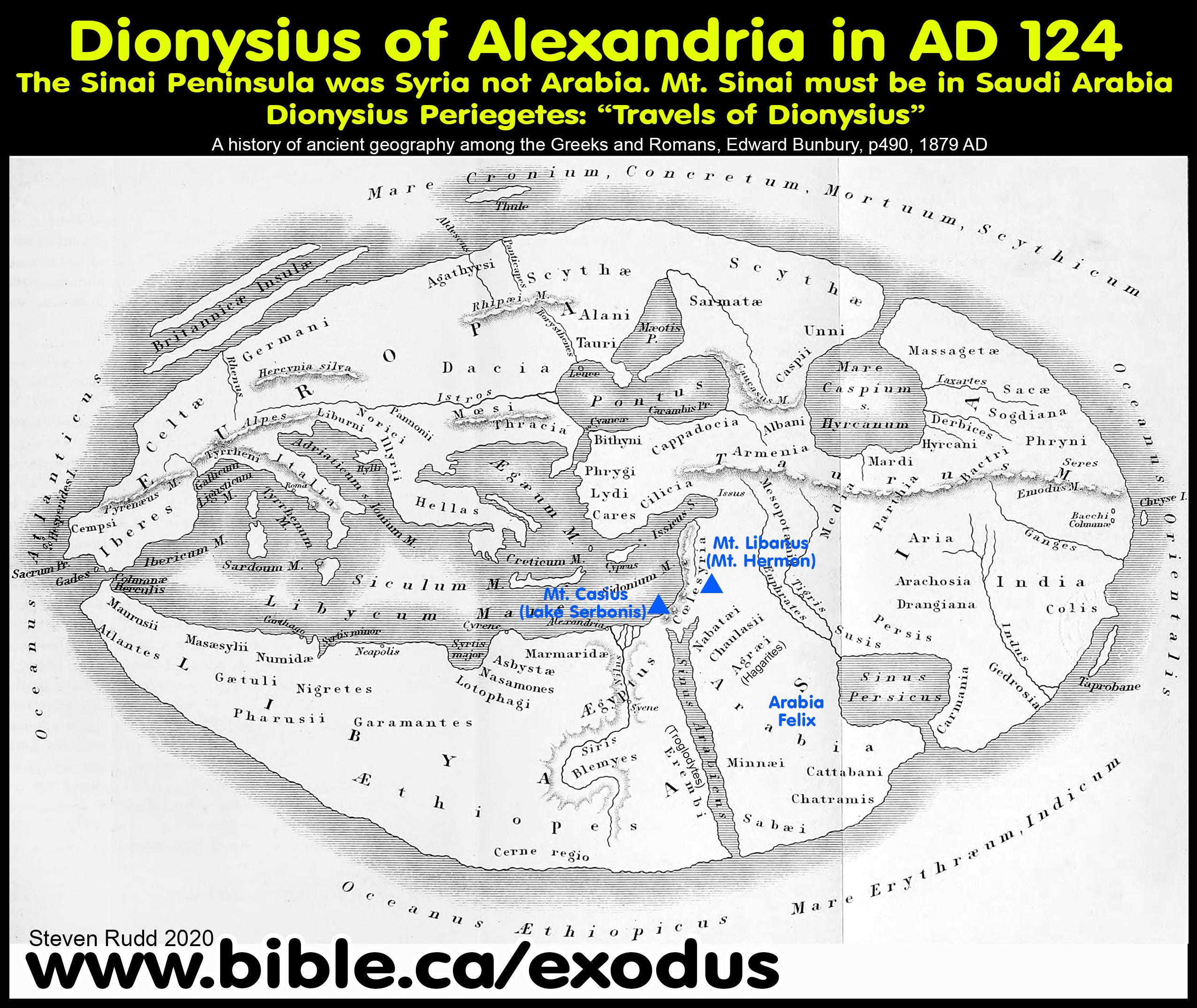
1. In AD 124 Dionysius composed the “Dionysius Periegetes” which means “Dionysius the Voyager” or more simply, the “Travels of Dionysius”.
2. “To what extent Dionysius relied on earlier geographical texts and to what extent, if any, he innovated upon previous descriptions of the OIKOVIIEVII [Dionysius Periegetes] is largely difficult to gauge. He appears to have taken his material from more than one source, so that the resulting picture is in some respects original to him. In the opening verses of the poem Dionysius describes the inhabited world as not quite circular, but wider along the ecliptic than from north to south, like a sling.” (A Commentary on Dionysius of Alexandria's Guide to the Inhabited World, Yumna Zahra Nadezhda Khan, p17, 2002 AD)
3. Translation of Dionysius Periegetes: “So let there be a shape of four sides, stretching towards the east in long plains. Now you know, as you heard me say so in the first place, (890) that a mountain cuts all of Asia in two as far as the Indians. That would form the more northerly of the sides, and the Nile would be the western side. The eastern side would be the Indian Ocean, and the southern would be formed by the waves of the Erythraean Sea. Consider how I shall now make my way to the east along the coast, (895) beginning from Syria, where I left off, and no man could accuse me of giving a false account. Well, then, Syria goes beyond the sea nearby to the south and east, with a land that has many cities, which they call 'Hollow', because it is in the middle (900) of mountain-peaks which render it low down, the peaks of Casius [Mt. Casius above Lake Serbonis] in the west and Libanus [Mt. Hermon] in the east. Many wealthy men inhabit this land, though they do not dwell together under one name, but separately, some inland, who are called Syrians, (905) and some near the sea, named Phoenicians. They are of the race of men who are Erythraeans, who first made an attempt on the sea in ships, and were the first to turn their minds to trade by sea and consider the far chorus of the heavenly stars. (910) These men inhabit lope and Gaza and Elais, and ancient Tyre and the lovely land of Berytus, and Byblus by the sea and flowery Sidon, situated by the waters of the charming Bostrenus., and fertile Tripolis, and Orthosis and Marathos (915) and Laodice, which lies on the shores of the sea, and the fields of Poseidon and the sacred vales of Daphne [where stands Antiocheia, named after Antiochus]. In the midst of these is the city of Apameia, to the east of which flows the moist Orontes, (920) immense, and dividing the land of Antiochus through the middle. The whole region is fertile and abounds in pasture, to feed the sheep and cause the fruit on the trees to grow. Beyond this land [Syria] you would see, as you made your way further south, the innermost path of the Arabian gulf, which winds (925) between Syria and lovely Arabia [Arabia Felix], turning a little to the east as far as Elana [Elat]. From there the land of the most fortunate Arabs [Arabia Felix] extends reaching far, and girded by twin seas, the Persian and the Arabian. Each has been allotted a wind, (930) the Arabian the west wind and the Persian the paths of the east wind. The southern coast facing the east is washed by the waves of the Erythraean Ocean. And I shall tell you of its position. For it is inhabited by tribes who are fortunate [Arabia Felix] and noble beyond all others. (935) This land has been allotted another exceptionally great wonder. It always smells sweetly from the perfume of burnt offerings, either of incense, or myrrh, or fragrant grass or even divinely-scented mature frankincense or cassia. For indeed it was in that place that Zeus and at his birth there grew fragrant shrubs of every kind. The sheep too then became laden with shaggy fleeces in the pasture, and the lakes flowed with spontaneous waters. Birds from uninhabited islands elsewhere (945) came bearing leaves of untouched cinnamon. Then the god stretched a fawn-skin over his shoulders and garlanded his fair hair with lovely ivy, and slightly drunk with wine he brandished his wreathed thyrsi, smiling, and showered the men with great wealth. (950) For this reason even today the fields are thick with frankincense, the mountains with gold, and the rivers elsewhere with sacrificial offerings. The inhabitants themselves are a very wealthy people, glorying in soft robes of gold. So, then, first beyond the slope of Libanus [Mt. Hermon] (955) dwell the rich people called the Nabataei [Nabatean kingdom at Petra]. Near them are the Chaulasii and the Agrei [Hagarites], [see Strabo, Geography 16.4.2 for same list of people] beyond whom is the land of Chatramis, opposite the Persian land. Inhabiting the coast of the Erythraean Sea are the Minnaei and Sabae and the neighbouring Cletabani. (960) So many immense tribes inhabit Arabia, but there are also many more, for it is extremely vast. Towards the opposite shore [west of Arabian Gulf in Egypt and Ethiopia], under the blast of the west wind appears the wretched land of the mountain-dwelling Erembi [Troglodytes], who live their lives in dug-out rocks, (965) naked and without possessions. On their bodies burning from the heat the parched skin grows black. Thus, like wild animals, they roam and suffer hardships, unlike the people of the soft-living Arabs. For the deity has not given to all men an equal share in wealth. (970) Beyond Libanus [Mt. Hermon is the border between Syria and Arabia] towards the rays of the sun there lies stretched the extensive land of the other Syria, reaching as far as sea-washed Sinope. In the middle of this deep land there dwell the Cappadocians, experts in horsemanship, (975) and the Assyrians near the sea, by the mouth of the Thermodon.” (Dionysius Periegetes, 888-975, 124 AD)
O. AD 150 Claudius Ptolemy
MASTER SUMMARY: AD 124 Dionysius of Alexandria. In AD 124 Dionysius composed the “Dionysius Periegetes” which means “Dionysius the Voyager” or more simply, the “Travels of Dionysius”. His geographic work reflects the world at the time of Paul before Trajan annexed the Sinai Peninsula and added it to the Transjordan Nabatean kingdom centered at Petra. Dionysius abuts Syria to Egypt between Mt. Casius (Lake Serbonis) and Mt. Libanus (Mt. Hermon). Dionysius positions Arabia entirely Transjordan, east of both Elat and Mt. Hermon then south to the Indian Ocean (Dionysius lines 897-903). Dionysius identified Arabia as being identical to Arabia Felix to the exclusion of the Sinai Peninsula (Dionysius lines 923-928). Dionysius followed Strabo (Strabo, Geography 16.4.2) in listing the Nabateans east of Mt. Hermon, as the first of three Arab nations in a west to east sequence from the Nile to the Persian Gulf: “So, then, first beyond the slope of Libanus [Mt. Hermon] dwell the rich people called the Nabataei [Nabatean kingdom at Petra]. Near them are the Chaulasii and the Agrei [Hagarites], beyond whom is the land of Chatramis, opposite the Persian land.” (Dionysius lines 954-956) Dionysius lists the same three Arabian tribes of Nabataei, Chaulasii, Agrei [Hagarites] east of Syria as Strabo, Geography 16.4.2. This confirms both Dionysius and Strabo viewed Arabia as equal to Arabia Felix and did not include the Sinai Peninsula. The Arabian spice trade routes collapsed around AD 50 and the Arab controlled cities south of Beersheba in the Judean Negev and Rhinocolura came under Syrian control in the vacuum of the First Jewish War in AD 66-72. Although composed after Trajan annexed the Sinai in AD 106, Dionysius does not in any way reflect the new political boundaries of Arabia Petra in his work but instead gives us a final snapshot of the Arabia Paul knew. This may be explained by his reliance on earlier geographic sources, his own life experiences before AD 106 and the fact that news traveled much slower in ancient times than in our current world of the Internet. Whatever the reason, Dionysius’ Arabia did not include the Sinai Peninsula.
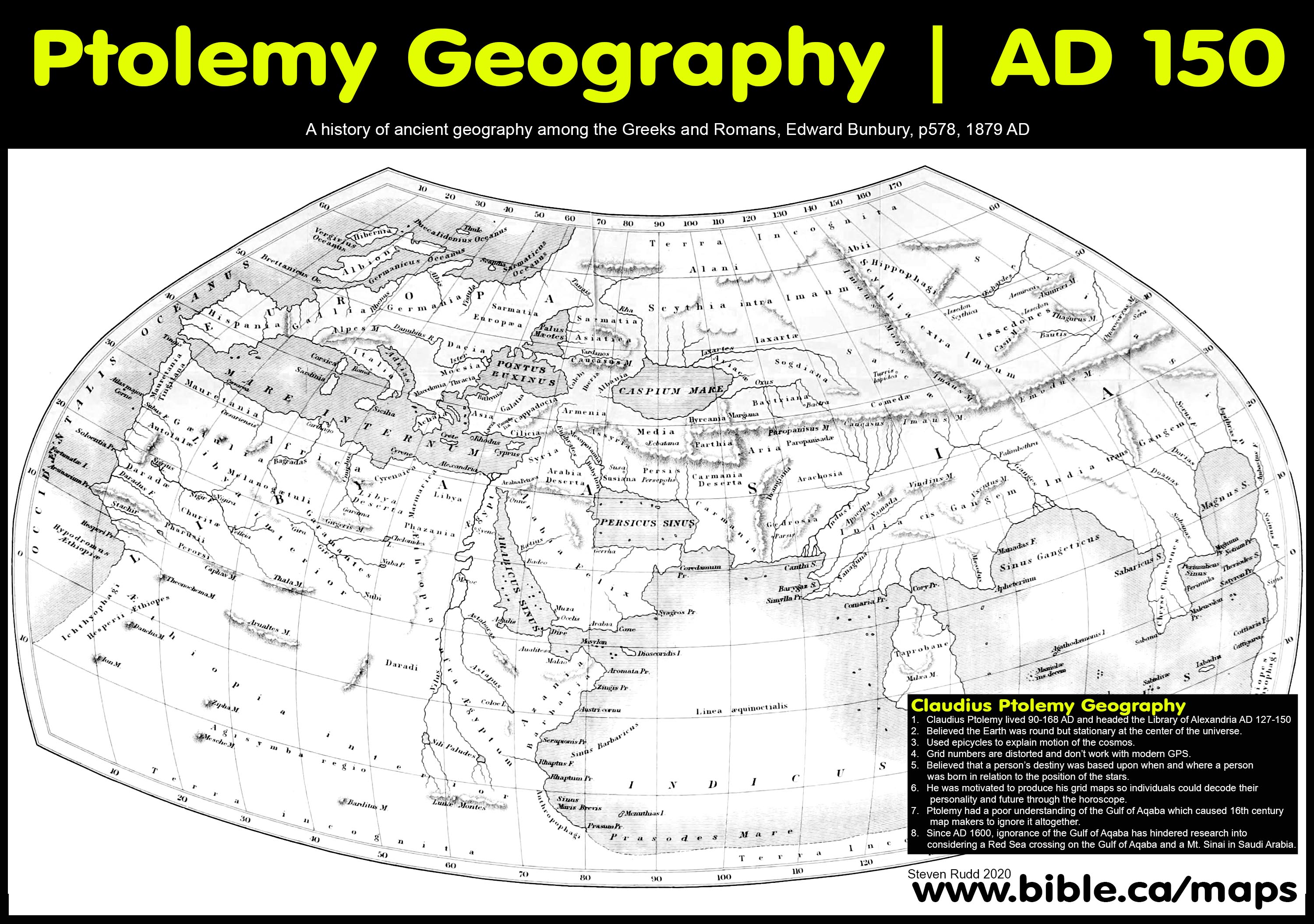
1. Claudius Ptolemy (Klaudios Ptolemaios) AD 90-168 was a Greek who lived in the Roman Capital of Egypt, (Alexandria), and headed the library at Alexandria from AD 127 to 150.
a. He wrote “Geography” that marked all known places onto a grid. Grid numbers are distorted and don’t work with modern GPS.
b. Ptolemy believed the Earth was round but stationary at the center of the universe. He used epicycles to explain motion of the cosmos.
c. Ptolemy believed that a person’s destiny was based upon when and where a person was born in relation to the position of the stars. He was motivated to produce his grid maps so individuals could decode their personality and future through the horoscope.
d. Ptolemy had a poor understanding of the Gulf of Aqaba which caused 16th century map makers to ignore it altogether. Since AD 1600, ignorance of the Gulf of Aqaba has hindered research into considering a Red Sea crossing on the Gulf of Aqaba and a Mt. Sinai in Saudi Arabia.
2.
Northern Sinai Peninsula is Egyptian: The Sinai Egyptian triangle
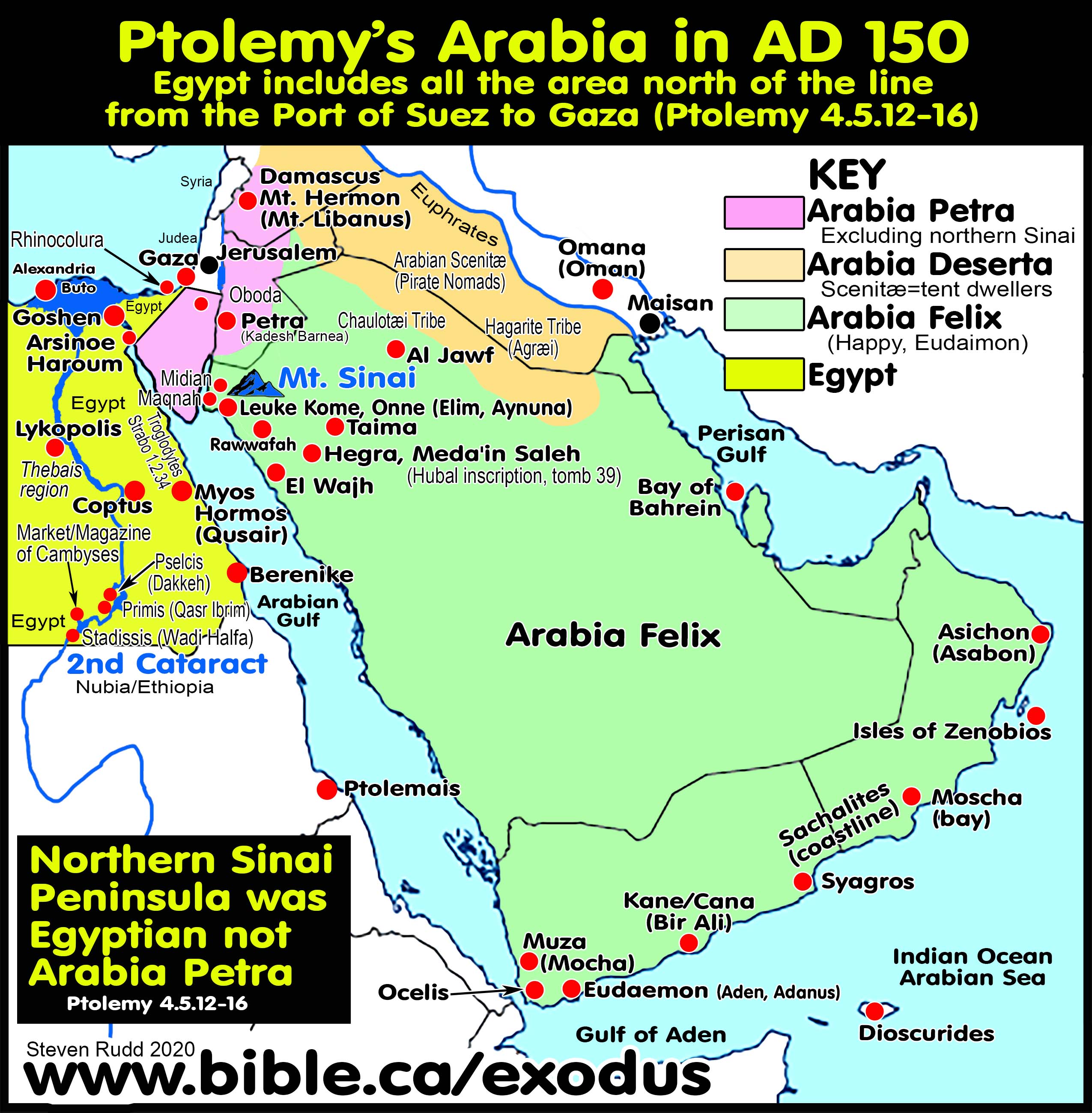
a. In 4.5.12-16 Ptolemy defines the eastern borders of Egypt. Ptolemy considers the area inside the triangle between Pelusium, Heroon/Arsinoe [Port of Suez] and Gaza [Anthedon] to all be part of Egyptian territory. Ptolemy considered Rhinocolura and Raphia to be part of Egypt in AD 150. Before AD 50 and at the time of Strabo, Rhinocolura was an Arab controlled port city for the Arabic trade route. Ptolemy defined Arabia Petra to include the central and southern portions of the Sinai Peninsula east of the Gulf of Suez over to Petra. Ptolemy defined the northern Sinai Peninsula as being part of Egypt not Arabia. We know historically that the Sinai Peninsula was added to Arabia Petra by Trajan in AD 106, but the northern Sinai was under full Egyptian control because after AD 50, the Romans developed a trade route to India and the Nabatean cities south of Beersheba in the Judean Negev collapsed. Ptolemy then traced the border of Egypt on the west side of the Gulf of Suez and the Arabian Gulf down to the border with Ethiopia.
b. Egyptian Territory defined: “The seven mouths of the Nile: the Herakleotikon or Kanobic mouth . 60°50' . 31°05'. the Bolbitine mouth . 61°15' . 31°05'. The Sebennytic mouth . 61°30' . 31°05'. The Pineptimi false mouth . 61°45' . 31°05'. Diolkos false mouth . 62°10' . 31°10'. The Pathmitic mouth . 62°30' . 31°10'. The Mendesios mouth . 62°45' . 31°10'. The Tanitic mouth . 63°00' . 31°15'. The Pelousiac mouth . 63°15' . 31°10'. Pelousion city . 63°15' . 31°10'. Gerron border . 63°30' . 31°10'. In Kassiotis: Kassion 63°45' . 31°15'. Outlet of the Sirbonis lake . 63°50' . 31°15'. Ostrakine 64°15' . 31°50'. Rhinokoroura [Rhinocolura/Arish] 64°40' . 31°50'. Anthedon [Gaza] 64°50' . 51°40'. It is bounded on the east by part of Judaea which runs from Anthedon city to the end point at 64°15' . 30°40' and thence by Arabia Petraia as far as the inmost point in the Arabian gulf at Heroon city, at 63°30' . 29°50' and by a part of the Arabian gulf, described as follows: After the above-mentioned inmost point of the gulf at 63°30' . 29°50' Arsinoe . 63°20' . 28°50'. Klysma castle 63°20' . 28°50'. Drepanon promontory 64°00' . 27°50'. Myos hormos 64°15' . 26°45'. Philoteras harbor 64°05' . 27°50'. Mt. Aias 64°20' . 26°10'.” (Claudius Ptolemy, Geography 4.5.10-14, translated by Brady Kiesling, 150 AD)
3. Arabia Petra: Old Nabatea
a. Judea, Philistia, Heroopolite gulf [Gulf of Suez], Elanite gulf [Gulf of Aqaba], Oboda, Petra. Oboda was a Nabatean city located south of Beersheba that functioned before AD 50 as a trade route town.
b. “Arabia Petraia [Arabia Petra] is bounded on the west by that part of Egypt to which we have referred; on the north by Palestina [Philistia] or Ioudaia [Judea] and the part of Syria along dividing line; on the south by the inmost point of the Arabian gulf, at 63°30' . 29°50' and by the Heroopolite gulf [Gulf of Suez] from the limit of Egypt up to the Pharan promontory, which is located at 65°00' . 28°30' and by the near side of the Elanite gulf [Gulf of Aqaba], until its return at 66°00' . 29°00' The position of Pharan kome is 65°00' . 28°40'. Elana kome [Elat], which is located in the inmost recess of the bay of this name [Gulf of Aqaba], has this position 65°50' . 29°15'. To the east its boundary is the line leading to the eastern limit of Syria, as we have indicated, running beside Arabia Felix, to the part of this line at 70°00' . 30°30' along Arabia Deserta for the remainder of the line. The so-called Melana mountains extend from the recess of the gulf at Pharan toward Judaia. West of these mountains toward Egypt extends Sarakene; below this is Mounychiatis; below which on the gulf are the Pharanitai, and along the mountains of Arabia Felix the Raithenoi. There are cities in the province, inland, and komai as follows: Eboda [Oboda] 65°15' . 30°30'. Petra 66°45' . 30°20'” (Claudius Ptolemy, Geography 5.17.1-5, translated by Brady Kiesling, 150 AD)
c. Elusa was a Nabatean controlled town for the trade route before AD 50 located south of Beersheba: “Of Idoumaia [Nabatean], which is all to the west of the Jordan river: Berzama 64°50' . 31°15'. Kaparorsa 65°30' . 31°15'. Gemmarouris 65°50' . 31°10'. Elousa (Elusa) 65°10' . 30°50'.” (Claudius Ptolemy, Geography 5.17.1-5, translated by Brady Kiesling, 150 AD)
4. Arabia
Deserta: For Ptolemy, Arabia Deserta is the desert between Syria and the
Euphrates but does not include the large central desert of the Arabian
Peninsula.
5. Arabia
Felix:
a. Ptolemy defined Arabia Felix as the entire Arabian Peninsula south of Syria, Petra and Midian (Geography 6.7.1-2; 6.7.27)
b. Ptolemy and Strabo placed Midian and Maknah in Arabia Felix, located near Al Bad, Saudi Arabia: “The cities and komai in Arabia Felix located in the interior are the following: Aramaua 67°30' . 29°10' Hostama 69°30' . 29°00' Thapaua 71°40' . 29°00' Makna or Maina [Maknah] 67°00' . 28°45' Ankale 68°15' . 28°45' Madiama [Midian] 68°00' . 28°15' (Claudius Ptolemy, Geography 6.7.27, translated by Brady Kiesling, 150 AD)
c. Onne is located near Midian at biblical Elim, known by Strabo as Leuke Kome, located at modern Ain Ounah (Aynuna). Sygros is located on the south-eastern corner of the Arabian Peninsula on the Arabian Sea. “Eudaimon Arabia [Arabia Felix] is bounded on the north by the designated border of Arabia Petraia [Arabia Petra] and of Arabia Deserta; on the northeast by a part of the Persian gulf; on the west by the Arabian gulf; on the south by the Red Sea; on the east by that part of the Persian gulf and the sea, which extends from the entrance to this gulf as far as the Syagros promontory. The [north-west] coast of this region is as follows: after the border of the Arabian gulf in the inmost part of the Elanite gulf [Gulf of Aqaba], Onne 66°20' [Leuke Kome]. 28°50'; Modiana or Modouna [Not same as Midian, but south of Onne on coast] 66°40' . 27°45'” (Claudius Ptolemy, Geography 6.7.1-2, translated by Brady Kiesling, 150 AD)
P. AD 325 Eusebius Onomasticon: Mt. Sinai in Saudi Arabia near Midian
MASTER SUMMARY: AD 325 Eusebius Onomasticon: Eusebius located Mt. Sinai and Mt. Horeb “beyond Arabia” in Midian, Saudi Arabia: “Horeb: The mountain of God in the land of Madiam [Midian]. It lies beside Mount Sinai beyond Arabia in the desert” (Eusebius Onomasticon, Choreb). He said that Kadesh Barnea was in Arabia, but Midian, Mt. Sinai, Mt. Horeb and Paran are “beyond Arabia. Four times Eusebius described places that he knew were in Arabia, as being “beyond Arabia” and this odd unit was possibly a hidden code to protest Helena’s recent choice of Mt. Sinai at St. Catherine’s monastery in the Sinai Peninsula. Eusebius likely disagreed with Helena but chose to remain silent. Oddly, there is no entry for Mt. Sinai but there is one for Mt. Horeb which he locates beside Mt. Sinai in Midian. Even so, for Eusebius, Arabia was always Transjordan and never in the Sinai Peninsula, in any part of Egypt, the Judean Negev or on the Mediterranean coast at Rhinocolura. Eusebius listed Transjordan towns in Moab, Ammon, and Aram as being part of “Arabia” including: Ashtaroth (Deut 1:4), Arabōth Mōab (Numbers 26:3), Amman, Argob (Deut 3:4), Arnon, Baal-meon (Num 32:38), Bostra, Gerasa, Hesbon, Endri, East of the Jordan River, Petra, Kadesh Barnea, Kanath, Medaba. The Madaba map of AD 542 was based directly upon the Onomasticon (dictionary of places) of Eusebius. Directly contradicting Constantine’s mother Helena, Eusebius did not locate Mt. Sinai in the Sinai Peninsula or near Petra but at Midian in northwest Saudi Arabia.
1. For Eusebius, Arabia was always Transjordan and never in the Sinai Peninsula, in any part of Egypt, the Judean Negev or on the coast at Rhinocolura. The Madaba map of AD 542 was based directly upon the Onomasticon (dictionary of places) of Eusebius.
a. He wrote his Onomasticon at the same time the Queen Helena, Constantine’s mother, chose Mt. Musa in the Sinai Peninsula at St. Catherine’s monastery. Eusebius likely disagreed with Helena on her Mt. Sinai at St. Catherine’s but chose to remain silent. Oddly, there is no entry for Mt. Sinai but there is one for Mt. Horeb which he locates in Midian beside Mt. Sinai.
b. Eusebius described Mt. Sinai, Mt. Horeb, Midian and Paran as being “beyond Arabia”. Only four times does Eusebius describe places that are known to be in Arabia, as being “beyond Arabia” and it appears they form a unit. He said that Kadesh Barnea was in Arabia, but Midian and Mt. Sinai are “beyond Arabia”.
c. This proves that Eusebius did not locate Mt. Sinai in the Sinai Peninsula or near Petra but at Midian in northwest Saudi Arabia.
2. Onomasticon entries:
a. Transjordan Arabia: Eusebius says that every major town in Moab, Ammon, and Aram is in “Arabia” including: Ashtaroth (Deut 1:4), Arabōth Mōab (Numbers 26:3), Amman, Argob (Deut 3:4), Arnon, Baal-meon (Num 32:38), Bostra, Gerasa, Hesbon, Endri, East of the Jordan River, Petra, Kadesh Barnea, Kanath, Medaba.
b. “Moab: (city) named from Moab the son of Lot. City of Arabia which is now (called) Areopolis. The territory is also called Moab, but its city is (rightly called) Habbath Moab (i.e., The Great of Moab).” (Eusebius Onomasticon, 325 AD)
c. “Jordan River: dividing Judaea and Arabia and the Aulim (of which we spoke above) next to the Dead Sea. It runs through Jericho and is lost in the Dead Sea. (After many twists it joins the Dead Sea near Jericho and disappears).” (Eusebius Onomasticon, 325 AD)
d. “Horeb: The mountain of God in the land of Madiam [Midian]. It lies beside Mount Sinai beyond Arabia in the desert [Where the mountain and the desert or the Saracens called Faran meet. It seems to me that the two names are for the same mountain which is now called Sinai and now Choreb.]” (Eusebius Onomasticon, 325 AD)
e. “Midian: City of one of the sons of Abraham and Cetura. Located beyond Arabia to the south in the desert of the Saracens, to the east of the Red Sea whence it was called Madianites, and now is called (the territory of) Madian. Scripture calls the daughter of Iobab [Jobab: Gen 10:29; 1 Chro 1:26] daughter of Madian. There is a second city named thus near Arnon and Areopolis, the ruins of which are pointed out.” (Eusebius Onomasticon, 325 AD)
f. “Paran: (Now) a city beyond Arabia adjoining the desert of the Saracens [who wander in the desert] through which the children of Israel went moving (camp) from Sinai. Located (we say) beyond Arabia on the south, three days journey to the east of Aila (in the desert Pharan) where Scripture affirms Ismael dwelled, whence the Ishmaelites [who are not the Saracens]. It is said (we read) also that (king) Chedorlaomer cut to pieces those in "Paran which is in the desert [Genesis 14:4-6]." (Eusebius Onomasticon, 325 AD)
Q. AD 300-400 Marcianus of Heraclea: The entire Arabian Peninsula is Arabia Felix:
MASTER SUMMARY: AD 300-400 Marcianus of Heraclea: Marcianus of Heraclea describes Arabia Felix as the entire Arabian Peninsula in a route from the Gulf of Aqaba south to the Arabian Sea, east to the Persian Gulf, the north up to Babylon. (Marcianus of Heraclea, Periplus of the Outer Sea 1.17a.11-18). This is consistent with all other geographers who preceded him.
1. “On the left or Asiatic side, the location of continent and seas is as follows. It is understood here again that it is best to state general names before local, and to give the relation of countries. So if you navigate the Arabian Gulf, and hold the continent on the left, you come first to Arabia Felix, which extends along the whole Arabian Gulf as far as the aforesaid Arabian Strait [Muza, Ocelis]. Beyond the narrows of the Arabian Gulf follows the Erythraean Sea [Red Sea] and if you navigate along It and hold the continent on the left you come to the well-known people of the Arabs, who inhabit all this continent. In this part of the sea is also the people of the Homerites, settled on the land of the Arabs and holding as far as the beginning of the Indian Ocean. Then beyond the Erythraean Sea follows the Indian Ocean. Now if you navigate the left hand side of this sea, holding next to the land of the Arabs as far as the mouth of the Persian Gulf, you come to the mountain of Syagrus [Syagros] and the great bay of Sachalites, which runs as far as the mouth of the Persian Gulf. If you enter the Persian Gulf and navigate it, holding the continent on the left as far as the mouths of the river Tigris (you come to the bay of the Fish-Eaters, which extends a long way, and the Laeanite bay [Bay of Bahrein?] of Arabia Felix and after that, the bay of Mesanites [port of Maisan near Basra], then, beyond the river Tigris) along the same Persian Gulf you come to the province of Susiana, not to omit Persis which lies next to Susiana, and after that the greater part of Carmania as far as the narrows of the Persian Gulf.” (Periplus of the Outer Sea, Marcianus of Heraclea, 1.17a.11–18, Translated by Wilfred H. Schoff, p17, 1927 AD)
R. AD 400 Jerome: Egypt borders Judea:
MASTER SUMMARY: AD 400 Jerome: Jerome said that Egypt borders Judea. “Judaea lies north of Egypt and south of Syria” (Jerome, Commentary on Daniel 11.11–12) He does not say that Egypt borders Arabia and Arabia borders Judea. At the time of Jerome the Sinai Peninsula was considered Egyptian just as it had been since the time of Moses. The Wadi el-Arish (River of Egypt) was the border between Egypt and the promised in Gen 15:18. Even today the Sinai Peninsula is Egyptian.
1. Jerome said: “Antiochus the Great, who now bears the title of king of the North, at the region where Egypt borders upon the province of Judaea. For owing to the nature of the region, this locality lies partly to the south and partly to the north. If we speak of Judaea, it lies to the north of Egypt and to the south of Syria. And so when he had joined battle near the town of Raphia at the gateway of Egypt, Antiochus lost his entire army and was almost captured as he fled through the desert.” (Jerome, Comm. on Da. 11.11–12, 400 AD)
S. AD 417 Egeria: Although Pithom is called the city of Arabia, it was understood to be inside Egypt:
MASTER SUMMARY: AD 417 Egeria: Egeria, a nun, travelled to Egypt, inside of which was Goshen. Egeria travelled to Egypt and called Pithom “Arabia” but then comments that it is part of the land of Egypt. (Egeria 7:1-5, AD 417). She was following the Septuagint which called Goshen “Arabia”. Although Pithom is called a city of Arabia, it was understood to be inside Egypt.
1. Dating Egeria: “It seems clear that Egeria’s Diary was written after 394; it is very probable that she could not have written it before 404; and there is reason to believe the work may not have been composed until 417. Suggestions of any later date are almost certainly to be rejected. The consensus of scholars is that the picture of church life which emerges from the narrative best describes the ecclesiastical and liturgical milieu of the early fifth century.” (Egeria: Diary of a Pilgrimage, George E. Gingras, p15, 1970 AD)
2. “I was, of course, already acquainted with the land of Gessen [Goshen] from the time when I first went to Egypt. It was, however, my purpose to see all the places which the children of Israel had touched on their journey, from their going forth from Ramesses until they reached the Red Sea at a place which is now called Clysma, because of the fortress which stands there. It was, therefore, our wish to go from Clysma to the land of Gessen [Goshen], specifically to the city [Pithom – Tel el-Retaba] which is called Arabia. This city is in the land of Gessen, and this territory takes its name from it, that is, the “land of Arabia” is the “land of Gessen.” Though this land is a part of Egypt, it is nevertheless far better than the rest of Egypt. (Egeria, 7:1-5, 417 AD)
Conclusion:
1. Pauls’ Arabia was Arabia Felix, inside of which was the Nabatean kingdom.
a. Arabia at the time of Paul in AD 36 is defined as being between entirely Transjordan south of Damascus, Petra, the Gulf of Aqaba, Petra and the Straits of Tiran.
b. Paul’s Arabia was the entire Arabian Peninsula excluding the Sinai Peninsula.
c. All ancient geographers before AD 70 understood Arabia proper as equal to Arabia Felix + Arabia Deserta and never described the Sinai Peninsula as Arabia.
d. For the purposes of locating Mt. Sinai, Paul’s Arabia it is essentially equivalent to Saudi Arabia of today.
e. No ancient literary source ever called the Sinai Peninsula Arabia at the time of Paul, before AD 70.
2. The apostle Paul likely visited Mt. Sinai in Arabia immediately after his conversion in order to fulfill one of the 24 antitypical shadows and echoes with Moses. If Moses was an antitype of Paul, both learned their respective Old and New Laws directly from God at Mt. Sinai.
3. Location of Mt. Sinai in Arabia: Gal 4:25
a. It is impossible for Mt. Sinai to be in the Sinai Peninsula if this area was never considered Arabia at the time of Paul.
b. Mt. Sinai must be in Saudi Arabia because Paul’s Arabia was Arabia Felix where Hagar and Ishmael lived.
|
|
Why not attend a good Bible believing local church in your own home town this Sunday. Click here to find the closest assembly of Christians to your house. |

By Steve Rudd: 2005 - 2020: Contact the author for comments, input or corrections.