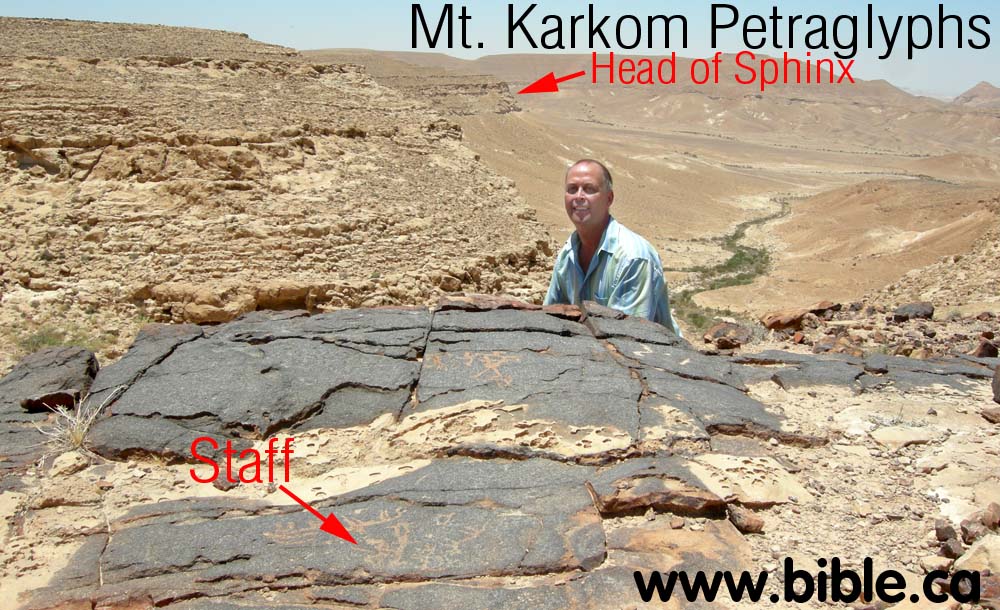
Mt. Karkom, Israel
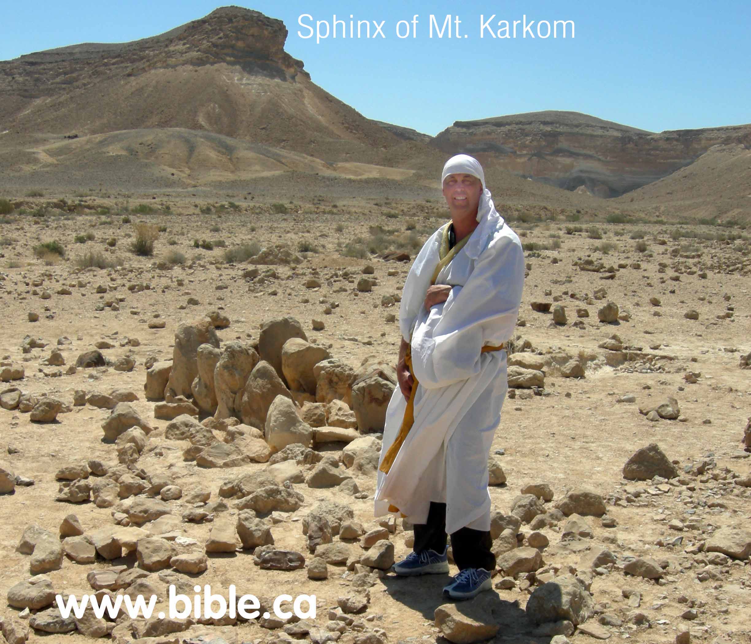
Steve Rudd examining petroglyphs
on Mt. Karkom
Introduction:
- Har Karkom is an important site, rich with archeological remnants of cultures that lived and worshipped at the mountain 2-3000 years ago. There are significant and important archeological remains in abundance at and around Mt. Karkom. It was clearly an important and well known location to the ancient world.
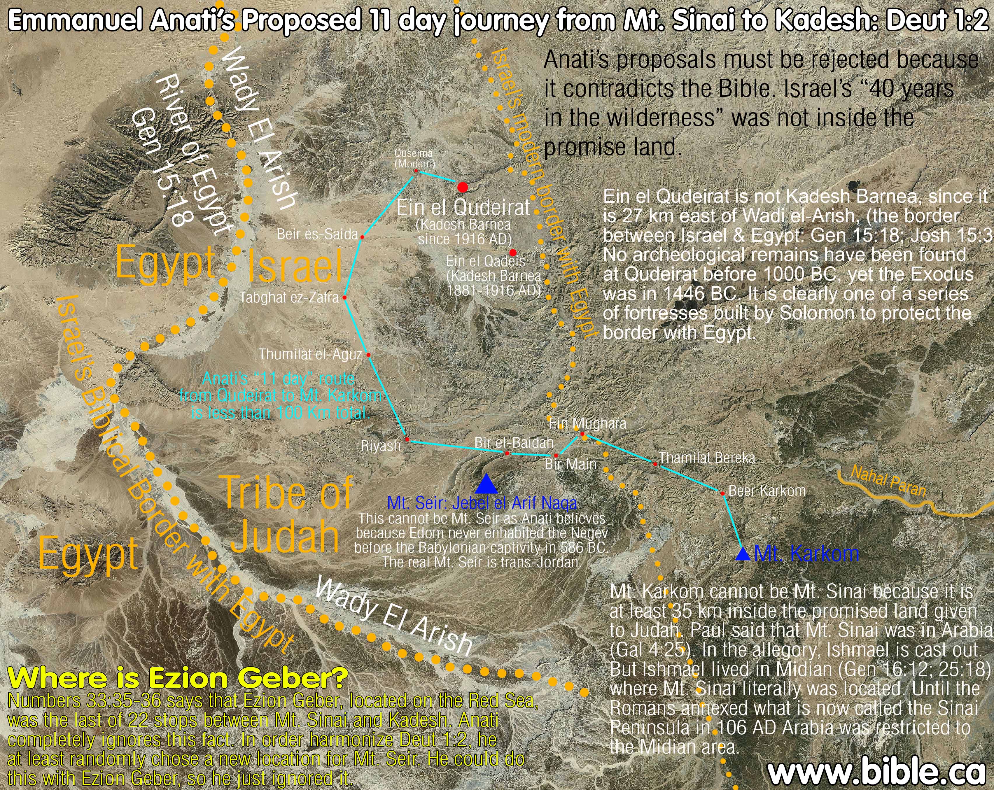
- Recently, Emmanuel Anati proposed Mt. Karkom as the location of mount Sinai. We feel the most compelling reason for rejecting Har Karkom as Biblical Mt. Sinai, is its location at least 35 km inside the Biblical boundaries of the promised land. Gen 15:18 and many other verses, says that the wadi Al-Arish (River of Egypt) is the southern boundary of Israel. For this reason alone we must reject Har Karkom as the location of Mt. Sinai. Emmanuel Anati's proposals must be rejected because it contradicts the Bible. Israel's "40 years in the wilderness" was not inside the promise land.
- Others believe Karkom is Kadesh Barnea, but again, neither Kadesh or Mt. Sinai were inside the promised land: "The archaeologist who has been overseeing an archaeological survey of the site [Mt. Karkom], Professor Emmanuel Anati, believes it to have been the mountain of the Ten Commandments (i.e. Mount Horeb). He is wrong in this assumption, but he has indeed found one of the most important places in the Exodus story. for this [Mt. Karkom] is the true site of Kadesh Barnea the holy gathering place where the multitude of Israel prepared to enter the Promised I and where they commemorated their covenant with Yahweh for the first time on top of the sacred mountain." (The Lost Testament, David Rohl, 2002, p 223-227)
- If Mt. Karkom was Mt. Sinai, then Moses need not make the trip to Mt. Nebo to view the promised land. He could have viewed Canaan from the Top of Mt. Sinai.
- Emmanuel Anati's proposed 11 day journey from Mt. Sinai to Kadesh (Deut 1:2) must also be rejected, since it does not go through Ezion-Geber. (see below) We find it incredible that Anati would use the Bible to map each station, yet ignore the fact the Bible explicitly says that Ezion-Geber was one of the stations in that route.
- Paul said that Mt. Sinai was in Arabia (Gal 4:25) no the land of Canaan or the Egyptian Sinai. In the allegory of Gal 4, Ishmael lived where Mt. Sinai literally was located. Yet we know from the Bible and archeology, that Ishmael lived in Midian: Gen 16:12; 25:18. Until the Romans annexed what is now called the Sinai Peninsula in 106 AD Arabia was restricted to the Midian area. The true Mt. Sinai is located in northern Saudi Arabia, probably at Mt. Lawz.
- There is significant evidence of an ancient Jewish presence at Mt. Karkom, but it is not Mt. Sinai.
- Israel Finkelstein, an Israeli archeologist, is a "Bible trashing modernist" who rejects the inspiration of the entire Bible. His unbelief lurks in the shadows of all his thinking. We, unlike Finkelstein, believe the Bible and the exodus story at true history. We reject the Mt. Karkom as Mt. Sinai, because it contradicts the Bible. Finkelstein also rejects the site as Mt. Sinai, because he believes the Bible story of the Exodus is a myth that never happened. Having said this, Finkelstein makes these factual statements about Mt. Karkom: "the concentration of these sites near Har Karkom is by no means unique. Similar clusters of sites can be found in other parts of the Negev. Indeed, the density of sites per square mile is much higher in other areas of the Negev Highlands than at Har Karkom. ... After eliminating the far-fetched interpretations and the misleading information [of Emmanuel Anati], we are left with some real facts: Here is a ridge in the Negev with more human occupation sites than the immediately neighboring ridges. In addition, Har Karkom differs from the main parts of the Negev Highlands by having a much larger number of rock drawings than at other sites" (Raider of the Lost Mountain - An Israeli Archaeologist Looks at the Most Recent Attempt to Locate Mt. Sinai, Israel Finkelstein BAR 14:04, Jul/Aug 1988)
- "The 75-square-mile area around the site boasts 40,000 petraglyphs—the largest concentration of rock art in the Negev—and 892 individual archaeological sites. The remains of a large Bronze Age campsite have been found in the mountain's foothills. Har Karkom still serves as a popular gathering place for nomads, just as it has over the millennia." (Guide to Sites, BAR 25:01, Jan/Feb 1999)
A. Archeological significance of Mt. Karkom:
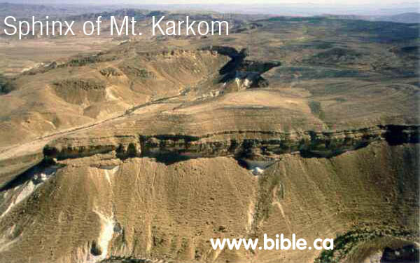
- Mt. Karkom is not a high mountain, but it is impressive with an outstanding natural "Sphinx" like feature at the head of the mountain. If Moses received the 10 commandments at Mt. Karkom, this feature would have been where it happened.
- There is a large natural open area at the base of the mountain for thousands of people to gather.
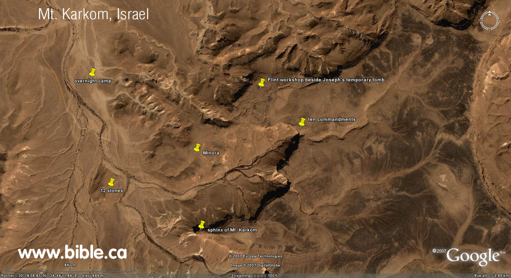
- The twelve stones: At the base of Mt. Karkom, directly in front of the "Sphinx".
- There are hundreds of petraglyph carvings on natural stone in the entire region. Two of the most notable are the graphic of the 10 commandments and the minora (candle stick).
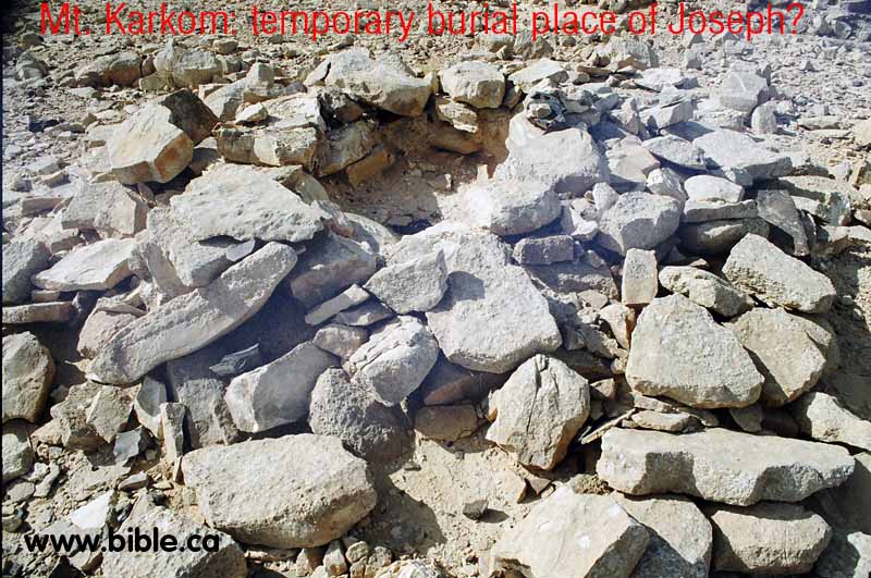
- On top of the mountain there is a pile of stones that is suggested by Emmanuel Anati to be the temporary burial place of Joseph.
- On several plateaus on and around the mountain there are large flint workshop areas for manufacturing flint knives, spears, scrapers etc. These flints were used for circumcision.
- There are several major areas of cult worship on top of the mountain. Idolatry was common during Israel's entire history.
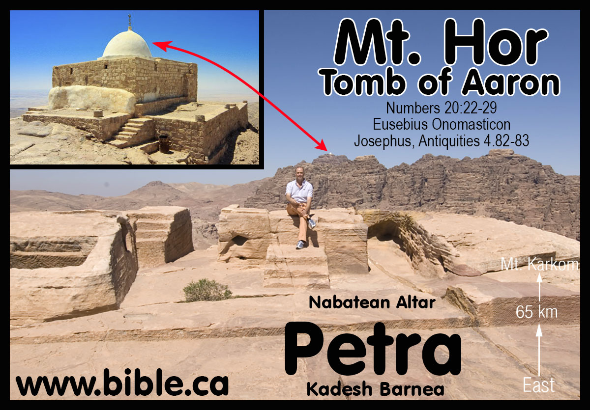
- On a hill top, one km east of Mt. Hor at Petra, there is
an ancient altar that is oriented due east and is also directly facing
both the tomb of Aaron and Mt. Karkom. Mt. Karkom is 65 km due east of
this altar. Archeology has uncovered ancient traces of Hebrew presence and
use. We are not sure what the connection is between Mt. Hor and Mt.
Karkom, but more research is needed. This altar may be connected directly
with the tomb of Aaron.
- Below is a photo of Mt. Karkom and the key spots we will
discuss in more detail below.
|
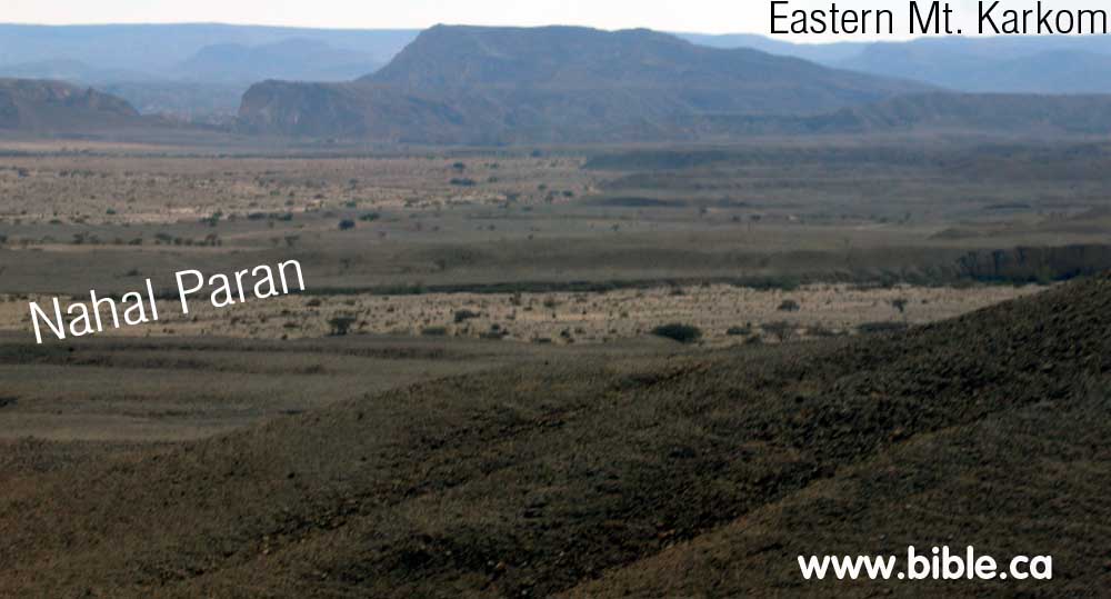
Here is a photo of Nahal paran where is intersects with Nahal Sira, looking towards the eastern slopes of Mt. Karkom. |
|
B. Har Karkom as Mt. Sinai:
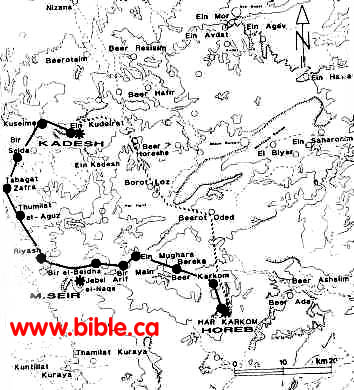
- In the early 1980's, Emmanuel Anati proposed Har Karkom was Mt. Sinai. He has done a huge amount of work in documenting the archeology of the area.
- Ein el Qudeirat has been the universal choice for Kadesh Barnea since 1916 AD, before this they looked transjordan east of the Arabah valley in what is now modern Jordan.
- Ein el Qudeirat is not Kadesh Barnea, since it is located 27 km east of Wadi el-Arish, (the border between Israel & Egypt: Gen 15:18; Josh 15:3) No archeological remains have been found at Qudeirat before 1000 BC, yet the Exodus was in 1446 BC. It is clearly one of a series of fortresses built by Solomon to protect the border with Egypt. Here is a detailed discussion about Ein el Qudeirat.
C. Deut 1:2: "11 days from Kadesh Barnea to Sinai" according to Emmanuel Anati
- Emmanuel Anati has drawn a map (Fig. 46) showing the route from Ein Qudeirat (proposed Kadesh Barnea) and Mt. Karkom according to Deut 1:2. Anaiti writes: . 'Eleven days from Horeb to Kadesh-barnea by the way of Mount Seir' (Deuteronomy 1:2). The map shows two trails from Har Karkom to Kadesh-barnea. The dark line passes by Jebel Arif el-Naqe, which can be identified as Mount Seir. The trail passes at the base of this mountain and has ten wells along its route. For a group of people on foot, the journey would take exactly eleven days. The other trail crosses the territory of Amalek, first climbing and then descending from the mountainous area of the central Negev. It is shorter, but more difficult. (HK Archive; WARA W05904).
- Anati has guessed at the 11 stops on a map and calculated
the distances. He seems overly concerned with finding natural water every
20km, when in fact the Israelites would carry a multi day supply of water
with them. Anati says: "From various Biblical passages it appears
that there are several ways to go from Horeb to Kadesh-Barnea. ... a human
group in the desert could hardly have covered more than 15-20 km daily.
And they would have needed water every day. ... allow me to propose the
identification of Mt. Seir with Jebel Arif en-Nake. From Har Karkom to Ein
Kudeirat (Kadesh Barnea) by way of Jebel Arif en-Nake, there is only one
way offering water sources at intervals of no more than 15-20 km. From Har
Karkom to Ein Kudeirat the distances are:
1. Har Karkom - Beer Karkom: 7km
2. Beer Karkom - Thamilat Bereka: 15km
3. Bereka - Ein Mughara: 13km
4. Ein Mughara - Bir Main: 7km
5. Bir Main - Bir el-Beidah: 9km
6. Bir el-Beidah - Riyash: 14km
7. Riyash - Thumilat el-Aguz: 13km
8. Thumilat el-Aguz - Tabghat ez-Zafra: 15km
9. Tabghat ez-Zafra - Beir es-Saida: 11km
10. Beir es-Saida - El-Kuseime: 12km
11. El-Kuseime - Ein Kudeirat: 8km
Total distance: 124 kilometers.
(Emmanuel Anati, BAR Queries / Comments, Vol. XII, May/Jun 1986, p. 22)
|
|
Emmanuel Anati's map "Fig 46". The 11 day journey route from Mt. Karkom to Ein Qudeirat fails to go through Ezion-Geber and for that reason must be rejected. |
|
|
We have overlaid Anati's 11 stops on a high resolution satellite image. Anati says the trip is 124km, but in fact it is less than 100km (60 miles). Of course most people wrongly believe that Mt. Sinai is Jebel Musa (traditional site) and their 11 day journey from the southern Sinai peninsula to Ein el Qudeirat is 250 km. Our proposed "11 day journey" from Jebel Al-Lawz to the Petra area is about 200km. We have calculated that the Israelites traveled between 23 - 30 km per day: Exodus route travel times, distances, days of the week. Anati's 9 km per day rate of travel is just too small to be realistic. |
D. Photo gallery of Mt. Karkom:
|
|
Here is the Sphinx of Mt. Karkom from the air. |
|
An exact replica of the Ark of the Covenant at the foot of Mt. Karkom, a candidate mountain for Mt. Sinai. |
|
|
|
Here is the Sphinx of Mt. Karkom standing in front of the ancient 12 stone monument. |
|
Panoramic view that is 170 degrees showing the Sphinx of Mt. Karkom. The safari truck is travelling east of south (about 70 degrees). There is an access road that leads from Highway 10 on the Israel/Egypt border. But access to the entire area is totally restricted being within a military zone. The general public simply cannot get to Mt. Karkom. |
|

E. Circumcision flint stone tools "factory" site.
|
|
Flint tools of an early phase of the BAC period, from plaza site HK 241: 1-Oval scraper on tabular flint. 2/3-Concave scrapers on primary flaking. 4-Oval scraper on flake. 5/6-Scrapers on primary flake. 7-Bifacial implement on tabular flint. 8-Dual-purpose implement on primary flake. (Drawings by Ida Mailland. HK Archive; WARA W05948). |
|
Here is a photo of actual flints from Mt. Karkom. The arrows point to places where the flint has been "worked" by chipping two pieces of together. |
|
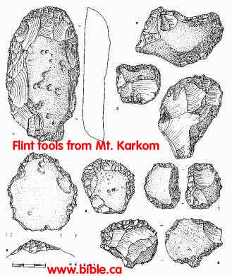
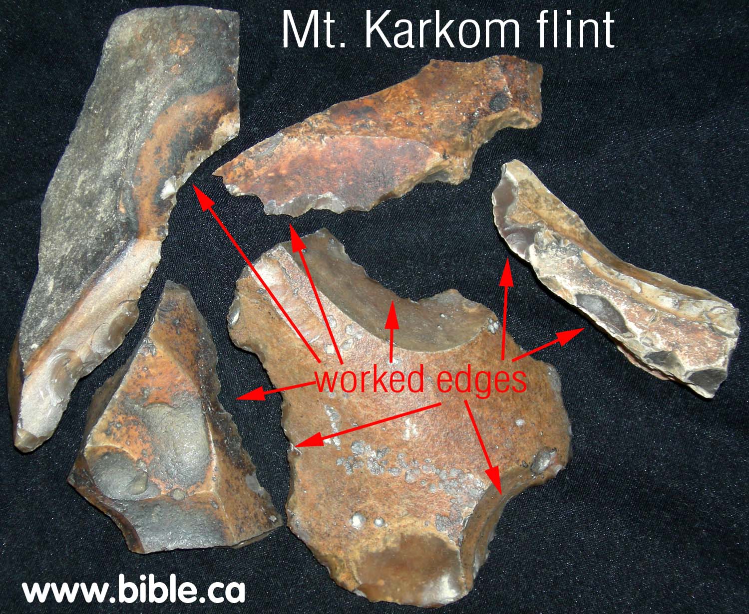
- There are several major "flint workshop" areas on top of the mountain and on plateaus. The flint found at Mt. Karkom and surrounding regions, is noted by geologists as being the hardest and finest in the world. Two pieces of flint are "worked" by hitting one against the other and chipping a flake off creating an ultra sharp edge. The edge is much sharper than what man can produce himself. The flint is still used in special surgery situations even today!
- Our theory is that one of reasons Mt. Karkom was important, was because this is where the Jews got their supply of surgical tools to perform circumcisions. So while we reject Mt. Karkom as Mt. Sinai, it is a very important place in ancient Jewish history.
- Below is a panorama view of two of the flint work shop areas. These areas are at least 50 feet in diameter and are littered with discarded flint fragments from manufacturing flint tools. You can see one area that takes up the entire right half of the photo and another one of similar size several hundred meters away in the left of the photo.
![]()
F. Joseph's temporary burial place?
- Emmanuel Anati believes he has found the temporary burial
spot of Joseph. You can see the pile of rocks in the panorama photo above
directly in front of the two camera men, is Joseph's temporary tomb and in
the close up in the photo below. We know that the Israelites carried
Joseph's body with them from Egypt, to Mt. Sinai and on to the promised
land 40 years later. If this really was Joseph's temporary tomb, we feel
that the Israelites would certainly have remembered it and never used the
plateau for a flint workshop. There are many large plateaus on top of Mt.
Karkom in other locations where they would have set up their workshop that
is littered with broken pieces and discards. Further, it is difficult to
say what the pile of rocks were used for. It looks like a fire pit,
although there is no evidence we saw of the rocks being burnt. Here is a
close up of "Joseph's tomb":
G. The Ten commandment Petraglyph:
On top of Mount Karkom, there is an amazing ancient petraglyph of the two tables of the covenant (the ten commandments). They are on this rock, along with many other ancient drawings etched in the black stone.
|
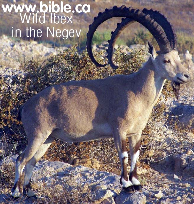
The Mt. Karkom area is full of petraglyph of common everyday life and
animals. You can see an Ibex with the four legs and long horns that extend
over the back on the rock. The wild Ibex in the photo below was taken near
Mt. Karkom. |
|
|
|
This petraglyph is probably 3000 years old. What is amazing is the way the ten commandments are graphically arranged: ..1....2.. No one knows how to interpret this unusual arrangement. |
|
In the picture above you can see where someone has scratched and damaged the petraglyph. This horrible vandalism, however reveals the contrast between a freshly carved rock and the ancient carving of the ten commandments. This carving is probably 3000 years old. |
|

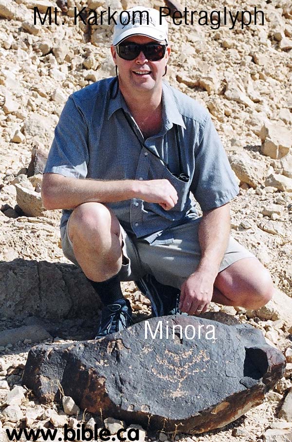
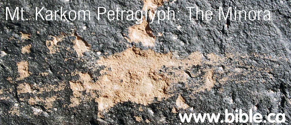
H. The Minora (candlestick) Petraglyph:
The Minora is near where this Panoramic photo was taken. This Panoramic view that is 200 degrees showing the path from camp up the mountain to the summit. Once you get on top, it is about one mile around to the Sphinx. The Sphinx is due south. The straight path with the team walking to the top from the base camp is oriented north of due east. (about 80 degrees on the compass)
|
|
|
|
|
On the ascent, near where the above photo was taken, is this amazing petraglyph of a minora. The minora or candle stick, was used in Hebrew worship in the tabernacle and Solomon's temple. |
|
The Minora close up. |
|
|
|
There appears someone vandalized the minora by scratching the base. Here is a close up of the damage from this photo taken in Nov 2005. |
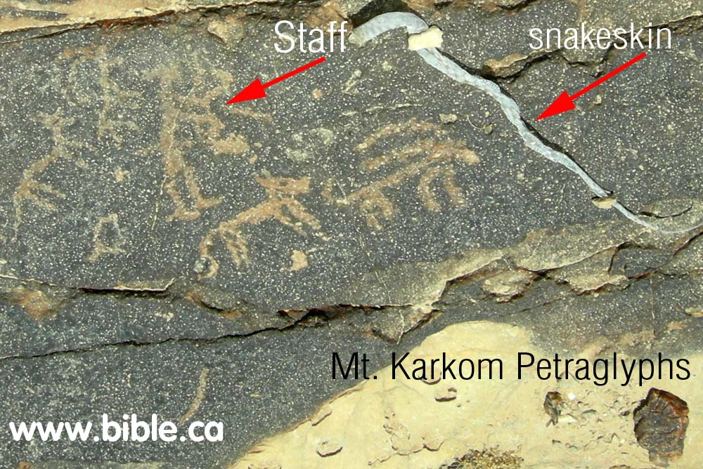
H. The "Staff" Petraglyph:
The snake and staff Petraglyphs
|
Looking up the wadi valley directly towards the "12 stones". The "man holding the staff" petraglyph is seen in the foreground. |
|
|
|
A man holding a staff. Real snake skin found beside rock. |
Conclusion:
- Mt. Karkom was an important location in the history of ancient Israel. While it is clearly not Mt. Sinai, it has the fingerprint of Hebrew occupation everywhere you turn: The Hebrew icons like the "minora" and the "tables of the covenant", the twelve stones, the flint workshops, the location on the southern end of Judah's territory and the border with Egypt, the multitude of cult worship sites (idol and pagan) on the mountain.
- The cult worship sites should not surprise us since for most of Israel's history from the exodus to the time of the Babylonian captivity in 586 BC, the Jews mixed the law of Moses with the local pagan practices of the land. The cult worship sites, therefore, are likely Hebrew, not gentile.
- Exactly how Mt. Karkom was used and why will be a mystery yet to be discovered.
By Steve Rudd: Contact the author for comments, input or corrections.