“Geography” by Claudius Ptolemy (Klaudios Ptolemaios) AD 90-168
Introduction:
1. Claudius Ptolemy (Klaudios Ptolemaios) AD 90-168 was a Greek who lived in the Roman Capital of Egypt, (Alexandria), and headed the library at Alexandria from AD 127 to 150. He wrote “Geography” that marked all known places onto a grid.
2. Claudius Ptolemy: 90-168 AD
a. Headed the Library of Alexandria AD 127-150
b. Believed the Earth was round but stationary at the center of the universe.
c. Used epicycles to explain motion of the cosmos.
d. Grid numbers are distorted and don’t work with modern GPS.
e. Believed that a person’s destiny was based upon when and where a person was born in relation to the position of the stars.
f. He was motivated to produce his grid maps so individuals could decode their personality and future through the horoscope.
g. Ptolemy had a poor understanding of the Gulf of Aqaba which caused 16th century map makers to ignore it altogether.
h. Since AD 1600, ignorance of the Gulf of Aqaba has hindered research into considering a Red Sea crossing on the Gulf of Aqaba and a Mt. Sinai in Saudi Arabia.
3. AD 150 Claudius Ptolemy: Ptolemy is most famous for his “earth centered” (geocentric system) where the earth is at the center of the universe and all the planets and stars revolve around the earth in a series of epicycles to explain their erratic travel path in the sky. Ptolemy was motivated by his views on astrology and the horoscope to map the movement of the cosmos above to precise locations on earth at the point of a person’s birth. Whereas the modern horoscope decodes your personality solely on the position of the planets at the date of your birth [i.e. June 15], Ptolemy used both birthdate and birthplace in relation to the position of the stars to determine decode individuals. His work on Geography was purposed not to map the world, but to provide “GPS” co-ordinates on a grid so that people could easily look up their place of birth and be provided a set of “east/west” grid numbers to determine their destiny. The grid numbers for Petra are “66°45' . 30°20'” but these in no way correspond to our modern global grid system in Google Earth etc. The grid numbers do allow the creation of a map that shows the relative locations of places where Ptolemy thought they were. There are many distortions and errors, but it is quite useful overall. Ptolemy did not understand the Gulf of Aqaba very well and 16th century map makers perpetuated the distortions in Ptolemy’s work. Since AD 1600, ignorance of the Gulf of Aqaba has hindered research into considering a Red Sea crossing on the Gulf of Aqaba and a Mt. Sinai in Saudi Arabia. While Ptolemy defined Arabia Felix as abutting Petra to the north, and included Midian to the north-west, and Arabia Deserta to the north-east, these new boundaries came into effect after Trajan in AD 106. At the time of Paul. Midian was Arabia Petra, below which was Arabia Deserta, below which was Arabia Felix. For Ptolemy, Arabia Deserta is the desert between Syria and the Euphrates but does not include the large central desert of the Arabian Peninsula which Strabo included in his definition. Strabo restricted Arabia Felix to the southern end of the Arabian Peninsula above which was Arabia Deserta.
4. In 4.5.12-16 Ptolemy defines the eastern borders of Egypt.
a. Ptolemy defines the northwestern portion of the Sinai Peninsula as Egyptian territory, the rest is Arabia Petra.
b. Ptolemy considers the area inside the triangle between Pelusium, Heroon/Arsinoe [Port of Suez] and Gaza to all be part of Egyptian territory. Ptolemy considered Rhinocolura and Raphia to be part of Egypt in AD 150. Before AD 50 and at the time of Strabo, Rhinocolura was an Arab controlled port city for the Arabic trade route. The central and southern Sinai Peninsula as defined by the area on the east side of the Gulf of Suez over the Petra is all part of Arabia Petra. We know historically that the Sinai Peninsula was added to Arabia Petra by Trajan in AD 106, but the northern was under full Egyptian control because after AD 50, the Romans developed a trade route to India and the Nabatean cities south of Beersheba became of no importance. Ptolemy then traces the border of Egypt on the west side of the Gulf of Suez and the Arabian Gulf down to the border with Ethiopia.
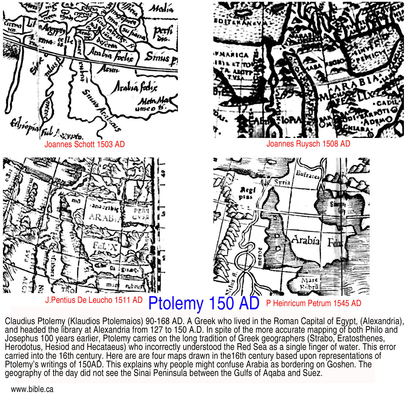
A. Poor understanding of the Gulf of Aqaba:
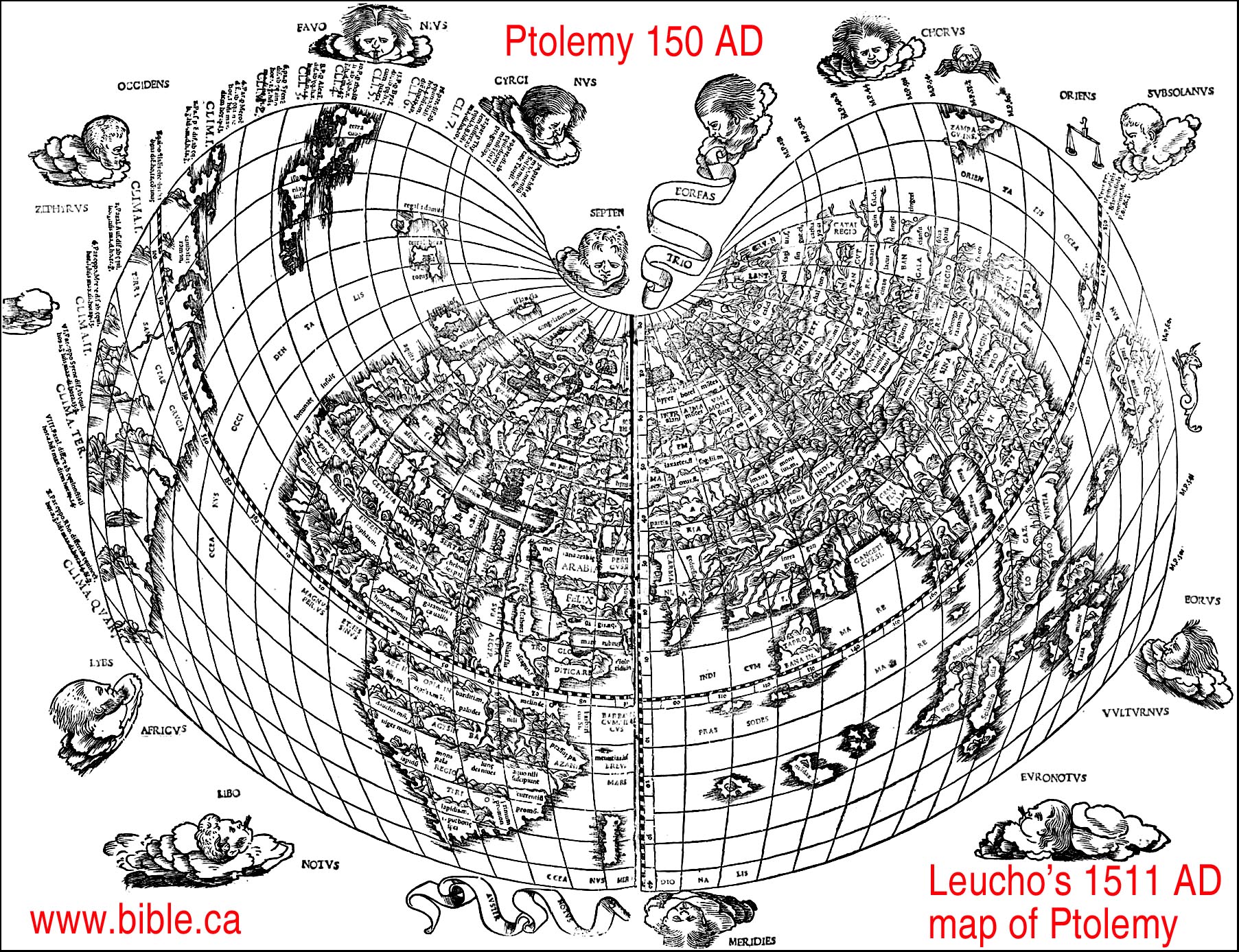
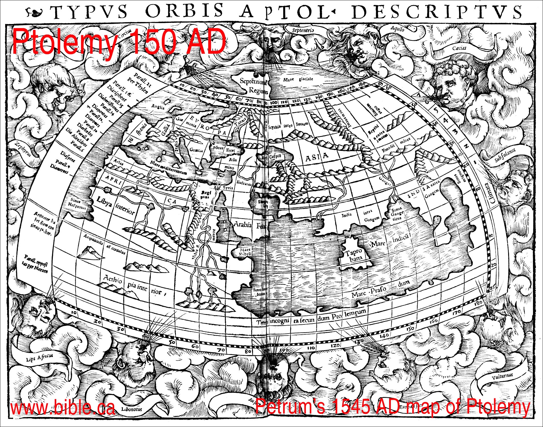
a. Despite the more accurate mapping of both Philo and Josephus 100 years earlier, Ptolemy carries on the long tradition of Greek geographers (Eratosthenes, Herodotus, Hesiod and Hecataeus) who incorrectly understood the Red Sea as almost a single finger of water.
b. As we can see, this error carried into the 16th century. Here are are four maps drawn in the 16th century based upon representations of Ptolemy's writings of 150AD.
c. This explains why people might confuse Arabia as bordering on Goshen. The geography of the day did not see the Sinai Peninsula between the Gulfs of Aqaba and Suez.
B. Four 16th century “Ptolemy” maps that ignore the Gulf of Aqaba:
- Joannes Schott 1503 AD, read
Ptolemy and drew this map from his writings:
- Joannes Ruysch 1508 AD, read
Ptolemy and drew this map from his writings:
- J.Pentius De Leucho 1511 AD, read
Ptolemy and drew this map from his writings:
- P Heinricum Petrum 1545 AD, read
Ptolemy and drew this map from his writings:
- Close up of the four maps:
C. Ptolemy citations:
1. Arabia Petra, Judea, Philistia, Heroopolite gulf [Gulf of Suez], Elanite gulf [Gulf of Aqaba], Oboda, Petra:
a. Oboda was a Nabatean city located south of Beersheba that functioned before AD 50 as a trade route town.
b. “Arabia Petraia [Arabia Petra] is bounded on the west by that part of Egypt to which we have referred; on the north by Palestina [Philistia] or Ioudaia [Judea] and the part of Syria along dividing line; on the south by the inmost point of the Arabian gulf, at 63°30' . 29°50' and by the Heroopolite gulf [Gulf of Suez] from the limit of Egypt up to the Pharan promontory, which is located at 65°00' . 28°30' and by the near side of the Elanite gulf [Gulf of Aqaba], until its return at 66°00' . 29°00' The position of Pharan kome is 65°00' . 28°40'. Elana kome [Elat], which is located in the inmost recess of the bay of this name [Gulf of Aqaba], has this position 65°50' . 29°15'. To the east its boundary is the line leading to the eastern limit of Syria, as we have indicated, running beside Arabia Felix, to the part of this line at 70°00' . 30°30' along Arabia Deserta for the remainder of the line. The so-called Melana mountains extend from the recess of the gulf at Pharan toward Judaia. West of these mountains toward Egypt extends Sarakene; below this is Mounychiatis; below which on the gulf are the Pharanitai, and along the mountains of Arabia Felix the Raithenoi. There are cities in the province, inland, and komai as follows: Eboda [Oboda] 65°15' . 30°30'. Petra 66°45' . 30°20'” (Claudius Ptolemy, Geography 5.17.1-5, translated by Brady Kiesling, 150 AD)
c. In 4.5.12-16 Ptolemy defines the eastern borders of Egypt. Ptolemy defines the northwestern portion of the Sinai Peninsula as Egyptian territory, the rest is Arabia Petra. Ptolemy considers the area inside the triangle between Pelusium, Heroon/Arsinoe [Port of Suez] and Gaza to all be part of Egyptian territory. Ptolemy considered Rhinocolura and Raphia to be part of Egypt in AD 150. Before AD 50 and at the time of Strabo, Rhinocolura was an Arab controlled port city for the Arabic trade route. The central and southern Sinai Peninsula as defined by the area on the east side of the Gulf of Suez over the Petra is all part of Arabia Petra. We know historically that the Sinai Peninsula was added to Arabia Petra by Trajan in AD 106, but the northern was under full Egyptian control because after AD 50, the Romans developed a trade route to India and the Nabatean cities south of Beersheba became of no importance. Ptolemy then traces the border of Egypt on the west side of the Gulf of Suez and the Arabian Gulf down to the border with Ethiopia.
c. “In Kassiotis: Kassion 63°45' . 31°15'. Outlet of the Sirbonis lake 63°50' . 31°15'. Ostrakine 64°15' . 31°50'. Rhinokoroura [Rhinocolura] 64°40' . 31°50'. Anthedon [Gaza] 64°50' . 51°40'. It [Egypt] is bounded on the east by part of Judaea which runs from Anthedon city [Gaza] to the end point at 64°15' . 30°40' and thence by Arabia Petraia as far as the inmost point in the Arabian gulf at Heroon city, at 63°30' . 29°50' and by a part of the Arabian gulf, described as follows: After the above-mentioned inmost point of the gulf at 63°30' . 29°50'. Arsinoe 63°20' . 28°50'. Klysma castle 63°20' . 28°50'. Drepanon promontory 64°00' . 27°50'. Myos hormos 64°15' . 26°45'. Philoteras harbor 64°05' . 27°50'. Mt. Aias 64°20' . 26°10'. Leukos harbor 64°30' . 26°00'. Mt. Akabe 64°30' . 25°45'. Nechesia 64°30' . 25°30'. Mt. Samaragdos 64°50' . 25°00'. Lepte akra 64°40' . 23°40'. Berenike 64°05' . 23°50'. Mt. Pentadaktylon 64°45' . 23°30'. Bazion promontory 65°00' . 23°00'. The boundary on the south extends to the indicated end point of Interior Libya adjacent to which line is Aithiopia [Ethiopia] below Egypt.” (Claudius Ptolemy, Geography 4.5.12-16, translated by Brady Kiesling, 150 AD)
3. Arabia Felix, Gulf of Aqaba, Onne (Elim, Leuke Kome, Aynuna), Sygros:
a. Ptolemy defined Arabia Felix as the entire Arabian Peninsula from Midian south then north to the Euphrates. While Ptolemy defined Arabia Felix as abutting Petra to the north, and included Midian to the north-west, and Arabia Deserta to the north-east, these new boundaries came into effect after Trajan in AD 106. At the time of Paul. Midian was Arabia Petra, below which was Arabia Deserta, below which was Arabia Felix.
b. For Ptolemy, Arabia Deserta is the desert between Syria and the Euphrates but does not include the large central desert of the Arabian Peninsula which Strabo included in his definition. Strabo restricted Arabia Felix to the southern end of the Arabian Peninsula above which was Arabia Deserta.
c. Onne is located in Midian at biblical Elim, known by Strabo as Leuke Kome, located at modern Ain Ounah (Aynuna).
d. Sygros is located on the south-eastern corner of the Arabian Peninsula on the Arabian Sea.
e. “Eudaimon Arabia [Arabia Felix] is bounded on the north by the designated border of Arabia Petraia [Arabia Petra] and of Arabia Deserta; on the northeast by a part of the Persian gulf; on the west by the Arabian gulf; on the south by the Red Sea; on the east by that part of the Persian gulf and the sea, which extends from the entrance to this gulf as far as the Syagros promontory. The [north-west] coast of this region is as follows: after the border of the Arabian gulf in the inmost part of the Elanite gulf [Gulf of Aqaba], Onne 66°20' . 28°50'; Modiana or Modouna [Not same as Midian], but south of Onne on coast] 66°40' . 27°45'” (Claudius Ptolemy, Geography 6.7.1-2, translated by Brady Kiesling, 150 AD)
4. Ptolemy has Syria bounded by Judea on the west, Arabia Deserta on the east and Arabia Petra on the south.
a. “[Syrian is] Bounded on the south by Judaia [Judea] according to the line drawn here, to the east, then returns south at the locality 67°10' . 32°20' and terminates at 68°00' . 31°15' and by part of Arabia Petraia along the aforementioned limit, up to the limit point at Arabia Deserta the position of which is 70°30' . 32°00'. On the east the border is bounded by the line which extends along Arabia Deserta to the Euphrates river crossing near Thapsakos, where the limit at the Euphrates is 73°20' . 35°10' thence by the Euphrates river along Mesopotamia, to the limit of this river at Kappadokia at 71°20' . 38°00'” (Claudius Ptolemy, Geography 5.15.6-7, translated by Brady Kiesling, 150 AD)
5. Midian and Maknah: located near Al Bad, Saudi Arabia:
a. “The cities and komai in Arabia Felix located in the interior are the following: Aramaua 67°30' . 29°10' Hostama 69°30' . 29°00' Thapaua 71°40' . 29°00' Makna or Maina [Maknah] 67°00' . 28°45' Ankale 68°15' . 28°45' Madiama [Midian] 68°00' . 28°15' (Claudius Ptolemy, Geography 6.7.27, translated by Brady Kiesling, 150 AD)
6. Elusa was a Nabatean controlled town for the trade route before AD 50 located south of Beersheba:
a. “Of Idoumaia [Nabatean- Arabia Petra], which is all to the west of the Jordan river: Berzama 64°50' . 31°15'. Kaparorsa 65°30' . 31°15'. Gemmarouris 65°50' . 31°10'. Elousa (Elusa) 65°10' . 30°50'.” (Claudius Ptolemy, Geography 5.16.10, translated by Brady Kiesling, 150 AD)
Conclusion:
1. Ptolemy had a poor understanding of the Sinai Peninsula or the Gulf of Aqaba despite the fact he was head of the Library of Alexandria.
2. Renaissance map makers could copy Ptolemy’s ignorance of the Gulf of Aqaba which prevented anybody from considering the Gulf of Aqaba as a Red Sea crossing and Mt. Sinai in Saudi Arabia.
3. This error would persist in maps until c. 1800.
4. Today, scripture indicates that the Gulf of Aqaba is the Red Sea crossing point at the Straits of Tiran.
By Steve Rudd: Contact the author for comments, input or corrections.