The Search for Ai: 11 Bible keys
Second Conquest city of Joshua in 1406 BC
|
Et-Tell |
Khirbet el-Maqatir |
|
Ai of Abraham: 2090 BC |
Abraham’s Altar: 2090 BC Ai of Joshua: 1446 BC Ephraim of Jesus: AD 33 First Jewish War: AD 69 Byzantine church: AD 375 |
Archaeological confirmation of the Bible account of Joshua’s conquest
“What you read in the Book you find in the ground!”
Introduction:
1. Ai is one of the most important sites in the Old Testament.
a. Originally Ai (et-Tell) was a major city occupied from the time of the tower of Babel (2850 BC) until it was abandoned in 2320 BC.
b. During this time, the city was built, burned, destroyed, and rebuilt 4 times.
2. The Hebrew name “Ai” means “the ruins” and the archaeological name “e-Tell” means “the hill”. The original name of the city is unknown.
a. Ai’s reputation and history of being “ruined” 4 times by fire, made it is easy to understand why the city was nicknamed “the great ruin” at the time of Abraham.
b. Ai had been abandoned for 230 years before Abraham built his altar west of Ai in 2090 BC.
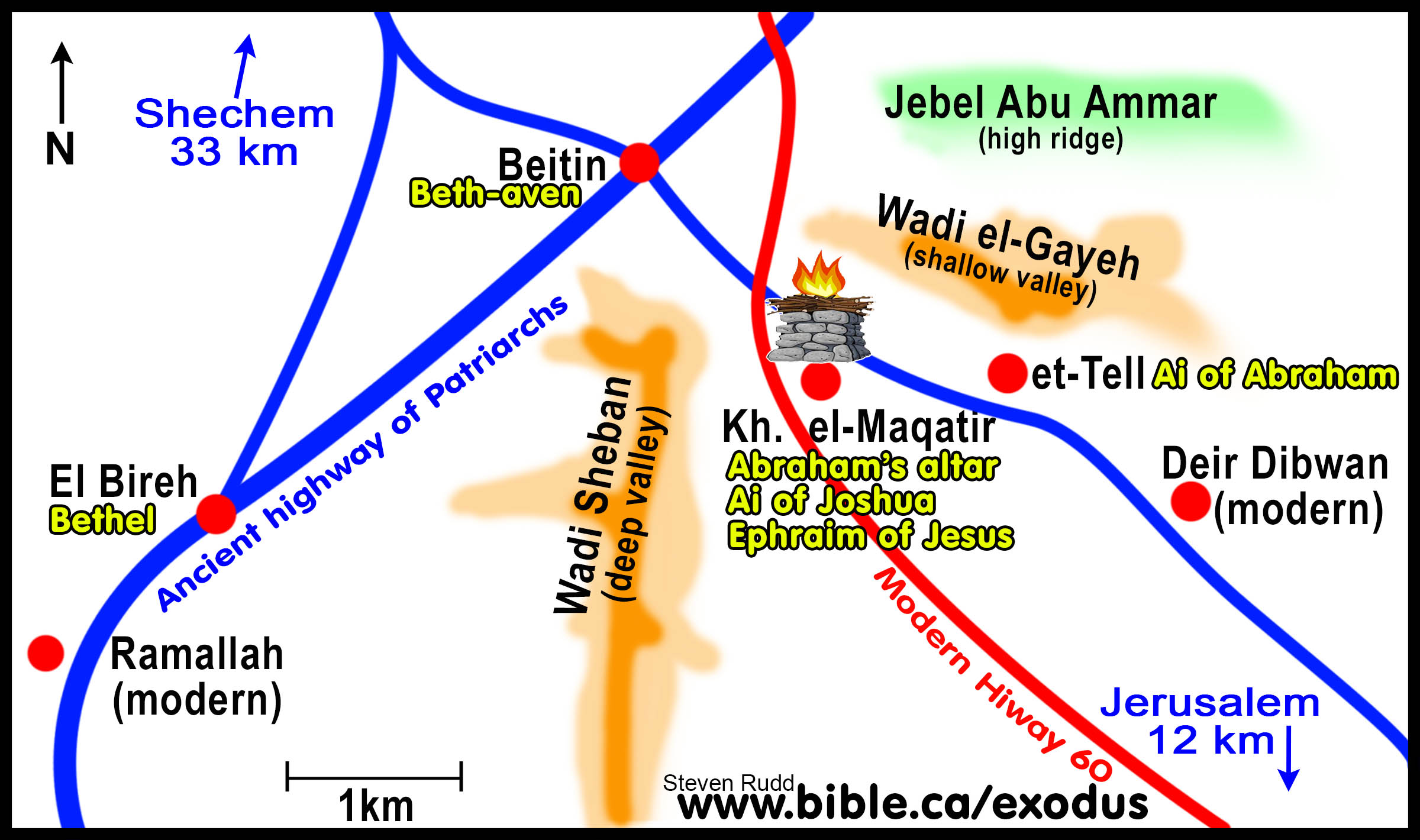
3. Until recently, the location of Ai puzzled Bible students and geographers, but this all changed when the solution was to understand that there were two different geographic locations of cities, both named Ai in the Bible.
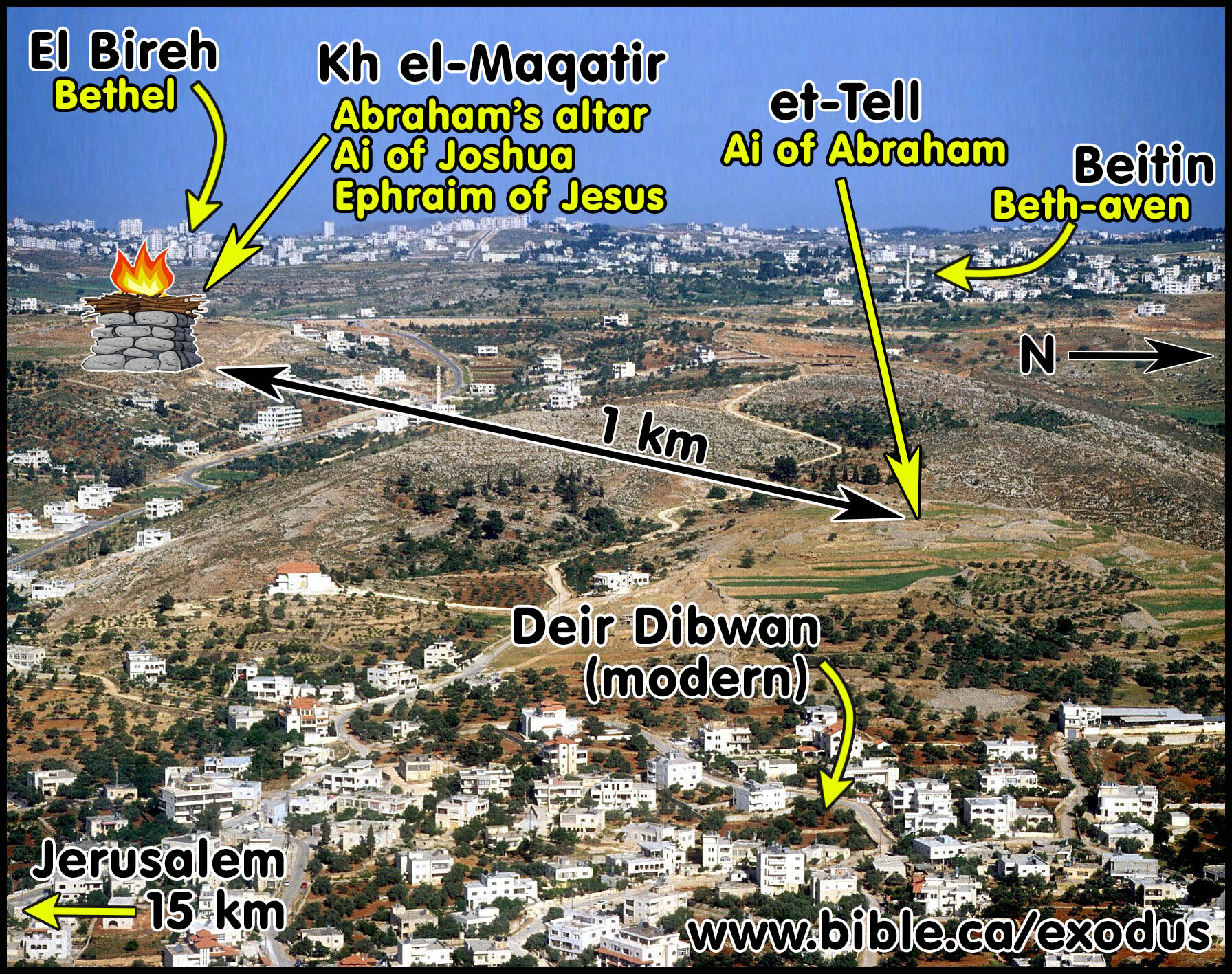
a. We do not know the original name of the city nicknamed “the ruin” (Ai) at the time of Abraham. There is universal agreement that archaeological site named “et-Tell” was the Ai of Abraham. When Abraham arrived, the city was a well-known location. Abraham built his altar on another archaeological site named “Khirbet el-Maqatir, which was “between Bethel and Ai (et-Tell).
b. Sometime before the time of Joshua, a new city named “Ai” was built at Kh. el-Maqatir, which was 1 km west of Abraham’s Ai (et-Tell). This new city was not a “ruin”, but as was common in the ancient world, the traditional name of ancient Ai was adopted and transferred to the new living city nearby. Kh. el-Maqatir, called “Ai” in scripture, was the second conquest city of Joshua.
c. The solution to the puzzle of the geographic location of Ai is acknowledging there are two places called “Ai”. One was the ancient abandoned “ruined” (Ai) city Abraham saw in 2190 BC located at et-Tell and the second was the fortified walled city called Ai that Joshua conquered and burned in 1406 BC located 1 km west at Khirbet el-Maqatir.
A. Biblical Ai was located at two different sites which were occupied in six different time periods:
1. Et-Tell: A powerful ancient walled city that was abandoned at the time of Abraham and nicknamed “Ai” (ruins):
a. FIRST: Original city: 2850 - 2320 BC: Et-Tell was likely founded directly after the dispersion of the Tower of Babel in 2850 BC during the “Late Uruk 3 Expansion” which was contemporaneous and concurrent with Early Bronze Age I. The unnamed city at Et Tell was an important and major commerce center for over 500 years.
b. SECOND: “Ai” Ruined city: 2090 BC: The fact that the city was abandoned, and the ruins were a geographic marker in relation to Abraham’s altar in 2090 BC confirm the location was famous and widely known in ancient times.
2. Khirbet el-Maqatir: The Ai of Joshua, the Ephraim of Jesus, fortress of second Jewish war, Byzantine church.
a. THIRD: Et-Tell was the Ai of Abraham in 2090 BC: Et-Tell is one km east of Khirbet el-Maqatir. The altar of Abraham built at Khirbet el-Maqatir was between Bethel and Ai, the famous and well known abandoned city nicknamed “ruined”. The arch
b. FOURTH: Joshua in 1406 BC: After Jericho, Ai was the second conquest city located at Khirbet el-Maqatir where pottery, objects, 5-meter city wall and city gate all date to the Late Bronze Age IB. The city was burned by Joshua and the king as buried in the city gate.
c. FIFTH: Jesus in AD 33: After raising Lazarus in the spring of AD 33, and the plot to kill him that ensued, Jesus withdrew to Ephraim with his disciples just before the final Passover (John 11:54). Ephraim is identified with Khirbet el-Maqatir as a perfect fit.
d. SIXTH: Christians in in the Byzantine era built a single apse church on the summit 200 meters west of the first century city of Ephraim.
B. 2850 – 2320 BC: The original unnamed city at et-Tell was occupied for over 500 years:
Note: Excavations have found five occupational phases: Dates follow “Christian Archaeological Dating” because the oldest archaeology on earth must be younger than the global Noahic flood in 3298 BC (see: “Nimrod and the Archaeology of the Tower of Babel, Steven Rudd, 2019 AD, ISBN-10: 1092122311).
1. 2850-2650 BC: The founding phase began shortly after the great dispersion at the Tower of Babel in 2850 BC (Late Uruk 3 Expansion = Early Bronze Age I) and featured a small 11,000 sq/m, unfortified residential city, which was destroyed by fire sometime during the Early Bronze Age II = Late Uruk, (2800-2700 BC) coinciding with both with the founding of Kish in Mesopotamia and Egyptian dynasty 2.
2. 2650-2550 BC: In the Early Bronze Age III, with the rise of the 3rd Egyptian dynasty and the construction of the first pyramid on earth by Djoser’s (Stepped Pyramid-2660 BC), it was a time for thinking big and building big. The second phase of et-Tell was a huge 111,000 sq/m city. Nearby Jericho, also founded shortly after the Tower of Babel, was much smaller at 40,500 sq/m. This occupational phase had been built with clear signs of preplanning which included a 3-meter-wide, fortified city wall with four gates, a large temple and palace on the summit, a public market and residential area. An intense fire destroyed the entire city and excavators found a layer of ash on the palace floor.
3. 2550-2450 BC: Continuing in the Early Bronze Age III, the city was rebuilt and reorganized during the time of Khufu (2nd king, Dynasty 4: 2580–2560) who built the famous “great Pyramid of at Giza”. The new palace was half the size of its predecessor. For the third time, the city was destroyed by fire which was possibly caused by an earthquake: “collapsed roof beams were covered over by stones from walls and clay which covered the beams; they smoldered with enough intensity to dissolve the stones into calcined masses, cementing pieces of pottery into lumps and baking sun-dried bricks into a pottery-like consistency.” (ABD, Ai) Excavators documented a short 20-40 year period of abandonment as evidenced by water erosion channels cut through some of the houses.
4. AI of ABRAHAM: 2400-2320 BC: During the end of the Early Bronze Age III, once again the city was rebuilt. Excavators noted a clear Egyptian influence as evidenced by some architectural similarities and objects. “Alabaster and stone vessels imported from Egypt were among the temple furnishings” (ABD, Ai). At the beginning of the Early Bronze Age, the final destruction of Ai was around 2320 BC, which coincided with the rise of Sargon I of Akkad (2320-2265 BC) and the end of Egyptian dynasty 5 with the death of Pharaoh Unas (2352-2321 BC). “A few pieces of Khirbet Kerak ware (Pottery) have been found in the last phase of Early Bronze Age III occupation. The city seems to have been destroyed by military action after the Khirbet Kerak culture appeared in the north and presumably penetrated to Jericho. The excavator believes that the city fell during the disintegration of the Pyramid Age dynasties in Egypt, before the end of Early Bronze Age III in Palestine.” (Encyclopedia of Archaeological Excavations in the Holy Land, Ai). Khirbet Kerak Ware was a distinctive and high-quality Early Bronze I pottery style found at ancient Tel Khirbet Kerak (Philoteria) located on the southern shore of the sea of Galilee. The reason for the final destruction of Al is unknown and it was abandoned and remained unoccupied from 2300-1200 BC. It was this ruined city that Abraham saw when he built his altar 1 km west on a hill located on the summit of Kh. el-Maqatir in 2090 BC.
5. 1200 BC: After 1100 years of abandonment a tiny 11,000 sq/m, Iron Age IA city was occupied, probably by Hebrews.
C. 2090 BC: The Ai of Abraham was the ruins of the abandoned city located at et-Tell:
1. ABRAHAM in 2090 BC: Khirbet El-Maqatir is the location of the altar of Abraham during the Early Bronze Age IV (EB IV = 2320-1886 BC).
2. Jerusalem, the Jordan valley and the Salt sea were all clearly visible when standing on the summit of Khirbet el-Maqatir, which confirms this was the place God told Abraham to look around and see the land his seed would be given.
D. 1446 BC: The Ai of Joshua was the Late Bronze Age IIA city located at Khirbet el-Maqatir:
1. JOSHUA in 1446 BC: Khirbet el-Maqatir is the location the second conquest city of Joshua named “Ai”, during the Late Bronze Age IIA (LB IIA = 1406–1295 BC). The Ai of Abraham is Et-Tell. The Ai of Joshua is Khirbet El-Maqatir located 1 km west of Et-Tell.
2. The city of Ai of Joshua borrowed the name from Et Tell, which was a ruin at the time of Abraham as a kind of echo-morphic name. Although Ai at the time of Abraham was 1 km east of the later Ai of Joshua, Abraham was standing on the spot where the later Ai of Joshua would be founded. It is common in antiquity for a city to be destroyed and a new one is built nearby that borrows the same name. New Testament Jericho was built about 2 km from the ruins of Old Testament Jericho destroyed by Joshua in 1406 BC.
|
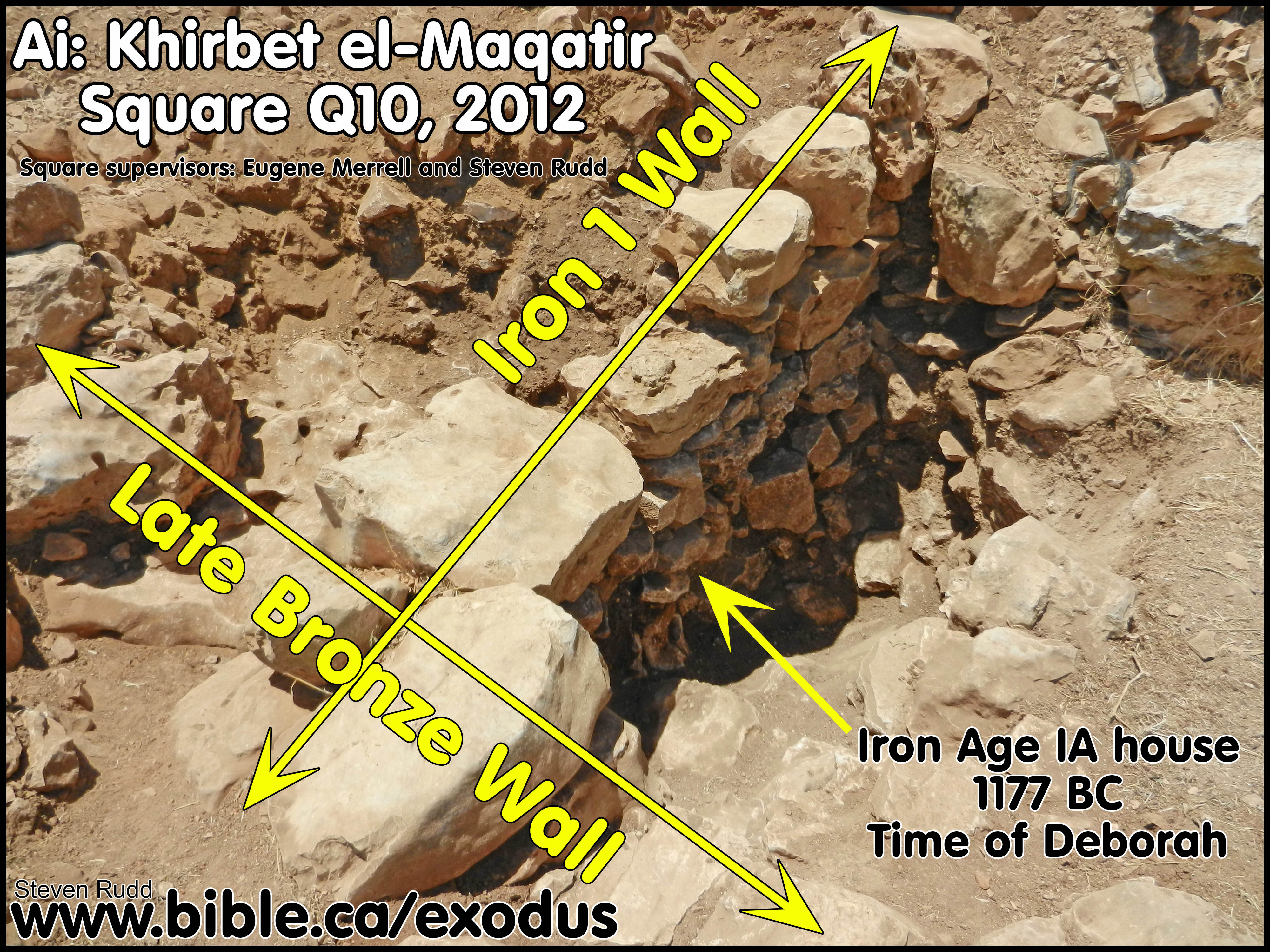
3. The author was staff archaeologist from 2011-2016 AD at Kh. El-Maqatir. Excavations documented the Late Bronze Age, 5-meter-wide wall that surrounded the city Joshua conquered in 1406 BC and the city gate where the king of Ai was buried. The photo is the author’s square Q10 from the 2012 excavation season which documented the Iron I age (1177-1010 BC) walls were built up against the Late Bronze age city wall to create houses for families. |
|
E. AD 33: The Ephraim of Jesus in John 11:54 was located at Khirbet el-Maqatir:
1. JESUS in AD 33: Khirbet El-Maqatir was the city of Ephraim Jesus visited in in John 11:54. In the first century, the Ai of Joshua was called Ephraim and is where Jesus went after raising Lazarus to escape death threats.
2. Jesus spent the last weeks of his life with the disciples here at Ephraim. Excavations documented four Mikveh for ritual purification by full immersion. A record number of stone vessel fragments were excavated including cups and a foot-washing basin. Ephraim’s strict adherence to ritual purity, as Torah compliant Jews, explains why Jesus chose it as a refuge with his disciples before travelling to Jerusalem to be crucified.
3.
Pictured below is a fenestrated wall (wall with windows) inside the
first century home at the time of Jesus. Fenestrated walls were quite common
and can be seen at Capernaum and Chorazin. On the other side of fenestrated
wall that had the door and two windows is a small room where up to six goats or
two cows were kept. In this room a dry food storage silo (Locus 18, see installation
table below) was excavated that featured a cap stone that the animals would stand
upon. The windows were used for supplying feed and water without opening the
door. In first-century homes, the main floor was where people worked, cooked,
and where the animals were housed. Sleeping quarters were on the second floor.
It was in this kind of Hebrew family house where Jesus was born “in the manger”
because there was “no room on the second floor [kataluma] ” (Lk 2:7; Lk 22:11,
Mk 14:14).
4. Kirbet el-Maqatir Installation: Silo, 2014 Excavation season, Square P20, Locus 18, in use until AD 69
|
Animal enclosure on main floor of first century family house with feed storage Silo |
||
|
Shape |
Bell |
|
|
Orifice |
Round .65m diameter, top 874.29 m |
|
|
Depth |
2.28 m; 872.01 m |
|
|
Interior |
Round 1.5-1.75m diameter |
|
|
Finish |
Not plastered |
|
|
Capstone |
Yes, but not found in excavation. |
|
|
Comments |
A silo was located in floor of stable with two fenestrated windows and one door |
|
|
Pottery |
7 LB I, 2 IA I, 102 LH/ER sherds |
|
|
Objects found inside Silo |
1 sickle and shaft, 1 pounder, 1 grinder, 1 stopper. Coins consisted of 1 Antiochus IV 173-168 BC, 1 Hasmonean 129-80, 4 Alexander Jannaeus 80 BC, 1 Coponius Governor of Judea under Augustus AD 9-11 and 3 from Year 2 of First Jewish War AD 68. |
|
F. AD 69: The Fortress at Ephraim (Ai) destroyed by Vespasian during the 1st Jewish War:
The fortress at Ephraim featured a large 1-meter city wall and an eastern gate with tower. Ephraim was destroyed during the First Jewish War in AD 69 by Vespasian on route to Jerusalem 15 km south (Josephus Wars 4:549). A bronze Roman arrowhead was found embedded in situ between two stones in the outside corner of the gate, as a relic of the fierce battle. In AD 2013 the author excavated the skeletons of 8 Jewish women and children who had been killed by Vespasian’s army in AD 69 in Cavern 1 as part of a large underground three-chamber bunker system carved entirely out of bedrock.
|
|
Cavern 1 was circular 9 m. wide x 5 m. high and featured an in situ olive press with two megalithic orthostats. Cavern 3 was an unfinished auxiliary hiding chamber 4x6x1 high m., accessed through a 9 m. long x .5 x .5 m. square tunnel with a 90-degree turn in the middle, only accessible fully prostrate. A lower jawbone of a 16-year-old and teeth of an elderly person were found in the main chamber of Cavern 3. The men apparently died on the surface in a futile attempt to defend the city. The numismatic evidence from hundreds of first century coins excavated, confirmed a continuous occupation up to its destruction in AD 69 when the high volume of coins stopped, confirming the destruction date. |
G. AD 370: Christians: The Khirbet el-Maqatir Byzantine church with full immersion baptistry: AD 370-749
|
|
The author excavated an early church with a full immersion baptistry. “Five sections of in situ flooring from the Byzantine monastery in Field C were removed to confirm the theory that the structure had two construction phases separated by the 383 AD earthquake. Earlier excavations indicated that a single apse church was constructed around AD 370 but was destroyed shortly after in the AD 383 earthquake. In its place, an "early transitional style" triple apse church was built. The great earthquake of AD 749 brought an end to this second structure. The removal of the in situ flooring revealed a sealed locus with solid evidence of the destruction of the earlier phase of construction as predicted. The floors in ZHO6 and ZH010 were apparently laid in the early 5th century AD while the floor in ZFO4/5 was likely laid in the late 5th century AD. All dirt was hand sifted and all pottery sherds, including non-diagnostics, were recorded.” (Khirbet el-Maqatir Excavation Report, Steven Rudd, p1, 2016 AD) |
H. Correcting the historic misidentifications of the Ai, Bethel and Beth-aven:
|
|
WRONG LOCATION Robinson and Albright |
CORRECT LOCATION Livingston and Wood |
|
Ai of Abraham |
Et-Tell |
Et-Tell |
|
Altar of Abraham |
- |
Khirbet el-Maqatir |
|
Ai of Joshua |
Et-Tell |
Khirbet el-Maqatir |
|
Bethel |
Beitin |
El-Bira |
|
Beth-aven |
Burqa (Albright) |
Beitin |
1. Ai, Bethel and Beth-aven have been uncritically accepted by most scholars without question and misidentified on all Bible maps, encyclopedias, and dictionaries for the last 100 years.
2. Edward Robinson and William Albright misidentified Ai of Joshua with et-Tell, Bethel with Beitin and Beth-aven with Burqa (only Albright).
a. Edward Robinson visited Kh. el-Maqatir in AD 1835 and wrote: “There is not the slightest ground for any such hypothesis (that it was Ai). There never was anything here but a church; and ‘Ai must have been further off from Bethel, and certainly not directly in sight of it” (Edward Robinson, Biblical Researches in Palestine, p126, 1841 AD). Robinson was unaware of the now excavated Late Bronze Age and first century city buried and out of site just 200 meters east of the Byzantine church where he stood. His error contributed to the Ai of Joshua being misidentified on Bible maps for the next 200 years.
b. William F. Albright made a triple error of identifying Ai with et-Tell, Bethel with Beitin and Beth-aven with Burqa in his article “Ai and Beth Aven” (p141, 1924 AD). For the next 100 years Bible maps located these three cities in their wrong geographic places.
3. David Livingston, Bryant wood and Scott Stripling spent a cumulative 37 years researching and excavating both Khirbet Nysia (Livingston: 1979 to 2002) and Khirbet el-Maqatir (Wood: 1994-2012 | Stripling 2013-2016) in Israel in search of the Ai of Joshua.
a. In a personal letter dated February 23, 1970, William Albright wrote David Livingston and assured him that Ai belonged at et-Tell and Bethel at Beitin: “You can take it from me, and from Callaway and others, that there just isn’t any other possibility for Ai than et-Tell and that Bethel can only have been modern Beitin. Since 1921 we have examined and reexamined the whole countryside, and there just isn’t any archaeologically viable identification” (W. F. Albright to D. Livingston, 23 February 1970).
b. David Livingston recognized that the archaeological interpretations of Kenyon, Callaway, Albright and Finkelstein (Shiloh) eroded the evangelical belief in the inerrancy of Scripture. Albright’s letter, in part, was the genesis of “Associates for Biblical Research” founded in AD 1979 by Livingston to search for Biblical Ai.
c. Steven Rudd joined the ABR team in AD 2011 who were able to conclusively identify Khirbet el-Maqatir with the Ai of Joshua, El-Bira with Bethel and Beitin with Beth-aven.
4. Bible maps must be updated and corrected to harmonize with their new and updated research.
J. 11 reasons why Ai of Joshua is at Khirbet el-Maqatir not et-Tell:
|
11 Bible Keys that identify Ai of Joshua in 1406 BC There are more geographic Bible references to Ai than any other city in the Bible including Jerusalem. |
||
|
11 Bible Keys |
Khirbet el-Maqatir as Ai |
Et-Tell as Ai |
|
1. Must be smaller than Gibeon (60,000 sq/m) and Jericho (25,000 sq/m) (Josh 7:3; 10:2) |
10,000 sq/m |
111,000 sq/m |
|
2. Must be fortified with a wall and gate (Josh 7:5) |
5-meter city wall and gate |
3-meter city wall and gates |
|
3. Must have one north gate (Josh 8:11,29) |
1 north facing gate |
4 gates facing N, S, E, W |
|
4. Must have a hill for the Joshua’s command post to the north of Ai with a valley between (Josh 8:11) |
Jebel Abu ‘Ammar is 914 m, the highest hill in the area is only 1.5 km north and is a perfect command center for Joshua |
a small hill 700 m. northwest of et-Tell could be used as a command post |
|
5. Must have a shallow valley to the north to hide Joshua and a small army overnight which was viewable from the city as bait to draw the army out to chase the Hebrews (Josh 8:11–14) |
Wadi el-Gayeh is a shallow valley directly north of Maqatir is only 4 m lower in elevation than the floor of the surviving gate chamber, and easily visible from Maqatir on ground level or on tower |
The valley on the north side of et-Tell is extremely deep and narrow, with very steep sides. The army was not visible from the city as required by Josh 8:14 |
|
6. Must have an ambush valley to the west to hide 5000 men between Bethel and Ai (Josh 8:9,12) |
Wadi Sheban is a very deep valley only 700 m. west of Maqatir, hidden also from Bethel at el-Bireh or Beitin |
The army could be hidden from et-Tell by a small hill 0.7 km northwest, but the army is in full view of Bethel at both Beitin and el-Bireh |
|
7. Must be east of Bethel (El-Bireh) Joshua 7, 2; 8, 9, 12–13;12:9 |
3.5 km east-northeast of el-Bireh as Bethel |
4.5 km east-northeast of el-Bireh or 2.5 km southeast of Beitin as Bethel |
|
8. Must be near Beth-aven (Beitin; Josh 7:2) |
1.5 km southeast of Beitin |
2.5 km southeast of Beitin and north of Burqa |
|
9. Must have occupation ending in 1406 BC and archaeological evidence in LB 1B. |
The ceramic evidence indicates that the fortress was constructed late in the MB III period, ca. 1550 BC, and destroyed in the LB IB period (1464–1406 BC). An Egyptian scarab was found from the reign of Amenhotep II (1431-1406 BC) |
Unoccupied from MB III to IA I (2320-1200 BC) |
|
10. Destroyed by fire (Joshua 8: 19-20, 28) |
Excavations documented clear evidence of fire destruction of the LB IIA fortress including numerous ash pockets, burned stones, calcined bedrock, and refired sherds |
Excavations documented clear evidence of fire destruction of the EB III fortress but none in LB IIA |
|
11. Abandonment after destruction starting around 1400 BC in LB IIA (Josh 8:28-29) |
Excavations documented an abandonment of 200-years from LB IIA to IA IA (1406-1177 BC) |
Excavations documented an 1150-year gap from EB III to IA IA (2320-1177 BC) |
|
Score comparison |
100% PASS with score of 11/11 |
45% FAIL with score of 5/11 |
Conclusion:
1. The Bible story of Joshua’s conquest of Ai is one of the most widely known and taught stories.
a. Preachers preach a sermon entitles, “There is sin in the camp” based upon the story in Joshua 7, where Achan violated the ban at Shiloh, coveted gold and silver in his tent, which was why the first attempt to take Ai failed.
b. The intricate battle strategy of Joshua under the direction of God has been studied and used by modern armies.
2. For over 200 years, Ai has been misidentified with et-Tell which destroys the inspiration of scripture because the site was abandoned from 2320 BC, long before Joshua was supposed to arrive in 1406 BC.
a. Edward Robinson and William F. Albright visited Kh. el-Maqatir and wrongly concluded that there were no archaeological remains dating to the time of Joshua.
b. Professional archeologists, most of whom are also atheist bible scoffers, immediately jumped on board and pointed out the science of Archaeology has proved the Bible to not be a reliable book of history.
c. This led preachers in the 1950’s and 1960’s to view archaeology like evolution and avoid both in the pulpit.
d. To this day most reference books quote Robinson and Albright as proving the Bible wrong because “when Joshua arrived, there were no city to conquer, on a heap of rubble that had been unoccupied for over 900 years”.
3. One chance in two million Khirbet el-Maqatir is the wrong location!
a. This all changed with the scientific archaeological excavations at Kh. el-Maqatir of David Livingston, Bryant wood and Scott Stripling who documented clear evidence of a city wall and gate that dates to the exact time of Joshua.
b. There are more geographic Bible references to Ai than any other city in the Bible including Jerusalem
c. There are over 11 Bible Keys that identify Ai of Joshua in 1406 BC at Khirbet el Maqatir.
d. “Et-Tell miserably fails as a candidate for Joshua’s ‘Ai since it has no Late Bronze Age occupation, no militarily significant hill or shallow valley to the north, and lacks an ambush site that would provide cover from both ‘Ai and Bethel. Although et-Tell cannot be the ‘Ai of Joshua 7–8, it is an excellent candidate for the ‘Ai of Genesis 12:8” The evidence from archaeology, topography and local tradition clearly points to Kh. el-Maqatir as being the best candidate for the ‘Ai of Joshua 7–8. Mathematically, the identification is highly likely. The probability of any given site having the unique, detailed characteristics of ‘Ai described in the book of Joshua is on the order of one in two million.” (Locating 'Ai- Excavations at Kh. el-Maqatir, Bryant Wood, Journal for the Study of Archaeology, 2016 AD)
4. It is a shameful disgrace that Bible encyclopedias, dictionaries and reference works continue to rely on Edward Robinson and William F. Albright instead of David Livingston, Bryant wood and Scott Stripling to show that the science of archaeology confirms the Bible when the city of Ai was burned by Joshua 1406 BC.
What you read in the book you find in the ground!
By Steve Rudd: Contact the author for comments, input or corrections.