The
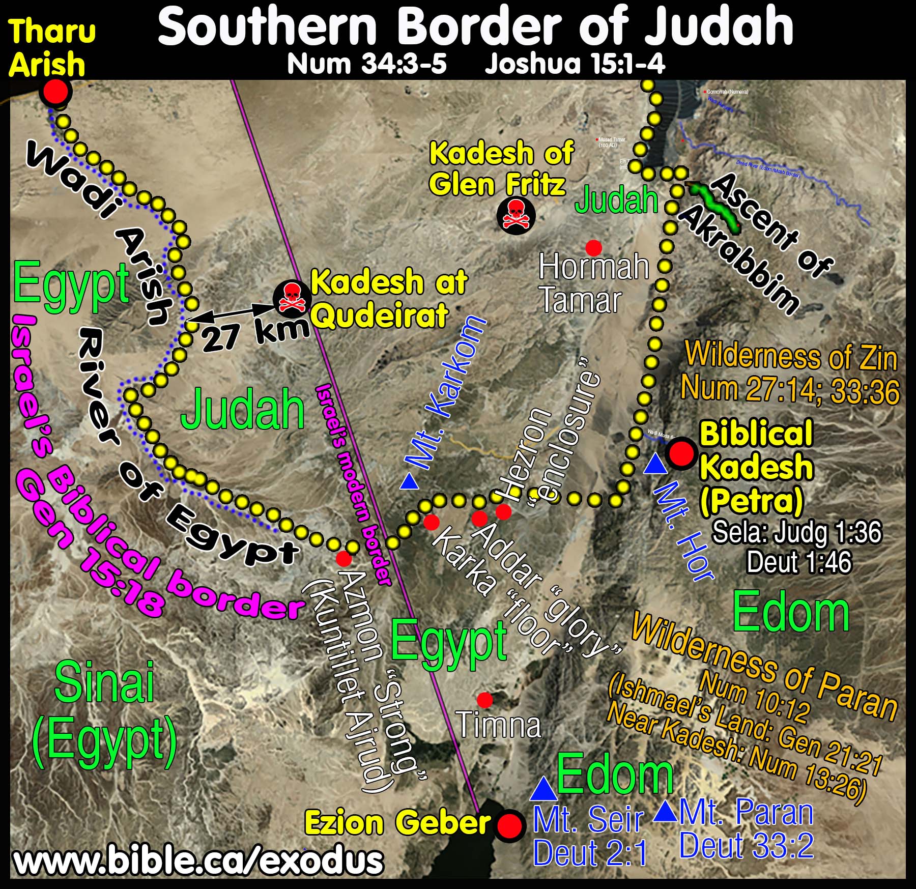
southern border of Judah: 1406 BC
Kadesh Barnea at Petra
|
|
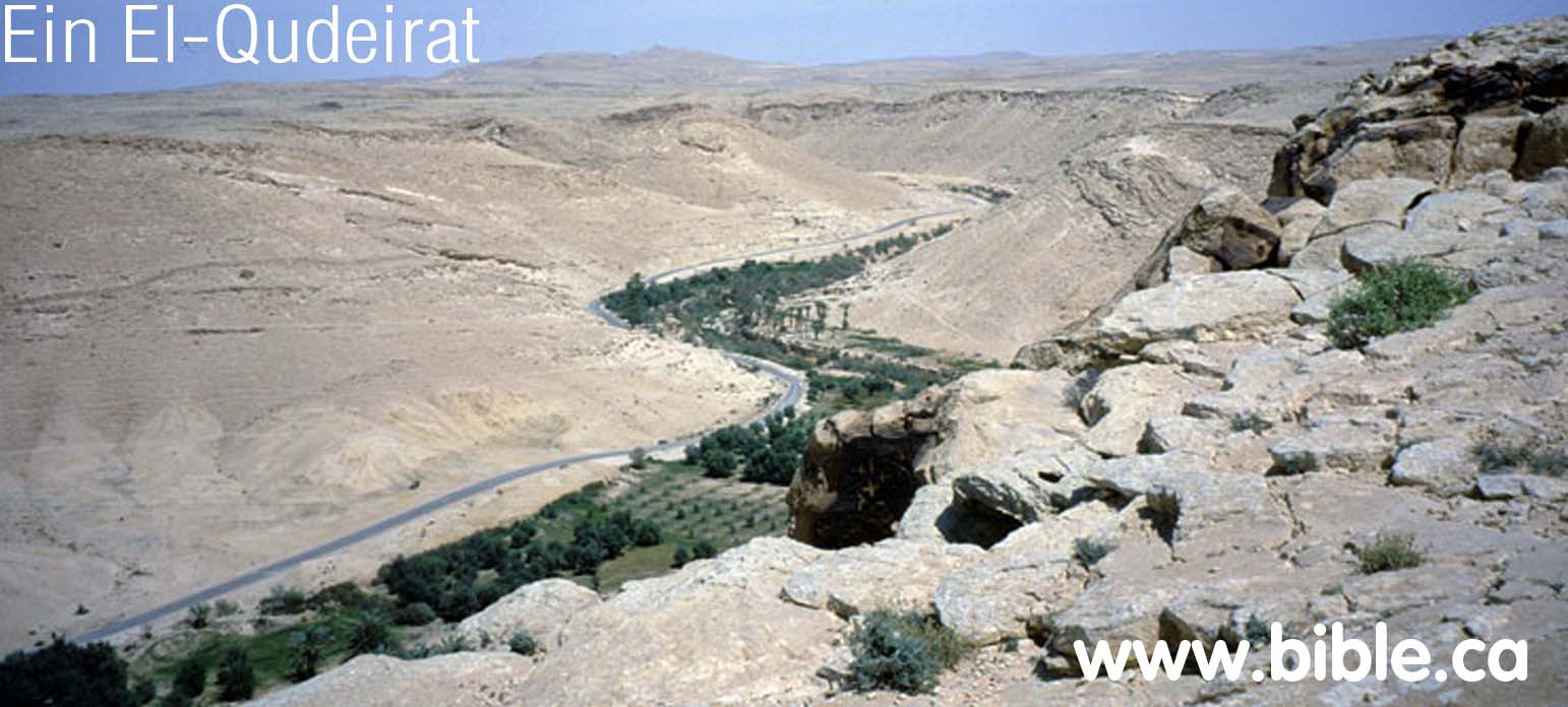
Most maps wrongly place Kadesh at ein el-Qudeirat and draw border line south of Qudeirat. The problem with this should be obvious to anyone who believes the Bible is both inspired and error free. If you draw the border south of Qudeirat, then Kadesh Barnea is inside the promised land! When you correctly place Kadesh where Eusebius said it was located, at Petra, then it all becomes simple and clear. The Brook of Egypt (Wadi el-Arish) is the border between Israel and Egypt.
Numbers
34:3-5 |
|
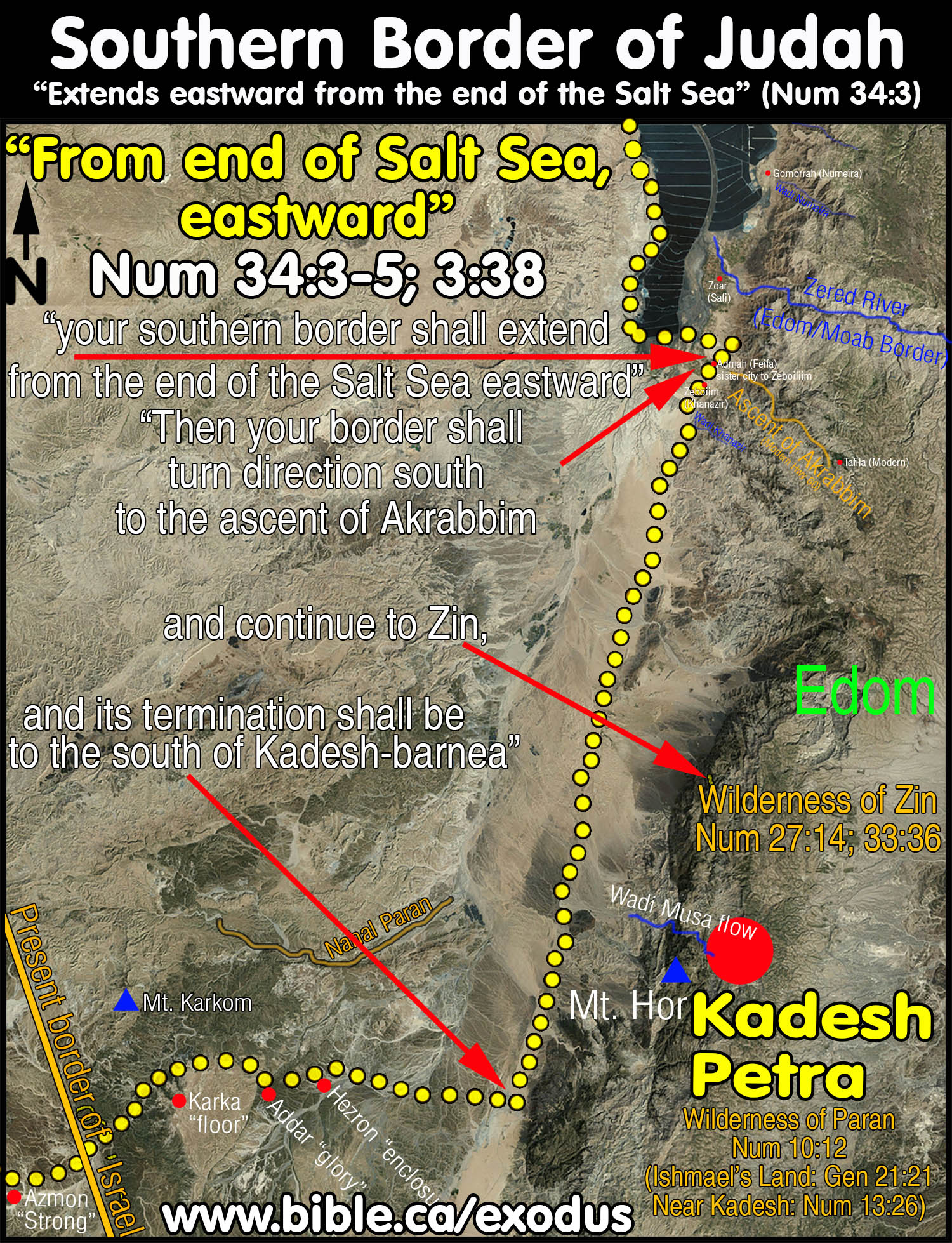
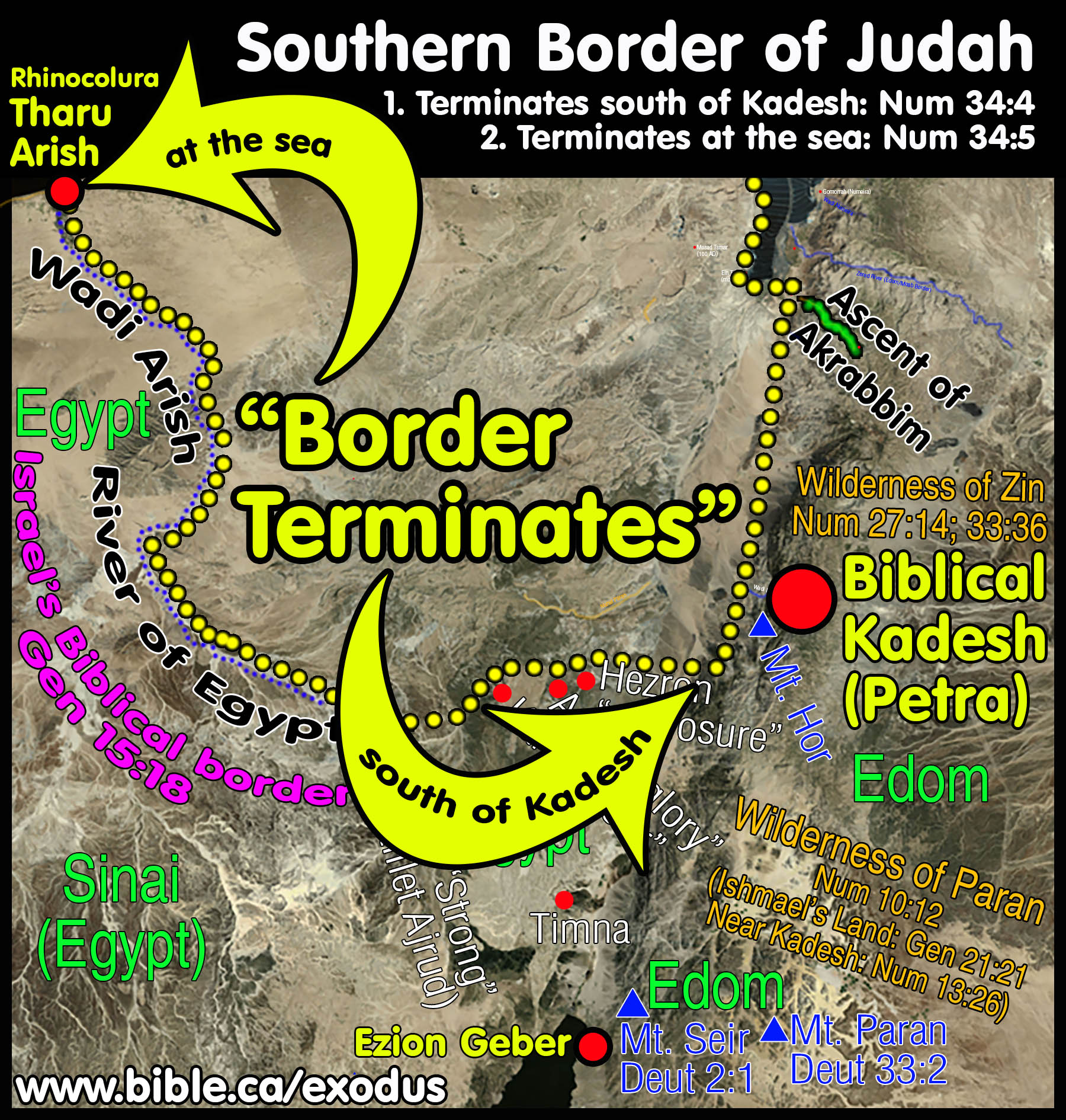
Imagine you are in a car driving on the Bible border of Judah. You start driving at Engedi and follow the western shoreline of the Dead Sea. When you reach the end of the Dead Sea, turn left (East) and start driving towards modern Jordan. Those who wrongly place Kadesh at ein el-Qudeirat must head WESTWARD, not Eastward. They go 180 degrees the wrong direction and head in a straight line through the assent of Akrabbim (wrongly located at Ma'ale Aqrabim on the west side of the Arabah valley), and continue in a straight line through the middle of Judah's territory (which they wrongly call the Wilderness of Zin) and then to complete their comedy of errors, on to ein el-Qudeirat as their choice for Kadesh. But if you drive eastward, as the Bible says, you reach the real "assent of Akrabbim", turn right and drive due south towards the Gulf of Aqaba. Next you pass the Wilderness of Zin on your left (in modern Jordan), but you never actually enter the Wilderness of Zin. Then, as you keep driving due south, you pass Kadesh Barnea (at Petra) on your left. THIS IS THE ONLY WAY KADESH REMAINS OUTSIDE THE BOUNDARY OF THE PROMISED LAND as the Bible says. (Just as the southern boundary of Florida at Miami is south of Houston, so too the southern border of Judah is south of Kadesh. Just as Houston is outside Florida, Kadesh is outside Judah.) After you pass the sign on the road that says, "Kadesh due East on your left" you keep driving SOUTH OF KADESH. A few miles south of Kadesh is where the north/south portion of the border "terminates". The border continues "as far as Kadesh" then changes direction due west, and starts heading for the Brook of Egypt. So as you drive past Kadesh on your left, only then do you make a 90 degree turn to the right and start driving due west towards the River of Egypt. In this way the border "went up south of Kadesh". Placing Kadesh Barnea at ein el-Qudeirat simply cannot harmonize any of these details. Only when Kadesh is located somewhere Transjordan between the Dead Sea and the Red Sea on the eastern side of the Arabah valley, do these details fit perfectly! |
|
|
|
|
|
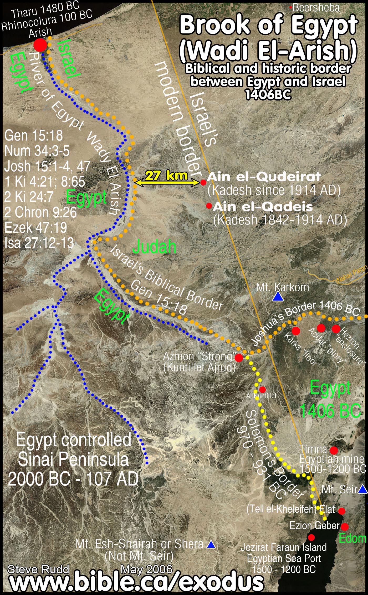
"Your southern sector shall extend from the wilderness of Zin along the side of Edom, and your southern border shall extend from the end of the Salt Sea eastward. 'Then your border shall turn direction from the south to the ascent of Akrabbim and continue to Zin, and its termination shall be to the south of Kadesh-barnea; and it shall reach Hazaraddar and continue to Azmon. 'The border shall turn direction from Azmon to the brook of Egypt, and its termination shall be at the sea. Numbers 34:3-5 |
"Now the lot for the tribe of the sons of Judah according to their families reached the border of Edom, southward to the wilderness of Zin at the extreme south. Their south border was from the lower end of the Salt Sea, from the bay that turns to the south. Then it proceeded southward to the ascent of Akrabbim and continued to Zin, then went up by the south of Kadesh-barnea and continued to Hezron, and went up to Addar and turned about to Karka. It continued to Azmon and proceeded to the brook of Egypt, and the border ended at the sea. This shall be your south border. Joshua 15:1-4 |
|
|
|
Introduction:
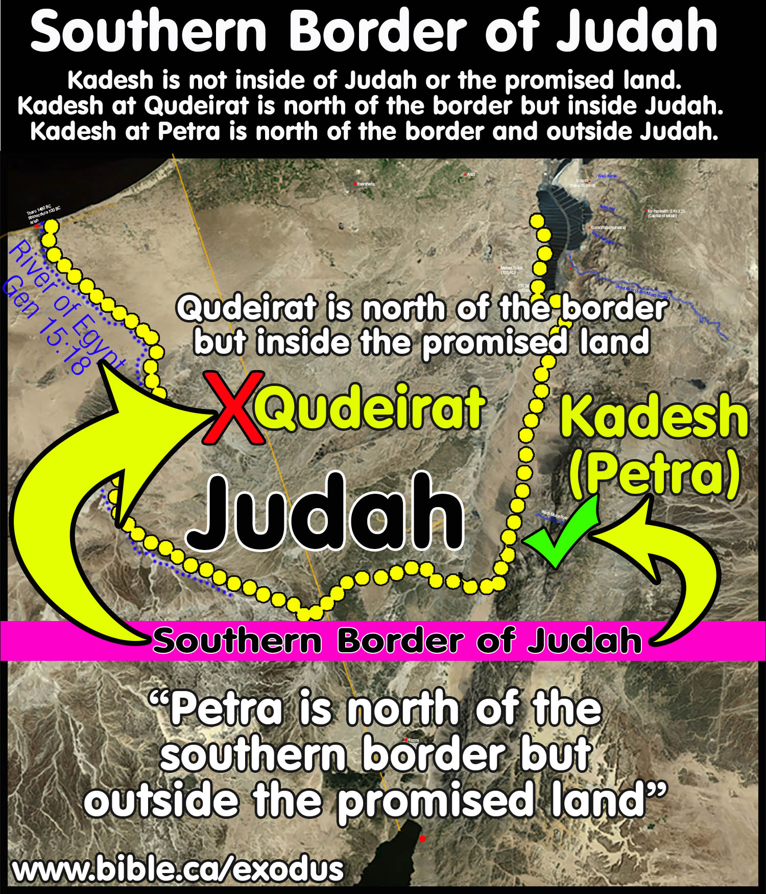
- By correctly mapping the southern border of Judah, we can prove beyond any doubt that Kadesh Barnea was located Transjordan. It all comes down to one critical phrase that everyone misunderstood: The border "goes up south of Kadesh" and "terminates south of Kadesh". (Numbers 34:3-5; Joshua 15:1-4) Since we know Kadesh is not within the promised land, the only place that you can locate Kadesh is on the north-south portion of the southern border, east of the Arabah Valley. Petra fits perfect. If you place Kadesh on the east-west portion of the border at Ein El-Qudeirat, as all maps since 1916 AD have done, then Kadesh is actually inside the promised land. That doesn't work! So if the southern border is drawn so that is runs "south of Kadesh", it must be Transjordan at Petra. To draw the southern border to run south of Qudeirat as all modern Bible maps do, it creates a contradiction with the Bible, that Israel spent 38 years at Kadesh without ever setting foot inside the promised land.
- Almost every Bible map since 1916 AD has made the blunder of locating Kadesh Barnea 27 KM inside the land of Judah at Ein El-Qudeirat. Kadesh Barnea is located Transjordan, at Petra, just like Eusebius wrote in his Onomasticon in 325 AD.
- The location of the southern border of Judah is critically important for determining the exodus route. This is because Kadesh is always mentioned in connection with this southern border. However, the border is completely misinterpreted and drawn incorrectly on almost all bible maps we have seen. Yet the information is right there in the bible and we use scripture to correctly map southern Judah. Only after we have correctly drawn the borders can we know where Kadesh Barnea is located.
- Bible map makers since 1916 AD, begin by placing Kadesh on the map at Qudeirat, then adjusting the borders of Judah accordingly. But since they have chosen the wrong location for Kadesh at Qudeirat, they also wrongly map the wilderness of Zin, the Wilderness of Paran, Mt. Hor, the border of Edom, the border of Egypt, and the Ascent of Akrabbim.
- Although there is a single passage that says Judah's border extended down to the Red Sea (Elat/Ezion Geber), this did not happen until the time of Solomon about 950 BC. In 1406 BC, at the time of the conquest under Joshua, the border bypassed north of Timna, which was under Egyptian control as one of their many mining operations. The Kenites formed a partnership with Egypt from 1406 - 1200 BC, when the mines were abandoned. It appears that Solomon started mining here about 950 BC. It was at this time when the border of Judah moved 80 km south from Kadesh (at Petra) down to the Red Sea. "I will fix your boundary from the Red Sea (Gulf of Aqaba) to the sea of the Philistines, and from the wilderness to the River Euphrates; for I will deliver the inhabitants of the land into your hand, and you will drive them out before you. " Exodus 23:31
- Between 1406 - 950 BC, the southern border does not extent to the Red Sea, Elat or Ezion Geber. If it did it would mention at least one of these in the two main texts that describe the border in the greatest detail. (Numbers 34:3-5; Joshua 15:1-4.) Therefore, we know that as the border ran south from the Dead Sea, it turned west from the Arabah valley before it reached the Red sea. The Bible says that the border changed direction just south of Kadesh (at Petra).
- All locations that make up the southern border are outside Judah. They are never referred to in the normal course of internal events of Judah. Between Kadesh and the Wadi el-Arish, they are never referred to again, being single references. This places them on the outside edge of the border of Judah. These towns are likely controlled by gentiles. The 3 places on the eastern border are all Transjordan: Ascent of Akrabbim, wilderness of Zin and Kadesh Barnea. These locations are all outside Judah. Remember that the place most Bible maps locate Kadesh at, is Qudeirat. Yet Qudeirat is 27 km inside the territory of Judah. It has not dawned upon even the best Bible students, that if Kadesh was located at Qudeirat, then the 38 years in the wilderness was actually in the promised land!
- The fact that there are four cities between Kadesh and the River of Egypt, makes it unlikely that Qudeirat is the correct location of Kadesh. Qudeirat is 27 km from the wadi el-Arish. Qudeirat is 70- 95 km from the Ascent of Akrabbim (depending where you locate Akrabbim).
- If Kadesh was at Qudeirat, then the wilderness of Zin, would be inside the middle of Judah's Territory. Yet we never find any references to the wilderness of Zin in the Bible except in connection with the exodus. This proves that both Kadesh and the wilderness of Zin are Transjordan (at Petra).
- The Ascent of Akrabbim travels Transjordan east from the Arabah Valley up into modern Jordan, and not west into the land of Judah. There are scant references to it in the rest of the Bible. If it was within the land of Judah, as is traditionally suggested today, then we should find several references to it within the normal course of events. But we find this same pattern of lack of references to all the exodus route locations outside the boundaries of Israel: ascent of Akrabbim, Kadesh, wilderness of Zin, wilderness of Paran, Mt. Sinai.
- As a technical note, what the Bible calls the "southern border" is actually composed in part, of the "eastern border" that runs from the south of the Salt Sea towards the Red Sea down to Kadesh. After it passes Kadesh (at Petra) it turns 90 degrees due west to meet the Wadi el-Arish and terminates at the Mediterranean Sea. So the north/south section from the Dead Sea down to Petra and the east/west section that runs from Petra to the Brook of Egypt and to the sea. The two sections of the border are almost perpendicular to each other.
- Additional information:
a. Detailed study of proving the River of Egypt is the historic border between Egypt and Israel.
b. Detailed study proving the Sinai Peninsula was under Egyptian control at the time of the Exodus.
c. Detailed study of the phrase, "out of Egypt" in the Bible.
A. Bible Proof that Kadesh is Transjordan:
We can prove Kadesh is Transjordan from the Bible, when you understand this illustration:
- Illustration: Texas is the promised land and Tampa is north of Brownsville.
- False conclusion: If Tampa is north of Brownsville it is in Texas.
- Truth: Tampa is not in Texas but is located both north of Brownsville and outside the state of Texas.
- Conclusion: Tampa is in Florida and outside the promised land of Texas!
- Application: Judah is the promised land and Kadesh Barnea is north of the southern border of Judah.
- False conclusion: If Kadesh is north of the southern border of Judah it is inside the promised land at Qudeirat.
- Truth: Kadesh is not in Judah but is located both north of the southern border of Judah and outside the promised land.
- Conclusion: Kadesh
Barnea is located at Petra and cannot be located at Qudeirat.
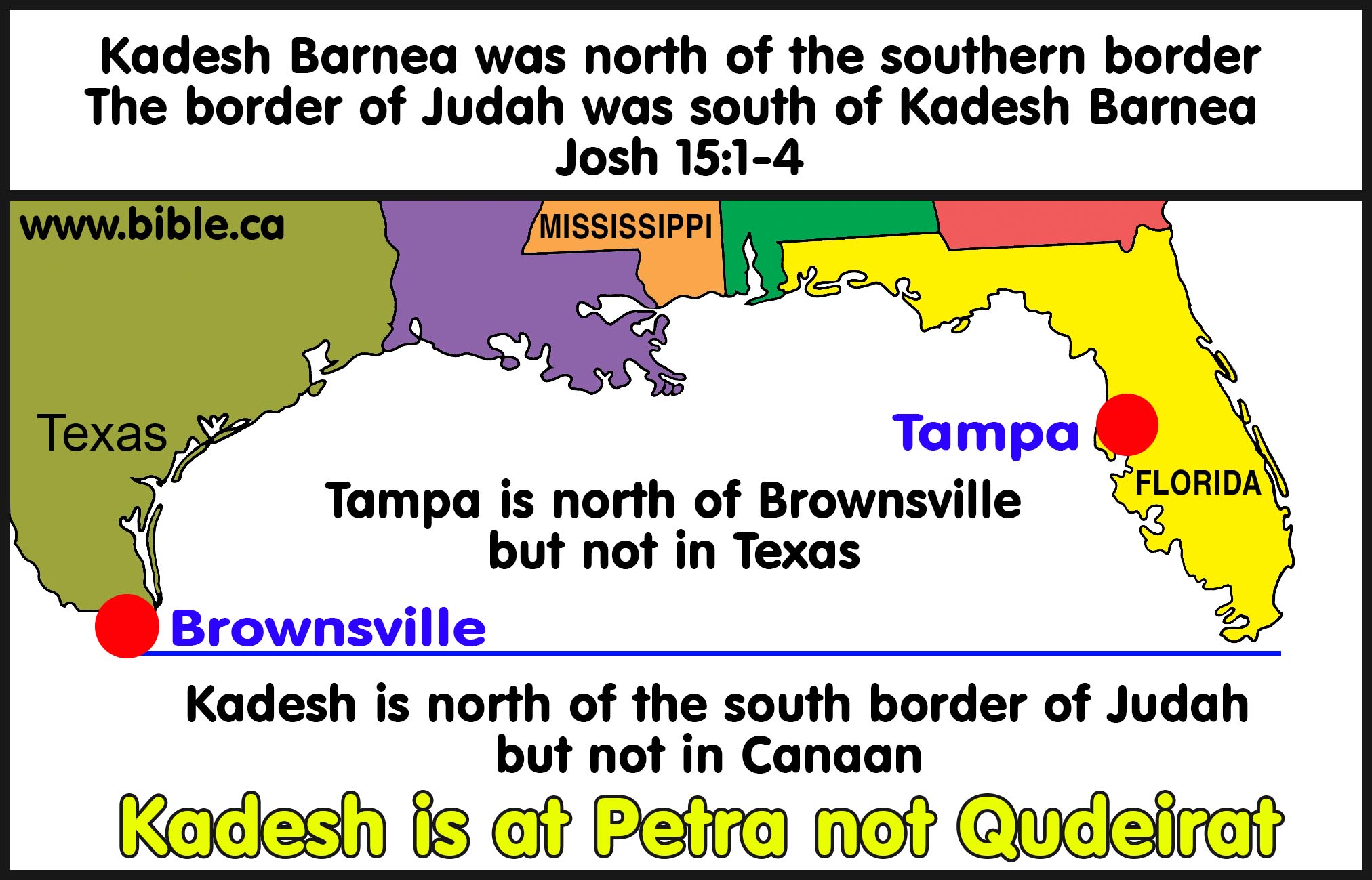
- Kadesh Barnea is located north of the southern boundary line of Judah.
- False conclusion: All bible maps since 1916 AD locate Kadesh Barnea 27 KM inside Judah's southern border at Qudeirat. But this contradicts Bible fact 1 that says Kadesh is not inside the promised land.
- Solution: Kadesh is located Transjordan at Petra, which
is both north of the southern boundary line of Judah and outside Canaan
in modern Jordan.
B. What else the bible says about the borders of all Israel:
It is important to remember that from the time of the conquest in 1406 BC to the time of Solomon, the borders were from Dan in the north down to just south of Kadesh (Petra) in the south. However, for the 40 years Solomon was king, he controlled the section from Petra (Kadesh Barnea) south to the Red Sea (Elat and Ezion Geber) and the northern section from Dan to the Euphrates.
- "Every place on which the sole of your foot treads shall be yours; your border will be from the wilderness to Lebanon, and from the river, the river Euphrates, as far as the western sea." Deuteronomy 11:24
- "I will fix your boundary from the Red Sea [Gulf of Aqaba] to the sea of the Philistines, and from the wilderness to the River Euphrates; for I will deliver the inhabitants of the land into your hand, and you will drive them out before you. " Exodus 23:31
- "Turn and set your journey, and go to the hill country of the Amorites, and to all their neighbors in the Arabah, in the hill country and in the lowland and in the Negev and by the seacoast, the land of the Canaanites, and Lebanon, as far as the great river, the river Euphrates." Deuteronomy 1:7
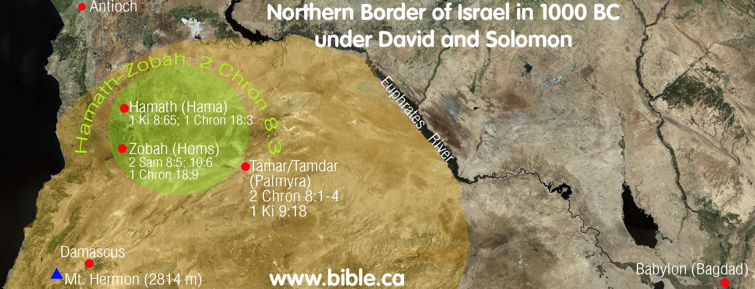
- What is also interesting is that the boundaries of
Solomon's kingdom were from Hamath (Near the Euphrates) to the Wadi el
Arish (river of Egypt):
-"So Solomon observed the feast at that time, and all Israel with him, a great assembly from the entrance of Hamath (Near the Euphrates) to the brook of Egypt, before the Lord our God, for seven days and seven more days, even fourteen days." 1 Kings 8:65
-"David also defeated Hadadezer king of Zobah as far as Hamath, as he went to establish his rule to the Euphrates River." 1 Chronicles 18:3
C. Wadi el-Arish: Biblical border between Judah and Egypt
|
"On that day the Lord made a covenant with Abram, saying, "To your descendants I have given this land, From the river of Egypt as far as the great river, the river Euphrates:" Genesis 15:18.
Key Bible verses: 1. Num 34:3-5 2. Josh 15:1-4, 47 3. 1 Ki 4:21; 8:65 4. 2 Ki 24:7 5. 2 Chron 9:26 6. Ezek 47:19 7. Isa 27:12-13
Border and Brook used interchangeably: 1. Gen 15:18 + 2 Chron 9:26 2. 1 Ki 4:21 + 1 Ki 8:65
|
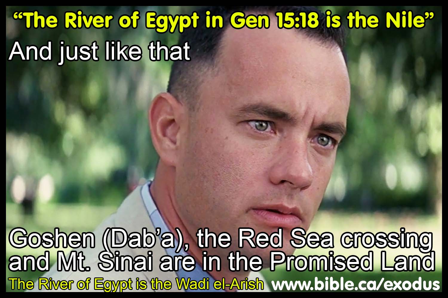
1. The Biblical and historical border between Israel and Egypt has always been the Wadi el-Arish, also known as the River of Egypt. Gen 15:18
a. The River of Egypt IS NOT the Nile River or the Pelusiac arm of the Nile.
b.
Tel el-Dab’a (Goshen) was on the eastern side of the Pelusiac branch of
the Nile, which made it inside the promised land. So, Israel was already inside
the promised land before they left Goshen! If the Pelusiac arm of the Nile is
the southern border of the promised land in Gen 15:18, then Israel was in the
promised land before they crossed the Red Sea and at Mt. Sinai. The land from
the Nile river, the entire modern Sinai Peninsula up to the Wadi el-Arish has
been under Egyptian control from the time of Abraham till the Romans annexed
the Sinai in 106 AD.
2. Esarhaddon (680–669): 10th campaign proves the Brook of Egypt is the Wadi el-Arish:
a. The annal of Esarhaddon says the “Brook of Egypt” is dry without water and he had to supply his troops with buckets of water. A “Wadi” means a river with no water most of the year. The Nile is never dry. The Brook of Egypt is the same as the Wadi el-Arish.
b. “In my [Esarhaddon’s] tenth campaign, I directed my march [against … I ordered … ] towards the country … which is called in the language of the people of Nubia (Kûsu) and Egypt (Muṣur).… I called up the numerous army of Ashur which was stationed in.… In the month of Nisanu, the first month (of the year), I departed from my city Ashur. I crossed the Tigris and the Euphrates at (the time of) their flood; I advanced over the difficult territory (of my route) (as quick-footed) as a wild-ox. In the course of my campaign I threw up earthwork (for a siege) against Ba’lu, king of Tyre who had put his trust upon his friend Tirhakah (Tarqû), king of Nubia (Kûsu), and (therefore) had thrown off the yoke of Ashur, my lord, answering (my admonitions with) insolence. I withheld from them (i.e. the inhabitants of besieged Tyre) food and (fresh) water which sustain life. (Then) I removed my camp from Musru and marched directly towards Meluhha—a distance of 30 double-hours from the town of Apku which is in the region of Samaria (Sa-me-[ri-na]) as far as the town Raphia (in) the region adjacent to the “Brook of Egypt”—and there is no river (all the way)! By means of cords, chains (and) buckets I had to provide water for my army by drawing from wells.” (ANET 292, Esarhaddon)
c. Report on the tenth campaign in the annalistic text British Museum K 3082 + S 2027 + K 3086, published by R. W. Rogers, Haverford College Studies, No. 2 (1889), pp. 65 ff. Translation: H. Winckler, Untersuchungen zur altorientalischen Geschichte (Leipzig, 1889), pp. 97–98; Luckenbill, AR, II, §§554–559.” (ANET 292, Esarhaddon)
3. The entire Sinai Peninsula has been under the control of Egypt from before the exodus in 1446 BC down to the time of Christ. The modern border between Israel and Egypt was determined in 1947 AD with UN resolution 181. This border is utterly irrelevant to the Biblical border. Never in Israel's history has this been the border between Israel and Egypt until 1947 AD. At the time of the Exodus, Israel was not "out of Egypt" until they crossed the Red Sea at the Straights of Tiran and departed from the modern Sinai Peninsula.
- The association of Tharu and Rhinocorura as prison towns where inmates had their noses cut off proves they are the same city at two different time periods. Ancient Egyptian literary sources identify Tharu as having the following markers:
- A Late Bronze age prison camp where inmates had their noses cut off.
- A Late Bronze age Egyptian fortress.
- Located on the border of Egypt as a last stop before entering Canaan at Raphia and Gaza.
- Archaeologists have misidentified ancient Tharu at Tel Habuwa which is located 2 km east of the modern Suez Canal and has no trace of a prison camp.
- The fact the in Isa 27:12 the Septuagint substituted “Rhinocorura” for the “River of Egypt” in 250 BC proves the Biblical border is at the Wadi el-Arish.
- Written in 100 BC, the book of Judith 1:9 proves the brook of Egypt is the Wadi el-Arish: "And to all that were in Samaria and the cities thereof, and beyond Jordan unto Jerusalem, and Betane, and Chellus, and Kades (Kadesh), and the river of Egypt, and Taphnes, and Ramesse, and all the land of Gesem," Judith 1:9
- Foremost, notice that the sequence is 1. River of Egypt, 2. Taphnes, 3. Ramesse, 4. Land of Goshen. Tahpanhes at Tel Defenna (Jeremiah 2:16; 43:7; 43:8) is east of the Pelusiac branch of the Nile River. This proves the Nile is not the River of Egypt.
- “The river of Egypt is likely the wadi of Egypt, Nachal Mizrayim (Num 34:5), also called Wadi el-Arish. It separates Egypt and Judah. Tahpanhes, Rameses, Tanis, and Memphis were major cities in the Nile Delta. Finally, Ethiopia is chosen as the southern boundary.” (Hermeneia, A Commentary on the Book of Judith, Judith 1:9, Lawrence M. Wills, 2019 AD)
- “the brook [lit. “the river”] of Egypt. The Greek probably refers not to the Nile itself but to “the brook [Heb nḥl] of Egypt” (mod. Wadi el-Arish), which geographically separates Palestine and Egypt (cf. 1 Kings 8:65; 2 Chr 7:8; Josh 15:4). In speaking about the brook of Egypt, the Assyrian kings Sargon I and Sennacherib expressly stated there was no water in it (cf. ANET, pp. 286, 290, 292).” (Judith, AYBC, Carey A. Moore, Judith 1:9, 2008 AD)
7. Madaba Map: 600 AD
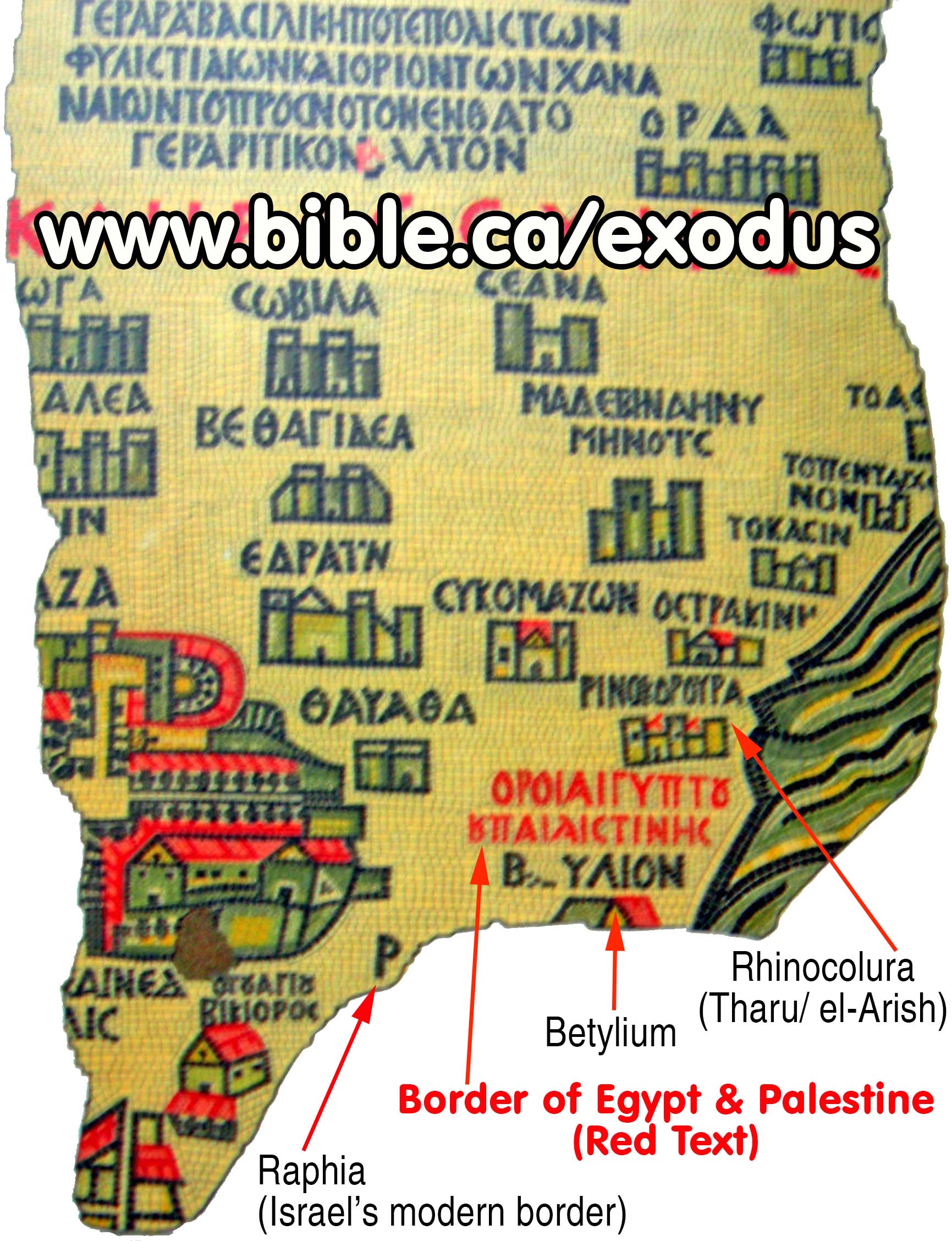
a. The "Madaba map" is a mosaic floor laid in 550 AD. It is in St. George's Orthodox church in the city of Madaba, Jordan.
b. The map is famous because it is one of the oldest maps of Bible lands in the world. It agrees with the "Onomasticon" (dictionary of cities) written by Eusebius in 325 AD.
c. The proof doesn't get much better than this! An actual in situ mosaic we can jump on an airplane today and see for our selves with our own eyes! It is a mosaic that confirms that the Wadi el-Arish is the border between Israel and Egypt.
d. The Madaba map has the words: "Border of Egypt and Palestine" just between the towns of Bitylium and Rhinocolura are the following words in the Madaba Map: Border of Egypt and Palestine "Horoi Aigyptou kai Paleaistines".
e. Detailed study of the Madaba map.
8. Ancient literary sources confirm Wadi el-Arish is the River of Egypt in Gen 15:18
a. 670 BC: Esarhaddon’s 10th campaign says the Brook of Egypt had no water! (ANET 292, Esarhaddon)
b. 250 BC: The Septuagint (LXX): substitutes "the brook of Egypt" in Isa 27:12 for Rhinocorura,
c. 150 BC: Polybius: Rhinocorura is the border of Egypt (Polybius, Histories 5:80)
d. 100 BC: Judith 1:9: River of Egypt is not the Pelusiac branch of the Nile
e. AD 110: Josephus: Simeon borders Egypt (Sinai Peninsula) and Arabia (Petra); Rhinocurura is in Egypt
f. AD 325: The Onomasticon by Eusebius
g. AD 400: Jerome: Raphia is near the border of Egypt (Jerome, commentary on Daniel 11:10-14)
h. AD 542: Madaba Map: States in Greek that Egyptian border is between Raphia and Rhinocorura
- Details: Wadi el-Arish
D. What the bible says about the Brook of Egypt (Wadi el-Arish)
|
Notice the interchangeability between brook of Egypt and border of Egypt! |
|
|
Brook of Egypt |
Border of Egypt |
|
Euphrates to brook of Egypt: Gen 15:18 |
Euphrates to border of Egypt: 2 Chron 9:26 |
|
Solomon ruled to brook of Egypt: 1 Ki 8:65 |
Solomon ruled to border of Egypt: 1 Ki 4:21 |
- "On that day the Lord made a covenant with Abram, saying, "To your descendants I have given this land, From the river of Egypt as far as the great river, the river Euphrates:" Genesis 15:18
- "'The border shall turn direction from Azmon to the brook of Egypt, and its termination shall be at the sea." Numbers 34:5
- "It continued to Azmon and proceeded to the brook of Egypt, and the border ended at the sea. This shall be your south border." Joshua 15:4
- "Ashdod, its towns and its villages; Gaza, its towns and its villages; as far as the brook of Egypt and the Great Sea, even its coastline." Joshua 15:47
- "Now Solomon ruled over all the kingdoms from the River to the land of the Philistines and to the border of Egypt; they brought tribute and served Solomon all the days of his life."
- "So Solomon observed the feast at that time, and all Israel with him, a great assembly from the entrance of Hamath to the brook of Egypt, before the Lord our God, for seven days and seven more days, even fourteen days." 1 Kings 8:65
- "The king of Egypt did not come out of his land again, for the king of Babylon had taken all that belonged to the king of Egypt from the brook of Egypt to the river Euphrates." 2 Kings 24:7
- "He was the ruler over all the kings from the Euphrates River even to the land of the Philistines, and as far as the border of Egypt." 2 Chronicles 9:26
- "The Ammonites also gave tribute to Uzziah, and his fame extended to the border of Egypt, for he became very strong." 2 Chronicles 26:8
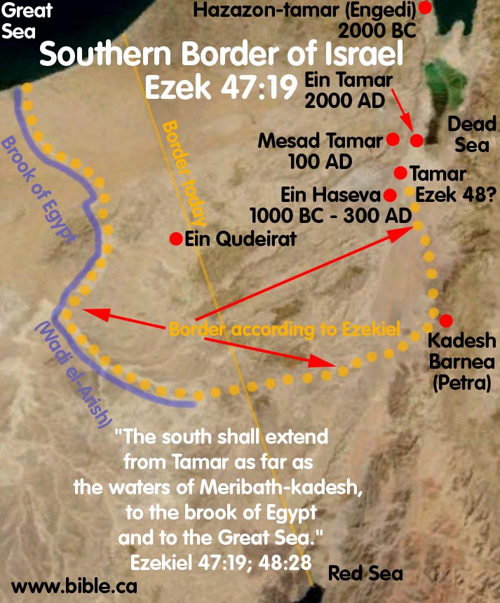
- ""The south side toward the south shall extend from Tamar as far as the waters of Meribath-kadesh, to the brook of Egypt and to the Great Sea. This is the south side toward the south." Ezekiel 47:19
- "In that day the Lord will start His threshing from the flowing stream of the Euphrates to the brook of Egypt, and you will be gathered up one by one, O sons of Israel. It will come about also in that day that a great trumpet will be blown, and those who were perishing in the land of Assyria and who were scattered in the land of Egypt will come and worship the Lord in the holy mountain at Jerusalem." Isaiah 27:12-13
- For more, see: Sinai Peninsula under Egyptian control.
|
Text |
Northern border: Euphrates |
Southern border: Wadi el-Arish |
|
Gen 15:18 |
as the great river, the river Euphrates |
from the river of Egypt |
|
1 Ki 8:65 |
from the entrance of Hamath |
to the brook of Egypt |
|
2 Ki 24:7 |
to the river Euphrates |
from the brook of Egypt |
|
2 Chr 7:8 |
from the entrance of Hamath |
to the brook of Egypt |
|
Isa 27:12 |
from the flowing stream of the Euphrates |
to the brook of Egypt |
|
2 Chr 9:26 |
from the Euphrates River |
as far as the border of Egypt |
|
1 King 4:21 |
from the River |
to the border of Egypt |
|
Jer 2:18 |
to drink the waters of the Euphrates |
to drink the waters of the Shihor? |
|
Ex 23:31 |
to the River Euphrates |
from the wilderness |
E. What the bible says about the border from the Dead Sea down to Kadesh:
- Note that if Kadesh Barnea was located at Qudeirat (where
most maps place it today) it would be within Goshen. This is not the same
Goshen as the one in Egypt. It would mess up the north/south, east/west
co-ordinates of the verse. As an illustration, Josh 10:41 is like
describing four corners of the USA like this: "From New York to
Mexico, from Florida to Washington." But if Kadesh was at Qudeirat,
it would be like saying, "From New York to Mexico, from Manhattan to
Washington." This is why Kadesh must be in a place outside of Goshen.
We know Goshen was in the south central area of Judah. Therefore it makes
perfect sense for Kadesh to be at Petra and not at Qudeirat.
"Joshua struck them from Kadesh-barnea even as far as Gaza, and all the country of Goshen even as far as Gibeon. " Joshua 10:41.
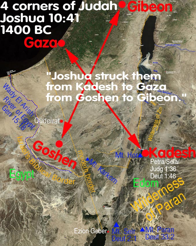
- Like Joshua 10:41 above, Ezekiel 47:19 is another example of how a Bible verse picks four well known N,S,E,W co-ordinates to draw a boundary. What is critical here is that if you make the mistake of wrongly place Kadesh at ein el-Qudeirat it makes mush of the text. That is because Qudeirat is in a direct line towards the Brook of Egypt and two of the four reference points of the compass are essentially the same. Only when you locate Kadesh at Petra do you have a square box with four corners, not a triangle with two dots on one of the three sides. There are four dots on the border in Ezekiel 47:19. This creates a box with four dots in a square. Is makes no sense to have two locations named for a single dot.
- "The south side toward the south shall extend from Tamar as far as the waters of Meribath-kadesh, to the brook of Egypt and to the Great Sea. This is the south side toward the south." Ezekiel 47:19
- "And beside the border of Gad, at the south side
toward the south, the border shall be from Tamar to the waters of Meribath-kadesh, to the brook of
Egypt, to the Great Sea." Ezekiel 48:28
Full discussion of Ezek 47:19 click here.
- "From the End of the Salt
Sea, EASTWARD". Many miss or just ignore this critical
clue as to how to draw the border south of the Dead Sea. It is quite simple.
When you reach the end of the Dead Sea turn EAST, not west, as almost all
bible maps draw it. Most maps wrongly place Kadesh at ein
el-Qudeirat and contradict the Bible's instructions in drawing the
border when you reach the end of the Dead Sea. They wrongly go WESTWARD,
not Eastward. They go 180 degrees the wrong direction and head in a
straight line through the assent
of Akrabbim (wrongly located at Ma'ale Aqrabim on the west side of the
Arabah valley), and continue in a straight line through the middle of
Judah's territory which they then mislabel as the Wilderness
of Zin to ein
el-Qudeirat.
"Your southern sector shall extend from the wilderness of Zin along the side of Edom, and your southern border shall extend from the end of the Salt Sea eastward. 'Then your border shall turn direction from the south to the ascent of Akrabbim and continue to Zin, and its termination shall be to the south of Kadesh-barnea; and it shall reach Hazaraddar and continue to Azmon. 'The border shall turn direction from Azmon to the brook of Egypt, and its termination shall be at the sea." Numbers 34:3-5
- The next important fact in drawing the section of Judah's
border south of the Dead Sea, is to keep going due south, until you pass Kadesh on the East Side. This
is perhaps the biggest error people make in drawing the border. Most maps
wrongly place Kadesh at ein
el-Qudeirat and draw the border line south of Qudeirat. The problem
with this should be obvious to anyone who believes the Bible is both
inspired and error free. If you draw the border south of Qudeirat, then
Kadesh Barnea is inside the promised land! When you correctly place Kadesh
where Eusebius
said it was located, at Petra, then it all becomes simple and clear.
Imagine you are in a car driving on the Bible border of Judah. You start
driving at Engedi and follow the western shoreline of the Dead Sea. When
you reach the end of the Dead Sea, turn left (East) and start driving
towards modern Jordan. When you reach the assent
of Akrabbim, turn right and drive due south towards the Gulf of Aqaba.
Next you pass the Wilderness
of Zin on your left, but you never actually enter the Wilderness of
Zin. Then, as you keep driving due south, you pass Kadesh Barnea on your
left. THIS IS THE ONLY WAY KADESH REMAINS OUTSIDE
THE BOUNDARY OF THE PROMISED LAND as the Bible says. After you pass
the sign on the road that says, "Kadesh due East on your left"
you keep driving SOUTH OF KADESH. A few miles south of Kadesh is where the
north/south portion of the border "terminates".
The border continues "as far as Kadesh"
then changes direction due west, and starts heading for the Brook of
Egypt. So as you drive past Kadesh on your left, only then do you make a
90 degree turn to the right and start driving due west towards the River
of Egypt. In this way the border "went up
south of Kadesh". These three key phrases are telling you
that the direction of the border changes direction south of Petra (Kadesh).
Placing Kadesh Barnea at ein
el-Qudeirat simply cannot harmonize any of these details. Only when
Kadesh is located somewhere Transjordan between the Dead Sea and the Red
Sea on the eastern side of the Arabah valley, do these details fit
perfectly!
"went up by the south of Kadesh-barnea" Josh 15:3
"as far as Kadesh" Ezekiel 47:19
"termination shall be to the south of Kadesh" Num 34:4
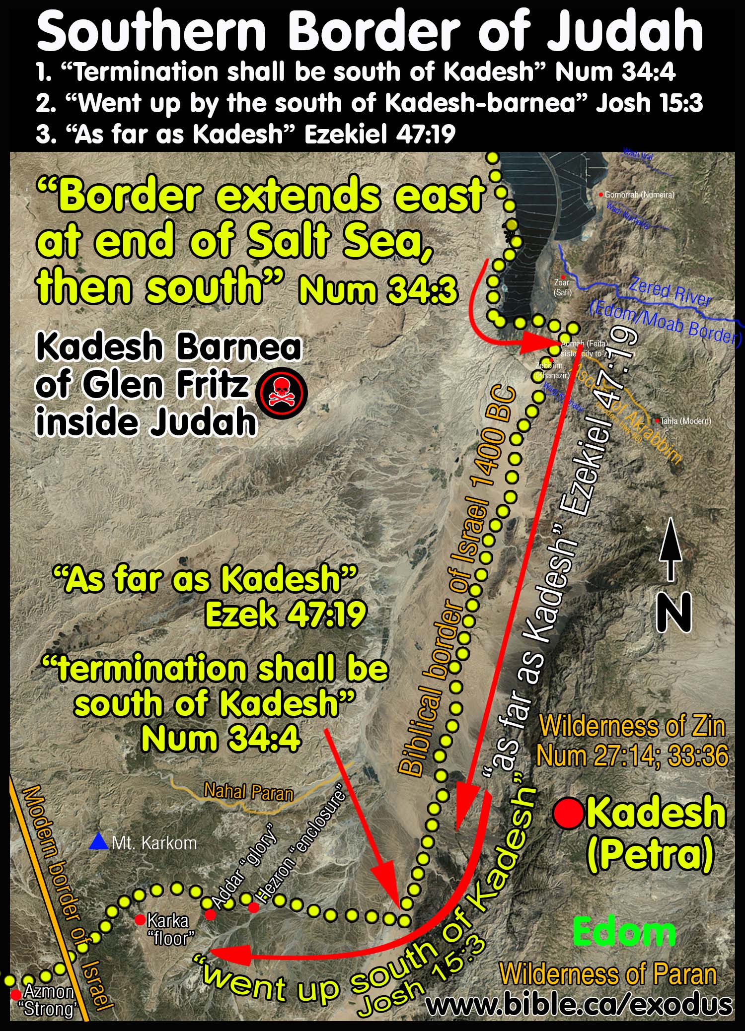
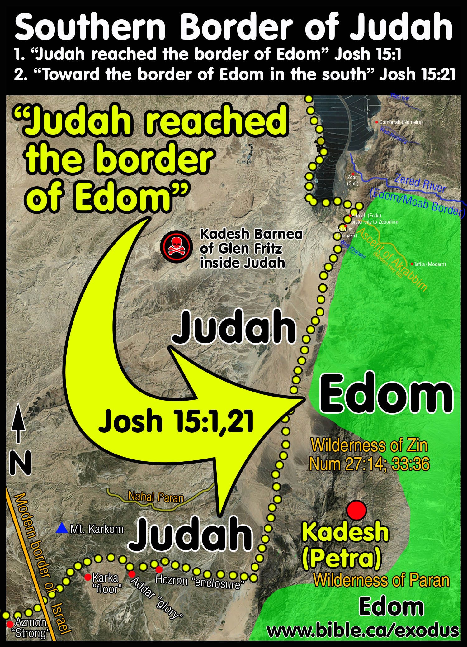
- The next important information comes in relation to the border of Edom.
We know that the Edomites
never lived east of the Arabah valley (in Judah's territory) until the
Babylonian captivity in 586 BC. Their seat of power has always been
Transjordan. We know that Judges 11:15-18 teaches us that Moses sent
messengers from Kadesh to the kings of Moab and Edom and were refused
passage in 1407 BC.
"Judah reached the border of Edom"
"southward to the wilderness of Zin at the extreme south"
"toward the border of Edom in the south" Joshua 15:1, 21
- Numbers 34:3-5 uses the term, "and its termination" twice. First in
reference to the "eastern" portion of the southern border that
travels north/south from the Dead sea to Kadesh at Petra. Then for the
"southern" line that travels east/west and ends at the Sea. Both
these perpendicular sections of the southern border end with the same
phrase, "and its termination shall be". This proves that Kadesh
is on the Transjordan side of the Arabah valley. Imagine you are in a car
and you are at the south end of the Dead Sea. After the short easterly
drive y then start driving south in a straight line which TERMINATES
just south of Kadesh (Petra). Then you turn right and go west until you TERMINATE at the Mediterranean Sea. Two
straight lines, perpendicular to each other with clear termination points.
F. Key locations used in connection with the southern border
The order of cities on the southern border are: Dead Sea, Ascent of Akrabbim, wilderness of Zin, Kadesh Barnea, Karka, Hezron and Addar (Hazaraddar), Azmon, Brook of Egypt.
|
Location |
Mapping Details |
|
Northern border near Babylon |
|
|
Near the Euphrates |
|
|
Arabah Valley |
Valley between Dead Sea and Red Sea. The eastern border of Judah below the Dead Sea. |
|
After the conquest of 1406 BC, this powerful nation of people were displaced Transjordan from Petra north to the Arnon River. The Ascent of Akrabbim is a marker for their border. This proves the Ascent of Akrabbim is also Transjordan. |
|
|
Gaza |
On the coast at north of Raphia |
|
Goshen |
A small territory within southern Judah that bordered on Egypt and the Arabah valley. Not the same as Goshen in Egypt. |
|
Gibeon |
10 km NW of Jerusalem |
|
A small wilderness just north and including Kadesh. |
|
|
Ishmael and the Midianites settled in this large Transjordan wilderness that Kadesh was on the north western edge of modern Saudi Arabia: Genesis 21:21 |
|
|
Transjordan tribe from the Wadi Zered, past Kadesh Barnea at Petra, down to the Red Sea in the mountains. |
|
|
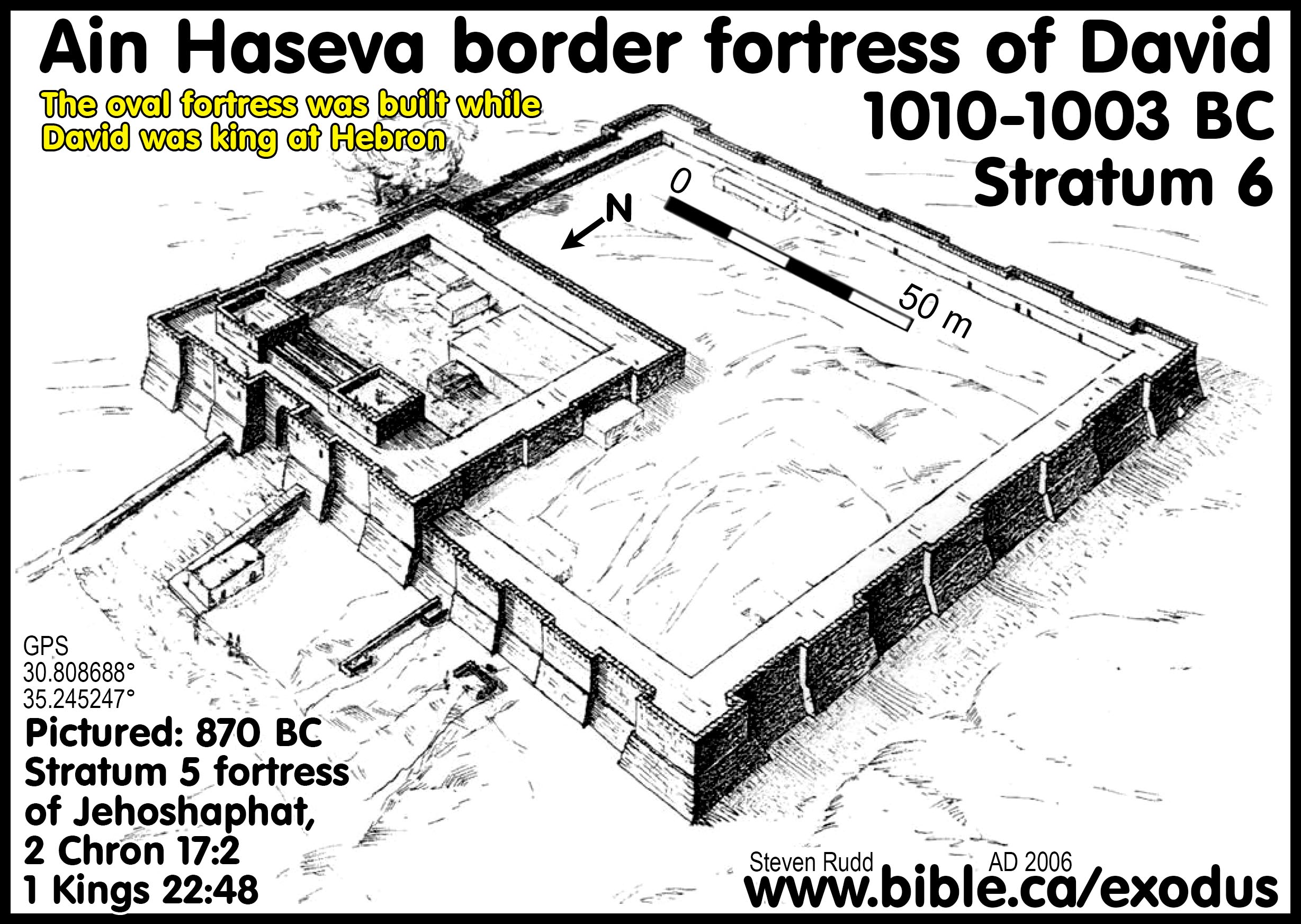
A town located just south of the Dead sea at Ein Haseva. |
|
|
A Transjordan route that led from the Arabah valley east into modern Jordan. |
|
|
Where Israel spent 38 years in the wilderness. Eusebius says Kadesh Barnea was located at Petra. |
|
|
Hezron |
Hezron = literal Hebrew: "surrounded by a wall". (Enhanced Strong's Lexicon) |
|
Addar |
Addar = literal Hebrew: "exceeding glorious". (Enhanced Strong's Lexicon) The phrase "went up to Addar" indicates elevation in the Bible. This means Addar was higher than Hezron. |
|
Hazaraddar |
Hazaraddar is an area that includes these two towns: Hezron and Addar. This means that Hezron and Addar must have been close to each other. Hezron was lower in elevation than Addar. Only used once in the Bible Hazar-addar = literal Hebrew: "enclosure of glory". (Enhanced Strong's Lexicon) |
|
Karka. |
Karka = literal Hebrew: "floor" (Enhanced Strong's Lexicon) "turned about to Karka" indicates the border changed direction or followed some natural contour. Only used once in the Bible |
|
Azmon |
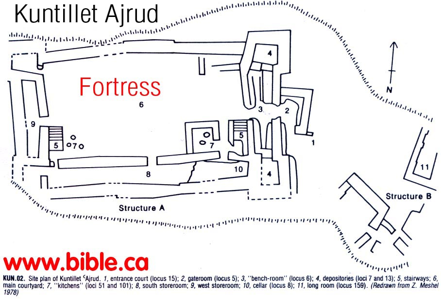
Only 3 references in the Bible. Azmon = literal Hebrew: "strong". (Enhanced Strong's Lexicon) After Azmon, the border changes course towards the Wadi-el-Arish. "The border shall turn direction from Azmon to the brook of Egypt" Kuntillet Ajrud might be the location of the city of Azmon. The famous “YHWH and his consort” ostraca from Kuntillet Ajrud date to around 835 BC which is long after the time of the conquest. This might be a later occupation on top of a Late Bronze age city. We do know that Azmon was near the Wadi and this is a good guess. Being just west of a major trade route junction it matches the idea of being a "strong" fortress. |
|
Wadi el-Arish. Border between Egypt and Israel. The modern town of Arish is the same as Tharu and Rhinocorura where prisoners had their noses cut off and sent to prison at the remotest border of Egypt. |
|
|
Mediterranean Sea |
Western Border |
|
An Egyptian mine from 1500 -1200 BC located 10 KM North-west of Elat. Abandoned till Solomon opened again in 950 BC |
|
|
An ancient town on the eastern shore on the northern tip of the Gulf of Aqaba. It is located somewhere in modern Jordan east of the town of Aqaba. It is where Solomon built a fleet of ships. Ezion Geber is not located at either Elat or the island of Jezirat Faraun. |
G. Cities connected with the southern border of Judah:
- Now the cities at the extremity of the tribe of the sons of Judah toward the border of Edom in the south were Kabzeel and Eder and Jagur, and Kinah and Dimonah and Adadah, and Kedesh and Hazor and Ithnan, Ziph and Telem and Bealoth, and Hazor-hadattah and Kerioth-hezron (that is, Hazor), Amam and Shema and Moladah, and Hazar-gaddah and Heshmon and Beth-pelet, and Hazar-shual and Beersheba and Biziothiah, Baalah and Iim and Ezem, and Eltolad and Chesil and Hormah, and Ziklag and Madmannah and Sansannah, and Lebaoth and Shilhim and Ain and Rimmon; in all, twenty-nine cities with their villages. Joshua 15:21-32
- In the lowland: Eshtaol and Zorah and Ashnah, and Zanoah and En-gannim, Tappuah and Enam, Jarmuth and Adullam, Socoh and Azekah, and Shaaraim and Adithaim and Gederah and Gederothaim; fourteen cities with their villages. Zenan and Hadashah and Migdal-gad, and Dilean and Mizpeh and Joktheel, Lachish and Bozkath and Eglon, and Cabbon and Lahmas and Chitlish, and Gederoth, Beth-dagon and Naamah and Makkedah; sixteen cities with their villages. Libnah and Ether and Ashan, and Iphtah and Ashnah and Nezib, and Keilah and Achzib and Marishah; nine cities with their villages. Ekron, with its towns and its villages; from Ekron even to the sea, all that were by the side of Ashdod, with their villages. Ashdod, its towns and its villages; Gaza, its towns and its villages; as far as the brook of Egypt and the Great Sea, even its coastline. Joshua 15:33-47
H. Solomon's series of Fortresses define the border of Judah:
|
Introduction document: Solomon's network of military border fortresses |
||||||
|
|
|
|
|
|
|
|
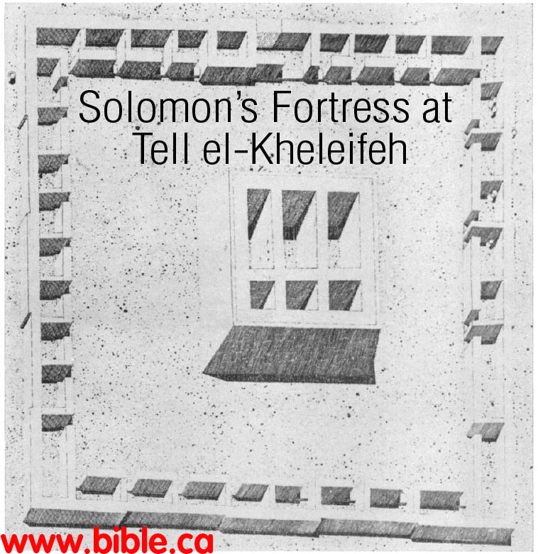
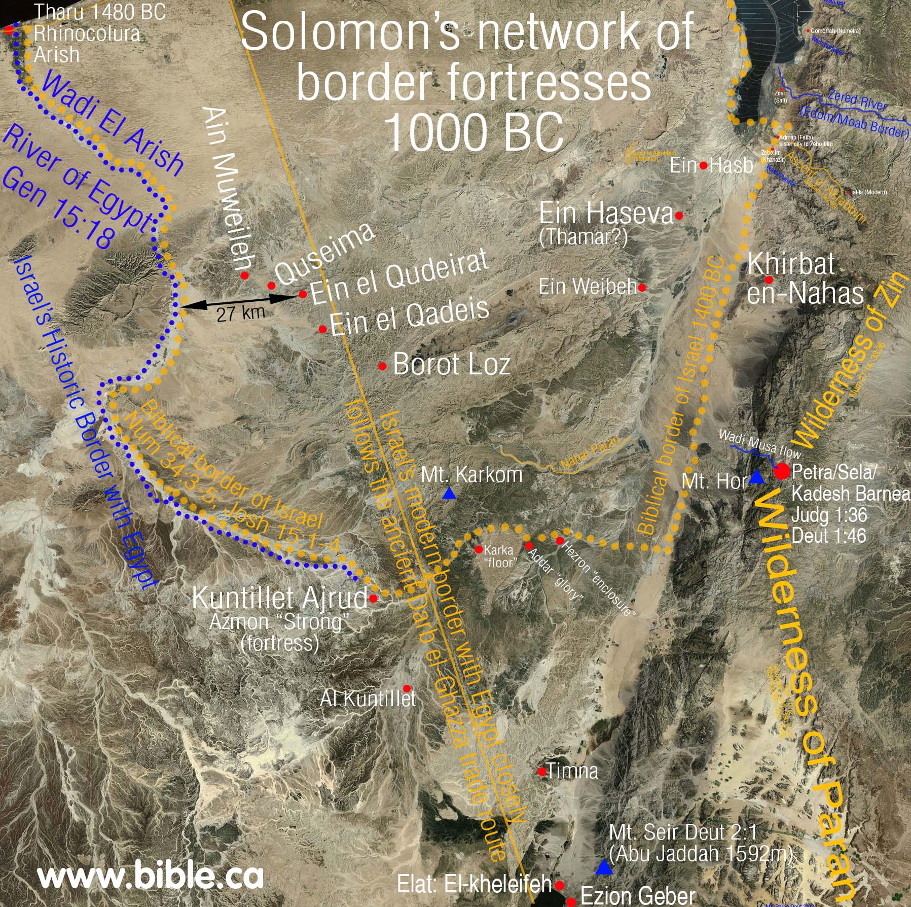
1. Solomon built a network of military fortresses on the outer edge of his border in 950 BC.
2. Although archeologists need absolute proof positive before they come out and say that these fortresses are a way to draw the border of Solomon, we feel that it is quite obvious and beyond doubt or question. Some archeologists do not believe the Bible and openly teach that David and Solomon were not even kings, but mythical figures. They also reject the entire exodus story. You can see the caution and hesitation of the few Bible believing archeologists below who lean towards the fact that these are border fortresses built by Solomon, but simply cannot state it on a professional level. Minimalists have a vested bias again these being built by a David or Solomon because they view them as mythical characters.
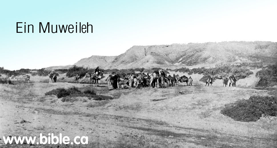
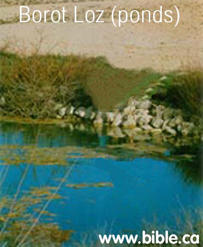
3. At the time of Solomon, Israel's border extended all the way to the Wadi el-Arish. However, after Pharaoh Shishak destroyed the entire network of fortresses, the border moved east to share the water. At that time, Egypt and Israel agreed that the border divided the springs so that each had two, Qudeirat is the location that the Jews built to protect the water at Qudeirat and Kades. Egypt would get the water from the springs at Quseima and Ein Muweileh. It also divided the control of the four ancient trade routes that intersected just west of Qudeirat. So you have the Egyptians on the west of this major crossroads of traffic and two springs completely under their control and the Hebrews on the east of the major crossroads with two springs of their own. Qudeirat represented the western most point of control of the Judean kingdom under Uzzah and Josiah. Qudeirat was the "border town" between Egypt and Israel after 900 BC.
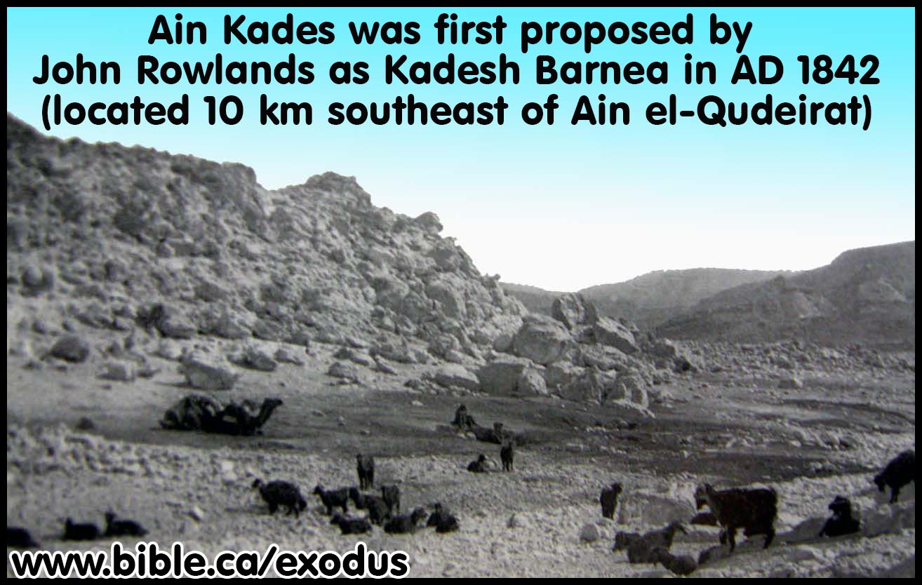
4. Archaeological reports about the excavations at Ein el-Quderat misidentified as Kadesh Barnea:
a. "The earliest fortress on the site was erected seemingly on virgin soil in the 10th-9th centuries B.C.E. Its ground plan, as explained previously, has not been determined, but it evidently belonged to a wide-ranging fortress network then existing in the Central Negev. These fortresses begin near present-day Dimona, continue south past Yeroham and Sede Boger, skirt the edge of the erosion crater of Makhtesh Ramon, and then turn west; here they form a southerly line as far as Kadesh barnea. Dozens of such fortresses have been located since the survey of Woolley and Lawrence, and many have been excavated over the past 12 years—mainly by the author sometimes in conjunction with Z. Meshel (Cohen 1970: 6-24; 1976: 3450; Meshel 1977: 110-35). The fortresses were built according to one of three distinct ground plans—being either roughly oval, rectangular, or square—but clearly belong to the same historical period. In the author's opinion, they were established by King Solomon. As is well known, he was a powerful and energetic ruler, who sought to consolidate the gains of his predecessor, David, by fortifying cities, constructing storehouses, and founding distant trading posts—such as Ezion-geber, on the Red Sea shores. Accordingly, a network of Central Negev fortresses would have served both in protecting the vital overland trade routes and in forming a bulwark against incursions from the south. An interesting parallel exists between this line of fortresses in the Central Negev and the description (Josh 15:1-4) of the southern limits of the tribe of Judah. Thus, these fortresses also define the southern border of Israel at the time of its greatest extent." (Excavations At Kadesh-Barnea: 1976-1978, Ein el-Qudeirat, Rudolph Cohen, 1981 AD)
b. "Notable among these evidences of early human habitation is a series of sites dating to the Iron Age. They invariably consist of some sort of fortress surrounding or adjacent to a small settlement. Yohanan Aharoni identified many of these sites in his Negev survey of the late 1950's and attributed their existence and importance to the need to establish control over the road system of the Negev. Thus, a line of forts was established which would safeguard the lucrative trade routes with South Arabia and East Africa as well as with the various mining operations in the Arabah and Sinai." (Kadesh Barnea: Judah's Last Outpost, Carol Meyers, 1976 AD)
c. Aharoni's work was concentrated upon the road system. Since then and as a result of the Israel Survey, the explorations of Rudolph Cohen, head of the Negev Survey, have given indication that the Iron Age sites provide information not only about trade routes but also about the borders of the Judean kingdom. (Kadesh Barnea: Judah's Last Outpost, Carol Meyers, 1976 AD)
d. A clear grasp of political borders appears in the OT, and the conceptions are similar to those of the ancient Near East as a whole. ... In any case, the Judaean character of the stamps is clear. The relatively limited number of stamps in the Shephelah and Negev makes it hard to use them to define political borders there. (Remains of Late Iron Age Judah in Relation to its Political Borders, Raz Kletter, 1999 AD)
e. Archaeologically, both sites can be defined as fortresses related to public administration; but Qadesh Barnea is similar to other Judaean fortresses, while the plan of Mesad Hashavyahu is unique and no similar fortresses are known from nearby kingdoms. (Remains of Late Iron Age Judah in Relation to its Political Borders, Raz Kletter, 1999 AD)
f. Qadesh Barnea and Mesad Hashavyahu (near Ashdod) cannot help in determining the borders of Judah at present because they are both isolated sites, detached from any other Judaean settlement. A border is defined by a succession or sequence, of the kind found, for example, in the Judaean Shephelah. Qadesh Barnea and Mesad Hashavyahu are situated well outside any sequence of Judaean settlements, like parts of a puzzle that do not combine with other parts. Because they were isolated, it is extremely difficult to assess their political status. Even if we define their material culture as Judaean, this does not necessarily imply Judaean rule over them or over the surrounding area. ... The suggestion that the Judaean presence there is related to vassal service (Na'aman 1989) seems more plausible than the assumption of independent Judaean control. (Remains of Late Iron Age Judah in Relation to its Political Borders, Raz Kletter, 1999 AD)
g. "Isolated Sites: Qadesh Barnea and Mesad Hashavyahu: Qadesh Bamea and Mesad Hashavyahu [near Ashdod] pose a challenge in regard to the definition of Judah's borders. Final reports are not yet published (for preliminary reports see Cohen 1983; Naveh 1962; Reich 1989). Judaean artifacts found at both sites include, for example, inscribed weights, pottery vessels, and Hebrew ostraca. It must be accepted, therefore, that these sites had relations with Judah; but were they governed by Judah as part of its sovereign territory? Mesad Hashavyahu is especially important in this regard, for political control over it would mean access to sea trade routes as well as control over the vital way from Egypt to Phoenicia and Syria along the coastal plain. The material culture of both sites is not purely Judaean, but mixed: Aegean artifacts appear at Mesad Hashavyahu (East Greek pottery) and possibly also coastal artifacts (Reich 1989); "Negbite" wares are known from Qadesh Barnea." (Remains of Late Iron Age Judah in Relation to its Political Borders, Raz Kletter, 1999 AD)
Conclusion:
1. Almost every map in every Bible is riddled with major errors in the Exodus route, the wildernesses of Zin and Paran, the location of Ezion Geber, Kadesh, the ascent of Akrabbim, the territory of the Edomites, Mt Hor and Mt Seir.
a. The reason the borders are drawn incorrectly is because they chose locations for Kadesh Barnea that are Biblically impossible. In other words, Kadesh at Qudeirat directly contradicts the Bible.
b. In their mapping, they always start with Kadesh at Qudeirat, then plot all the other locations in reference to the location of Kadesh.
2. Using the Bible, we can prove Kadesh is Transjordan. Ancient literary sources are united in marking Kadesh Barnea at Petra.
3. Ancient literary sources confirm border of Egypt is at the Wadi el-Arish, the River of Egypt in Gen 15:18
a. See: Brook of Egypt (Wadi el-Arish) is the border between Israel and Egypt.
b. 670 BC: Esarhaddon’s 10th campaign says the Brook of Egypt had no water! (ANET 292, Esarhaddon)
c. 250 BC: The Septuagint (LXX): substitutes "the brook of Egypt" in Isa 27:12 for Rhinocorura,
d. 150 BC: Polybius: Rhinocorura is the border of Egypt (Polybius, Histories 5:80)
e. 100 BC: Judith 1:9: River of Egypt is not the Pelusiac branch of the Nile
f. AD 110: Josephus: Simeon borders Egypt (Sinai Peninsula) and Arabia (Petra); Rhinocurura is in Egypt
g. AD 325: The Onomasticon by Eusebius
h. AD 400: Jerome: Raphia is near the border of Egypt (Jerome, commentary on Daniel 11:10-14)
i. AD 542: Madaba Map: States in Greek that Egyptian border is between Raphia and Rhinocorura
By Steve Rudd: Contact the author for comments, input or corrections.