The Exodus Route: City of Rameses, Land of Goshen
Remarkable recent archeology has confirmed this is the Hebrew town at the time of the Exodus.
|
|
|
|
|

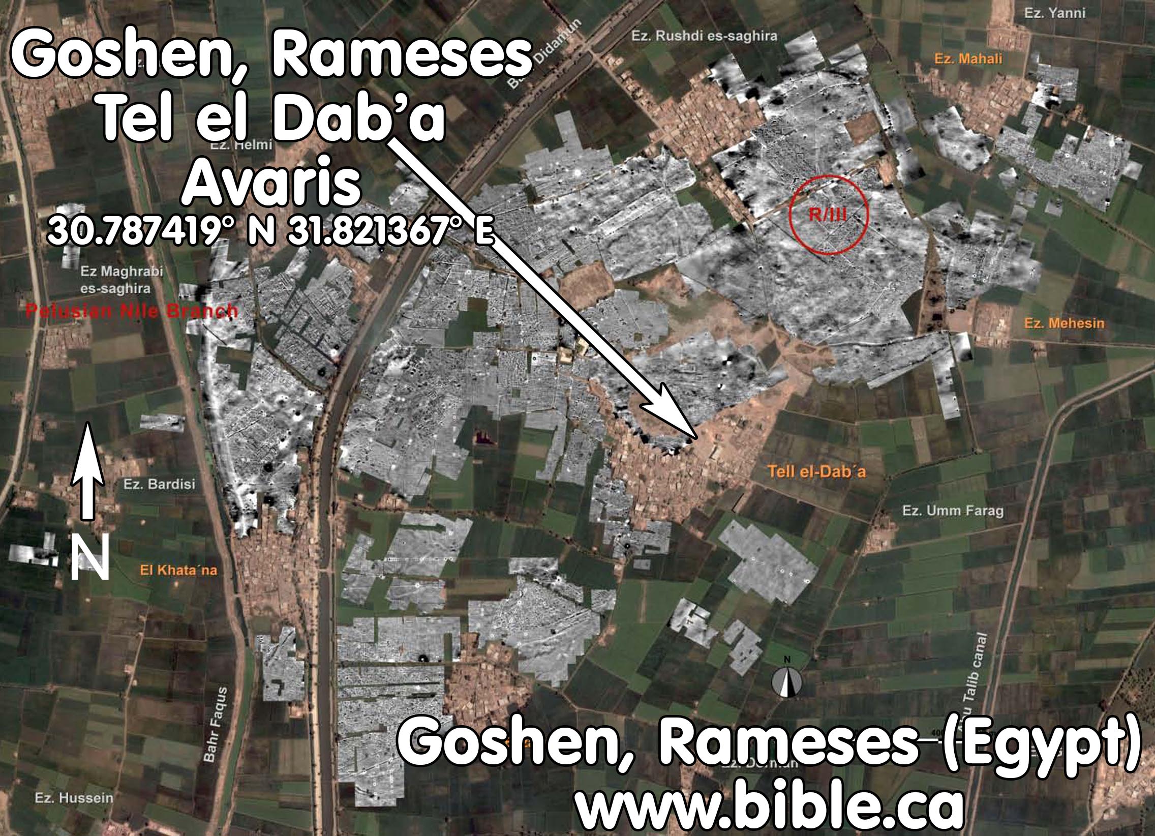
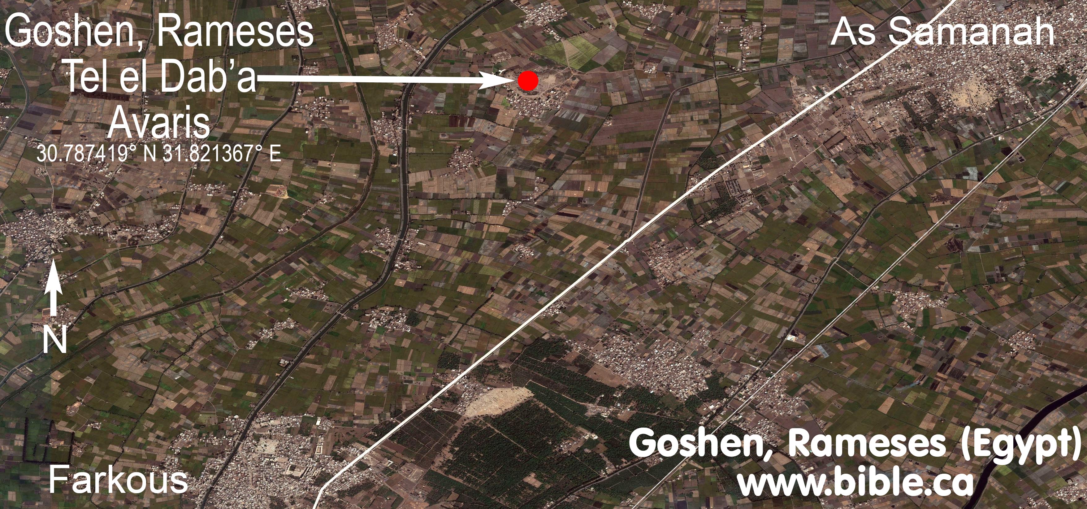
A. The Land of Goshen and City of Rameses (Tel el-Dab'a)
1. The Land of Goshen is where the Hebrews lived for 430 years in Egypt.
a. Rameses was the city of Tel el-Dab’a, also known as Avaris. The archeological site of Tel el Dab'a is located at 30.787419°N 31.821367°E. Located 1 km south of Rushdi, 3 km west of As Samanah, 6 km north of Farkous, 45 km west of the Suez Canal, 80 due south of the Mediterranean Sea.
b. The Land of Goshen was a large territory from Rameses to the Gulf of Suez, south to the Wadi Tumilat and included Ballah lake and Timsah lake.
2. Rameses is listed as the place they departed from as they began the exodus.
a. "So Joseph settled his father and his brothers and gave them a possession in the land of Egypt, in the best of the land, in the land of Rameses, as Pharaoh had ordered." (Genesis 47:11)
b. "Now the sons of Israel journeyed from Rameses to Succoth, about six hundred thousand men on foot, aside from children." (Exodus 12:37)
c.
"They journeyed from Rameses in the first month, on the fifteenth
day of the first month; on the next day after the Passover the sons of Israel started
out boldly in the sight of all the Egyptians," (Numbers 33:3)

3.
Ballah lake and Timsah lake cannot be the Red Sea
crossing site because they are inside Goshen:
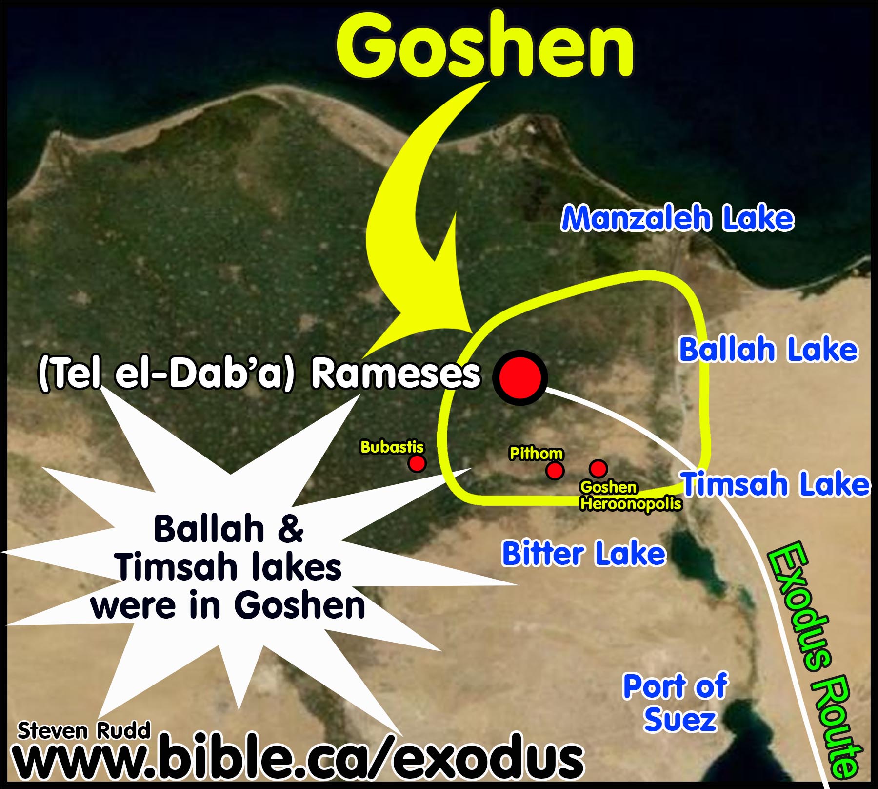
a. These two freshwater lakes would be an important water supply for the 3 million Hebrews who would occupy the entire area from Tel el-Dab’a to the Suez Canal. The lakes were a major food supply of fish for the Hebrew like the Sea of Galilee. It is likely therefore, that the entire shoreline was surrounded and occupied by Hebrews. While Ballah lake and Timsah lake are is 40 km east of Tel el-Dab’a, both lakes were entirely inside the land of Goshen.
b. This has devastating consequences for those who propose a Red Sea crossing at either the Ballah lake or Timsah lake. Imagine the entire lake is surround by Hebrew tents and suddenly Moses brings them to the western shore and parts the sea. On the other side, several of the Hebrews likely ran inside their houses to grab a few more things for the trip to Mt. Sinai! It is impossible for the Hebrews to be trapped at these freshwater lakes.
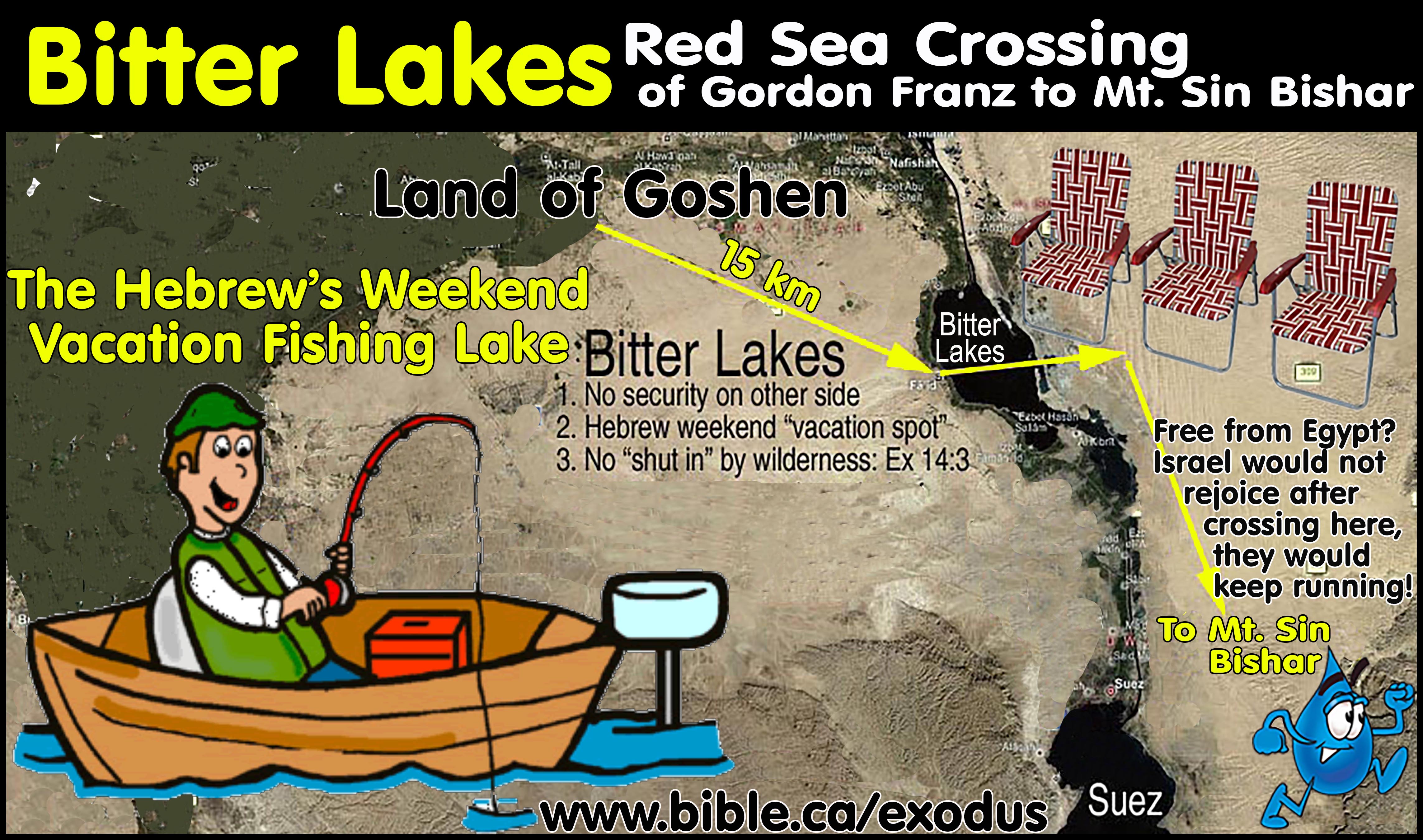
4.
Even the Bitter lakes are so close to Goshen that the
Hebrews would be used regularly by the Hebrews as a commercial fishing center.
B. Sites inside Goshen occupied by Hebrews:
1. Land of Goshen:
a. The land of Goshen extended far east of Tel el-Dab’a all the way to the Suez Canal.
b. Both lake Ballah and Timsah lakes were inside the land of Goshen.
c. Lake Goshen (Lakes of Pithom) in the Wadi Tumilat, the city of Goshen (Heroonpolis = Tell el-Maskhuta) and Pithom (Tell el-Retaba) were all inside the land of Goshen.
d. “GOSHEN: A region in northeast Egypt along the eastern Nile Delta. The extent of the region is uncertain, but it is identified with the area around Wadi Tumilat up to Lake Timsah. The LXX translates “Goshen” as “Gesem of Arabia” (Gen. 45:10) and may identify it with the Egyptian name for Arabia.” (Baker Illustrated Bible Dictionary, Tremper Longman, Goshen, p688, 2013 AD)
2. City of Rameses is Tel el Dab'a (Avaris):
a. The Hebrew city of Tel el-Dab’a might have been located in the middle of the “land of Goshen” or it might have been the western boundary of the land of Goshen. While we are certain Goshen extended east of Tel el-Dab’a, we are unsure if it extended westward towards the central Nile delta area.
b. Located at GPS: 30.787419° N 31.821367°.
c.
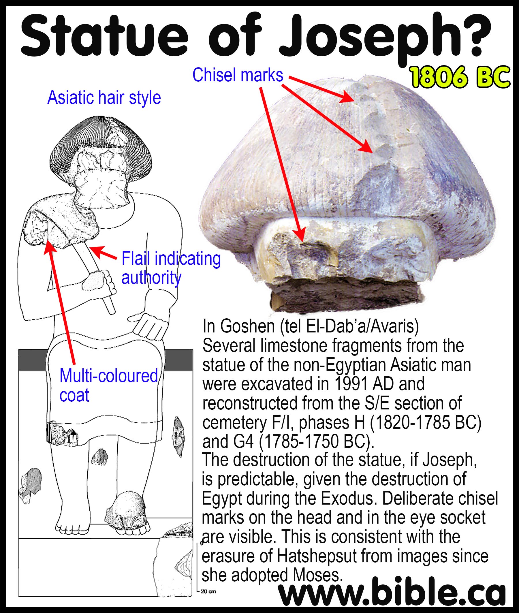
Tel el-Dab’a is where Jacob, Joseph and his
brothers lived and were buried. Excavations by Manfred Bietak discovered a
series of tombs and the famous “Joseph statue” that had been smashed into
pieces. It was occupied by the Hyksos as an administration center. At the time
of the Exodus it was the Egyptian palace beside the Nile river where Moses was
placed in a basket and found by Hatshepsut.
3. City of Goshen is Heroonpolis at Tell el-Maskhuta:
a. The Septuagint changes Goshen in the Masoretic text to Heroonpolis in Genesis 46:28-29. The top Jewish scholars in 282 BC translated the Hebrew into Greek in Alexandria believed Heroonpolis was where 3 million Hebrews lived at the time of Moses.
b. “The Septuagint of Genesis 46:28–29 changes Goshen to Heroonpolis and appears to locate the land of Goshen at Wadi Tumilat. Heroonpolis is most likely identifiable with Tell el-Maskhuta.” (On the Historicity of the Exodus: What Egyptology Today Can Contribute to Assessing the Biblical Account of the Sojourn in Egypt, Manfred Bietak, Israel's Exodus in Transdisciplinary Perspective, Editor-Thomas E. Levy, p21, 2015 AD)
4. City of Pithom is Tell el-Retaba:
a. Located at in the Wadi Tumilat at the eastern shore of lake Goshen.
b. “Pithom in the Bible can be identified with the only known settlement of the Ramesside Period in the Wadi Tumilat, at Tell el-Retaba, not with Tell el-Maskhuta which according to the archaeological record did not yet exist.” (On the Historicity of the Exodus: What Egyptology Today Can Contribute to Assessing the Biblical Account of the Sojourn in Egypt, Manfred Bietak, Israel's Exodus in Transdisciplinary Perspective, Editor-Thomas E. Levy, p31, 2015 AD)
5. Wadi Tumilat:
a. The Wadi Tumilat was Goshen at the time of the Exodus.
b. “The land of Goshen is generally identified with the area around Wadi Ṭumilât, a 56 km. (35 mi.) fertile strip of land connecting the eastern part of the Nile River Delta with Lake Timsah. It provides one of only two passages for traffic between Egypt and Sinai or Palestine to the east.” (Eeardman’s Bible dictionary, Goshen, Daniel Browning, p521, 2000 AD)
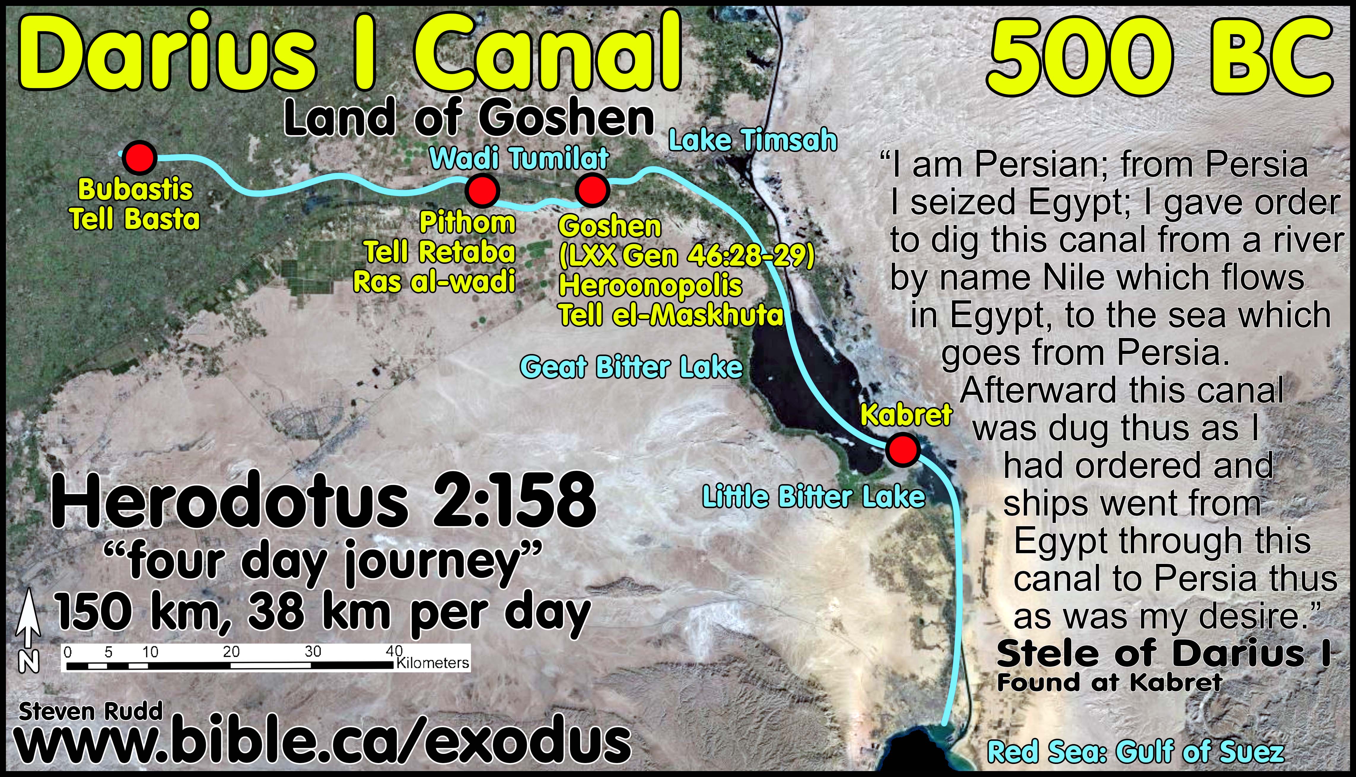
c.
In 500 BC, Darius I completed the Suez Canal that ran from the Nile
through the Wadi Tumilat to the Gulf of Suez:
C. Four anachronistic updates in the Septuagint:
In 282 BC 70 top Hebrew scholars were sent from Jerusalem to Alexandria to translate the Torah from Hebrew into Greek at the request of Ptolemy II for his father’s Library of Alexandria and the result is the Septuagint (LXX). The translation of the Septuagint was the seed that spawned the Synagogue system in 280 BC in Alexandria when spiritually thirsty diaspora Jews gathered in homes to read their new Greek Torah for the first time in their lives and pray to YHWH. Since Hebrew had been was extinct among the Jewish population since 500 BC, this became the standard “pulpit Bible” in the thousands of synagogues all around the world and was used exclusively in Judea at the time of Christ and the Apostles. Only the Temple Sadducees continued to speak Hebrew in their worship services to an Aramaic and Greek speaking audience the same way Roman Catholics today use Latin in English speaking audiences. These Jerusalem Temple approved scholars were the ones who anachronistically updated the ancient Hebrew place-names to reflect their current name. They updated 4 Bible verses that are helpful for us today in understanding the Exodus Route. Lake Goshen, also known in Egyptian inscriptions (Papyrus Anastasi VI:4) as Lakes of Pithom and was located in the Wadi Tumilat, as was the city of Goshen (Heroonpolis = Tell el-Maskhuta) and Pithom (Tell el-Retaba), all of which were inside the land of Goshen. During the 430 years of Egyptian captivity, the Hebrews enjoyed great prosperity because Goshen included the lake at Wadi Tumilat which intercepted imported goods from the Red Sea. Likewise Rameses (Tel el Dab’a) intercepted goods as an end port for the coastal trade route called the Way of the Philistines. During the Babylonian captivity, the Arabians moved into key trading city locations like Rhinocolura/Arish and Goshen. During the Persian kingdom Darius I dug the Suez canal through the Wadi Tumilat from the Nile river at Bubastis down to the Gulf of Suez. This became a major trade route which the Arabians came to dominate. Herodotus in 484 BC records how Pithom was populated by Arabians. "Arabian town of Patumus [Pithom, Tell el-Retaba]" (Herodotus, History 2.158.2). During the Greek kingdom when the Septuagint was translated, the Arabians continued to populate the land of Goshen around the Wadi Tumilat. It is not surprising that the Hebrew translators made anachronistic substitutions to reflect the contemporary reality of Arabian control of key trade route cities like Heliopolis. The translators updated these four passages:
a. Septuagint adds “of Arabia” to “Goshen” in Gen 45:9-10
b. Septuagint substitutes “Heliopolis” for “Goshen” in Gen 46:28-29
c. Septuagint adds “On which is Heliopolis” in Ex 1:10
d. Septuagint substitutes “Rhinocolura” for “Brook of Egypt” in Isaiah 27:13
1. Septuagint adds “of Arabia” to “Goshen” in Gen 45:9-10:
|
Septuagint adds “of Arabia” to “Goshen” in Gen 45:10 |
|
|
Masoretic Hebrew Text |
Septuagint Greek Text |
|
MT: "You shall live in the land of Goshen." (Gen 45:10, MT) |
LXX: "You will dwell in the land of Goshen of Arabia." (Gen 45:10, LXX) |
a. “Hurry and go up to my father, and say to him, ‘Thus says your son Joseph, “God has made me lord of all Egypt; come down to me, do not delay. “You shall live in the land of Goshen, and you shall be near me, you and your children and your children’s children and your flocks and your herds and all that you have." (Genesis 45:9–10, MT)
b. "Therefore, hurrying, go up to my father and say to him, ‘This is what your son, Joseph, says: “God has made me lord of all the land of Egypt. So, come down to me, and do not remain there. And you will dwell in the land of Goshen of Arabia, and you will be near me, you and your sons and the sons of your sons, your sheep and your oxen, even as many things as to you there are." (Genesis 45:9–10, LXX 282 BC)
2. Septuagint substitutes “Heliopolis” for “Goshen” in Gen 46:28-29
|
Septuagint substitutes “Heliopolis” for “Goshen” in Genesis 46:28-29 |
|
|
Masoretic Hebrew Text |
Septuagint Greek Text |
|
MT: " Joseph, to point out the way before him to Goshen" (Gen 46:28-29, MT) |
LXX: " Joseph to meet him down in the City of Heroes in the land of Rameses." (Gen 46:28-29, LXX) |
a. The city of Goshen was in the land of Goshen and was called Heliopolis or Heroonopolis, which means “City of Heros” and is located at Tell el-Maskhuta.
b. "Now he sent Judah before him to Joseph, to point out the way before him to Goshen; and they came into the land of Goshen. Joseph prepared his chariot and went up to Goshen to meet his father Israel; as soon as he appeared before him, he fell on his neck and wept on his neck a long time." (Genesis 46:28–29, MT)
c. "He sent Judah before them to Joseph to meet him down in the City of Heroes [Heliopolis] in the land of Rameses. Joseph, having harnessed his chariots, went up to a meeting with Israel, his father, at the City of Heroes and, seeing him, he fell upon his neck, and he wept with rich weeping." (Genesis 46:28–29, LXX, 282 BC)
3. Septuagint adds “On which is Heliopolis” in Ex 1:10:
|
Septuagint adds “On which is Heliopolis” in Ex 1:10 |
|
|
Masoretic Hebrew Text |
Septuagint Greek Text |
|
MT: "And they built for Pharaoh storage cities, Pithom and Raamses." (Ex 1:10, MT) |
LXX: "So they constructed fortified cities for Pharaoh, both Pithom, Rameses, and On, which is Heliopolis." (Ex 1:10, LXX) |
a. Heliopolis or Heroonopolis means “City of Heros” and is located at Tell el-Maskhuta and is the city of Goshen which was in the land of Goshen on the north shore of the Wadi Tumilat.
b. “Come, let us deal wisely with them, or else they will multiply and in the event of war, they will also join themselves to those who hate us, and fight against us and depart from the land.” So they appointed taskmasters over them to afflict them with hard labor. And they built for Pharaoh storage cities, Pithom and Raamses." (Exodus 1:10–11, MT)
c. “Come, therefore, let us deal shrewdly with them, lest they multiply greatly, and in case war may happen to us, these people also will reinforce our enemies, and, defeating us in war, they will go forth out of the land.” And so he placed over them supervisors of the works in order that they could afflict them in their labors, and so they constructed fortified cities for Pharaoh, both Pithom, Rameses, and On, which is Heliopolis. Exodus 1:10–11, LXX, 282 BC)
4. Septuagint substitutes “Rhinocolura” for “Brook of Egypt” in Isaiah 27:13, echoing Gen 15:18:
|
Septuagint substitutes “Rhinocolura” for “Brook of Egypt” in Isaiah 27:12 |
|
|
Masoretic Hebrew Text |
Septuagint Greek Text |
|
MT: "flowing stream of the Euphrates to the brook of Egypt." (Isaiah 27:12, MT) |
LXX: " channel of the river as far as the Rhinocolura. " (Isaiah 27:12, LXX) |
a. "In that day the Lord will start His threshing from the flowing stream of the Euphrates to the brook of Egypt, and you will be gathered up one by one, O sons of Israel." (Isaiah 27:12, MT)
b. "And this will happen on that day: God will fence in the people from the channel of the river as far as the Rhinocolura. But as for you, gather the children of Israel one by one." (Isaiah 27:12, LXX)
c. "On that day the Lord made a covenant with Abram, saying, “To your descendants I have given this land, From the river of Egypt as far as the great river, the river Euphrates:" (Genesis 15:18)
d. Here we have direct evidence that the Wadi el-Arish is the history southern border of the promised land. This rules out Ain el-Qudeirat as Kadesh Barnea found in every map found in the back of Bibles and Mt. Karkom as Mt. Sinai.
D. Archeological evidence of Israel in Egypt: Lake Goshen
![]()
1. Goshen included Wadi Tumilat and lake Timsah:
a. “But even more conclusive than this is the situation in Goshen during the reign of Thutmose III as compared to that which existed under Rameses II. In the time of Rameses, some of his main building activity was right in the region of Wadi Tumilat, or Goshen, and this meant that Egyptians must have been living all around this region and in the midst of it as well. But the details of the plagues of flies, of hail, and of darkness (Ex. 8:22; 9:25–26; 10:23) make it clear enough that Goshen was at the time of the Exodus inhabited almost exclusively by the Hebrews, and plagues which befell the rest of Egypt made no appearance at all in Goshen. So far as we can tell from the archaeological evidence presently at hand, there were no Egyptians living there during the reign of Thutmose.” (A Survey of Old Testament Introduction, Gleason Archer, p246, 1994 AD)
b. “Leaving the Negeb at Beer-sheba (Gen. 46:1), Jacob and his sons journeyed across the Sinai entering Egypt near Succoth in the Wadi Tumilat. Asiatic shepherds and merchants coming from southern Canaan and Transjordan used this route extensively. The family entered the “land of Goshen” (Gen. 46:28; 47:6), once anachronistically called the “land of Rameses” (Gen. 47:11), located in the northeastern Delta of Egypt. Some scholars have identified Goshen more specifically with the Wadi Tumilat, a fertile finger of the Delta jutting out into the Sinai Desert.” (Holman Bible Atlas, p50, 1998 AD)
c. “The Septuagint clearly identified the land of Goshen and the route of the Exodus with the Wadi Tumilat. … Another interpretation of the Exodus route in the Septuagint (Exod. 1:11)—originally most likely to be a gloss that found its way into the main text—seems to lead from Heliopolis, thought to be Pithom (Pi-Atum), to the Gulf of Suez and the Red Sea.” (On the Historicity of the Exodus: What Egyptology Today Can Contribute to Assessing the Biblical Account of the Sojourn in Egypt, Manfred Bietak, Israel's Exodus in Transdisciplinary Perspective, Editor-Thomas E. Levy, p21, 2015 AD)
d. “During prehistoric times (before 3200 BC), the Nile’s easternmost branch once passed through the Wadi Tumilat. Stretching 31 mi (52 km) from just west of modern Zagazig (ancient Bubastis) to Ismailiya (on Lake Timsah), it created a portion of the eastern edge of the Nile delta. While the course of this delta branch disappeared in historic times, and the present eastern branch is significantly further to the west, both historical and archaeological evidence indicate that ancient canals were cut from the Nile River eastward through the Wadi Tumilat. This ancient watercourse apparently continued to flood periodically throughout history with the overflow of the Nile’s annual flooding. Thus, the Wadi Tumilat may have been one of the reasons that the Isthmus of Suez became known for its marshy fresh water lakes and associated “reeds” (twf). The Wadi Tumilat was no doubt part of the Biblical Land of Goshen.” (New Evidence From Egypt on the Location of the Exodus Sea Crossing, Gary Byers, Bible and Spade, p19, 2006 AD)
e. “There are areas at the eastern borders of Egypt that had Semitic toponyms used even by Egyptian scribes. This situation can only be reasonably explained by assuming that Semitic-speaking people inhabited such areas during the New Kingdom. One has to mention particularly in this respect Wadi Tumilat, which would fulfill in every respect the model of the land of Goshen (or the land of Ramses) in the Bible.” (On the Historicity of the Exodus: What Egyptology Today Can Contribute to Assessing the Biblical Account of the Sojourn in Egypt, Manfred Bietak, Israel's Exodus in Transdisciplinary Perspective, Editor-Thomas E. Levy, p30, 2015 AD)
2. Goshen was centered at “Lake Goshen” or the “Lakes of Pithom” in the Wadi Ṭumilât:
a.
“One wonders if under such evidence Wadi Tumilat could not be deemed,
with all due reservation, a paradigm for the biblical scenario of the land of
Goshen (Gen. 45:10; 46:28–29, 34; 47:1, 4, 6, 27; 50:8; Exod. 8:18; 9:26).
Indeed, Sarah I. Groll cautiously postulated the identification of a possible Egyptian rendering of the biblical toponym Goshen in Papyrus
Anastasi IV (1b:1–2) referring to a stormy lake by the name of gsm in
association with waves. This name gsm seems to have been used as a toponym and
is considered to have been most probably a Semitic
loanword. It is in this connection that it is most important to note
that, in the Septuagint translation of the Pentateuch
into Greek, this name seems to be retained as Γεσεμ
(Gesem). The lake must have been a wide stretch of water. This would fit
in perfectly with the western part of Wadi Tumilat with its large overflow
lake.” (On the Historicity of the Exodus: What Egyptology Today Can
Contribute to Assessing the Biblical Account of the Sojourn in Egypt, Manfred Bietak,
Israel's Exodus in Transdisciplinary Perspective, Editor-Thomas E. Levy, p21,
2015 AD)
see also (Groll Sarah, Israelit. 1998. The Egyptian Background of the
Exodus and the Crossing of the Reed Sea: A New Reading of Papyrus Anastasi
VIII. In Jerusalem Studies in Egyptology, A¨ AT, vol. 40, ed. I. Shirun-
Grumach, 173–192. Wiesbaden: O. Harrassowitz.)
b. “We have allowed the tribes of the Shasu of the land of Atuma to pass the stronghold of King Menephtah of the land of Succoth, towards the lakes of Pithom of King Menepthah of the land of Succoth, in order to feed their cattle in the great farm of Pharaoh,” (Papyrus Anastasi vi. 4)
c. “However, one has to wonder in this context why the toponym the “Lakes of Pithom” is referred to by Egyptian scribes with the Semitic loanword b-r-k-w.t in syllabic writing and not with its Egyptian name. This is indeed remarkable. We gain the suspicion that this word had become something of a toponym in a region inhabited long enough by a Semitics peaking population to supplant the original Egyptian name with an idiomatic expression of their own. In support of this proposition, the point needs to be made that, in the Onomasticon Amenope (Amenemopet), word no. 33 b-r-k-t is followed by no. 34 hnty(w) “borderland,” “frontier”— which would be a meaningful association. Furthermore another Semitic expression s-g-r is used for an enclosure or a fortification of a fortress in the same region (papyri Anastasi V.19, 7). Even Tjeku, the name of the region of Wadi Tumilat, is regarded by many as an Egyptian rendering of the biblical Sukkot. All of this could be viewed as some evidence that this borderland had been settled by a Semitic-speaking population.” (On the Historicity of the Exodus: What Egyptology Today Can Contribute to Assessing the Biblical Account of the Sojourn in Egypt, Manfred Bietak, Israel's Exodus in Transdisciplinary Perspective, Editor-Thomas E. Levy, p21, 2015 AD)
E. Archeological evidence of Israel in Egypt: Tell El-Dab'a
1. "Ancient Rameses is located at Tell el-Dab’a in the eastern Delta, approximately 100 km northeast of Cairo. In antiquity, the Pelusiac branch of the Nile flowed past the site, giving access to the Mediterranean. In addition, the town lay on the land route to Canaan, the famous Horus Road. Thus, it was an important commercial and military center." (The Sons of Jacob, New Evidence for the Presence of the Israelites in Egypt, Bryant G. Wood, Bible and Spade, p53, 1997 AD)
2. "We can divide the history of the site into three periods: pre-Hyksos, Hyksos and post-Hyksos. The Hyksos were a Semitic people from Syria-Palestine, who took up residence in the eastern Nile Delta and eventually ruled northern Egypt for some 108 years, ca. 1663–1555 BC (15th Dynasty). Jacob and his family arrived in Egypt around 1880 BC, based on an Exodus date of ca. 1450 BC. That was in the pre-Hyksos period when the name of the town was Rowaty, “the door of the two roads” (Bietak 1996: 9, 19). In the 14th Dynasty, toward the end of the 18th century BC, the name of the town was changed to Avaris, “the (royal) foundation of the district” (Bietak 1996: 40). When the Hyksos later established their capital there, they retained the name Avaris. It was probably the Hyksos rulers who forced the Israelites to build the store cities of Pithom (= Tell el-Maskhuta) and Rameses (= Tell el-Dab’a = Avaris) (Ex 1:11). When Rameses II rebuilt the city in the 13th century in the post-Hyksos period, and long after the Israelites had left Egypt, the name was changed to Rameses." (The Sons of Jacob, New Evidence for the Presence of the Israelites in Egypt, Bryant G. Wood, Bible and Spade, p53, 1997 AD)
3. "Could this be the Israelites? The earliest evidence for Asiatics at Rowaty occurs in the late 12th Dynasty (mid 19th century BC, Area F/I, Str. d/2, and Area A/II, Str H). At that time a rural settlement was founded. It was unfortified, although there were many enclosure walls, most likely for keeping animals. The living quarters consisted of rectangular huts built of sand bricks (Bietak 1986: 237; 1991b: 32). It is highly possible that this is the first material evidence of Israelites in Egypt. It is the right culture in the right place at the right time. Not all residents of the first Asiatic settlement at Tell el-Dab’a lived in huts. One of them, evidently an important official, lived in a small villa. The Bible tells us that Joseph became a high official after he correctly interpreted Pharaoh’s dreams (Gn 41:39–45). We are not told where Joseph lived while serving in the Egyptian bureaucracy. It seems logical to assume, however, that after discharging his duties associated with the famine, he would have moved to Rameses to be near his father and brothers. Could the villa in Str. d/2 at Tell el-Dab’a have been Joseph’s house?" (The Sons of Jacob, New Evidence for the Presence of the Israelites in Egypt, Bryant G. Wood, Bible and Spade, p53, 1997 AD)
By Steve Rudd: Contact the author for comments, input or corrections.