The Exodus Route: The Etham Backtrack
Etham
Hb. šûr = “wall” and Egyptian htm = “wall, fortress”.
"Shut in by wilderness"
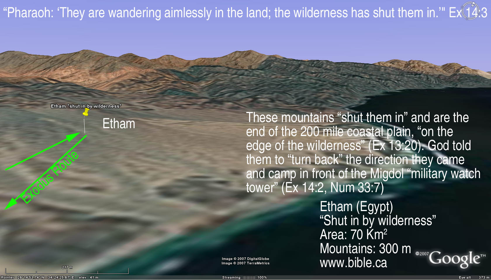
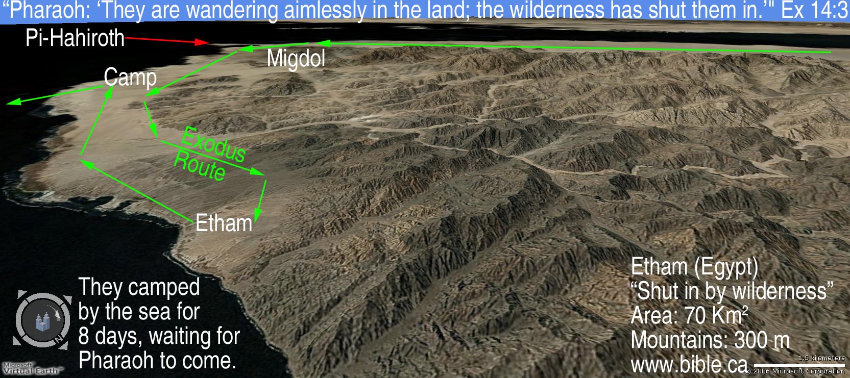
"Now the Lord spoke to Moses, saying, "Tell the sons of Israel to turn back and camp before Pi-hahiroth, between Migdol and the sea; you shall camp in front of Baal-zephon, opposite it, by the sea. "For Pharaoh will say of the sons of Israel, 'They are wandering aimlessly in the land; the wilderness has shut them in.'" Exodus 14:1-3
|
|
|
|
|

Introduction:
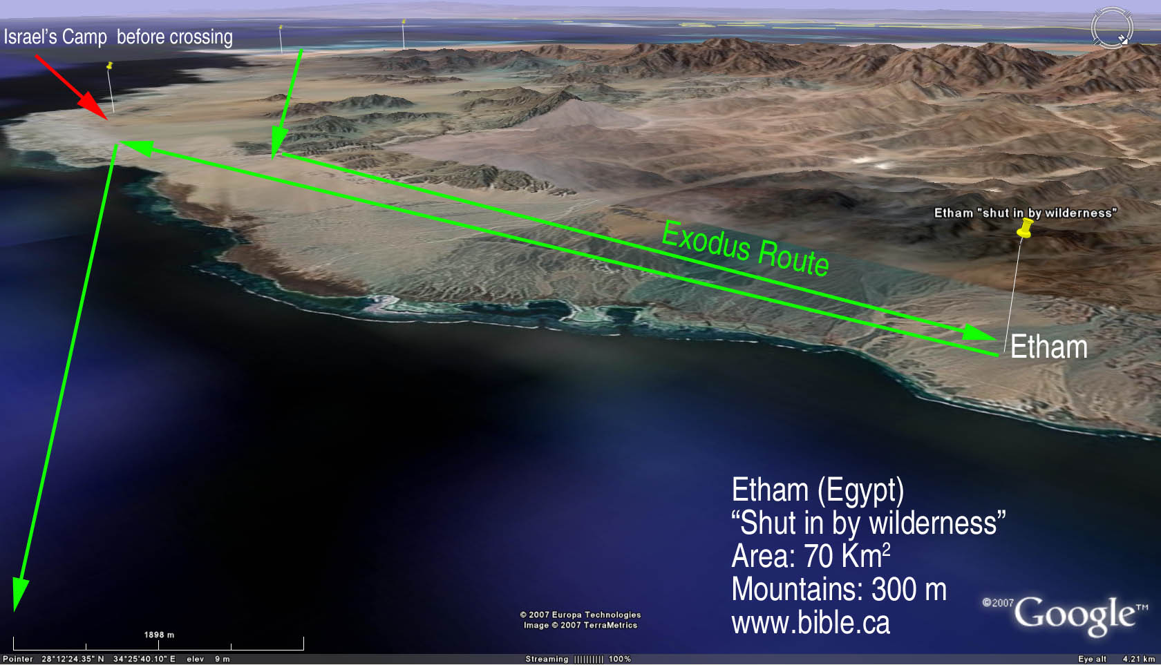
- Etham is one of the most interesting and most important locations for determining the exodus route and the crossing of the Red Sea.
- Pharaoh said: "They are wandering aimlessly in the land; the wilderness has shut them in." Ex 14:3
- Philo also illustrates that at Etham, they were trapped by the wilderness:
- "and not being able to escape, for behind was the sea, and in front was the enemy, and on each side a vast and pathless wilderness" (Philo, On the Life of Moses, 1:165-171)
- " the prophet saw that the whole nation was now enclosed like a shoal of fish" (Philo Moses II 250)
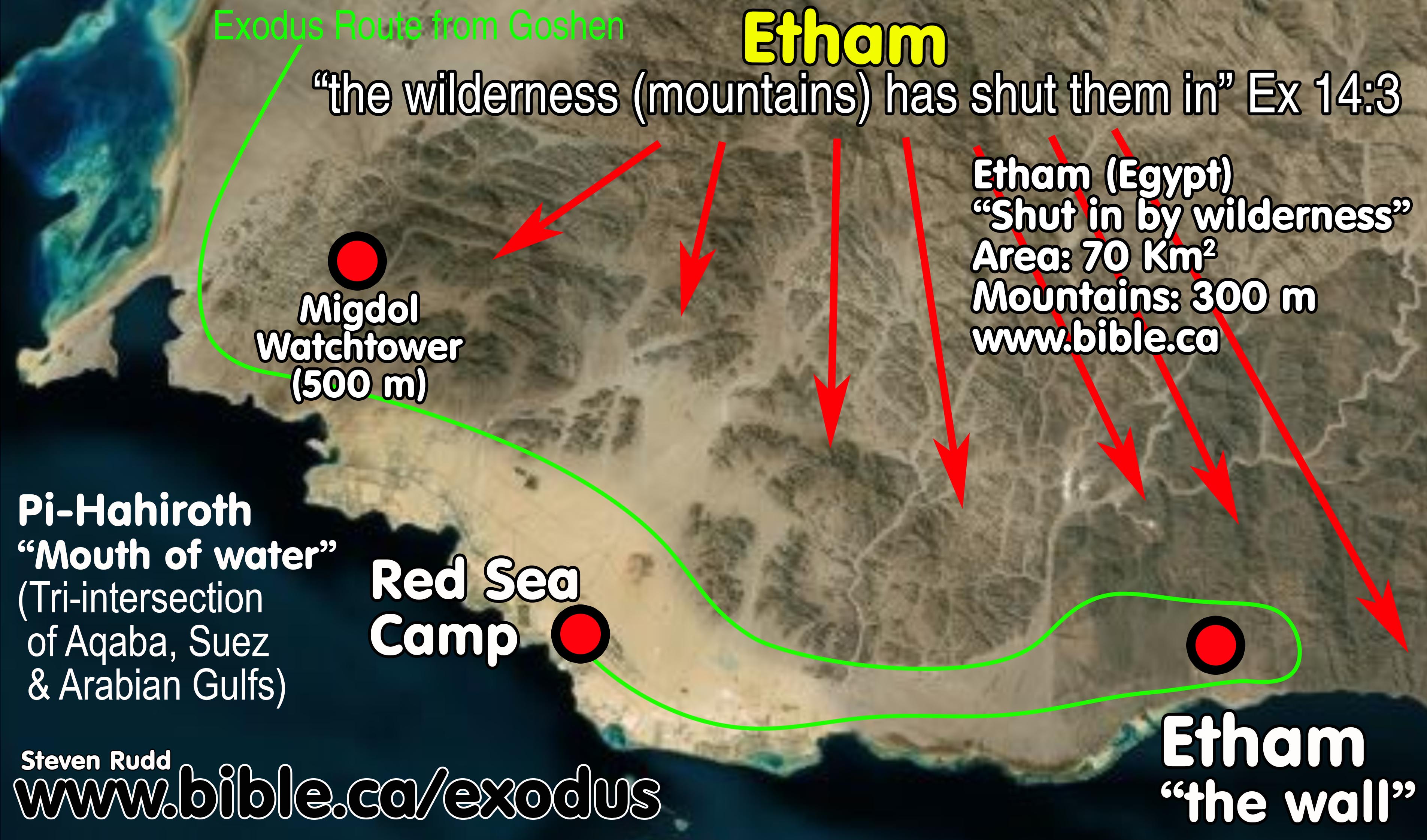
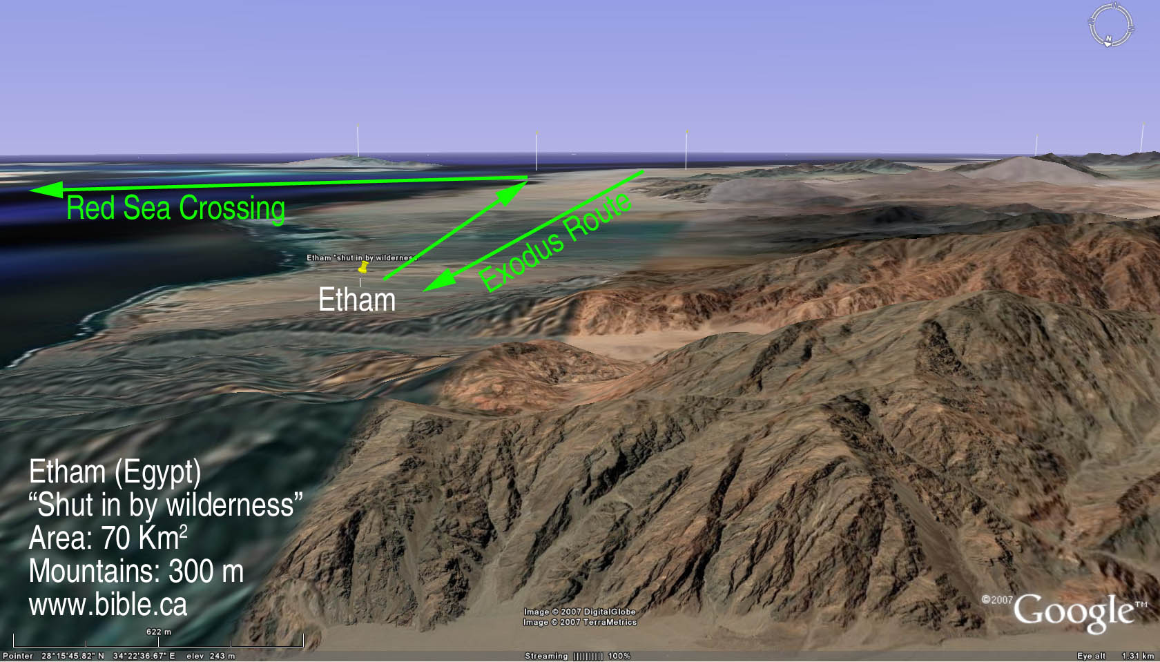
- The mountains that trapped Israel are 300 meters high.
- Etham, where they camped has an area of 70 sq. km.
- These mountains "shut them in" and are the end of the 200-mile coastal plain, "on the edge of the wilderness" (Ex 13:20).
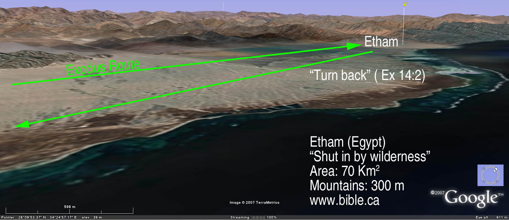
- God told them to "turn back" the direction they came and camp in front of the Migdol which was a military watch tower (Ex 14:2, Num 33:7).
- Scripture says that Israel came to a dead end at Etham, then God told them to turn back and retrace their steps and camp directly beside the "Migdol" in order for pharaoh to say, "Now the Lord spoke to Moses, saying, "Tell the sons of Israel to turn back and camp before Pi-hahiroth, between Migdol and the sea; you shall camp in front of Baal-zephon, opposite it, by the sea. "For Pharaoh will say of the sons of Israel, 'They are wandering aimlessly in the land; the wilderness has shut them in.' "Thus I will harden Pharaoh's heart, and he will chase after them; and I will be honored through Pharaoh and all his army, and the Egyptians will know that I am the Lord." And they did so." Exodus 14:1-4
- The location of Etham requires the exodus route to take Israel past the Migdol (military watchtower) AND the final camp of the Red Sea crossing, come to a dead end at Etham because the "wilderness to shut them in", then turn back and retrace their steps and camp beside the sea under the nose of the Egyptians watching in the Migdol.
- This key point is what disqualifies all other Red Sea crossing points except for the Straits of Tiran. No other proposed crossing point works.
- The Straits of Tiran fit perfectly... because it is really where Israel crossed!
- At Nuweiba Israel is not trapped because there is an easy route north along the coast to Elat. In fact, some actually map the route between their Mt. Sinai at Mt. Musa to Ezion Geber, to the Nuweiba beach, then north as a normal easy route.
- I have personally driven from Mt. Musa to Nuweiba to Elat and the route to get to Nuweiba is no more difficult than the route north to Elat.
- Of course, the route to Nuweiba and after crossing to Arabia is too difficult and contradicts the markers of the exodus route in several other aspects.
- The proposed Nuweiba exodus route has no backtrack at Etham, only a change of course 20 km before reaching Nuweiba.
- Then Nuweiba advocates cross to Arabia, pass through the middle of mountains south to near El Bad.
- Then they travel to the required second Red Sea camp and then BACKRACK to El bad then join the Tiran crossing route to Mt. Sinai.
- All this makes one wonder if the two routes join south of El Bad why God would not just have them cross at Tiran, being easier, shorter in distance and 9 days shorter in time.
- THE ETHAM DILEMMA:
|
|
The Etham dilemma is usually utterly ignored since all other proposed Red Sea crossings provides no block, stop, retrace and camp at the crossing point. The very idea that Israel was outside Egypt's control after crossing at the Bitter Lakes (the Hebrew's weekend fishing vacation spot while they lived in Goshen) or the major Egyptian seaport on the north shore of the Gulf of Suez (I would not rejoice after crossing, I would keep running) is unconscionable. At Nuweiba there is an easy escape along the coast north to Elat. In fact, the Straits of Tiran provide the only workable geography to solve the Etham dilemma. After crossing at Tiran into Saudi Arabia, they were truly "out of Egyptian control". Only then did thy rejoice in the wilderness of Shur, the historic homeland of Ishmael and Jethro of Midian. |
- The "Wilderness of Etham": There are a number of ways of viewing the wilderness of Etham:
- After crossing the Red Sea, they went three days into is the wilderness of Shur. Therefore, the Wilderness of Etham is identical to the Wilderness of Shur.
b. Etham may be derived from Egyptian word for wall/fortification. Hb. šûr = “wall” and Egyptian htm = “wall, fortress”. "wilderness of Etham Although identified as Shur in Exodus 15:22, this need not imply two versions. Etham is simply Egyptian for Hebrew Shur, both meaning “wall, fortification.” " (The JPS Torah Commentary: Numbers 33:8, 1999 AD)
c. Perhaps the Straits of Tiran were viewed as a "wall" from both sides. On either side there was no place to go but back or cross to the other side. It was a dead end on both sides!
- The "Wilderness of Etham" may not exist. It is not in original text of the Bible in the Septuagint. It is only found in one passage: Num 33:8. Etham is not in the LXX at Num 33:8. Instead, the Septuagint has the word, "they" which is spelled almost the same, with the vowels removed. This is a gloss that has crept into out Bibles. It may be a textual gloss: Etham is not found in the LXX in Number 33:8. The Hebrew has no vowels and "Etham" is almost identical to "them". Perhaps the Masoretes erred when they added the vowelling. Many commentators completely ignore it in Num 33:8.
e. It may simply mean there is a place called Etham on both sides of the Gulf of Aqaba at the straits of Tiran.
- Which if these two are correct is not that important. It simply means that there was a place called Etham before they crossed the Red Sea and a second place called the "Wilderness of Etham" after they crossed.
A. Bible texts:
1. "Now the Lord spoke to Moses, saying, "Tell the sons of Israel to turn back and camp before Pi-hahiroth, between Migdol and the sea; you shall camp in front of Baal-zephon, opposite it, by the sea. "For Pharaoh will say of the sons of Israel, 'They are wandering aimlessly in the land; the wilderness has shut them in.' "Thus I will harden Pharaoh's heart, and he will chase after them; and I will be honored through Pharaoh and all his army, and the Egyptians will know that I am the Lord." And they did so." Exodus 14:1-4
2. "Then they set out from Succoth and camped in Etham on the edge of the wilderness." Exodus 13:20
3. "They journeyed from Succoth and camped in Etham, which is on the edge of the wilderness. They journeyed from Etham and turned back to Pi-hahiroth, which faces Baal-zephon, and they camped before Migdol. They journeyed from before Hahiroth and passed through the midst of the sea into the wilderness; and they went three days' journey in the wilderness of Etham and camped at Marah." Numbers 33:6-8
B. Etham and Red Sea were the "distant edge" of the wilderness:
1. Immediately before the crossing of the Red Sea is "Etham, which is on the edge of the wilderness." Numbers 33:6. Traditional thinking interprets this as the starting edge of the wilderness on the west side of the Bitter Lakes before they entered what is traditionally called the Sinai Peninsula.
2. When you cross a wilderness there are always "two edges". The near edge at the start of the wilderness crossing and the far edge as you leave the wilderness.
3. The correct interpretation is that Etham was on the far and outer edge of the wilderness after they had traveled through it to reach the Red sea.
4. We know this is correct, because most people ignore the fact that the Bible says Israel crossed a wilderness before coming to the Red Sea. They leave Goshen, travel through the wilderness and after they have crossed this wilderness, they arrive at Etham and the Red Sea and cross it". (Exodus 13:18; Judges 11:16)
C. Travel Itinerary, distances and speeds from Goshen to Red Sea:
See also: Travel times, distances, days of the week
|
Itinerary from Goshen to Red Sea Crossing at Tiran |
||||
|
Bible texts |
Day # from Red Sea |
Weekday |
distance from last stop |
|
|
Goshen to Succoth |
Exodus 12:37; 13:20; Numbers 33:5-6 |
1-9 |
Thursday- Friday |
240 km |
|
Etham: 460 km. (Passes Red Sea Camp at 436 km then 24 km to Etham) |
Exodus 14:1-4: 13:20; Numbers 33:6-8 |
10-16 |
Saturday – Friday |
220 km |
|
Red Sea Camp: 484 km |
Exodus 14:1-4 |
17-24 |
Saturday-Saturday |
24 km |
|
Cross Red sea: 500 km |
Exodus 14:13-31 |
25 |
Sunday |
16 km |
|
|
|
|
Total |
500 km |
|
Calculating rates of travel from Goshen to Tiran |
|||||
|
Trip |
Distance |
Total days |
Camp days |
Travel days |
Daily rate of travel |
|
Goshen
to Red Sea (including Etham backtrack and Red Sea crossing) |
500 km |
24 |
7 |
17 |
29 km/day 18 miles/day |
|
Etham backtrack distance from the camp by the Red Sea at the crossing point to Etham and back again (24 km x 2) |
48 km |
- |
- |
- |
- |
|
Red Sea Crossing at Tiran (16 km included in Goshen to Red Sea 500 km) |
16 km |
1 |
- |
1 |
16 km/day 10 miles/day |
|
Red
Sea to Sinai |
200 km |
22 |
11 |
11 |
18 km/day 11 miles/day |
|
Goshen to Sinai (including Etham backtrack 44 km and Red Sea crossing 16 km) |
700 km |
47 |
18 |
29 |
24 km/day 14 miles/day |
|
On day 17 when Israel backtracks from Etham, a message from Pharaoh's military "Migdol" to Egypt by homing pigeon at 80 km/hour (average speed is 100 km/hour): "They are moving aimlessly and the wilderness at Etham has shut them in." |
400 km |
5 hours
4 hours |
- |
- |
80 km/hr. 48 miles/hr.
100 km/hr. 62 miles/hr. |
|
On day 18 Pharaoh's army begin pursued Israel with horses and 600 choice chariots (and other standard chariots for a total perhaps of 2000) from Egypt to where the angel stopped them. (Ex 14:6-9) |
400 km |
7 |
0 |
7 |
57 km/day 34 miles/day |
|
Herodotus (450 BC): Mediterranean to Gulf of Suez |
150 km |
4 |
- |
- |
38 km/day |
D. The positioning of the camp of Israel:
1. Exodus 14:2 :"Tell the sons of Israel to turn back and camp before Pi-hahiroth, between Migdol and the sea; you shall camp in front of Baal-zephon, opposite it, by the sea.
2. Numbers 33:7: They journeyed from Etham and turned back to Pi-hahiroth, which faces Baal-zephon, and they camped before Migdol.
3. Pi-hahiroth means a "mouth of water" in Hebrew. Notice that "Pi-hahiroth faces Baal-zephon" in Num 33:7. If you look at the "mouth" it indeed faces Baal-zephon!
|
Geographic reference |
Israelite Camp: Exodus 14:2,9 |
Israelite Camp: Num 33:7 |
|
Pi-hahiroth "mouth of water" |
before Pi-hahiroth |
turn back to Pi-hahiroth |
|
Migdol "watchtower" |
between Migdol and the sea |
camped before between Migdol |
|
Baal-zephon (idol Baal) |
camp in front of Baal-zephon, opposite it |
Pi-hahiroth faces Baal-zephon |
E. Photos:
|
Aerial view |
|
|
How the mountains of the wilderness "shut them in" Ex 14:2 The mountains are 300 meters high. |
|
|
Aerial view of the mountains that trapped Israel at Etham. |
|
|
Looking directly at the Mountain range from ground level. Etham has an area of 70 sq. km. |
|
|
Standing on the mountains that "shut them in". |
|
|
They turned back and camped under the nose of Pharaoh's watchmen in the Migdol who sent a message by pigeon in 5 hours back to Egypt. |
|
|
They waited 8 days for Pharaoh to arrive, then crossed the sea. |
|
F. How the traditional choice for Etham fails:
1. In the traditional exodus route, Etham would be somewhere past the actual Red Sea crossing point. It is important to remember that they went past the Migdol to Etham, then back tracked to camp at the Red Sea. For the Bitter lakes, such is impossible, for the Bitter lakes are so small, that anywhere past, would be on the other side of the Bitter lakes!
2. The Port of Suez crossing is also a disaster when you try to fit Etham into the route. If you go past the actual crossing point, you come to a huge open plain with nowhere to have the "wilderness shut them in".
3. Nuweiba is a total fail because Israel could just head north from the beach without being trapped. Some exodus routes that feature a Red Sea crossing at the Bitter Lakes and a Mt. Sinai at Mt. Musa actually route through the Nuweiba beach as a way to reach Elat and Ezion Geber. Some Nuweiba
By Steve Rudd: Contact the author for comments, input or corrections.