Debunked Exodus Routes: Red Sea, Mt. Sinai and Kadesh Barnea
Correct Exodus Route: Exodus Route home page
1. Red Sea crossing at Straits of Tiran
2. Mt. Sinai in Saudi Arabi, Jebel Lawz
3. Kadesh Barnea at Petra
|
|
|
||

Buy “Exodus Route Restored” from Amazon by Steven Rudd
Buy Discounted copy: Email Steven Rudd to order: Order discounted copy direct from author by email
|
In AD 2005, using the Bible only, Steven Rudd noticed 42 keys to decoding the Exodus Route that indicated the Red Sea crossing was at the Straits of Tiran, Mt. Sinai was in Saudi Arabia and Kadesh Barnea was at modern Petra.
ISBN: 9798619062717
As featured in Tim Mahoney’s Patterns of Evidence “The Red Sea Miracle”
|
|


Introduction:
A. Correct Exodus Route Locations:
1. CORRECT: Red Sea crossing at Straits of Tiran
2. CORRECT: Mt. Sinai in Saudi Arabia probably Mt. Lawz
3. CORRECT: Kadesh Barnea at Petra
B. Rejected and Debunked Exodus Route locations
- Debunked Red Sea Crossings:
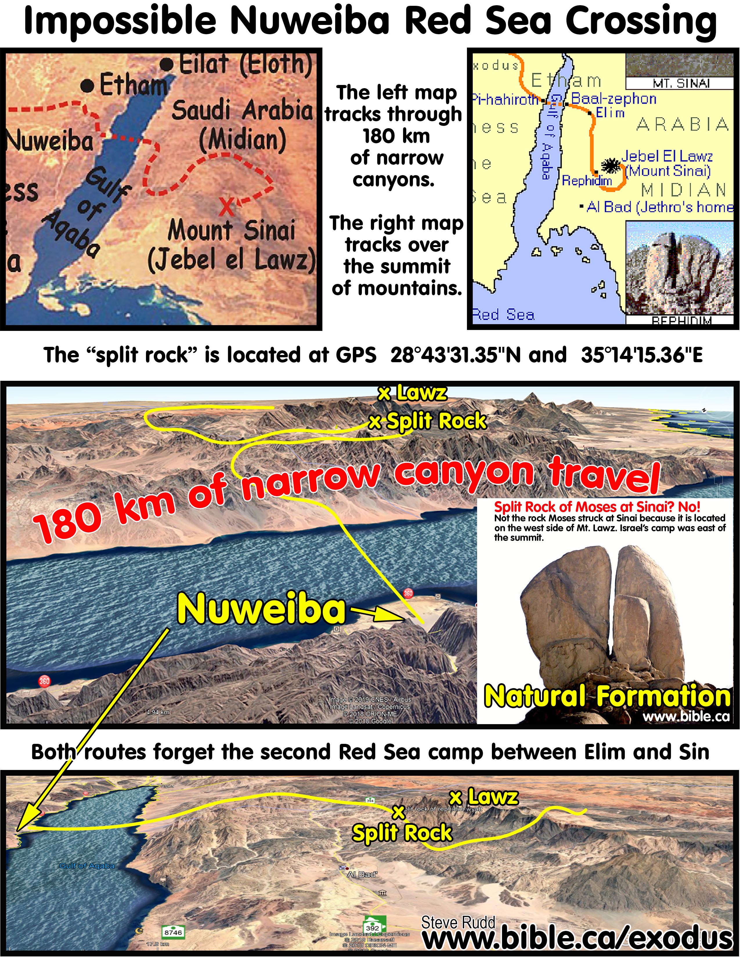
- REJECTED: Nuweiba Beach (Ron Wyatt, Lennart Mueller, Bob Cornuke, Glen Fritz)
- REJECTED: Menzaleh or Tanis Lake (Alan Gardiner, 1922; Carl Drews)
- REJECTED: Sirbonis Lake (M. J. Schleiden, 1858; Heinrich Brugsch, 1874)
- REJECTED: Port of Suez (Traditional)
- REJECTED: El-Ballah Lakes (James Hoffmeier, Bryant Wood, David Rohl)
- REJECTED: Timsah Lake (William Schlegel, Barry Beitzel)
- REJECTED: Bitter Lakes (Gordon Franz)
- REJECTED: Elat (Sir Colin Humphries)
- Debunked Mt. Sinai candidates:
- REJECTED: Mt. Musa at St. Catherine's monastery (Traditional, David Rohl, William Schlegel)
- REJECTED: Mt. Karkom (Emmanuel Anati)
- REJECTED: Mt. Khashm et-Tarif (Bryant Wood, William Schlegel alternate)
- REJECTED: Mt. Sin Bishar (Gordon Franz)
- Debunked Kadesh Barnea candidates:
- REJECTED: Ein el-Qudeirat (Woolley and Lawrence since 1916 AD)
- REJECTED: Central Judean Negev (Glen Fritz)
II. 41 Keys that decode the Exodus Route:
A. List of 41 Keys that decode the Exodus Route
1. The entire exodus was a miracle.
2. Exodus calendar: The 47-day journey from Goshen to Mt. Sinai: Ex 19:1.
3. God was in total control of the travel itinerary of the exodus route.
4. Southern route not west or north: Ex 13:17-18.
5. The “way of the Red Sea” is the road beside the Gulf of Suez to Tiran: Exodus 13:18.
6. Gulf of Aqaba is “yam suph” (Red Sea).
7. The Red Sea crossing was deep enough to clearly be a massive divine miracle.
8. The exodus population was 3.5 million not 5730 or 12,000 or 35,000.
9. Thutmoses III was the Pharaoh of the Exodus.
10. Gulf of Aqaba missing from “Dark Ages” maps.
11. Ballah and Timsah lakes were inside Goshen and cannot be the Red Sea crossing sites.
12. Long journey through the wilderness before reaching the Red Sea.
13. Etham and the Red Sea were further than 3 days from Goshen.
14. The Etham Dead End and Backtrack.
15. The dead end and was at Etham, not the final Red Sea camp.
17. Moses crossed the Red Sea on day 25 from Goshen: (Iyar 9)
18. Two miracles were involved in parting the Red Sea: Miraculous power and miraculous wind.
19. Wooden Chariots and their wheels float and contained no metal.
20. Marah is the closest Israel will come to Jethro at Midian (Al Bad).
21. Second Red Sea Camp.
22. Elim, the Wilderness of Sin and Mt. Sinai must be in a direct line-of-sight sequence: Ex 16:1
23. After crossing the Red Sea, the first major directional change in course was at Elim.
24. Elim and the 2nd Red Sea camp were close to each other.
25. The 2nd Red Sea camp is close to the Wilderness of Sin.
26. Israel arrived as a single group at the Wilderness of Sin on the same day: Ex 16:1.
27. The 8-day camp at the Wilderness of Sin to learn the Manna/Sabbath cycle.
28. Journeyed in small “stage” groups between Dophkah and Alush.
29. The 5-day camp at Rephidim.
30. Rephidim is on the east side of Mt. Horeb at the base of the mountain.
31. Find Ishmael, find Mt. Sinai: Gal 4:25.
32. Hagar’s two flights to Shur were south of not west of Hebron and Gerar.
33. The Hebrew camp was east of the summit of Mt. Sinai.
35. The Wadi el-Arish is the historic border between Egypt and Israel.
36. The southern border of Judah proves Kadesh Barnea is near or at Petra: Num 34:3-5; Josh 15:1-4.
37. Moses spent 38 continuous years at Kadesh Barnea.
38. Edom did not live in the Negev at the time of the Exodus.
39. The Negev of Judah was bounded by the Salt Sea, the Gulf of Aqaba and the Wadi El-Arish.
40. The Conquest began in 1406 BC and took 6 years.
41. The archaeological evidence and ancient literary sources for Mt. Sinai in Saudi Arabia.
B. Discussion of 41 Keys that decode the Exodus Route:
1. The entire exodus was a miracle:
a. Scripture says that Israel miraculously travelled day and night and therefore walked far greater daily distances than under normal human conditions: Ex 13:22; Neh 9:12; Num 14:14; Ps 105:39; Ps 78:14. The average human walking speed is 5 km per hour. Daily travel rates from Goshen to the Straits of Tiran were 29 km for each of the 17 travel days and 18 km for each of the 11 travel days from the Red Sea and Mt. Sinai. Without any miraculous assistance, 3 million Hebrews walking 5 km/h could easily travel 30 km in only 6 hours. That is 3 hours of walking in the morning and a 2-hour rest then 3 hours of walking in the afternoon.
b. God provided supernatural assistance while Israel walked long distances for long periods of time so that they did not get sore feet or sore muscles: Deut 8:4; Neh 9:21
c. God provided supernatural help while crossing the Red Sea so that nobody (young or old) tripped or stumbled: Isaiah 63:11-14; Ps 105:37
d. Their clothing and shoes did not tear, break or wear out for 40 years: Deut 29:5
e. God provided rain for water when needed in addition to the split rock at Mt. Horeb and Kadesh Barnea: Psalm 68:7-9; 105:41
f. God provided food for both man and beast: Israel took their flocks and herds with them. In addition to the 3 million Hebrews, were hundreds of thousands of flocks of sheep and herds of cattle: Exodus 10:9,26; 12:38; 34:3; Num 20:19. Both men and animal needed food. "And in their heart they put God to the test by asking food according to their desire. Then they spoke against God; They said, “Can God prepare a table in the wilderness? “Behold, He struck the rock so that waters gushed out, and streams were overflowing; Can He give bread also? Will He provide meat for His people?” (Psalm 78:18–20) When Israel complained about food, God rained quail on the ground 44 inches deep. God miraculously provided food for both man and animal. God provided quail and manna for food (Psalm 105:40).
g. The cloud by day protected them from direct sunlight and acted as a rain umbrella: Psalm 105:39; Isaiah 4:4-6
h. The cloud was continuous assurance of the presence of God to give them peace: Ex 13:22
2. Exodus calendar: The 47-day journey from Goshen to Mt. Sinai: Ex 19:1
a. Israel left Egypt on the 15th day of the first month (Num 33:3), arrived at the Red sea on day 17, waited 8 days for Pharaoh to arrive, crossed the Red Sea on day 25, entered the Wilderness of Sin on day 31 (Ex16:1), spent 8 days in the Wilderness of Sin in order to learn the Sabbath Manna cycle then arrived at Mt Sinai on day 47 which was the 1st day of the third month (Ex 19:1).
b. Goshen to Sinai took 47 days not 60 days: Ex 19:1. Moses spotlights God’s divine providence behind the exodus journey by noting the precise timing of Israel leaving Goshen on a full moon and arriving at Mt. Sinai on a full moon.
c. A 47-day journey is foundational to the prophetic messianic synchronism of both the Law of Moses in 1446 BC and the Law of Christ in AD 33 being revealed on the day of Pentecost fulfilling Isa 2:1-4 and Acts 2:1. In three different places Augustine not only calculated a 47 day journey, he highlighted the messianic prophetic synchronism that both Old and New laws were given on Pentecost. (Augustine Against Faustus 32.12; Januarius Letter 55; Sermon 272B) Just as there was fire on the summit of Mt. Sinai when the Law of Moses was given on Pentecost, so too there were “tongues of fire” on the heads of the twelve apostles on Pentecost when the Law of Christ was given. “The appearance of the glory of the Lord was like a consuming fire on the mountain top." (Exodus 24:17)
d. Moses received the Law during his 3rd ascension on the summit of Mt. Sinai: Ex 19:16-25; 20:1-26; Heb 12:18-29 but Fritz has this event occurring after the day of Pentecost. Scripture and ancient sources show that the Law of Moses and the Law of Christ were both given on the day of Pentecost: Isa 2:2-5; Acts 2:1-4. Fritz dismisses this critical messianic prophetic connection between both Old and New Testament Laws being revealed on Pentecost. Fritz comments, “The biblical timing of Pentecost 50 days after Passover is not being disputed here. What is disputable is the late rabbinic tradition that Pentecost also commemorated "the giving of the law” (Exodus Mysteries, Glen Fritz, p450, 2019 AD). Fritz paints a false portrait that the earliest Jewish literary sources support his 61-day journey with no connection with Moses receiving the Law on Pentecost. He sweeps away any association of the Law being revealed on Pentecost as a “late rabbinic tradition”. This is a shocking and unscholarly misrepresentation of the earliest Jewish literary sources because the opposite is true. There is unanimous agreement of all Jewish and Christian literary sources from the earliest in 170 BC down to AD 500 that the journey from Goshen to Sinai was 47 days and the Law of Moses was given on the day of Pentecost.
e. Both the Babylonian Talmud (Pesahim 68A) and the Midrash (Tanḥuma C) state that Moses received the Torah on Pentecost which proves a 47-day journey. Seder Olam Rabbah which dates to AD 160 specifically says that the law was given on Sivan 6 which is day 52, a perfect fit for a 47-day journey. (SO 5:31) Finally, the Book of Jubilees which dates to 170 years before Christ says in the opening verse that Moses received the two stone tablets of the Ten Commandments on Sivan 16 or day 62 after leaving Goshen. This corresponds to Moses’ 6th ascension up Mt. Sinai when he spent 40 days (Ex 24:12-18). All this proves the exodus route from Goshen to Sinai was 47 days. This has devastating consequences for advocates of the Nuweiba Beach Red Sea crossing and specifically Glen Fritz who cannot make Mt. Sinai earlier than day 64 because his route is 888 km long.
3. God was in total control of the travel itinerary of the exodus route:
a. God chose the route, not Moses: Ex 13:21; Neh 9:12; Num 14:14,19; Ps 78:14
b. Moses did not know he was heading to Mt. Sinai when he left Goshen and he was not choosing the route of travel. This is important because many suggest Moses headed directly towards Elat as though he knew the final destination was the Midian area.
c. The shortest route to Midian from Egypt is crossing the Straits of Tiran. When Moses fled Pharaoh, he may have crossed the Red Sea by hiring a boat to reach Jethro at Midian on the far shore. Glen Fritz makes the false assumption that Moses fled from Pharaoh to Midian by passing through Elat then south.
d. Even if the Straits of Tiran was the route Moses took to flee Pharaoh, Moses still had no idea where he was going. Moses would not have assumed in advance that God would part the Red Sea in order to reach Mt. Sinai. Once across, Moses might also have wrongly assumed he was heading for Midian to visit Jethro.
4. Southern route not west or north: Ex 13:17-18
a. The route from Goshen to the Red Sea did not head north or west towards the coastal route to Philistia, but south to the Red Sea: Ex 13:17-18.
b. Any Red Sea crossing site that heads north from Goshen directly contradicts Ex 13:17-18 and must be rejected. These rejected sites include Menzaleh/Tanis Lake (Carl Drews) and Sirbonis Lake.
c. The Glen Fritz Nuweiba route to Elat is the same basic westerly direction for the first 75 km as the forbidden “way of the Philistines” except it runs a bit southerly.
5. The “way of the Red Sea” is the road beside the Gulf of Suez to Tiran: Exodus 13:18
a. The Tiran route travels the same “way to the Red Sea” road as the traditional route to Mt. Musa. The Tiran and traditional routes follow the identical path for the first 280 km from Goshen. While appealing to the consensus view that the way to the Red Sea lead to the Gulf of Suez, is no assurance of being right, dismissing the consensus view, needs to be based upon a solid reason. There are no known ancient literary sources that call the road from Egypt to Elat the “road to the Red Sea”.
b. Both the Gulf of Aqaba and Suez are called the Red Sea in scripture. There were numerous roads called the “way to the Red Sea” in the Bible, depending on your starting destination. Roadways were named after their final destination and geography.
i. In 2080 BC, the “way to Shur” was the road Hagar took from Hebron, south towards Ezion Geber (Elat) that ultimately led do Midian (Gen 16:7). Then in 2066 BC, Hagar fled from Gerar to the Wilderness of Beersheba heading towards Shur (Gen 21:21).
ii. In 1446 BC, the way of the Philistines, was the coastal trade route from Tel el-Dab’a up the coastline of Canaan to where the Philistines lived. This was known also as the “way of Horus”. Exodus 13:17
iii. In 1446 BC, the “way to the Red Sea” was the coastal road from Egypt that led to the Gulf of Suez and then hugged the eastern banks to Tiran: Exodus 13:18
iv. In 1444 BC, the “way to the Red Sea” was the road in the Arabah valley from Kadesh Barnea at Petra towards Ezion Geber (Elat): Numbers 14:25
v. In 1407 BC, the “way to the Red Sea” was the road in the Arabah valley from Kadesh Barnea at Petra towards Ezion Geber (Elat): Numbers 21:4; Deut 1:40; 2:1.
c. The most logical route for the “way to the Red Sea” is due south towards the Gulf of Suez. God had forbidden Moses to go due west on the “way of the Philistines”.
d. The Nuweiba route travels the road that leads to the Gulf of Aqaba and Ezion Geber which runs south west.
6. Gulf of Aqaba is “yam suph” (Red Sea): Studying the meaning of “yam suph” (Red Sea, sea of reeds) is irrelevant since the Gulf of Aqaba is called the “Red Sea” in five different scriptures: Ex 23:31; Num 21:4; Deut 2:1; Judges 11:16; 1 Kings 9:26. The second Red Sea camp after Elim was on the Arabian Gulf which was called “the red Sea” (yam suph, Numbers 33:10). A huge amount of time and energy has been wasted by engaging in almost endless etymological gymnastics in defining the meaning of YAM SUPH. The Gulf of Suez, Gulf of Aqaba and the Arabian Gulfs are all called the “YAM SUPH”. Those who say the Greek Septuagint mistranslated “yam suph” as Red Sea are at variance with the 70 translators who were the top Hebrew scholars from Jerusalem in the world in 282 BC. The Greek Septuagint was the standard synagogue “pulpit Bible” and only Old Testament used by the first century church. Those who say the common Hebrew word for the colour red used in the book of Exodus is a different word than “suph” in “yam suph”, are in a dogfight with the Holy Spirit who twice used the ordinary word for the colour “red” in the Greek New Testament in “Red Sea” (Acts 7:36; Heb 11:29). Let us forever ban “sea of reeds” from our vernacular in discussing the Exodus route unless one begins by demonstrating that scripture calls all three saltwater ocean gulfs the Sea of Reeds.
7. The Red Sea crossing was deep enough to clearly be a massive divine miracle: At the Straits of Tiran the walls of water were up to 300 meters on both sides. The Red Sea crossing was a miraculous demonstration of God’s divine power: Exodus 13:3; Deut 26:8; 7:8. Shallow freshwater “sea of reeds” lakes are wrong because they minimize the miraculous through naturalistic explanations. These rejected Red Sea crossing sites include Menzaleh or Tanis Lake (Carl Drews), Sirbonis Lake and Elat (Sir Colin Humphries). These must be rejected out of hand because they deny the miraculous. In 5554 BC when God created the world in 6 literal 24-hour days, he was taking his time. Scripture indicates it is very deep water like the Gulf of Aqaba, not shallow water a few meters deep:
a. “The deeps cover them; They went down into the depths like a stone." (Exodus 15:5)
b. “At the blast of Your nostrils the waters were piled up, The flowing waters stood up like a heap; The deeps were congealed in the heart of the sea." (Exodus 15:8)
c. “You blew with Your wind, the sea covered them; They sank like lead in the mighty waters." (Exodus 15:10)
d. “You divided the sea before them, So they passed through the midst of the sea on dry ground; And their pursuers You hurled into the depths, Like a stone into raging waters." (Nehemiah 9:11)
e. "The waters saw You, O God; The waters saw You, they were in anguish; The deeps also trembled." (Psalm 77:16)
f. "Your way was in the sea And Your paths in the mighty waters, And Your footprints may not be known." (Psalm 77:19)
g. "Thus He rebuked the Red Sea and it dried up, And He led them through the deeps, as through the wilderness." (Psalm 106:9)
h. "Thus says the Lord, Who makes a way through the sea And a path through the mighty waters," (Isaiah 43:16)
i. "Was it not You who dried up the sea, The waters of the great deep; Who made the depths of the sea a pathway For the redeemed to cross over?" (Isaiah 51:10)
j. "Who led them through the depths? Like the horse in the wilderness, they did not stumble; As the cattle which go down into the valley." (Isaiah 63:13)
8. Three million Hebrews: The exodus population was 3.5 million not 5730 or 12,000 or 35,000. The Hebrew word “eleph” can only mean the number 1000 in the population census passages. The popular etymological fiction that “eleph” means “clans” in the population census trashes the inspiration of scripture and is refuted by Numbers 3:39–51, Exodus 38:24-29 and 1 Corinthians 10:8.
9. Thutmoses III was the Pharaoh of the Exodus:
a. The Exodus was about God humbling the proud and powerful. The Pharaoh of the Exodus had to be one of the greatest and most powerful Pharaoh’s who ever lived: Ex 9:16. Thutmoses III was the Pharaoh of the Exodus because he was one of the greatest in Egyptian history whereas his son Amenhotep II, was small, weak, insignificant and unaccomplished in contrast. Both Thutmoses III and Herod the Great stand out in history as megalomaniac builders.
b. Death of Pharaoh’s firstborn son: Thutmoses III was the Pharaoh of the Exodus and his eldest son Amenemhat died in the 10th plague. Amenhotep II was not the firstborn son of Thutmose III who succeeded his father in 1431 BC.
c. Pharaoh did not drown in the Red Sea: The Pharaoh of the Exodus did not die in the Red Sea, but the army sank into very deep water: Exodus 15:4-5,10; Ps 136:15
10. Gulf of Aqaba missing from “Dark Ages” maps: The Dark Ages that lasted for over 1000 years was triggered by the Muslim conquest in 642 BC. During this “dark” 1000 years of information loss, Bible cartographers were unaware of the existence of the Gulf of Aqaba. This omission created defective Bible maps which prevented Bible students from considering a Red Sea crossing at the Straits of Tiran on the Gulf of Aqaba. All historic maps produced during the dark ages down to about AD 1750 chose Red Sea crossing locations near Egypt, and Mt. Musa was the only choice for Mt. Sinai. The “enlightenment” restored the Gulf of Aqaba to Bible maps. Bible students today do not suffer from this historic handicap of the missing Gulf of Aqaba and are now free to consider Mt. Sinai in Saudi Arabia.
11. Ballah and Timsah lakes were inside Goshen and
cannot be the Red Sea crossing sites:
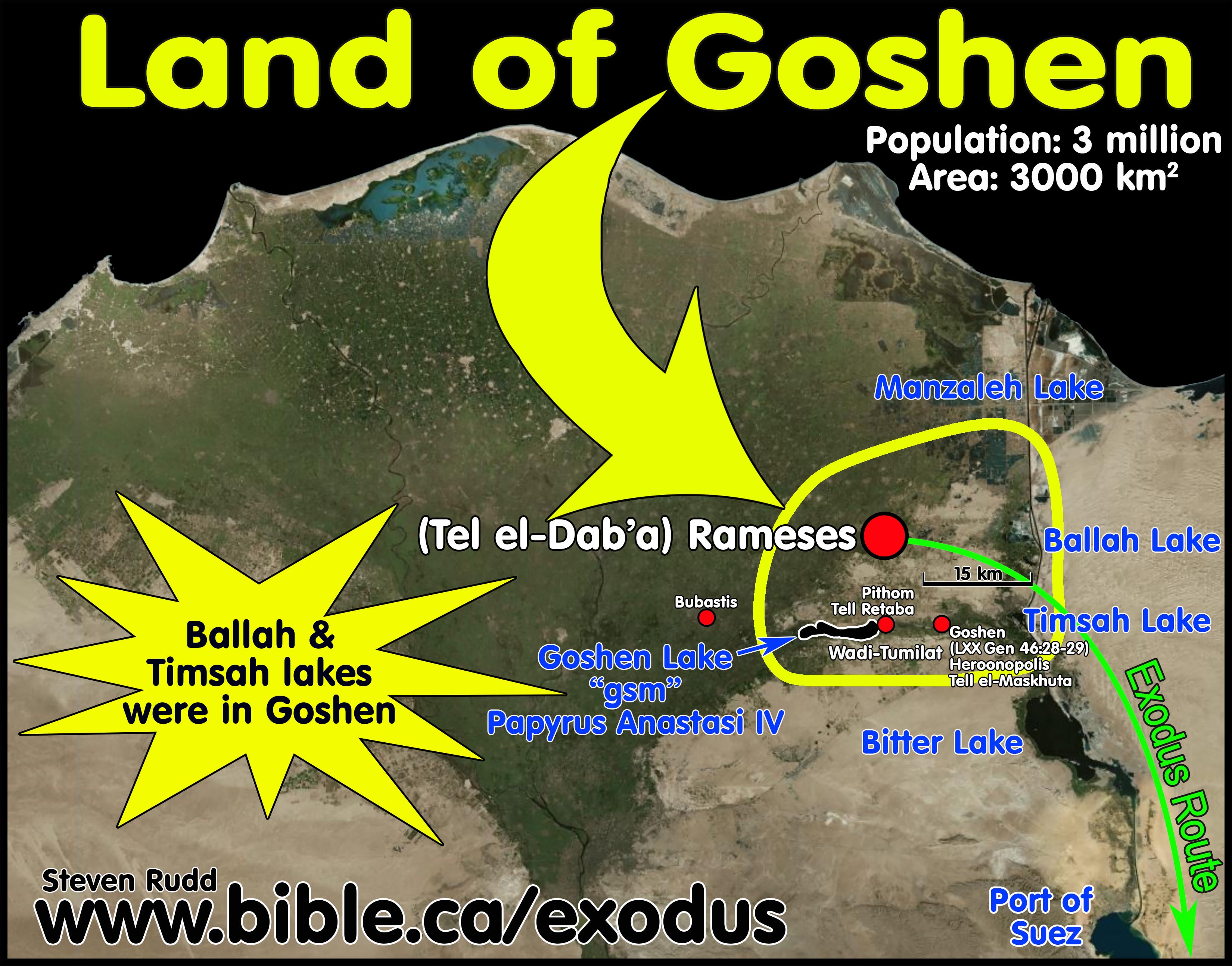
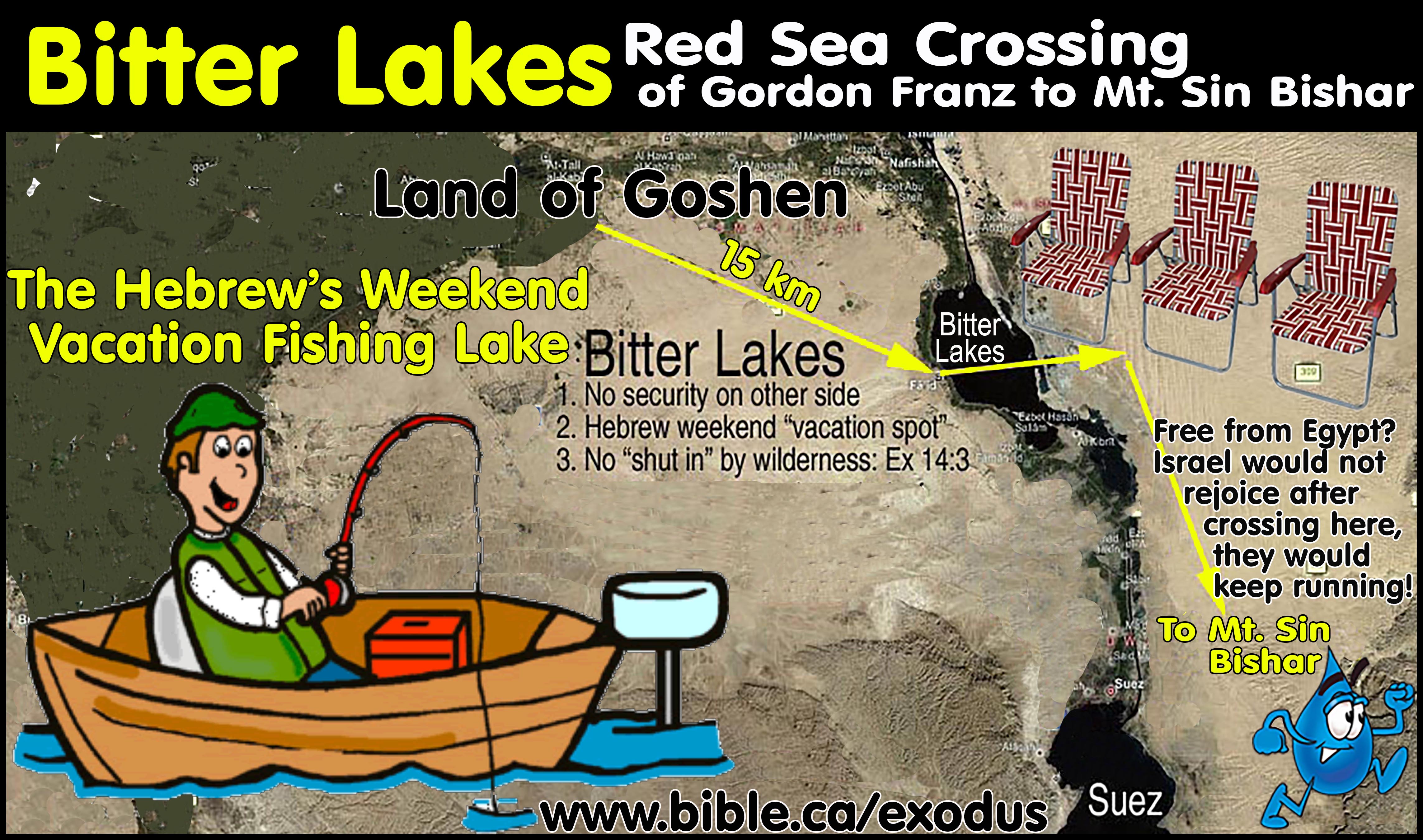
a. Ballah lake and Timsah lake cannot be the Red Sea crossing site because they are inside the land Goshen. These two freshwater lakes would be an important water supply for the 3 million Hebrews who would occupy the entire area from Tel el-Dab’a to the Suez Canal. The lakes were a major food supply of fish for the Hebrew like the Sea of Galilee at the time of Jesus. It is likely therefore, that the entire shoreline was surrounded and occupied by Hebrews. While Ballah lake and Timsah lake are 40 km east of Tel el-Dab’a, both lakes were entirely inside the land of Goshen. Even the Bitter lakes would be used regularly by the Hebrews as a commercial fishing center being only 15 km south of the land of Goshen.
b. Lake Goshen in the Wadi Tumilat, the city of Goshen (Heroonpolis = Tell el-Maskhuta) and Pithom (Tell el-Retaba) were all inside the land of Goshen. The Septuagint changes Goshen in the Masoretic text to Heroonpolis in Genesis 46:28-29. In 282 BC the top Jewish scholars translated the Hebrew into Greek in Alexandria and centered Goshen at the Wadi Tumilat. The City of Pithom is Tell el-Retaba: located at in the Wadi Tumilat at the eastern shore of lake Goshen.
c. This has devastating consequences for those who propose a Red Sea crossing at either the Ballah lake or Timsah lake. Imagine the entire lake is surround by Hebrew tents and suddenly Moses brings them to the western shore and parts the sea. On the other side, several of the Hebrews likely ran inside their houses to grab a few more things for the trip to Mt. Sinai! It is also impossible for the Hebrews to be trapped at any of these freshwater lakes.
d. If Goshen extended to the Suez Canal, then there was no wilderness for Israel to travel through before reaching the Red Sea at Ballah or Timsah Lake.
e. Pithom and Heroonpolis was only 15 km and 7 km respectively from lake Timsah which several propose as the “Sea of Reeds” Moses crossed. This is too close to be a three days journey outside the land of Goshen. Many look at the 40 km Rameses is from lake Timsah and feel this is a good distance for a three day journey through the wilderness. Since Rameses was the western portion of Goshen and the Wadi Tumilat was the center of Goshen, it makes the Red Sea crossings at either Ballah lake or Timsah lakes impossible because they were part of Goshen.
12. Long journey through the wilderness before reaching the Red Sea: Israel went through a wilderness to get to the Red Sea. The
Hebrew occupation in Wadi Tumilat which included Goshen Lake,
Pithom at Tell el-Retaba, and Heroonpolis at Tell el-Maskhuta is less than 10
km from the western shores of lake Timsah. This means there was not three days
of travel through the wilderness for Israel before reaching the Red Sea at Ballah
or Timsah Lake. The Red Sea is located at the distant edge of the wilderness,
far from Goshen, not the beginning edge of a wilderness near Goshen: Ex
13:18-20; Num 33:6; Judges 11:16. Philo said around AD 50: “having
accomplished together a long and desolate journey
through the wilderness, destitute of any beaten road, at last arrived at
the sea which is called the Red Sea.” (Philo, On the Life of Moses 2:247) We can prove this because Moses travelled through a wilderness to
reach “Etham on the edge of the wilderness”. Those who advocate Red Sea
crossing locations that are close to Egypt, ignore that Etham and the Red Sea
crossing are on the distant edge of the Sinai peninsula wilderness as opposed
to the beginning edge of the Sinai peninsula wilderness near the Suez canal. Only Gulf of Aqaba candidate sites correctly have Israel travelling
through a large wilderness, at the distant end of which is Etham and the Red
Sea crossing. The Red Sea must be far enough away from Goshen to prevent the
Hebrews from simply walking home in a day. They must also be far enough from
Goshen to justify their bitter complaints about being in the wilderness: Exodus
14:11-12. The Bitter Lakes were so close to Goshen (15 km), they were likely a
popular vacation and weekend fishing resort for the Hebrews when they got time
off from brick making.
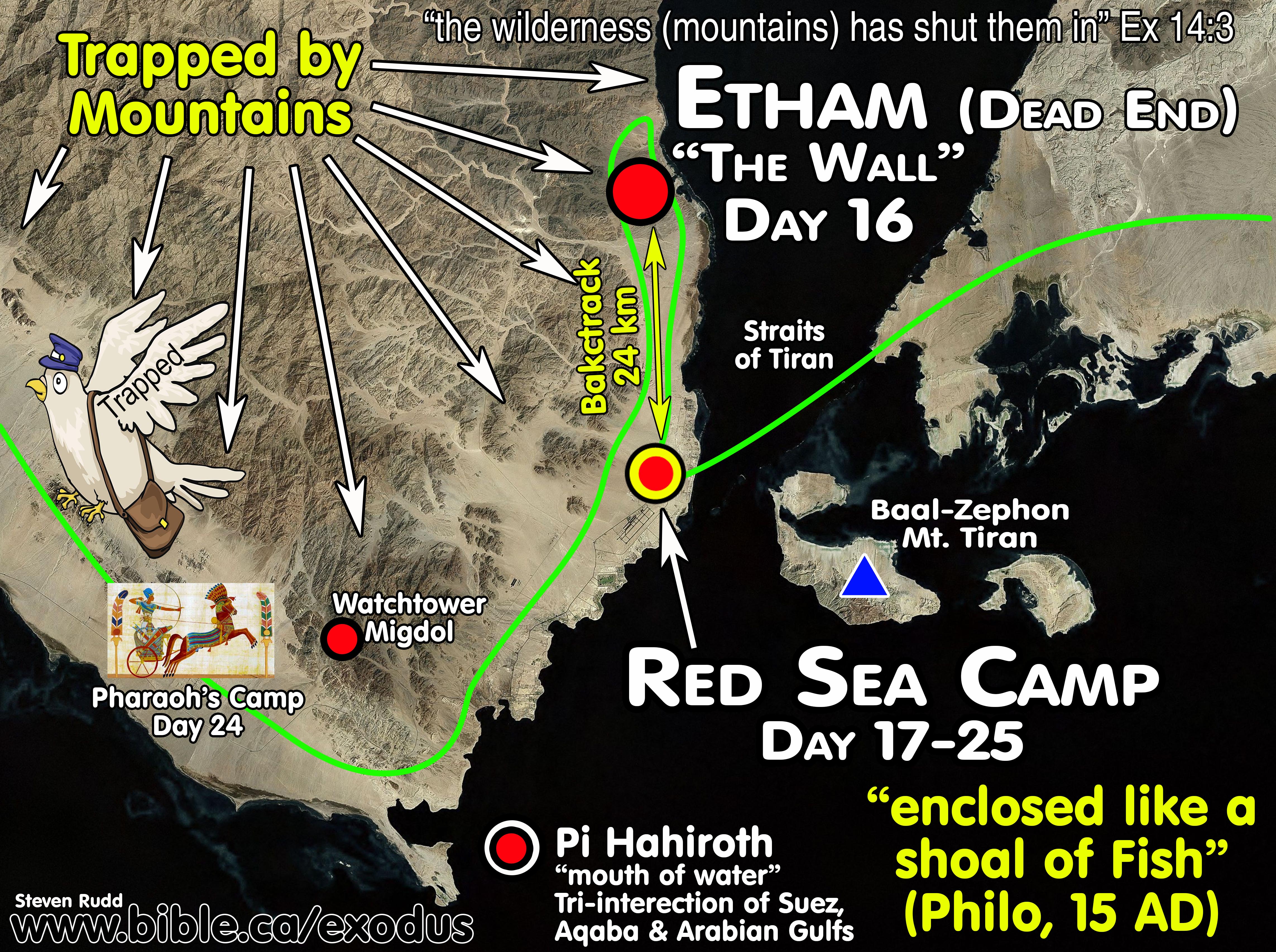
13. Etham and the Red Sea were further than 3 days from Goshen:
a. The Red Sea crossing had to be at least 3 days from Goshen proving a crossing on the Gulf of Aqaba is the only possibility: Exodus 5:3. There were three stops between Goshen and the Red Sea which means it is a minimum of a three day journey. Lake Ballah and Timsah were in Goshen. The Bitter Lakes were 15 km from Goshen and the Port of Suez contradict Exodus 5:3 because they are much less than three days away from Tel el-Dab’a. The three days of Ex 5:3 and the three stops between Goshen and the Red Sea do not give us any useful information about how far the Red Sea crossing or Mt. Sinai are because we know they crossed the Red Sea on Day 25 (Ex 16:1) and the total trip to Sinai was 47 days (Ex 19:1).
b. After Israel crossed the Red Sea it must be geographically isolated from Egypt in order to prevent Pharaoh’s army easily perusing Israel a second time. This geographic separate from Egypt after crossing should trigger Israel to rejoice and continued their trip to Mt. Sinai in peace without any chance of further threat. All near-Egypt crossing sites are too close to Egypt to be out of danger after crossing. Israel would not have rejoiced after crossing the Red Sea at the Bitter or Timsah Lakes, they would keep running in fear! The north Gulf of Suez crossing exits directly beside the major seaport and Egyptian army base. The Tiran crossing is a perfect fit being separated by 16 kms of ocean and at least a 30-day journey for the Egyptian army to reach them by travelling over the north tip of the Gulf of Aqaba and down to the Wilderness of Shur.
c. The Nuweiba route contradicts the Bible because Etham is not on the edge of anything and does not fit being located “at the edge of the Wilderness”. Fritz’s Etham is in the middle of the Sinai Peninsula, at no place of any significance, 27 km from the Gulf of Aqaba and Elat. In an odd coincidence, Fritz locates Etham at Mt. Khashm et-Tarif, which is Bryant Wood’s misplaced location for Mt. Sinai. Fritz has Moses march right by Khashm et-Tarif, then make a right turn towards the Nuweiba beach.
d. The location of Etham in the Tiran route is a perfect fit being on the distant edge of the Wilderness one stop from the final Red Sea camp while Israel unknowingly waited for Pharaoh to arrive.
14. The Etham Dead End and Backtrack: Ex 14:2-3. Israel passed by
the Red Sea camp to Etham and hit a dead end then backtracked, retracing their
steps to the final Red Sea camp where they waited for Pharaoh. The Tiran
crossing is a perfect fit. The Hebrew word used for “turn back” is the same one
used when the waters of the Red Sea “returned” and drowned the Egyptians. It is
also the common word for “repentance” in Isaiah. The Nuweiba route fails
because at Etham it merely changes course by making a right-hand turn to reach
the Gulf of Aqaba at the Nuweiba beach four days away.
a. The Hebrew word for “turn back” is “šûb” in Ex 14:2 and Num 33:7 “Tell the sons of Israel to turn back [šûb] and camp before Pi-hahiroth”
b. “šûb” is the primary verb for “turn back”, “return” and “Repent”.
c. It was used when the “waters returned to its normal state and covered the Egyptians” Ex 14:27-28
d. “šûb” is the word behind repent in Isa 6:10, which is quoted by Jesus in Matthew 13:15. “Render the hearts of this people insensitive, Their ears dull, And their eyes dim, Otherwise they might see with their eyes, Hear with their ears, Understand with their hearts, And return [šûb] and be healed.” (Isaiah 6:10) The meaning of repent/backtrack/turn back in salvation is that sinners are walking towards Satan and they are to turn back 180 degrees and start walking the opposite direction to God.
15. The dead end and was at Etham, not the final Red Sea camp: Moses came to the Straits of Tiran and unknowingly passed directly over the final Red Sea camp and continued another 24 km to the dead end at Etham where the mountains come down to the sea. It was at the dead end that God told Moses to turn back and travel 24 km back to where he has passed the day before and camp waiting for Pharaoh to arrive. God was using the Hebrews as bait when they backtracked from the dead end at Etham. Advocates of the Nuweiba crossing have no dead end or backtrack at Etham but they do have a dead end at the Nuweiba beach. A careful reading of the Bible text shows that the dead end was specifically at Etham and the final Red Sea camp was a reverse course to a previous point they had been the day before.
16. Trapped at the Red Sea: Israel knew they were trapped because they had gone as far as they could to Etham, then were forced to return because of the mountains that steeply drop to the shoreline. Only at the Straits of Tiran was Israel trapped with no escape when they camped before crossing the Red Sea: Ex 14:2-3. Their only escape was back up the eastern shore of the Gulf of Suez towards Egypt. Every other proposed Red Sea crossing location, including Nuweiba cannot trap the Hebrews at the Red Sea. The Egyptians would not cross through the Bitter lakes, they would simply march two hours to the other side and wait in lawn chairs with a cold drink for the Hebrews to exit the “sea of reeds”. It is impossible to be trapped at the Nuweiba beach because there are at least 5 escape routes. Professional cartographer William Schlegel, in his Satellite Bible Atlas (AD 2013), used the Nuweiba beach as a transit walk-through between traditional Mt. Sinai (Mt. Musa) to Ezion Geber. Schlegel, who lived in Israel for many years, saw the western coastline north of Nuweiba as an easy route between Mt. Musa to Elat. As Pharaoh’s army approached Nuweiba the Egyptians would need to split up into several groups to block these exit routes to trap Israel. Scripture speaks of a single angel blocking the Egyptian army and the Nuweiba beach would require up to 5 angels to block all the escape routes. Josephus is generally of little help regarding the exodus route. His numbers for the size of the Egyptian army are reasonable.
a. “Another reason for this was that God had commanded him to bring the people to Mount Sinai, that there they might offer him sacrifices. Now when the Egyptians had overtaken the Hebrews, they prepared to fight them, and by their multitude they drove them into a narrow place; for the number that pursued after them was six hundred chariots, with fifty thousand horsemen, and two hundred thousand footmen, all armed. They also seized on the passages by which they imagined the Hebrews might fly, shutting them up between inaccessible precipices and the sea; for there was [on each side] a [ridge of] mountains that terminated at the sea, which were impassable by reason of their roughness, and obstructed their flight; wherefore they were pressed upon the Hebrews with their army, where [the ridges of] the mountains were closed with the sea; which army they placed at the chops of the mountains, that so they might deprive them of any passage into the plain.” (Josephus Antiquities 2.324, 70 AD)
b. Note: The translators added the words in brackets [on each side] and are not what Josephus said.
c. Taken at face value, Josephus’ description of mountains trapping Israel at the Red Sea is a perfect fit for Tiran and contradicts all near Egypt crossing points like the Bitter lakes etc. because there are no mountains to trap anyone in the Nile Delta area within 100 km. The North Suez crossing has mountains but there is no way to be trapped against the sea.
d. Josephus says the Egyptian army split up and blocked all the escape passages through the mountain canyons. There are several problems with Josephus here. First, with his usually vague descriptions such a detailed specific is questionable. Josephus never says where the Red Sea crossing or Mt. Sinai are geographically located, not even a hint. For him to be this specific regarding the Egyptian army blocking escape canyons begs credibility. Second, if the army split up then God would need more than one protection angel to guard their approach. Third, several of the canyon escape routes at Nuweiba are only accessible from geographically remote areas. If Josephus is describing Nuweiba, Pharaoh would need to send troops from the south and north, in addition to blockading several canyon escapes routes. This is quite different from the Bible record that a single army approaches and is held at bay by a single angel, and the topography of the Straits of Tiran is a perfect fit.
17. Moses crossed the Red Sea on day 25 from Goshen: (Iyar 9)
a. Israel travelled three days in the Wilderness of Shur (days 26-28) and arrived at Marah. They travelled one day and arrived at Elim on day 29. They travelled another day and arrived at 2nd Red Sea camp on day 30. Finally, on 6th day after crossing the Red Sea, the entire 3 million Hebrews arrived at the Wilderness of Sin on day 31 which was Iyar 15 (Ex 16:1). Scripture tells us they travelled “3 days” from the Red Sea to Marah and that Moses arrived on day 31 at the Wilderness of Sin with only two stops between.
b. This is a total of six travel days after crossing the Red Sea to reach the Wilderness of Sin on day 31 from Goshen.
c. Counting six travel days back from day 31 (Iyar 15) we can be certain the Red Sea crossing was on day 25 (Iyar 9).
d. A Red Sea crossing at the Straits of Tiran on day 25 is a perfect fit for the timing and topography. No other location is a perfect fit for a day 25 Red Sea crossing.
18. Two miracles were involved in parting the Red Sea. First, God’s miraculous power to keep the waters
parted before and during the crossing. Second,
the wind miracle to rapidly dry the sea floor.
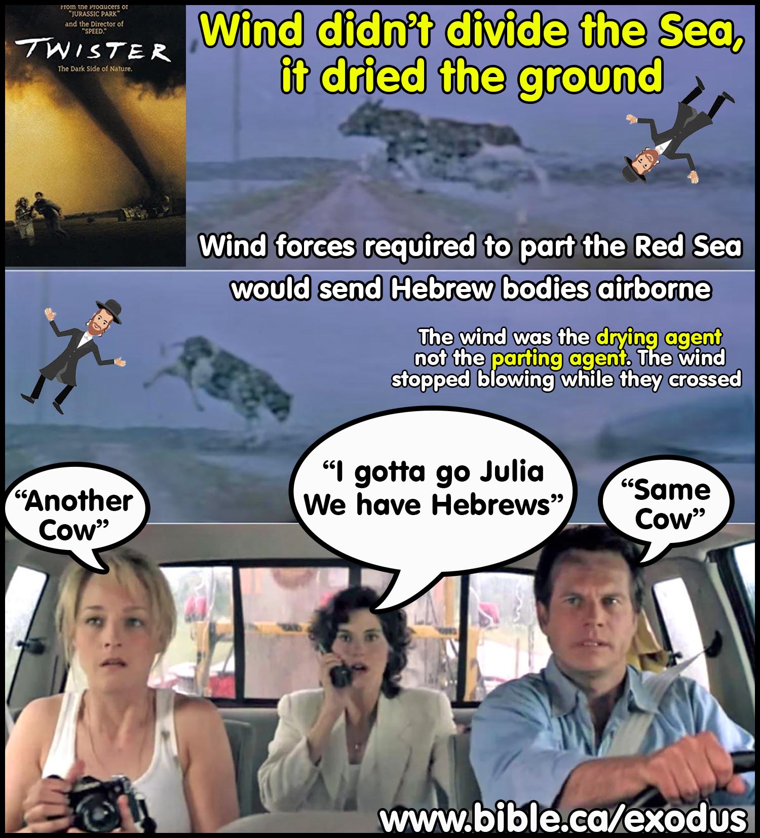
a. The waters parted almost instantly through God’s unspeakable power, but it took over night for the wind to dry the seafloor. Once the ground was dry the wind stopped blowing and Israel crossed the Red Sea in quiet tranquility. Once the lack of wind lured the Egyptians into the Red Sea, God once again created a wind storm, withdrew the supernatural forces holding the walls of water up and the Egyptians sank 1300 meters to the bottom of the Red Sea on either side of the Straits of Tiran. This refutes the naturalistic wind theory of Carl Drews in his Red Sea crossing at Menzaleh/Tanis Lake.
b. Wind was how God dried the ground, not how he kept the waters parted. Wind speeds greatly exceeding a tornado would be required to keep water displaced and would send human bodies airborne.
19.
Wooden Chariots and their wheels float, and contained
no metal:

a. Movies often depict the cinematic fiction of chariot wheels slowly sinking to the bottom immediately after the waters drowned the Egyptian army. Since chariots were made of wood they would simply float away. Chariots in the 18th Egyptian dynasty were not overlaid with metals except for ceremonial constructions never taken into war. In the exodus Egyptian army, the only possible chariot that contained any gold overlay, would have been of Thutmoses III, but he never entered the Red Sea with his chariot. War chariots were made from 100% hardwood Tamarisk wood and chariot wheels contained no metal. Even the axle pins were wooden as witnessed in the chariot of King Tut. Tamarisk is a dense wood that takes months to become waterlogged and sink to the bottom. This means that chariot wheels would immediately float to the surface and drift hundreds of kilometers before washing to shore or sinking to the bottom far away from the Red Sea crossing site. 18th dynasty chariots were made of Tamarisk wood and floated quite well. Tamarisk is also called, salt-cedar, and tamarix. The chariots from King Tut’s tombs seen in museums are made entirely of wood and rawhide and contained no metal. Later period chariots used a few small metal pins to hold wooden parts together but even these chariots floated on top of the water and did not sink.
b. When 250-meter-high walls of water at the Red Sea at Tiran “backtracked” upon the Egyptian army on dry ground, the forces were likely sufficient to splinter the chariots into toothpicks and all the wheels would float to the surface. The leather harnesses that tethered the chariot to the horses would likely break and the entire chariot would float to the surface with intact or in pieces since it is 100% wood. If the chariot remained connected to the horse after drowning, the buoyancy of the chariot might keep the dead horse at the surface. If both chariot and horse sank to the bottom, the body of the dead horse would float to the surface through bacterial decay in about two weeks.
c.
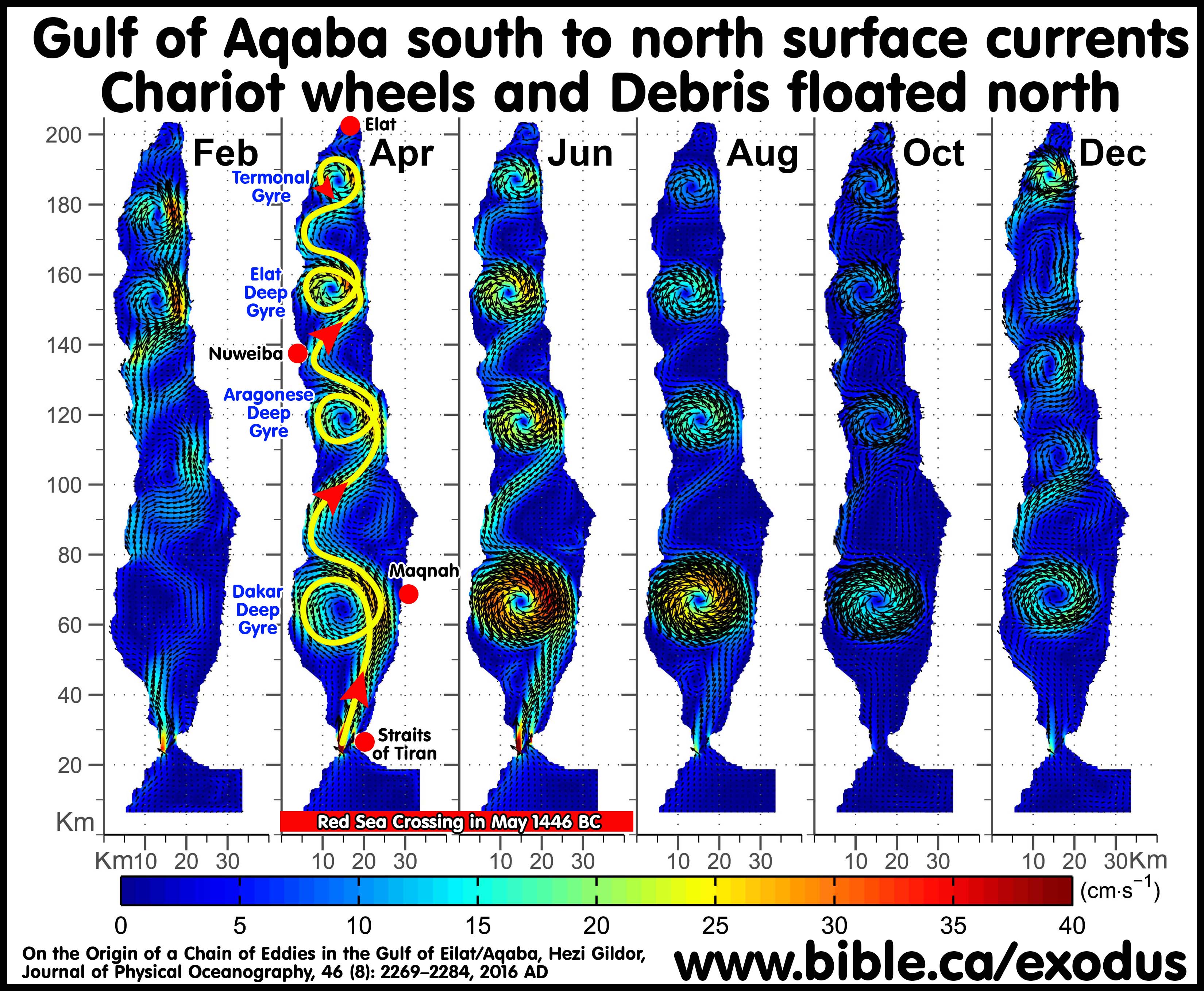
Gulf of Aqaba surface water currents move from south to north and are
strongest in the spring when Israel crossed the Red Sea. Warmer surface water
down to a depth of 70 meters, enters the Gulf of Aqaba at the Straits of Tiran
and moves north through a series of large counter-clockwise cyclonic gyres
(whirlpools) until it reaches Elat. As the northbound current reaches Elat, the
surface water cools and falls below 70 meters depth, where it joins a colder
underwater reverse current from 70-260 meters from the north to the south until
it exits the Gulf through the Straits of Tiran into the Arabian Gulf (Red Sea).
The surface current travelling north runs contrary to the prevailing wind
coming from the north. Glen Fritz wrongly suggested that the prevailing north
wind would cause floating debris at Nuweiba to drift south to the eastern
shoreline near Maqnah. Fritz suggests a straight-line wind-driven drift of
floating debris from Nuweiba to Maqnah that not only runs opposite to that
current, but independent of both the Aragonese Deep gyre and Dakar Deep gyre.
Fritz misrepresents the surface currents of the Gulf of Aqaba as one large
counterclockwise gyre. (see: Exodus Mysteries, Glen Fritz, p389, 2019 AD)
Studies have documented the surface current runs south to north in a single
direction until it is returned in deeper waters back into the Arabia Gulf. Like
a rip tide, the surface water flows north but the deeper water flows south. In
fact, the south to north current would eventually land the debris at the north
tip of the Gulf of Aqaba. This essentially refutes Glen Fritz’s speculation
that the Hebrews salvaged floating debris from Pharaoh’s army at Maqnah, which
he suggests as the second Red Sea camp. Current direction not wind direction
determines the movement of floating debris in the Gulf of Aqaba. Scuba diving
for remnants of Pharaoh’s 100% wooden chariot wheels and axles in the shallow
waters off the Nuweiba Beech is absurd given they would float and drift 100
kilometers north towards Elat in the surface currents. These northbound ocean
currents down to 70 meters were obvious in the Red
Sea Miracle II movie as a source of
difficulty for the divers. Eric Lembcke retells the story from around AD 2000,
when Rory Kaye ran out of air at 95 feet below the surface while looking for
chariot wheels off the Nuweiba beach with Ron Wyatt. Using a metal detector to
find 3400-year-old metal bronze parts embedded in coral and showing museum
displays of bronze axle caps is puzzling since 18th dynasty chariots were
constructed 100% of wood. The object they saw remains on the sea floor. Lembcke
confirms the currents were strong at the dive site. “Well we popped to the surface and my first reaction was, “Ron we got a
wheel, and I am not moving from this spot”. And Ron said, “Well you may not be
moving but the current is moving you fella”, and eh, and sure enough we were
drifting.” (Red Sea Miracle II, Eric Lembcke. Movie minute 1:53,
2020 AD)
i.
“Specifically, when the exchange flow is maximal
during April–August, the water entering the gulf [of Aqaba] becomes warmer as
it flows northward. Clearly the northward flow
at the surface cannot be driven by the atmosphere during that period.
From September to March, despite considerable cooling, the exchange flux is
minimal. Additionally, the transfer of mass from the surface to deeper layers,
as occurs in inverse estuarine circulation, takes place only during late
winter. During the rest of the year the surface layer
is flooded by the Red Sea water influx, but does not feed the subsurface
counterflow. Thus our simulated findings suggest that
within several months after the winter mixing conditions, the upper ∼150 m in the entire gulf [of Aqaba] is replaced with northern
Red Sea surface water.” (The general circulation of the Gulf of Aqaba revisited:
The interplay between the exchange flow through the Straits of Tiran and
surface fluxes, E. Biton H. Gildor, 1.10, 2011 AD)
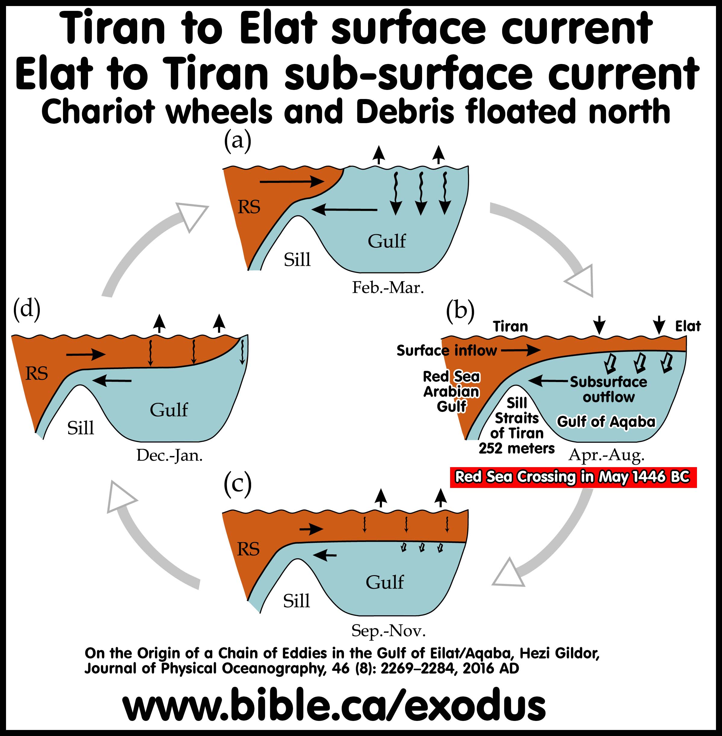
ii. “The circulation in the northern Red Sea and water exchange with the Gulf of Aqaba through the Strait of Tiran studied in the previous section showed a cyclonic gyre in the upper 215 m depth in the northern and a two layer water exchange through the Strait of Tiran. Inflow occurred in the upper 70 m, and outflow below 70 m down to the sill depth at about ~260 m.” (The general circulation and water masses characteristics in the Gulf of Aqaba and northern Red Sea, Riyad Manasreh, Marine Science Reports, No. 50, p62, 2002 AD)
iii. “Figure 3.2 shows the percent frequency of wind speed, which was 69.1% for wind speeds below 6 ms-1. This indicates that the wind blowing over Aqaba was relatively calm. The frequency of the wind direction from NNE to NNW was 92.2%.” (ibid. p22)
iv. “The current pattern during summer could be separated into three main layers, one from 20-60 m water column with northward current, second, a transition layer around 60 m depth, and third, from 60-80 m with southward current.” (ibid. p93)
v. “The general circulation of the gulf consists of relatively warm and fresh Red Sea surface water that enters from the south through the straits as a surface layer and flows northward, whereas the relatively cold and saline water of the gulf exits as the bottom layer of the exchange flow at the straits (21.5°C; 40.7 psu). The horizontal circulation is characterized by a chain of eddies adjacent to the main axis of the gulf, as previously shown by current measurements performed along the basin (Manasrah et al. 2004) as well as by numerical models (Berman et al. 2000; Biton and Gildor 2011b).” (On the Origin of a Chain of Eddies in the Gulf of Eilat/Aqaba, Hezi Gildor, Journal of Physical Oceanography, 46 (8): 2269–2284, 2016 AD)
d. The dense grain of hardwood slows down water logging. If they had any pitch coating (buoyancy neutral) that would slow down waterlogging even more. The waterlogged chariot wheel eventually sank far from the original location after months of drifting. Looking in the shallow waters of Nuweiba for chariot wheels is misguided.
e. Wood in water decays rapidly unless it is in a deep-water, cold, oxygen-depleted environment. The Gulf of Aqaba has several deep zones up to 1450 meters beside the Straits of Tiran. It is very unlikely that floating chariot wheels would become water-logged and sink in that location. Even if chariot wheels did sink in one of these “deeps” it would be buried under several meters of sediment after 3400 years. It is also absurd to suggest that shallow water coral formations photographed today, which vaguely look like a chariot wheel, had originally formed around the wooden chariot wheel which has long since decayed leaving a coral outline. Coral is a living animal that constantly changes shape over time with growth rates of 2-10 cm per year. Coral formations today will look quite different even 10 years in the future.
f. Both wheels and the connecting axle of a chariot were 100% made of wood and contained no metal parts at the time of the exodus. Unicorn Internet Archaeologists (UIA) who show pictures of coral formations in shallow water as proof of the Nuweiba Red Sea crossing must be ignored as fake news. None of these coral formations were ever brought to the surface. In the few short years since these coral formations were photographed, they have changed and are now broken up by natural processes so that they no longer look the way they originally did. The underwater photos of random coral formations used by these UIA’s are no more scientific than photographing clouds that look like chariot wheels. Using this fake evidence of chariot wheel shaped coral formations at the Nuweiba beach brings well deserved ridicule and scorn from the professional world upon Christians in general and is a disservice to the cause of Jesus Christ.
g. Sources:
i. “The Egyptian chariots were of light and simple construction, the material employed being wood, as is proved by sculptures representing the manufacture of chariots. The axle was set far back, and the bottom of the car, which rested on this and on the pole, was sometimes formed of a frame interlaced with a network of thongs or ropes.” (Dictionary of the Bible, James Hastings, Chariot)
ii. “Pictorial evidence from numerous reliefs plus several actual chariots from Egyptian tombs present a reasonably clear picture of how these war machines were made. In contrast to wheeled wagons used earlier and heavier chariots used later in parts of the ancient Near East, most chariots during this period were light vehicles built to carry two men. They were made mostly of bent hardwood and leather, with a few metal parts and wrappings of birch bark to repel moisture. … The Egyptians made their chariots from elm and tamarisk wood.” (Warfare in the Old Testament, Boyd Seevers, p129, 2013 AD)
iii. “Professor Yigael Yadin maintains that during the earlier part of the 18th Dynasty, the Egyptian chariot was "exactly like the Canaanite chariot" both were constructed of light flexible wood, with leather straps wrapped around the wood to strengthen it, and both utilized wheels with four spokes. In Yadin's eyes the four-spoked wheel is diagnostic for dating purposes; it is restricted to the early period of the 18th Dynasty. It remained in vogue, he says, until the reign of Thutmose IV, when "the Egyptian chariot begins to shake off its Canaanite influence and undergo considerable change." Yadin believes that the eight-spoked wheel, which is seen on the body of Thutmose IV's chariot, was an experiment by the Egyptian wheelwrights, who, when it proved unsuccessful, settled thereafter for the six-spoked wheel. In short, "So widespread and meticulous is the delineation of the number of wheel spokes on chariots depicted on Egyptian monuments that they can be used as a criterion for determining whether the monument is earlier or later than 1400 B.C. … A chariot scene from the tomb of Ken-Amun (dated to the reign of Amenhotep II) shows a partially obliterated chariot. Four-spoked wheels are invariably depicted with the spokes in a 12, 6, 3, and 9 o'clock position, but in this scene the two visible spokes point toward 12 and 4 o'clock; this indicates a six-spoked wheel." (Observations on the Evolving Chariot Wheel in the 18th Dynasty, James K. Hoffmeier, Journal of the American Research Center in Egypt, Vol. 13, p43, 1976 AD)
iv. “According to the evidence presented here, the six-spoked wheel is regularly portrayed in the chariots used by monarchs after Thutmose IV, the sole exception being the talatat scene from the Amarna period mentioned above. However, contrary to Yadin's position, the six-spoked wheel is found before 1400 B.C. But he is basically correct in stating that the six-spoked wheel is consistently shown on chariots after 1400 B.C. Yadin's explanation for the shift in the number of wheel spokes is hardly convincing. The Egyptians were certainly jingoistic, but it is stretching the point to believe that they would alter the number of wheel spokes merely to "shake off Canaanite influences," and thereby assert their nationalistic identity. They were eminently practical, and we must seek a practical reason for the change. The six-spoked wheel from the reign of Amenhotep II suggests that the shift must have begun even earlier. Thutmose III, Amenhotep II’s predecessor, launched at least 17 military campaigns into Syria-Palestine; one might surmise that in these circumstances the Egyptian chariot would undergo certain changes in order to achieve maximum performance. Unfortunately we have no battle scenes with chariots in action until the time of Tutankhamun. Before this, chariots are limited to hunting, domestic, and procession scenes.” (Observations on the Evolving Chariot Wheel in the 18th Dynasty, James K. Hoffmeier, Journal of the American Research Center in Egypt, Vol. 13, p44, 1976 AD)
v. “In our publication of 1989 we explained that the clamped-on metal tyres must have been used on disk wheels, such as are seen on the terracotta model from Susa and the fragmentary stone relief from Telloh. Disk wheels were the usual type of wheel in the Near East before the turn of the millennium b.c. For comparison, the cross-bar wheel—which represents an attempt disk wheel by combining a diametric bar, through which the axle passes, with lighter between it and the felloe—is first attested in the later third millennium. The much lighter wheels begin to appear in the early second millennium.” (Metal wheel tyres from the Ancient Near East and central Asia, J. H. Crouwel, British Institute for the Study of Iraq, Vol. 74, p91, 2012 AD)
vi. “Chariots are made of a frame of bent wood covered with leather. … The car was approximately hip-high and fully open at the rear, which made it easy to jump into quickly. The car was wide enough to hold two people standing side by side: one from Tutankhamun’s tomb was 1.02 meters wide by 0.44 meter deep. The axle was made of ash and in one example measures 2.3 meters in length. … The flooring is a leather thong mesh. The pole, usually of elm, was heat-bent and about 2.89 meters long. The wheels had felloes (outer rims) of ash, spokes of evergreen oak, and spoke lashings of birch bark. The earlier chariots had wheels with four spokes; later chariots had sixspoke wheels. Thutmose IV is depicted in a chariot with six-spoke wheels in battle with Asiatics, who are using chariots with four-spoke wheels. … Chariot wheels, felloes, and spokes were made from heat-treated wood. To make a spoke, single pieces of wood were bent at 90 degrees (for 4-spoke) or 60 degrees (sixspoke) and glued back to back. Wet rawhide was bound around them at the nave and then lashed with birch bark for waterproofing. Tires were of leather. Egyptian chariots were lightweight, one modern replica weighing 34 kilograms.” (Historical Dictionary of Ancient Egyptian Warfare, Robert G. Morkot, p63, 2003 AD)
vii. See also: Chariots and Related Equipment from the Tomb of Tutankhamun, M. A Littauer, p92-94,102, 1985 AD
viii. See also: Wheeled Vehicles and Ridden Animals in the Ancient Near East, M. A. Littauer, J. H. Crouwel, p81, 1979 AD
h. Conclusion: 18th dynasty chariots were made from 100% wood and floated. Two Tamarisk chariot wheels attached to their axle floated quite well. It is impossible to predict where nonbuoyant objects would sink because we have no information on how the two walls of water collapsed upon the Egyptian army. At the Straits of Tiran, nonbuoyant objects could be in both the Hume Deep and the Tiran Deep on either side of the Red Sea crossing track. Some drift materials would travel all the way to north Elat. Other drift materials would be washed ashore to the north of Tiran anywhere in the Gulf or sink at random distances after becoming waterlogged. Myths of chariot wheels found at Nuweiba are the Piltdown man of the Exodus route, except this time, Christians look ridiculous when the real science comes to light.
20. Marah is the closest Israel will come to Jethro at Midian (Al Bad):
a. The first time Jethro joins Moses was at Rephidim, which was one stop before arriving at Mt. Sinai.
b. Glen Fritz has Israel cross the Red Sea at Nuweiba then camp at Al Bad (Midian) as his Elim for three days.
c. If the actual exodus route passed directly through Midian, the hometown of Moses and Jethro, there would have been some notation by Moses.
d. Most obvious is that if Israel camped up to three days at Midian, Moses would not have called the location Elim! He would have called it Midian in the Numbers 33 itinerary list.
21. Second Red Sea Camp: Five days after crossing the Red Sea,
Israel camped at the Red Sea a second time while on route to Mt Sinai. Only a
Red Sea crossing at the Straits of Tiran provide a sensible, logical, and
workable second Red Sea camp on day 5 after crossing the Red Sea, and day 30
from Goshen. This is one day before Israel reached the Wilderness of Sin on day
31 from leaving Goshen (Ex 16:1).
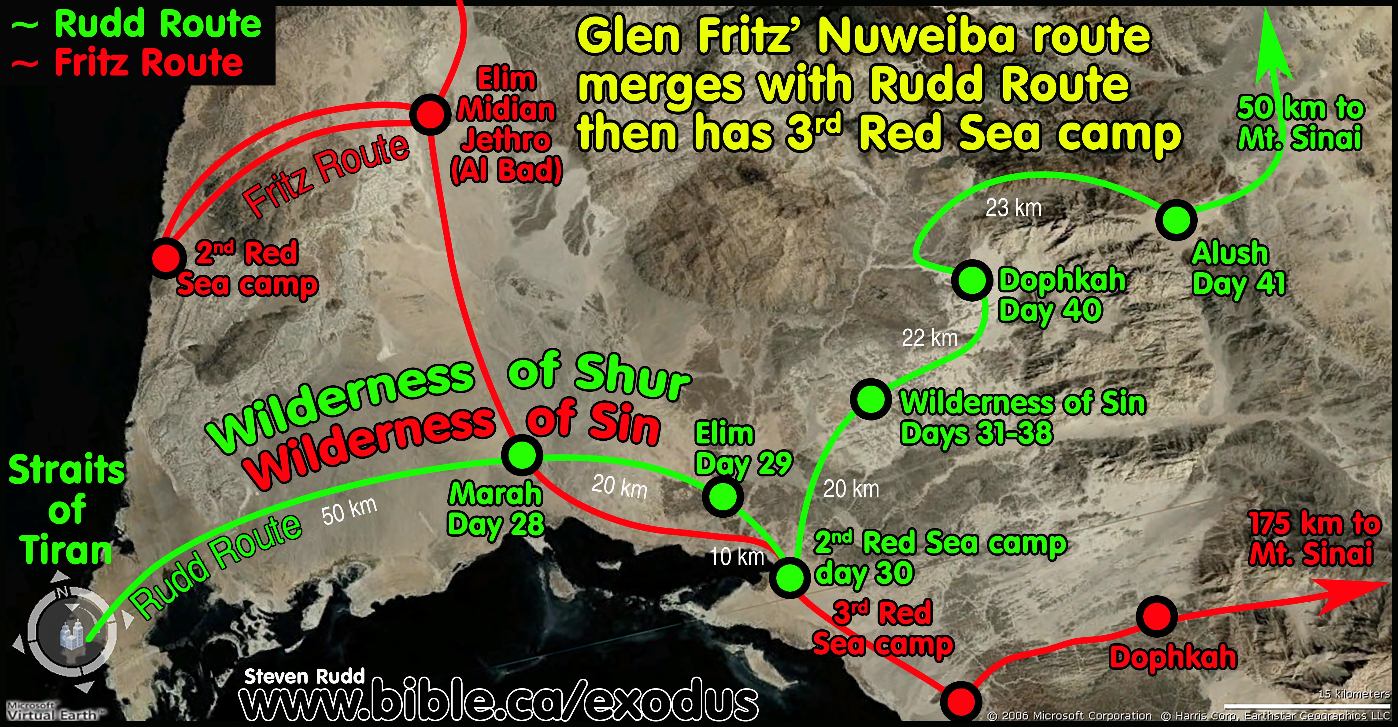
a. Glen Fritz’s Nuweiba southern route: A Nuweiba Red Sea crossing that takes a southern route around the mountain range to Mt. Lawz must immediately travel inland due east, then south to El Bad, then west, back to the Gulf of Aqaba for the second Red Sea camp. Then the route backtracks by retracing the route east to El Bad, then south to enter the Wilderness of Sin. This is time consuming, illogical, unworkable, and bizarre. Fritz also cannot afford the two extra days to reach the Wilderness of Sin by day 31, so he splits the Hebrews into two travel groups. The Main group bypasses the 2nd Red Sea camp altogether and heads strait to the Wilderness of Sin from Elim. The second travel group navigates one day from Elim through 32 km of canyons to reach the 2nd Red Sea camp at Maqnah then backtracks another day through the same 32 km of canyons back to Elim. Then they travel one day to the Wilderness of Sin arriving two days after the first group. The Nuweiba and Tiran routes intersect and merge at Fritz’s location for the Wilderness of Sin south of Al Bad and the Tiran location for Marah. FAIL
b.
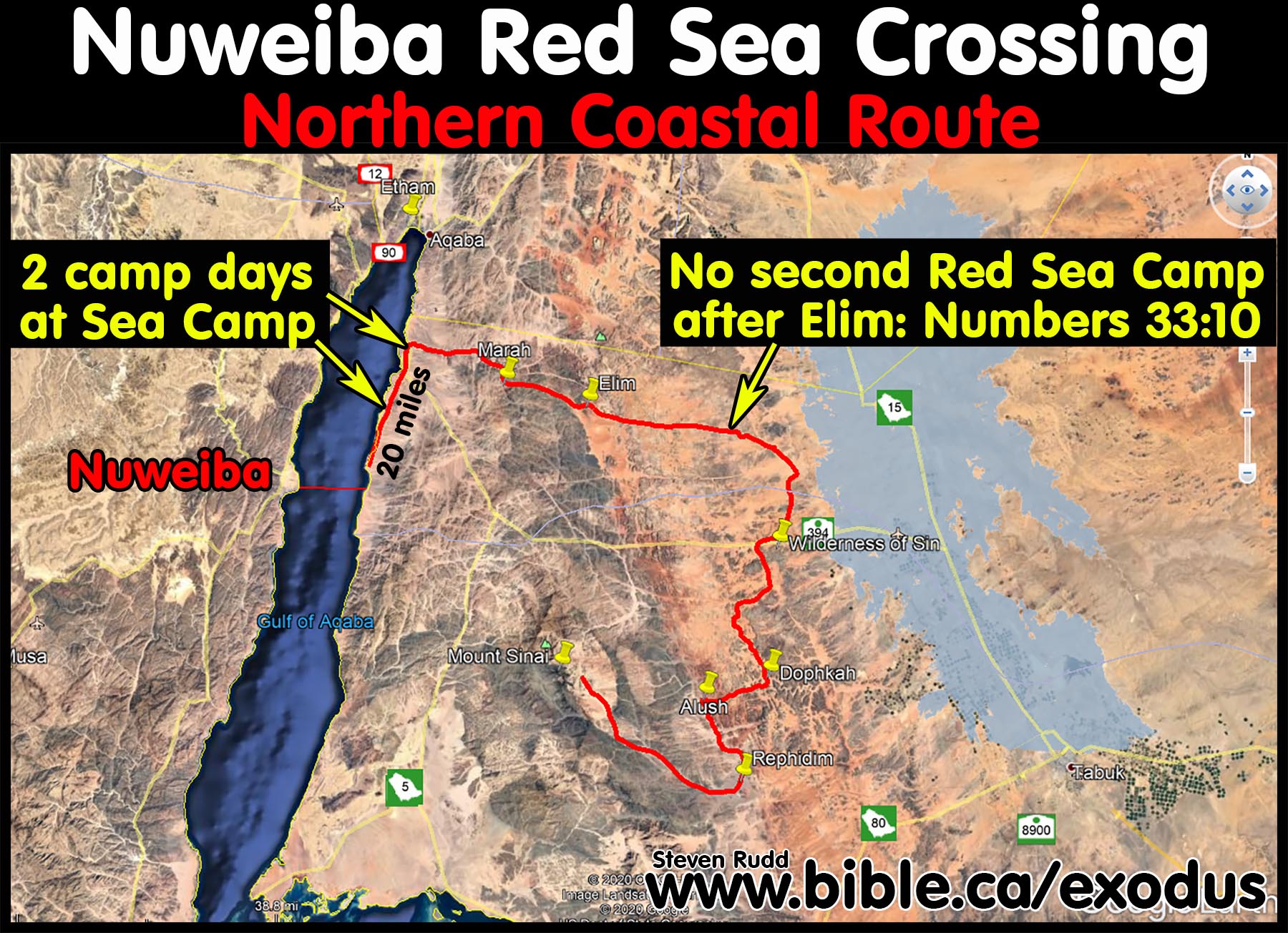
Nate Loper’s Nuweiba northern route: Nate Loper’s Nuweiba Red Sea
crossing takes a northern coastal route around the mountain range to Mt.
Lawz. After crossing at Nuweiba, he has Israel camp two nights in a row on the
Red Sea then turns east to reach Mariah on the third day. Elim is the next stop
after Mariah and it is impossible to facilitate a second Red Sea camp after
Elim and before the Wilderness of Sin, as the Bible requires in Num 33:10. Nate
Loper like many, ignores the second Red Sea camp altogether to make his route
work. FAIL The alternate northern
interior route follows the same track as Glen Fritz’s southern route except
once in the interior, it turns north at the same spot Fritz’s route turns south
to Al Bad. The problem with the northern interior route is that it requires
travelling 15 miles inland through narrow canyons only to head 15 miles back to
the Red Sea through narrow canyons, coming out 20 miles north of where they
crossed over from Nuweiba. While this satisfies Num 33:10 to provide a second
Red Sea camp, it becomes unworkable because it makes no sense to go 30 miles
inland through canyons, only to come out to the same place you could have
simply marched due north over much easier terrain after crossing the Red Sea. FAIL While both the northern interior of Loper,
and the southern interior route of Fritz do have a second Red Sea Camp, both
require illogical tracks to reach the sea. The northern interior route of Loper
is actually superior to the southern interior route of Fritz because everybody
passes through Elim, the second Red Sea camp to the Wilderness of Sin in one
large group sequentially, whereas Fritz’s route must break the Hebrews into two
travel groups, two days apart. FAIL The
Tiran route is a perfect fit in all aspects.
c.
Ron Wyatt Nuweiba route: Unicorn Internet Archaeologists like Ron
Wyatt, Larry Williams, Bob Cornuke, David Fasold, Howard Blum, Larry Williams,
Lennart Möller, Jim Caldwell, Penny Caldwell and Ryan Mauro rarely produce any
exodus route maps. The two examples below are commonly recycled all over the
internet. Their “comic book” looking maps both visit the “Split Rock” of
Rephidim, the last stop before reaching Mt. Sinai, which means Israel travelled
70 km to reach Rephidim in 21 days, then another 110 km to reach Mt. Sinai in 1
day. FAIL One map traverses directly over
the summit of high mountains between Rephidim and Mt. Sinai to reach Sinai in 1
day. Neither map has a second Red Sea camp. FAIL
22. Elim,
the Wilderness of Sin and Mt. Sinai must be in a direct line-of-sight sequence:
Ex 16:1
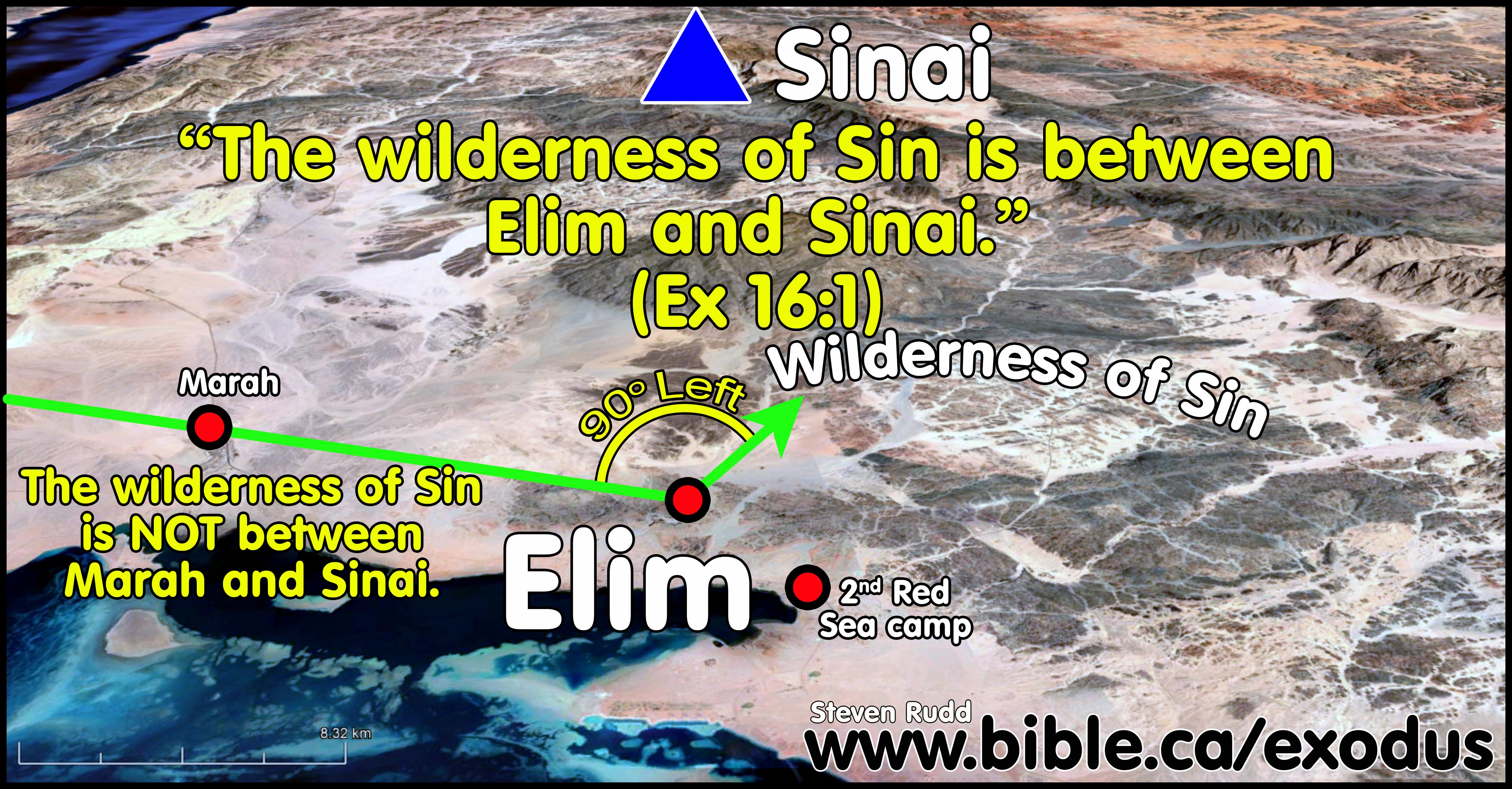
a. If you are on the ground standing at Elim and look towards Mt. Sinai, the Wilderness of Sin is between them. There is a linear and sequential geographic order in a line of site with Elim, Wilderness of Sin, Mt. Sinai.
b. Elim as a major oasis at Ain Ounah, was a significant and known location because it was used as a reference marker to locate "the Wilderness of Sin which is between Elim and Sinai". Ex 16:1
c. This sequential order is an important marker most people ignore in the Exodus Route by positioning Elim closer to Mt. Sinai than the Wilderness of Sin.
d. This marker also shows that for the first time since crossing the Red Sea, Israel was walking directly towards Mt. Sinai.
e. This is a perfect fit for the Tiran crossing because at Elim, Israel makes a 90 degree turn left and begins, for the first time, to make the final approach to Mt. Sinai which is directly ahead in line of site.
f. The Nuweiba route of Glen Fritz has the order backward because his Elim (located at Al Bad) is between the Wilderness of Sin and Mt. Sinai. His line-of-site sequential order is Wilderness of Sin, Elim, Mt. Sinai and this directly contradicts Exodus 16:1 which says, “the Wilderness of Sin, which is between Elim and Sinai”. This is a serious problem of which he was unaware or failed to address and represents a dissonance between his Nuweiba route and scripture.
23. After crossing the Red Sea, the first major directional change in course was at Elim:
a. “The Wilderness of Sin is between Elim and Sinai” (Ex 16:1).
b. From the Red Sea to Elim, Israel was travelling east. After Elim Israel was travelling north. The route turned 90 degrees left at Elim.
c. The sequential marker (Elim, Sin, Sinai) must indicate a change in course at Elim because if “between” merely means the next stop on the itinerary, then the Wilderness of Sin is also “between” Mt. Sinai and Marah. In the Biblical itinerary, the Wilderness of Sin was “between” both Marah and Elim, yet Moses excluded Marah because there was no direct line-of-sight between Marah, Wilderness of Sin and Mt. Sinai.
d. The special notation that the Wilderness of Sin is between Elim and Mt. Sinai proves this is a geographic vector sequence and not merely an itinerary sequence.
e. The inescapable conclusion is that the reason Moses takes special care to note that the Wilderness of Sin was between Elim and Sinai, is because Israel made a 90 degree left turn at Elim and for the first time, was heading towards Mt. Sinai in line of sight.
24. Elim
and the 2nd Red Sea camp were close to each other:
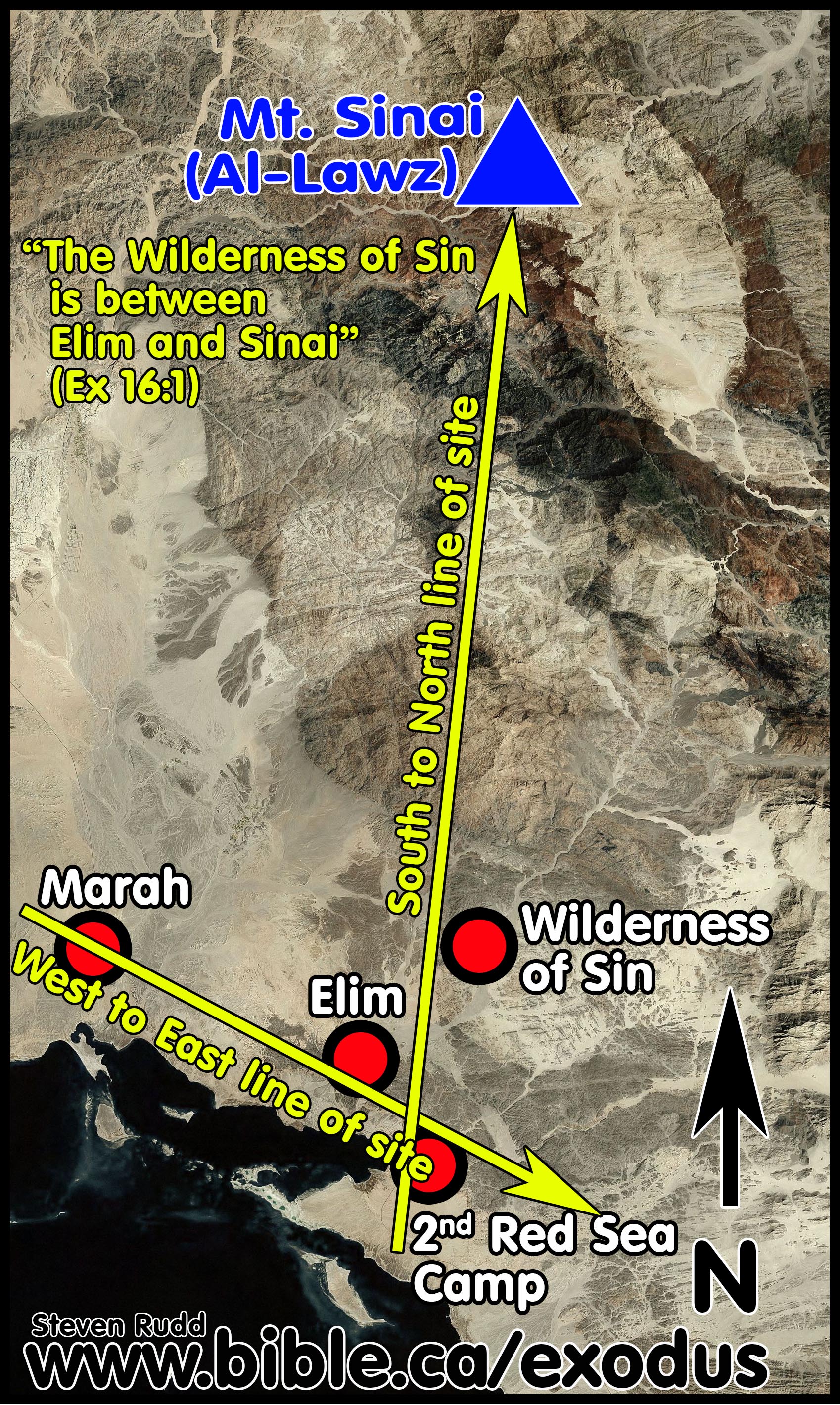
a. Elim must be close enough to the second Red Sea Camp that they are connected in some way, yet, remain distinct sequential stops.
b. In the Ex 16 narrative Moses routes directly from Elim to the Wilderness of Sin and skips the second Red Sea Camp. Moses included the second Red Sea camp in his detailed Num 33 itinerary, where the order is Elim, Second Red Sea camp, Wilderness of Sin. The solution is simple when you understand that the four stops, 2nd Red Sea camp, Elim, Wilderness of Sin, and Mt. Sinai, were arranged in a south to north line of sight. There is a west to east line of sight between Marah, Elim, and the second Red Sea camp.
c. Walking southeast from Marah, Israel camped at Elim, then continued in the same southeast direction for 10 km to reach the second Red Sea camp. Leaving the Second Red Sea camp for the Wilderness of Sin, Israel travelled north, passing Elim closely on the left side. The compass bearing upon entering Elim (From Marah) was the same compass bearing from Elim to the Red Sea as one straight line.
d. In this way, the entire congregation left Elim, visited the Red Sea, which was close to Elim, then passed Elim by on route north to the Wilderness of Sin.
e. Elim at Ain Ounah is a perfect fit for the Tiran crossing.
25. The 2nd Red Sea camp is close to the Wilderness of Sin:
a. The second Red Sea camp is one stop before the Wilderness of Sin so the two sites must therefore be close to each other. Most Nuweiba exodus route maps incorrectly mark the Wilderness of Sin far from the second Red Sea camp.
b. The Fritz route inserts an extra stop at Elim between the second Red Sea camp at Maqnah on the Gulf of Aqaba and the Wilderness of Sin.
c. The tiny number of exodus route maps drawn by Unicorn Internet Archeologists (UIA) often put the Wilderness of Sin far away from the Gulf of Aqaba and simply ignore the second Red Sea camp altogether.
26. Israel arrived as a single group at the Wilderness of Sin on the same day: Ex 16:1
a. Scripture says all 3 million Hebrews arrived at the Wilderness as a single group on day 31 from Goshen: Saturday, 15th day of the 2nd month, Iyar 15 (Ex 16:1).
b. The reason this is critical, is because it was on Iyar 15 (a Saturday) that Moses first revealed the 7-day Sabbath/Manna cycle in the Wilderness of Sin. They learned that Manna would fall for six days: Sunday to Friday, with a double portion on Friday. Then Saturday, the 7th day, they were to rest, and no Manna would fall. It is important that Israel arrived as a single group on a Saturday so they could all learn together about the Manna/Sabbath cycle.
c. The Glen Fritz Nuweiba crossing route splits the 3 million Hebrews into two groups when they first arrive at Elim (Al Bad). One group continues south to the Wilderness of Sin, arriving on Iyar 15 (Ex 16:1), while the second group travels one day through narrow canyons to modern Maqnah on the Gulf of Aqaba as the second Red Sea camp. This group retraces their steps back to Al Bad (Elim) then south to the Wilderness of Sin. The first group arrives at the Wilderness of Sin on Iyar 15 (Day 31) but the second group arrives two full days later on Iyar 17 (Day 33). This second group not only missed Moses’ instructions about the Sabbath/Manna cycle, for them, Quail suddenly appeared in the evening while they were at the second Red Sea camp, then the next day Manna suddenly appeared without explanation from Moses who was two days ahead. They then arrived at Elim on the second day of Manna while they camped for the second time at Elim on Monday. By the time the second group finally got to the Wilderness of Sin on Tuesday (the third day of Manna), the first group had already moved and were still two days ahead between Dophkah and Alush. The first group to arrive at the Wilderness of Sin experienced quail that same evening and Manna in the morning because they grumbled but the second group probably missed all this, being two days of travel away. This directly contradicts Ex 16:1-2 which twice says “all the congregation arrived” and “the whole congregation grumbled about food” the same day.
d. The Tiran route is a perfect fit for the entire 3 million Hebrews arriving at the Wilderness of Sin together as a single group on the same day.
27. The 8-day camp at the Wilderness of Sin to learn the Manna/Sabbath cycle:
a. In Ex 17:1, Israel camped a full 8 days at the Wilderness of Sin as a single group to learn the Sabbath/Manna cycle before moving to Dophkah: "THEN all the congregation of the sons of Israel journeyed by stages from the Wilderness of Sin, according to the command of the Lord, and camped at Rephidim" (Exodus 17:1)
b. Israel arrived on Saturday, camped 8 days (days 31-38, Iyar 15-22, Saturday to Sunday) at the Wilderness of Sin then left for Dophkah the following Sunday. Only after all the events in chapter 16 had occurred did all the congregation “THEN” leave the Wilderness of Sinai.
c. Glen Fritz completely missed this important 8-day camp at the Wilderness of Sin to learn the Sabbath/Manna cycle and allowed only one camp day at the Wilderness of Sin. Fritz split the congregation up into two separate travel groups, two days apart. The first group arrives at the Wilderness of Sin on Iyar 15 as per Ex 16:1, then leaves for the unbiblical “third Red Sea Camp” after only one camp day, before continuing to Dophkah. The second group arrives at the Wilderness of Sin two days later on Iyar 17, completely missing Moses’ instruction about the Manna/Sabbath cycle while the first group has already moved from Dophkah and is arriving at Alush.
d. The Tiran route is a perfect fit but the Fritz’s Nuweiba route directly contradicts scripture.
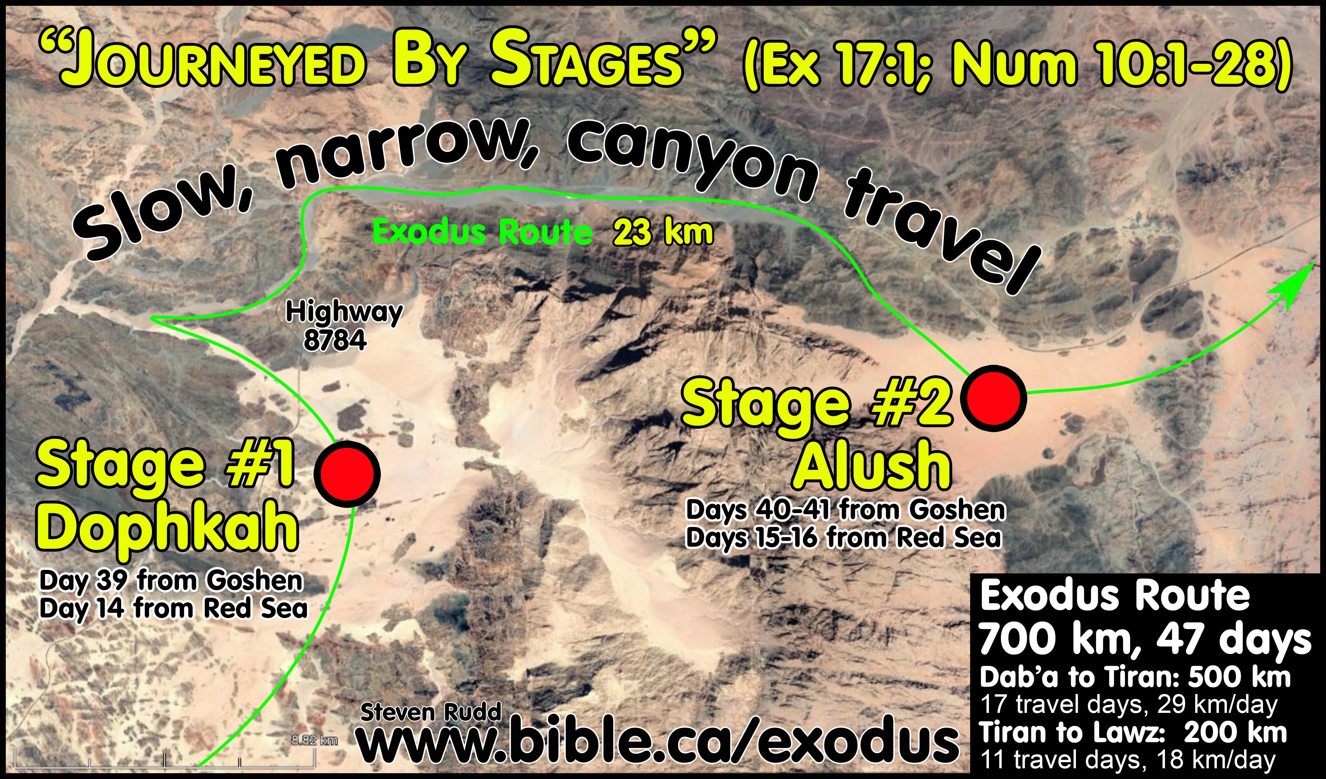
28. Journeyed
in small “stage” groups between Dophkah and Alush: The Bible indicates that
the only difficult and narrow terrain through canyons during the entire 47-day
journey were the two stages (Dophkah and Alush) between the Wilderness of Sin
and Rephidim. They were unable to travel as a single unified group so they
travelled in smaller groups or “stages” through the narrow and difficult canyon
portion of the route until they reached Rephidim: Num 33:12-13; Ex 17:1.
Another synchronism is that the Amalekites attacked (Exodus 17:7-8) the rear of
the second day stage groups on transit to Rephidim: “Remember what Amalek did
to you along the way when you came out from Egypt, how he
met you along the way and attacked among you all the stragglers at your rear when
you were faint and weary; and he did not fear God." (Deuteronomy 25:17–18)
It was a brilliant military move that the Amalekites attacked the final group,
while the first group has already complained about a shortage of water at
Rephidim.
|
Biblical Exodus Route Terrain Heuristic They Journeyed by stages between the Wilderness of Sin and Rephidim: Ex 17:1 |
||||
|
Route |
Terrain expected from Bible narrative in Exodus 17:1 |
Tiran Terrain encountered Steven Rudd1 |
Nuweiba Terrain encountered Gordon Frantz2 |
Ballah Terrain encountered Glen Fritz3 |
|
Goshen to Red Sea camp |
Easy |
Easy |
Easy |
Difficult and narrow before Nuweiba |
|
Red Sea camp to Wilderness of Sin |
Easy |
Easy |
Easy |
Difficult and narrow |
|
Easy |
Easy |
Easy |
Easy |
|
|
Difficult and narrow |
Difficult and narrow |
Easy |
Difficult and narrow |
|
|
Alush to Sinai |
Easy |
Easy |
Easy |
Easy |
|
Sinai to Kadesh |
Easy |
Easy |
Difficult via Ezion Geber |
Easy |
|
Assessment |
|
|
|
|
|
1: Rudd: Red sea crossing is at Tiran, Mt. Sinai is Lawz, Kadesh is at Petra. 2: Frantz: Red sea crossing is at Ballah, Mt. Sinai is Sin Bisher, Kadesh is at Qudeirat. 3: Fritz: Red sea crossing is at Nuweiba, Mt. Sinai is Lawz, Kadesh located inside Simeon/Judah. |
||||
a. In only two places during the exodus, does scripture say (Ex 17:1; Num 10:12-28) that Israel journeyed in small “stage” groups.
i. First, between the Wilderness of Sin and Rephidim because the difficult terrain would not allow them to move as a single group of 3 million.
ii. Second, upon leaving Mt. Sinai when small ceremonial “stage” groups left in a predetermined sequential order when the trumpet was called.
iii. “nāsaʿ is also used in the sense of to “journey by stages.” Headed for Sinai, the Israelites “moved on from the Wilderness of Sin by stages” (pl. of massaʿ, Ex 17:1). Later they “set out by stages from the Wilderness of Sinai” (Num 10:12).” (Theological Wordbook of the Old Testament, 1380 נָסַע, p584, Marvin R. Wilson, 1999 AD).
iv. While the same word is used for each stage from Goshen to Canaan (Num 33), these two texts represent special and unique cases (Ex 17:1; Num 10:12-28).
b. The same Hebrew word for stages is nāsa’ (Strongs 4550) and is used in Num 33, Ex 17:1, and Num 10:12-28
i. 50 camp stops from Goshen to Canaan: "These are the journeys [Stages- nāsa’ - Strongs 4550] of the sons of Israel, by which they came out from the land of Egypt by their armies, under the leadership of Moses and Aaron. Moses recorded their starting places according to their journeys [Stages- nāsa’ – Strongs 4550] by the command of the Lord, and these are their journeys [Stages- nāsa’ – Strongs 4550] according to their starting places." (Numbers 33:1–2)
ii. Canyon travel after the Wilderness of Sin: "Then all the congregation of the sons of Israel journeyed by stages [Stages- nāsa’ – Strongs 4550] from the Wilderness of Sin, according to the command of the Lord, and camped at Rephidim." (Exodus 17:1)
iii. Individual stage units leave Mt. Sinai in a sequential order of small groups after each trumpet blast: "The Lord spoke further to Moses, saying, “Make yourself two trumpets of silver, of hammered work you shall make them; and you shall use them for summoning the congregation and for having the camps set out [Stages- nāsa’ - Strongs 4550]. ... “When you blow an alarm the second time, the camps that are pitched on the south side shall set out; an alarm is to be blown for them to set out [Stages- nāsa’ - Strongs 4550]. … “Now in the second year, in the second month, on the twentieth of the month, the cloud was lifted from over the tabernacle of the testimony; and the sons of Israel set out on their journeys [Stages- nāsa’ - Strongs 4550] from the Wilderness of Sinai. Then the cloud settled down in the wilderness of Paran. So they moved out for the first time according to the commandment of the Lord through Moses. The standard of the camp of the sons of Judah, according to their armies, set out first, with Nahshon the son of Amminadab, over its army. … This was the order of march [Stages- nāsa’ - Strongs 4550] of the sons of Israel by their armies as they set out." (Numbers 10:1–28)
c. Only the Red Sea crossing at the Straits of Tiran to Sinai is a perfect geographic match for journeying in stages between the Wilderness of Sin and Rephidim. The 700 km Tiran crossing exodus route to Mt. Sinai has only one 23 km section of difficult or narrow canyon travel which represents only 3% of the entire journey. All the rest of the route is easy, flat and wide.
d. The 888 km Nuweiba crossing exodus route to Mt. Sinai has three sections of difficult or narrow canyon travel that add up to a whopping 273 km and represents 31% of the route. One third of the entire Nuweiba route needed to be travelled in small group stages rather than all together as one large unit of 3 million. This contradicts scripture that says they only needed to journey in stages between Dophkah and Alush.
e. The result is that the Tiran route can easily arrive at Mt. Sinai on day 47 but the Nuweiba route arrives on day 64 according to Glen Fritz’s.
|
Summary of Fritz Nuweiba Route terrain difficulty heuristic (TDH) |
||||
|
Nuweiba Crossing |
Easy |
Challenging |
difficult |
Distance |
|
Goshen to Mt. Sinai |
239 miles 383 km |
145 miles 232 km |
171 miles 273 km |
555 miles 888 km |
29. The 5-day camp at Rephidim:
a. First camp day at Rephidim (Wednesday, day 42): The first Hebrews arrive at Rephidim at the head of a long precession travelling in small group stages between Dophkah and Alush. They complain about no water and God tells Moses that when he later gets to Mt. Horeb (i.e. Mt. Sinai: Ex 17:6) there he will strike the rock to split it so water comes out for the 3 million Hebrews during their 11 month stay camped at Mt. Sinai. Rephidim is not the location of the “split rock” it is where Israel complained about no water. The Amalekites attack (Ex 17:8) those navigating the canyons between Dophkah and Alush and set up a major attack at Rephidim. It was a brilliant strategic military maneuver for the Amalekites to attack while Israel travels for the first time in small stage groups through canyons as opposed to travelling as one large single unit of 3 million in a wide open space. That evening Moses readies the Hebrew army to counterattack in the morning as more and more Hebrews arrived from the canyons of Alush.
b. Second camp day at Rephidim: (Thursday, day 43): As more Hebrews arrived from the canyons of Alush sometimes the Amalekites prevailed in the battle and sometimes the Hebrews. Moses finally stood on a hilltop and held his hands up to defeat the Amalekites till sunset. Moses built a memorial altar (Ex 17:15). Jethro visited Moses after the defeat of the Amalekites at Rephidim but before they reached Mt. Sinai. Jethro arrived with Moses’ wife Zipporah and his two sons, entered Moses’ tent to talk. Jethro offered sacrifices and the heads of Israel ate a meal likely in part to celebrate the defeat of the Amalekites (Ex 18:12). Midian was the home of Jethro, at Al Bad, where Moses lived for 40 years yet the Biblical itinerary never says Moses camped at Midian. The Nuweiba route of Glen Fritz has Israel camping at Midian (Fritz’s Elim) 3 days but Moses never mentioned this. If Moses passed right through Midian this is when Jethro would have visited Moses. Moses would already have collected his wife and two sons before reaching the Wilderness of Sin. This falsifies the Nuweiba crossing because Moses would have surely mentioned that Israel camped 3 entire days at Midian located at modern Al Bad.
c. Third camp day at Rephidim: (Friday, day 44) After the Amalekites were defeated, the Hebrews woke up to their second “double portion” of manna because the next day is the second Sabbath day. As the last of the Hebrews completed the journeying in stages between Dophkah and Alush, Moses waited for everyone to arrive as a single group of 3 million again, before travelling to Mt. Sinai. Moses used the period of waiting to judge from morning to night the civil disputes of the people while Jethro watches it all (Ex 18:13).
d. Fourth camp day at Rephidim: (Sabbath, day 45) This is only the second weekly Sabbath day since creation. Adam, Moses and Abraham never kept the weekly Sabbath day because it was first revealed in 1446 BC. Jethro takes advantage of the Sabbath as a day of reflection to advise Moses to appoint men over groups of 1000’s, 100’s and 10’s to help Moses judge the people (Ex 18:17).
e. Fifth day at Rephidim: (Sunday, day 46) In the morning, Moses implements the advice of Jethro and appoints men over 1000’s, 100’s and 10’s to judge the people. Jethro leaves Rephidim and returns to Midian (Ex 18:27). Moses departs Sunday Iyar 30 in the day and arrives after sunset at the final camp at Mt. Sinai Sunday evening, which is Sivan 1, day 47 (Ex 19:1). The third new moon rises overnight as the 3 million Hebrews are camped in front of Mt. Sinai, marking the beginning of the month of Sivan. The next morning, (Monday Sivan 1, day 47) Moses brings water from the “split rock” on Sivan 1 at Horeb (Ex 17:6) which will be the main water supply for the next 11 months. A few days later, Moses tells the entire camp of Hebrews to wash their clothes (in this water supply from the split rock) and be ready for God to reveal the Law of Moses and the Ten Commandments three days later on the day of Pentecost.
i. “When Jethro offered sacrifices, however, they were to God (ʾelohim). The juxtaposition of the two names indicates that his path did not lie with this newly forming people of Yahweh. He did not follow the presence of the Lord to Sinai, or “serve” him with Israel. Instead he returned to Midian, believing in the Lord God. Jethro was a model of hope for Gentiles, very early in biblical tradition, that the promise God made to Abraham, Jethro’s common ancestor with Moses, would be fulfilled. The placement of his narrative just before the giving of the law at Sinai and the Lord’s specific covenant with Israel is not accidental. Israel would have a special relationship with the Lord because of its creation through the experience of the sea and its early formation at the mountain of God. By including the story of Jethro at this juncture, Israel’s Scriptures acknowledged the possibility of righteous Gentiles who feared God and lived accordingly.” (Understanding the Bible Commentary Series, James K. Bruckner, Exodus 18:1, 2012 AD)
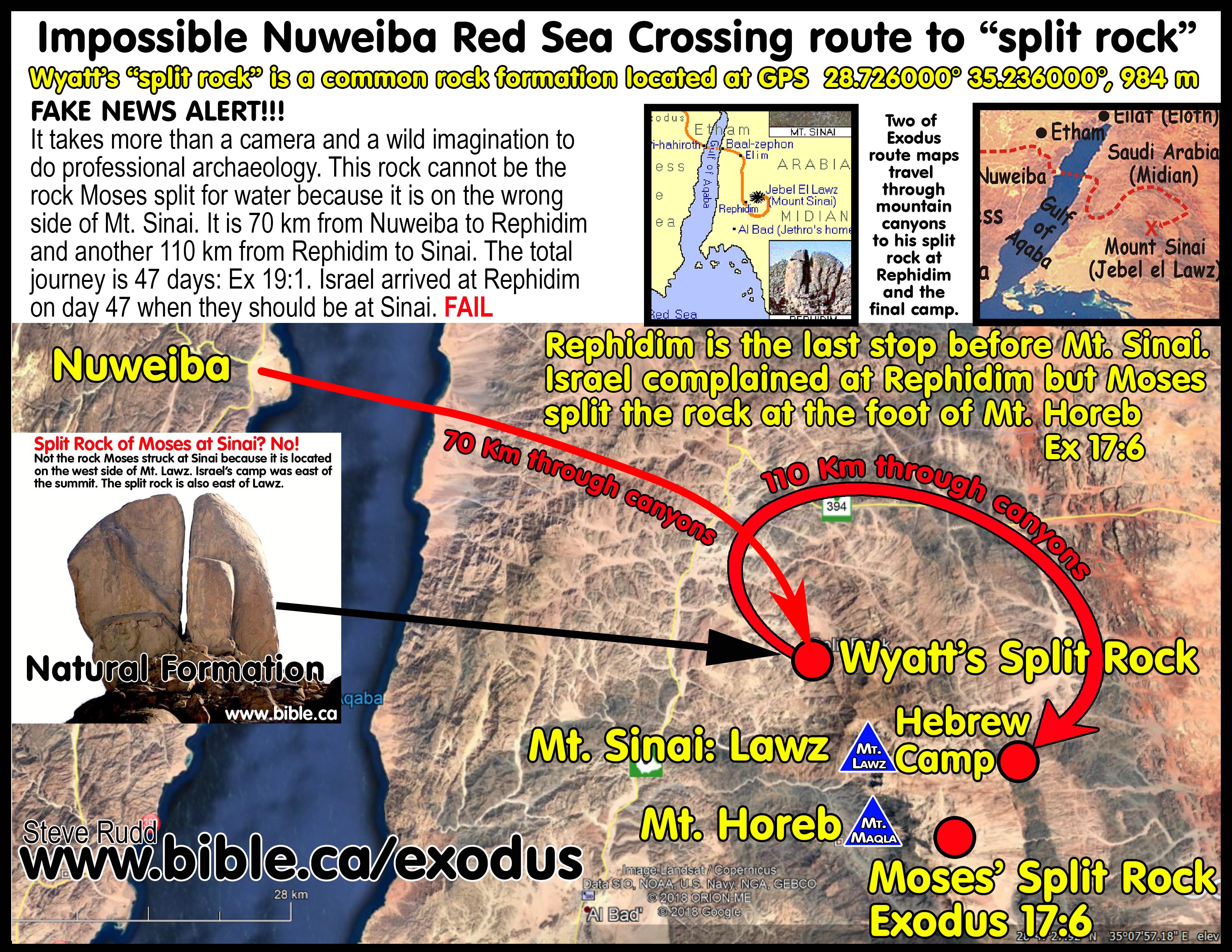
30. Rephidim is close to Mt. Sinai: Rephidim is one stop from
Mt. Sinai so the two sites must therefore be close to each other. Ron Wyatt’s
infamous split rock at Rephidim must be rejected because it is on the wrong
side of the mountain range and impossibly far from the final Hebrew camp at Mt.
Sinai. It is 70 km from Nuweiba to the “split rock” at Rephidim, then another
110 km to reach Mt. Sinai in one stop.
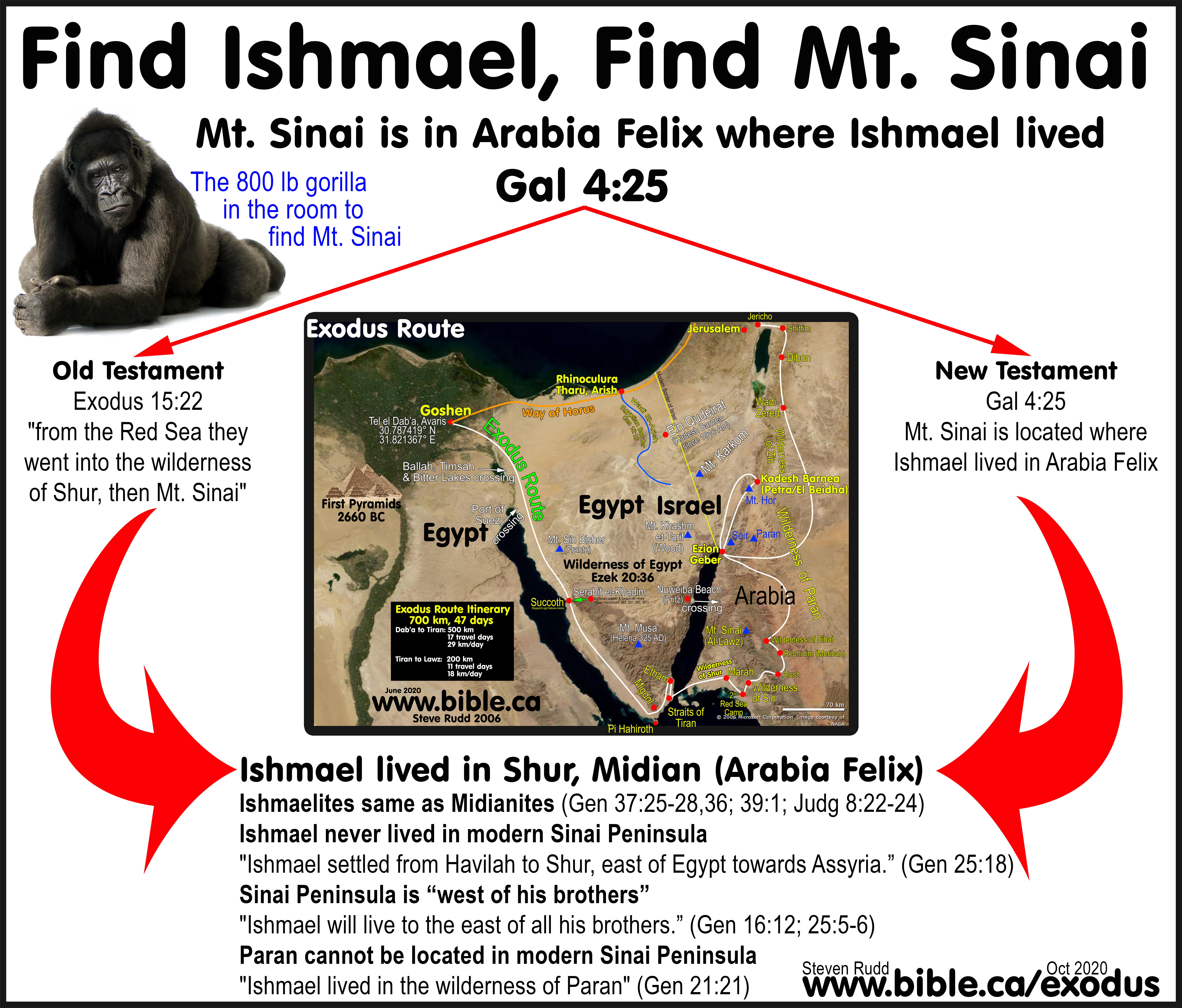
31. Find Ishmael, find Mt. Sinai: Paul said In Gal 4:25 that Mt.
Sinai was in Arabia and some mistakenly search for Arabia in Paul’s day to
locate Mt. Sinai. Paul gave a second identifier for the location of Mt. Sinai
that most have missed: “Hagar is Mount Sinai in Arabia”. In the allegory, Hagar
is Mt. Sinai and Hagar’s children were the Ishmaelites. At the time of Joseph,
the Ishmaelites and Midianites had intermarried to become one tribal unit.
There is universal agreement that Midian was in North Saudi Arabia near Al Bad.
Forget trying to find Arabia in Paul’s day, find Ishmael in Moses Day. Find
Ishmael and you find Mt. Sinai in the land of Midian in north Saudi Arabia.
32.
Hagar’s two flights to Shur were south of not west of
Hebron and Gerar:
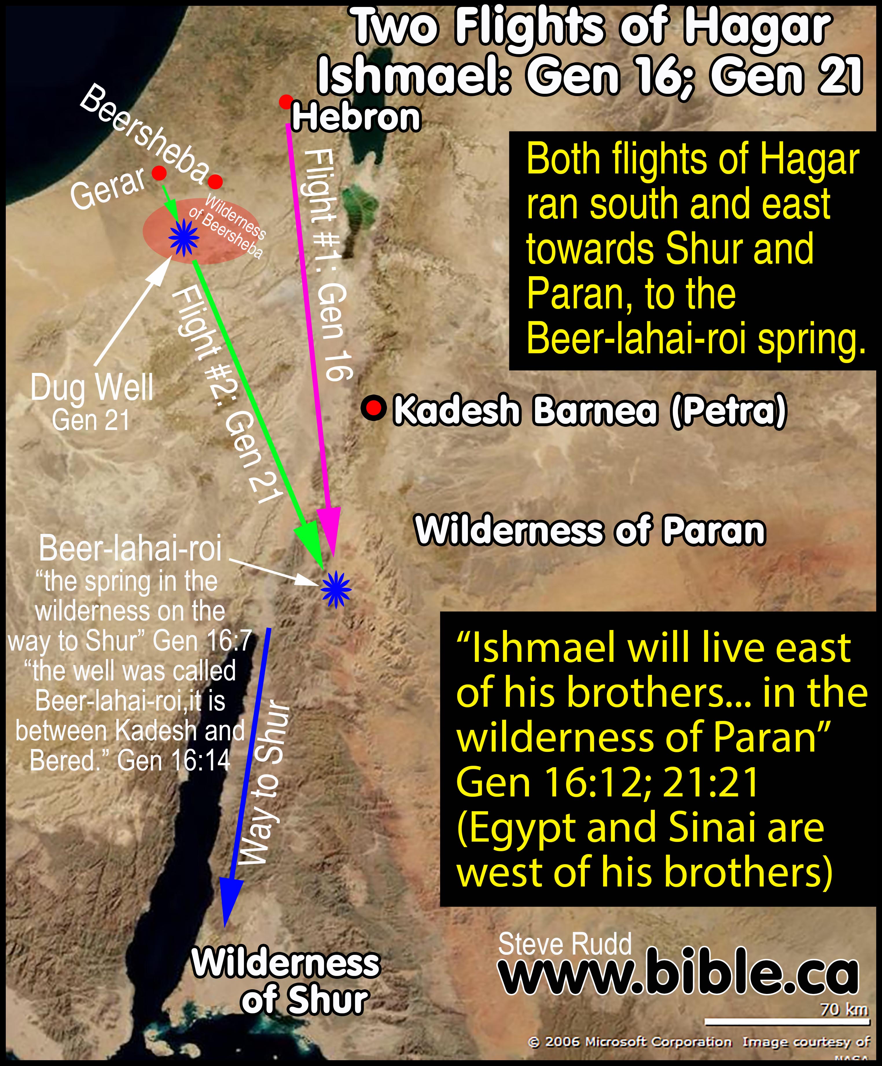
a. Chronology and itinerary of Hagar’s first flight from Hebron (Gen 16): Abraham lived in Hebron (Genesis 13:18) where Ishmael was born in 2080 BC when Abraham was 86 years old (Gen 16:16). Probably at the age of 4 years old after Ishmael was weaned and drank water, Sarah mistreated Hagar at Hebron around 2076 BC. Hagar ran south in the direction of “the way to Shur” and found a spring called Beer-lahai-roi, which was located “between Kadesh (Petra) and Bered” (Gen 16:7,14). We don't know for sure where this spring or Bered are located. However, between Kadesh Barnea at Petra and the Way to Shur give us the general area. Since both Kadesh Barnea (Petra) and the Wilderness of Shur (Midian) are Transjordan, we can safely place the "Beer-lahai-rio" spring somewhere within the Wilderness of Paran in modern Jordan near Ezion Geber. Hagar left the spring at Beer-lahai-rio and returned to Hebron to submit to Sarah. While at Hebron (Gen 18:1) the angels fortell the birth of Isaac and then destroy Sodom and Gomorrah (Gen 19) for deviant sex. It was after the destruction of Sodom and Gomorrah in 2067 BC that Abraham moved south to the same place Hagar had fled years earlier, perhaps to the spring “Beer-lahai-roi”. Hagar must have told Abraham about the “Beer-lahai-roi” spring because Abraham then left Hebron and moved to the same basic area as the first flight of Hagar. "Now Abraham journeyed from there toward the land of the Negev, and settled between Kadesh (Petra) and Shur (Midian); then he sojourned in Gerar." (Genesis 20:1). This is Transjordan and in the same basic area as the Beer-lahai-rio spring. Notice that Abraham moved to Gerar not Hebron.
b. Chronology and itinerary of Hagar’s second flight from Gerar (Gen 21): Abraham moves from the “Beer-lahai-roi” spring to Gerar where Abimelech, the Philistine king of Gerar (Gen 26:1) takes Sarah for his wife (Gen 20:2). Isaac is born at Gerar (not Hebron nor Beersheba) in 2066 BC when Abraham was 100. During the three months that followed the destruction of Sodom and Gomorrah, Abraham moved from Hebron to the Beer-lahai-rio spring, then to Gerar where Abimelech took Sarah as his wife. It was after Abimelech returned Sarah to Abraham that she conceived Isaac who was born 9 months later in 2066 BC or 1 full year after the destruction of Sodom in 2067 BC. After Isaac was weaned at Gerar, Abraham and Sarah banished Hagar around 2064 BC when Isaac was about 2 years old and Ishmael was 16 years old. Hagar leaves Gerar and again travels south towards the wilderness of Beersheba when God opened her eyes to a dug well of water. The Bible then says that Ishmael “lived in the wilderness of Paran" (Gen 21:21). Abraham had been living in Gerar for about 3 years when Hagar was banished. After Hagar fled, the next scene is the covenant Abimelech makes with Abraham at the well Abraham dug at Beersheba (Gen 21:32). This is where the city of Beersheba gets its name. While it is not certain whether Hagar fled from Gerar or Beersheba, we can be certain that she did not flee from Hebron. It seems likely that Hagar fled from Gerar while Abraham was in the process of permanently moving to Beersheba. After getting assurances from Abimelech about ownership of the land surrounding the well at Beersheba, it is certain that Abraham then moved to Beersheba.
c. Hagar’s flight was south from Gerar to Beersheba, not west from Hebron to Beersheba. This proves the Wilderness of Shur is nowhere near the Suez Canal or the Bitter lakes. The direction of Hagar’s second flight leads towards Elat and is a perfect fit for Shur being in Saudi Arabia. In the story of Joseph being sold to the Ishmaelites, the narration describes the Ishmaelites interchangeably as Midianites multiple times. This proves that Ishmael lived in Midian because they had intermarried. Find Ishmael and you find Midian and Sinai.
d. The two flights of Hagar and the move of Abraham are both the same basic direction towards Elat and end in the same place: the wilderness of Paran.
33. The Hebrew camp was east of the summit of Mt. Sinai: Moses would have accessed the tabernacle from the east looking west to facilitate the Holy of Holies being closest to the Mountain. The priests entered the tabernacle with their backs to the rising sun. The main Hebrew camp would be located on the east side of the summit of Mt. Sinai.
34. The Ezion-Geber Enigma: Mt. Sinai to Ezion-Geber to Kadesh
Barnea: Many exodus route maps skip Ezion Geber as a stop because of the
serious problems this location causes in presenting a logical route to Kadesh
Barnea from Mt. Sinai. Exodus route maps that ignore Ezion Geber are wrong.
There were 22 camps between Mt. Sinai and Kadesh Barnea. Ezion Geber was the
last stop before Kadesh Barnea and the two sites must therefore, be close to
each other. Mt. Sinai candidates located in the Sinai Peninsula like Mt. Musa
and Khashm et-Tarif require navigation through an impassible mountain range to
reach Ezion Geber. William Schlegel, who suggests the traditional Mt. Sinai at
Mt. Musa, routes the Hebrews through the Nuweiba beach, and up the coast to
Ezion Geber to avoid these mountains. Bryant Wood favours Mt. Khashm et-Tarif
as Mt. Sinai, but his route to Kadesh Barnea at Qudeirat must traverse
impassable mountains to get to Ezion Geber, then traverse the same impassable
mountains a second time in 1444 BC. Then in 1407 BC Moses must traverse this
same impassable mountain range a third time from Kadesh back through Ezion
Geber to the Jordan River during the conquest. These mountain ranges north of
Elat are avoided by locating Mt. Sinai in Arabia then travelling through Ezion
Geber to Kadesh Barnea at Petra. As the last stop before arriving at Kadesh,
Ezion Geber is an easy downhill walk towards the Salt sea. Mt. Lawz is a perfect
fit through Ezion Geber to Kadesh Barnea at Petra!
The Ezion-Geber Enigma for Bryant Wood is:
a. The Red Sea to Mt. Sinai at Khashm et-Tarif: 8 stops to travel 260 km.
b. Mt. Sinai at Khashm et-Tarif to Ezion-geber: 21 stops to travel 30 km through impassable mountains.
c. Ezion Geber to Kadesh Barnea at Qudeirat: 1 stop to travel 140 km through impassable mountains.
d.
Kadesh Barnea at Qudeirat to Ezion Geber: 1 stop to travel 140 km
through impassable mountains.

35. The Wadi el-Arish is the historic border between Egypt and
Israel: The Southern border of the promised land is the Wadi el-Arish
(River of Egypt): Gen 15:18; 1 Ki 8:65; 2 Ki 24:7; 2 Chr 7:8; Isa 27:12; 2 Chr
9:26; 1 King 4:21; Jer 2:18; Ex 23:31. This automatically rules out Kadesh
Barnea at Ain el Qudeirat and Mt. Sinai at Mt. Karkom because Moses did not
spend 40 years in the promised land after leaving Egypt.
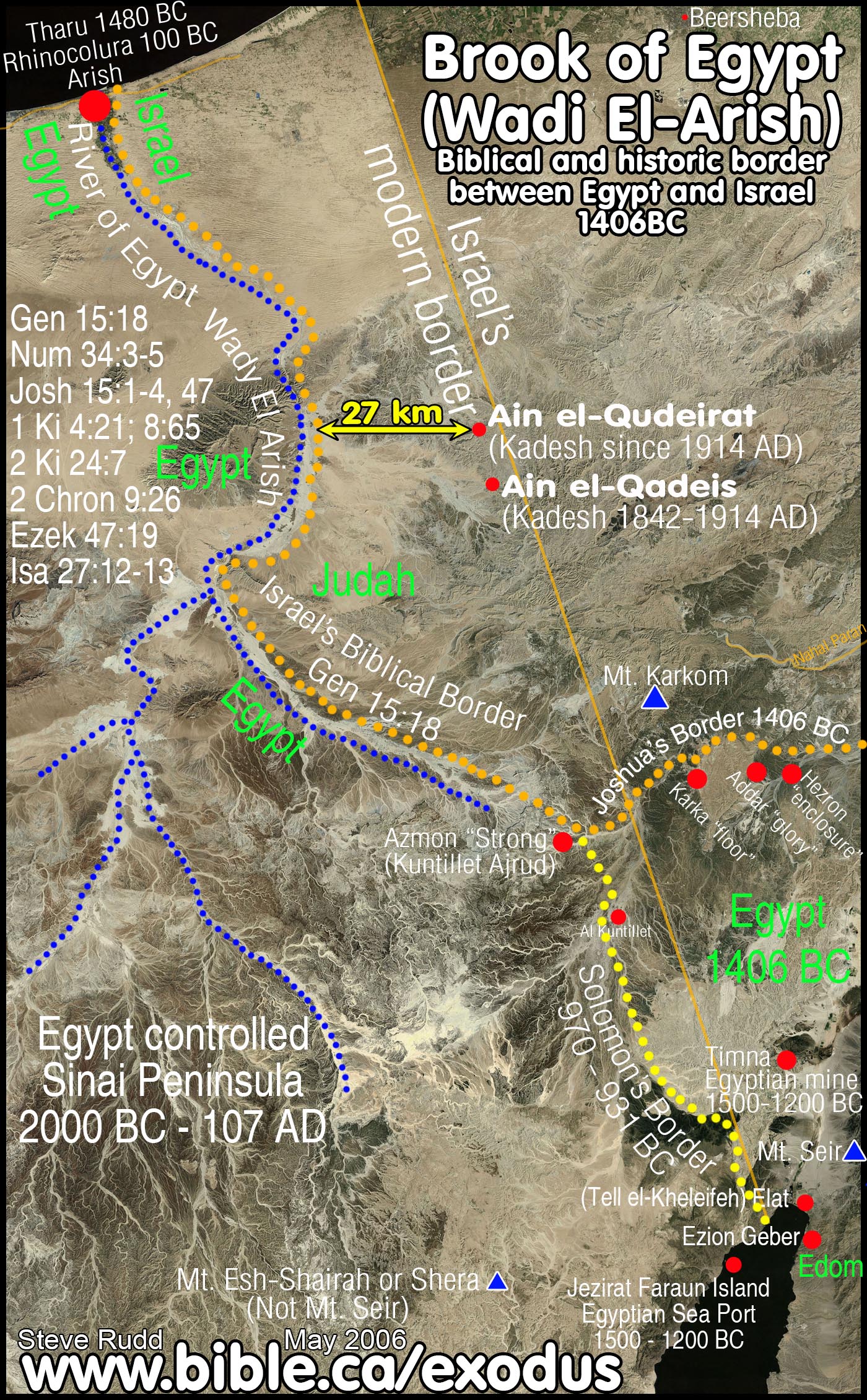
a. Ancient Egyptian literary sources that equate Tharu = Rhinocorura = Arish
i.
The seaport of modern Arish was ancient Tharu where a Late Bronze age
prison camp held inmates who had their noses cut off. “Let the law be applied
to him by cutting off his noe and sending him to Tharu” (Great Edict Stela of
Horemheb, 1328 BC). The photo is of a woman named Zahida Perveen, whose Muslim
husband came home from the mosque and cut off her nose, ears, tongue, gouged
out her eyes, and left her for dead as punishment for her suspected infidelity
which she denied.
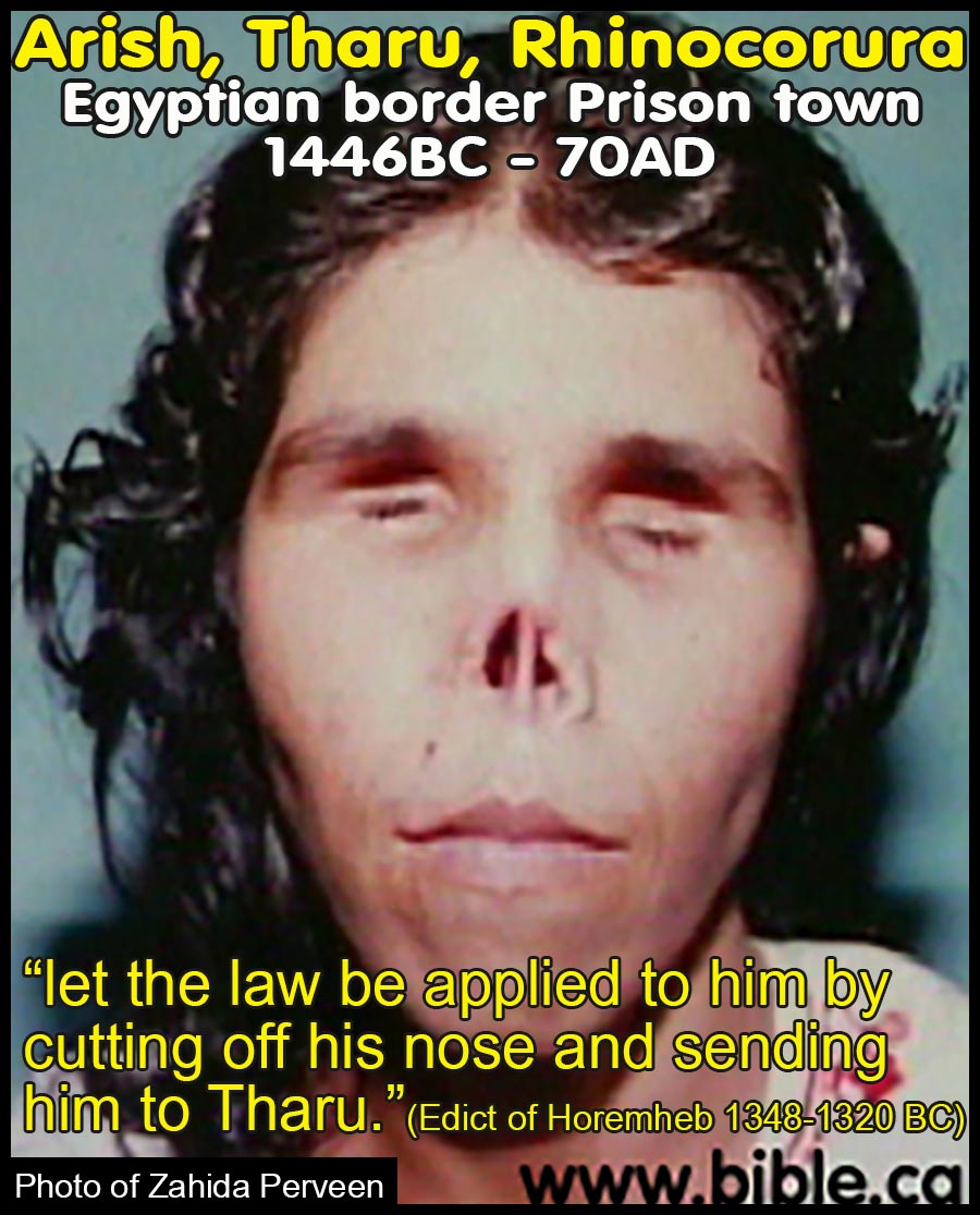
ii. Tharu was a Late Bronze age Egyptian fortress located on the border of Egypt as a last stop before entering Canaan at Raphia and Gaza. (The Battle of Megiddo by Pharaoh Menkheperre, Thutmoses III, 1462 BC).
iii. The fortress of Tharu was on the border of Egypt (Relief of Menmaatre Seti I: 1300 BC and the Poem of Pentaur on the Battle of Kadesh).
b. Ancient Greek literary sources that Tharu = Rhinocorura = Arish:
i. 50 BC: Diodorus Siculus said that in 550 BC Actisanes [king of Ethiopia at the time of Amasis II] renamed Tharu Rhinocorura (Diodorus Siculus, Bibliotheca historica, Book 1, 60:1-10).
ii. AD 15: Strabo confirms that Rhinocorura is the same Egyptian border town as Tharu in 1450 BC. (Strabo, Geographia, XVI,2,31-32).
c. Ancient literary sources confirm Wadi el-Arish is the River of Egypt in Gen 15:18:
i. 670 BC: Esarhaddon’s 10th campaign says the Brook of Egypt had no water! (ANET 292, Esarhaddon)
ii. 250 BC: The Septuagint (LXX): substitutes "the brook of Egypt" in Isa 27:12 for Rhinocorura,
iii. 150 BC: Polybius: Rhinocorura is the border of Egypt (Polybius, Histories 5:80)
iv. 100 BC: Judith 1:9: River of Egypt is not the Pelusiac branch of the Nile
v. AD 110: Josephus: Simeon borders Egypt (Sinai Peninsula) and Arabia (Petra); Rhinocurura is in Egypt
vi. AD 325: The Onomasticon by Eusebius marks Rhinocorura at Arish.
vii. AD 400: Jerome: Raphia is near the border of Egypt (Jerome, commentary on Daniel 11:10-14)
viii.
AD 542: Madaba Map: States in Greek that Egyptian border is between
Raphia and Rhinocorura
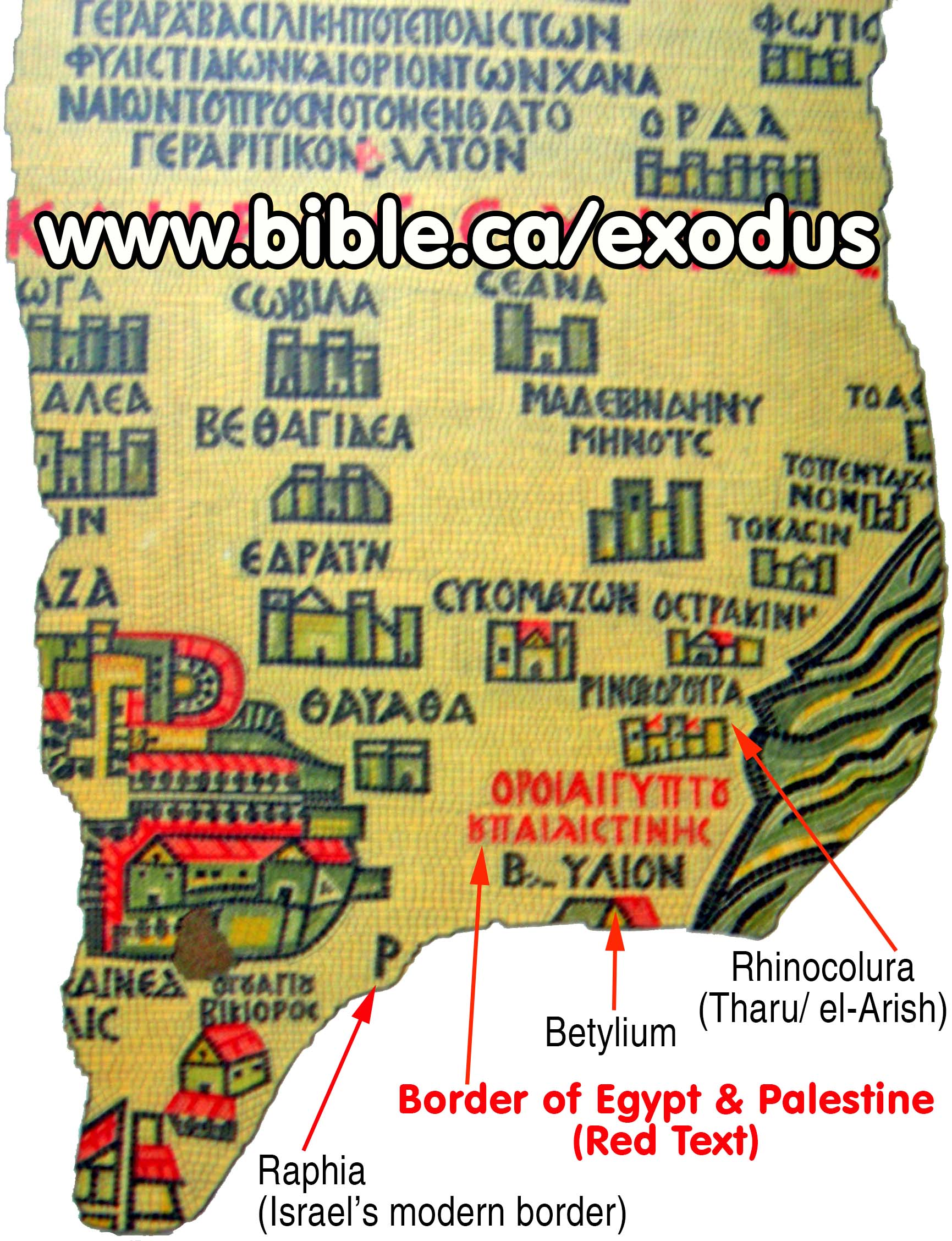
36. The southern border of Judah proves Kadesh Barnea is near or at
Petra: Num 34:3-5; Josh 15:1-4.
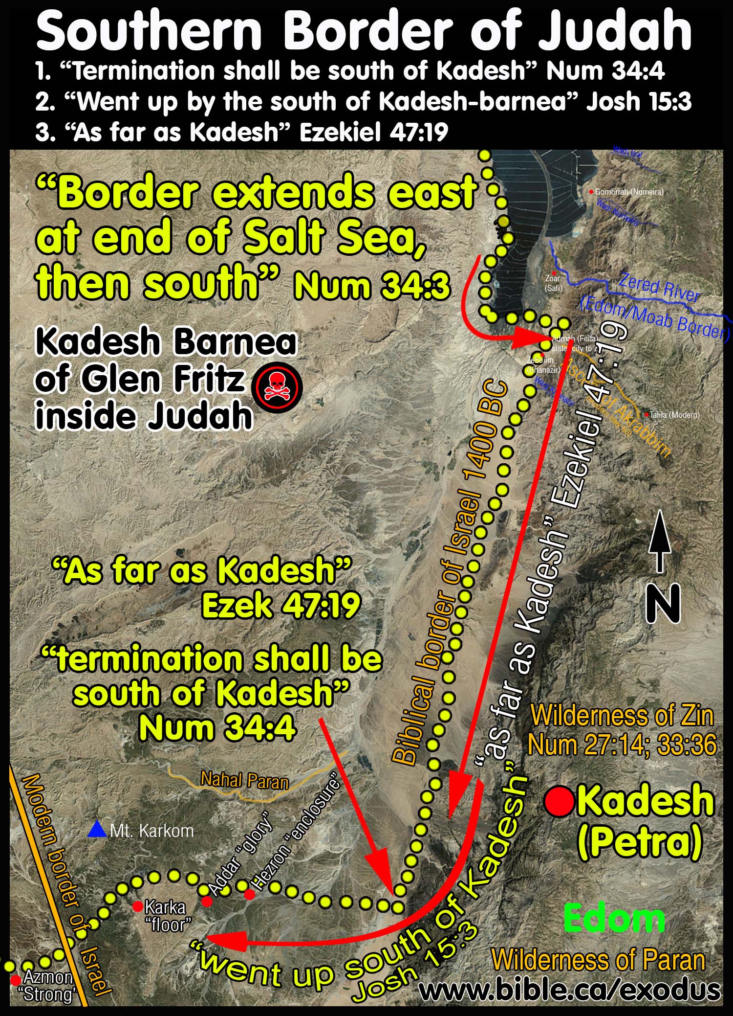
a. Moses draws the border of Judah along the western coast of the Dead Sea to the southern end, then turns east, then south towards Kadesh Barnea. Once the border passes Kadesh Barnea on the left, as a marker outside the promised land, the border then turns west towards the Wadi Arish and ends at the Mediterranean Sea. Scripture says “your southern border shall extend from the end of the Salt Sea eastward.” (Num 34:3).
b. Glen Fritz located Kadesh Barnea 35 km east of Ein Hatseva (Hormah) which is deep inside tribal Judah and must be rejected out of hand. Israel did not spend 38 years in the land of Judah.
c.
Since AD 1916 Kadesh has been misplaced at Ain el-Quderiat, which is 27
km east of the River of Egypt, the boundary between Egypt and Israel. It is
puzzling why Christians miss the fact that when scripture says that the
boundary of Judah “went up to the south of Kadesh” that Kadesh cannot be inside
the promised land.
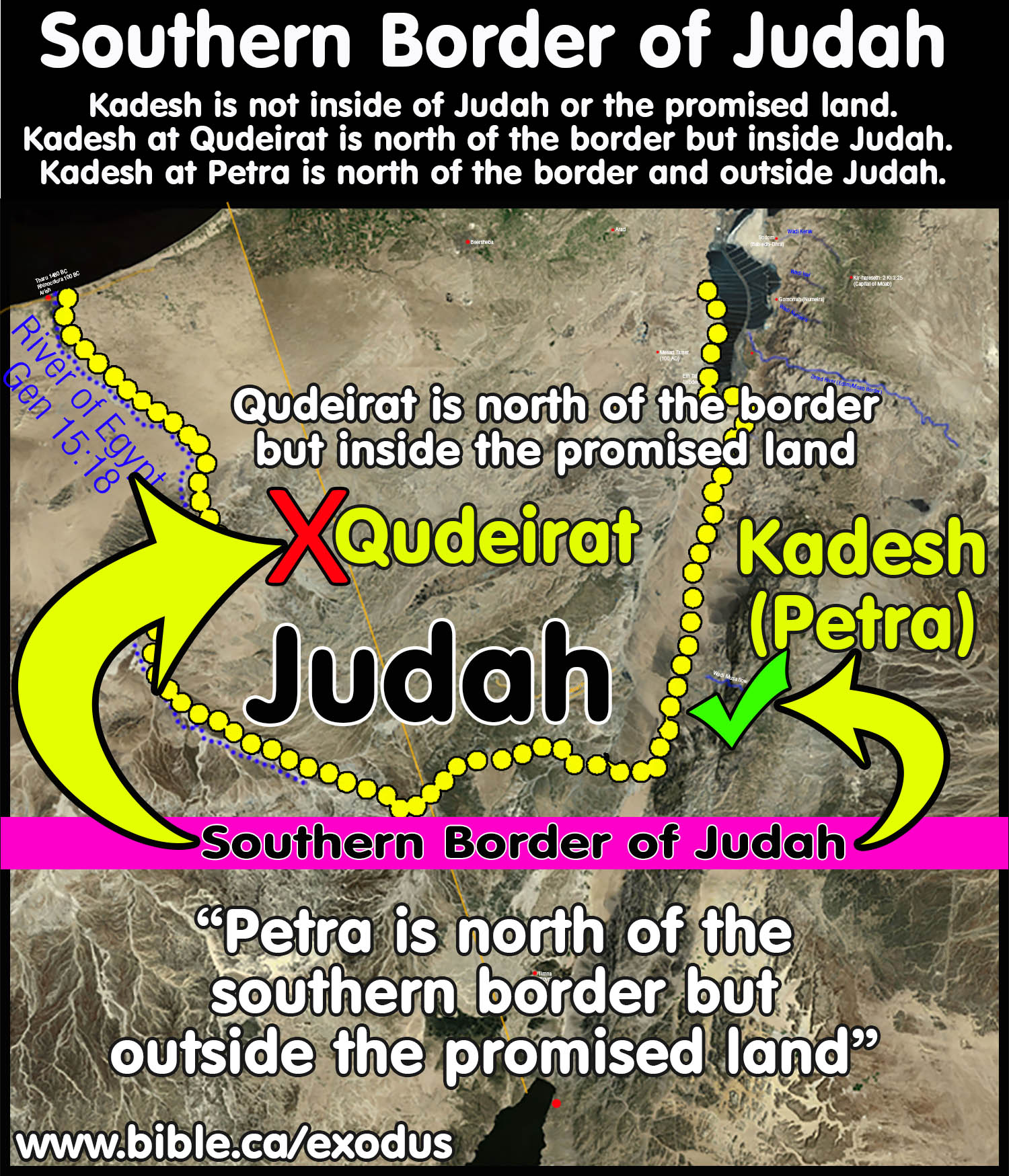
37. Moses spent 38 continuous years at Kadesh Barnea:
a. In 1446 BC Israel spent 11 months, 5 days at Mt. Sinai (Numbers 10:11-12). In 1444 BC, Moses arrived at Kadesh Barnea in the 1st month of the 3rd year (Numbers 10:11; 20:1) then spent 38 continuous years at Kadesh Barnea until they left for Canaan in 1407 BC.
b. Aaron died on the 1st day of the 5th month of the 40th year of the wilderness wandering (summer 1407 BC). Shortly after mourning Aaron for 30 days, the people left Mount Hor, defeated the Transjordan nations, and then mourned for Moses 30 days.
c. Joshua crossed the Jordan on the 10th day of the 1st month of the 41st year (spring, 1406 BC), four days before the 41st Passover, which was exactly 40 years to the day they left Goshen. They started counting sabbatical years and Jubilee after crossing the Jordan. (Num 33:38; 20:28; Deut 34:8; Josh 4:19; 5:10)
38. Edom did not live in the Negev at the time of the Exodus: Edom was a Transjordan nation at the time of the Exodus and did not occupy Judah or any land southwest of the Salt Sea in the Negev. Those who place Kadesh Barnea at Qudeirat create the fiction that Edom occupied the Negev east of Qudeirat across the southern Arabah Valley in modern Jordan. They bring the western border of Edom deep into Judah and mark it directly beside Qudeirat.
a. The first incursion of Edom into the tribal allotment of Judah and Simeon did not occur until after the first attack of Nebuchadnezzar in 605 BC. This is validated through the Arad Ostraca.
b. At age 30, Esau moves from Judah to Seir, conquered the Horites in 1926 BC and began to occupy their historic Transjordan territory east of the Arabah valley in the highlands of modern Jordan. During the time of the Exodus 1446 BC, Edom's territory ran beside Kadesh Barnea at Nabatean Petra from the gulf of Aqaba north to the Wadi Zered at the south end of the Salt Sea. After continuously occupying their historic Transjordan lands for 1321 years, they began to move west into the Judean Negev, for the first time, after Nebuchadnezzar's first attack on Jerusalem in 605 BC.
c.
By 597 BC the Edomite
Threat became very serious when one of the four Negev Judean
fortresses, Ramah-Negev, was about to be captured by the Edomites. Zedekiah
issues orders to Malchijah, the troop commander at the Arad fortress, to send
troops from Arad and the nearby Kinah fortress, to the fortress at Ramah-Negev
to secure its safety and defense. Malchijah relays Zedekiah's orders by sending
Eshijah from Arad to his son Gemariah, the commander of the nearby fortress at
Kinah.
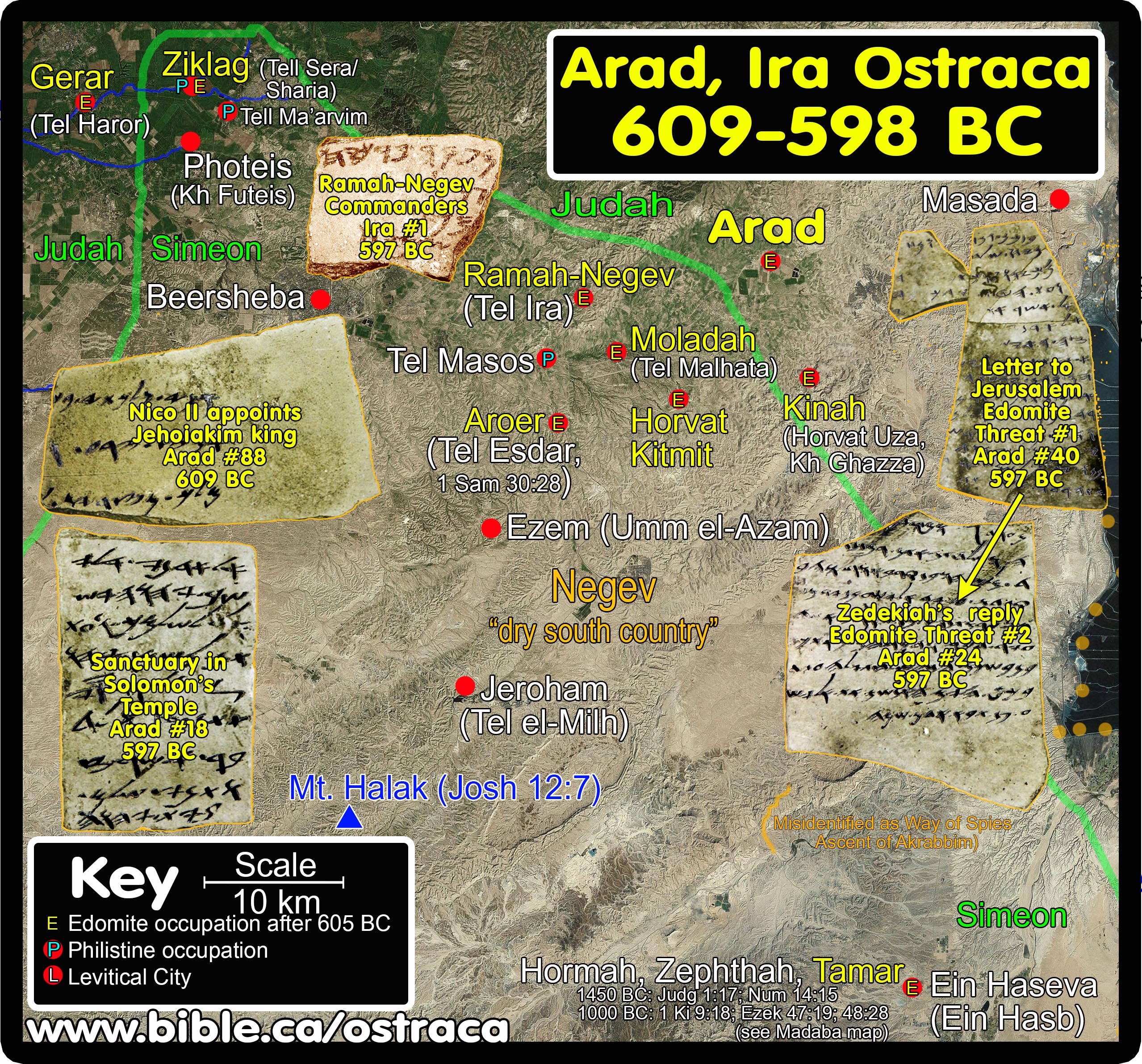
d. The fortress commander replied on Arad Ostracon #40 (Arad Ostracon #40 Letter to Zedekiah: "We won't send troops" 597 BC) It is a letter written on a broken pottery sherd from Gemariah to his father Malchijah at Arad that records the message that defied both his father Malchijah and King Zedekiah: "No, we will not send any of our troops to Ramah-Negev as directed by the king." The reason was because moving the troops out of Kinah to nearby Ramah-Negev would seriously endanger the security of Kinah itself against the Edomites! There were simply not enough troops to secure both Kinah AND Ramah-Negev.
e. King Zedekiah recorded his threatening response in a follow-up letter on another pottery sherd to Eliashib, the kings executive agent at the Arad fortress on Arad ostraca #24 (Arad Ostracon #24 Letter from Zedekiah: "Send troops or be executed" 597 BC). Zedekiah's follow-up letter to Eliashib on Arad ostraca #24 was simple: Send 50 soldiers from Arad and 100 from Kinah under the command of Malchijah from Arad, and deliver them to the command of Elisha, commander of the Ramah-Negev fortress that is under Edomite attack OR DIE.
f. In the end, we know from archeology that all four fortresses were lost to the Edomites by the time Nebuchadnezzar makes his third and final attack on Jerusalem in 587 BC when Solomon's temple was destroyed.
g. The Edomites assisted in destroying the city of Jerusalem and even looted the Temple itself. During the final 587 BC Babylonian attack on Judah many Jews fled for their lives and were captured and killed by the Edomites at the crossroads near the Arad, Kinah, Ramah Negev and Moladah fortresses. "To Edom: Do not stand at the fork of the road to cut down their fugitives; and do not imprison their survivors In the day of their distress." (Obadiah 10-14) Edom was condemned by God for its role in the destruction of Judah, Jerusalem and Solomon's temple in 587 BC and became an extinct nation by the time Judah returned from captivity in 536 BC. “To Edom: Like the overthrow of Sodom and Gomorrah with its neighbors,” says the Lord, “no one will live there, nor will a son of man reside in it." (Jeremiah 49:16-18)
h.
The archaeological record refutes the fiction that the border of Edom
was in the Negev near Ain el-Qudeirat at the time of the Exodus. This means
that the location of Kadesh Barnea on most Bible maps is wrong.
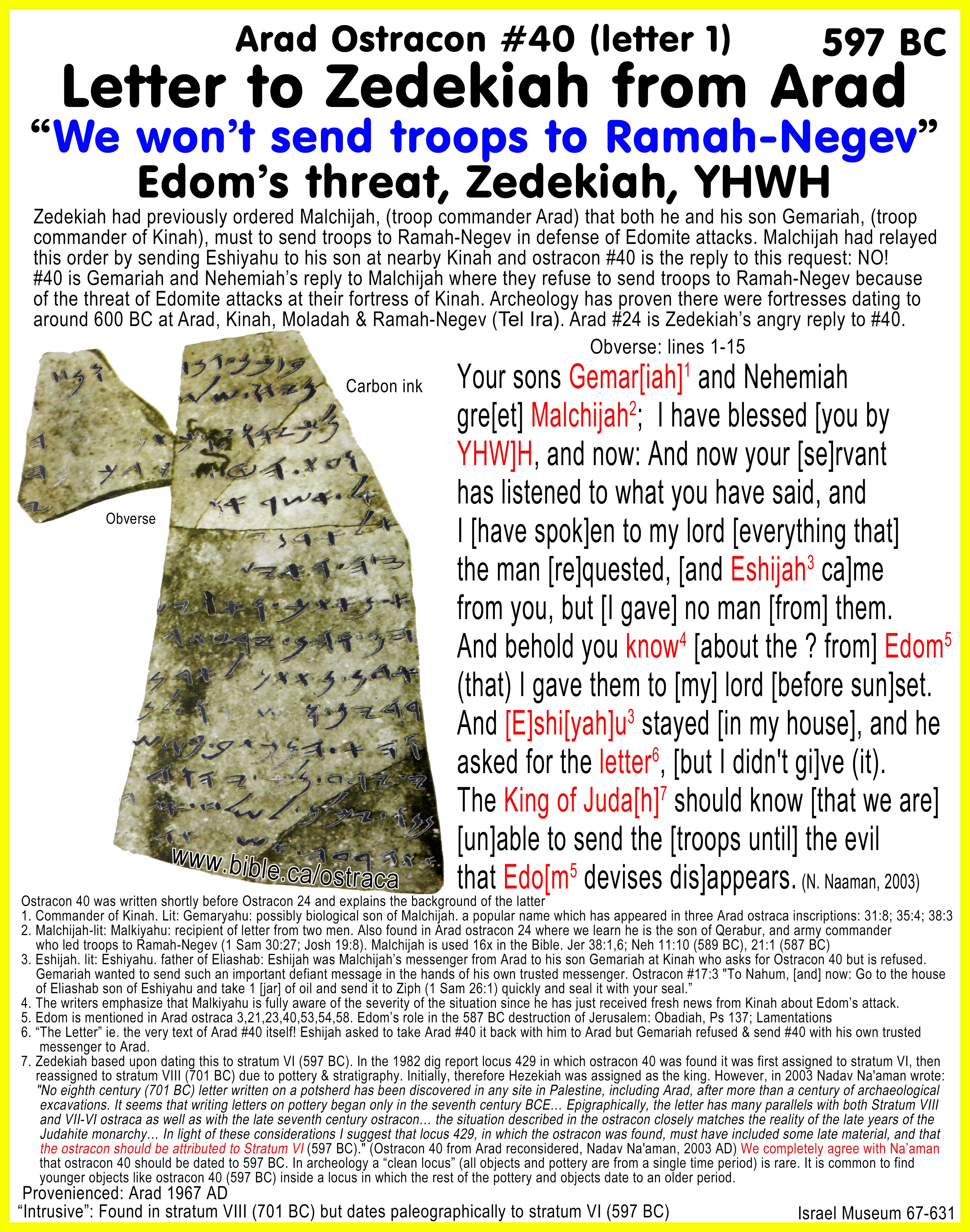
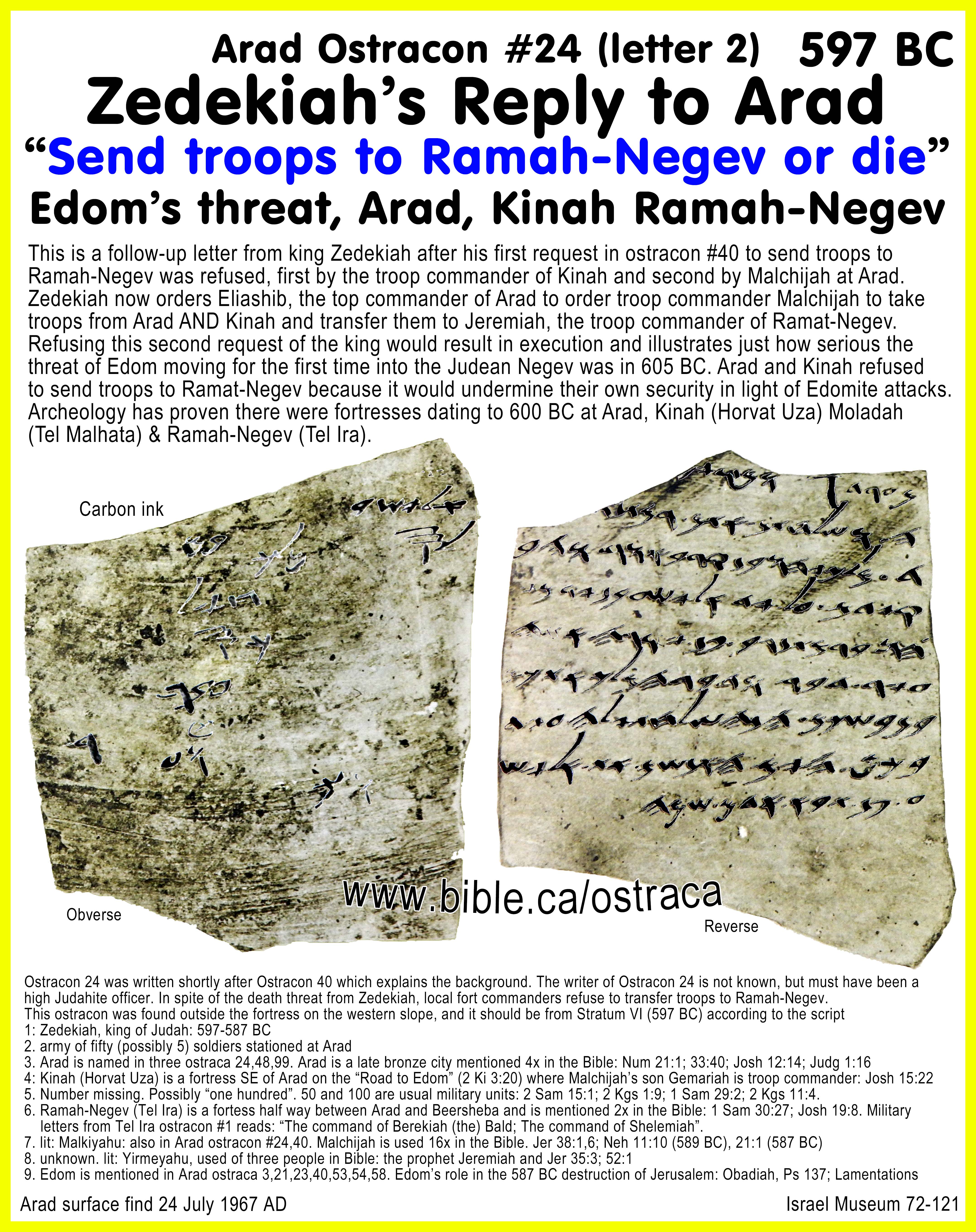
39. The Negev of Judah was bounded by the Salt Sea, the Gulf of Aqaba
and the Wadi El-Arish. Advocates of Kadesh Barnea at Qudeirat and others like Glen
Fritz whose site for Kadesh is 35 km east of Ein Hatseva (Hormah) are forced to
create the fiction that the “Biblical Negev” did not extend south of Arad and
Beersheba.
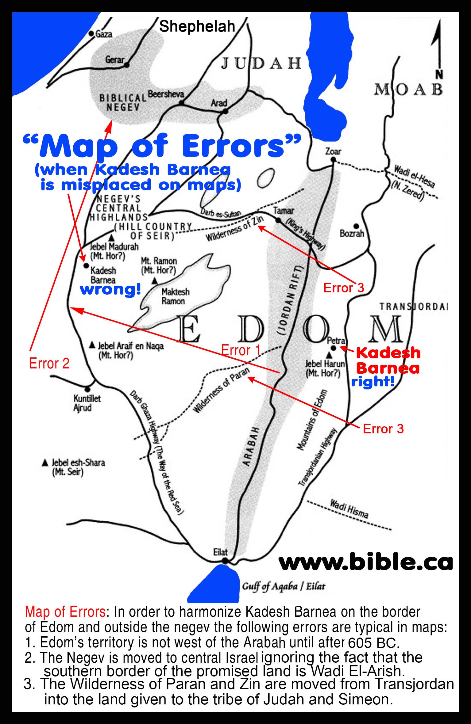
40. The Conquest began in 1406 BC and took 6 years. Then during
the first sabbatical year of 1399 BC they set up the tabernacle tent at Shiloh
where it stood for 305 years until 1094 BC. In 1094 BC, the Ark of the Covenant
was captured by the Philistines at Ebenezer then transported to 3 of the five
pentapolis cities of the Philistines: Ashdod, Gath and Ekron. The Philistines
sent the Ark back to Judah at Beth-Shemesh where the locals transported it to
Kirath-jearim where it sat for 92 years from 1093 to 1001 BC. David
successfully moved the Ark to Jerusalem in his second attempt in 1001 BC.
Meanwhile, in 1094 BC the Tabernacle tent was moved to Nob on the Mount of
Olives where it stood for 76 years from 1094-1018 BC. In 1018 BC Saul executed
all the priests and moved the Tabernacle tent to Gibeon where it stood for 58
years from 1018-960 BC. The Ark of the Covenant was moved into the Temple of
Solomon upon its completion in 960 BC and the tabernacle tent of Moses was
moved from Gibeon and put into storage inside the Temple, along with the Sea of
Moses.
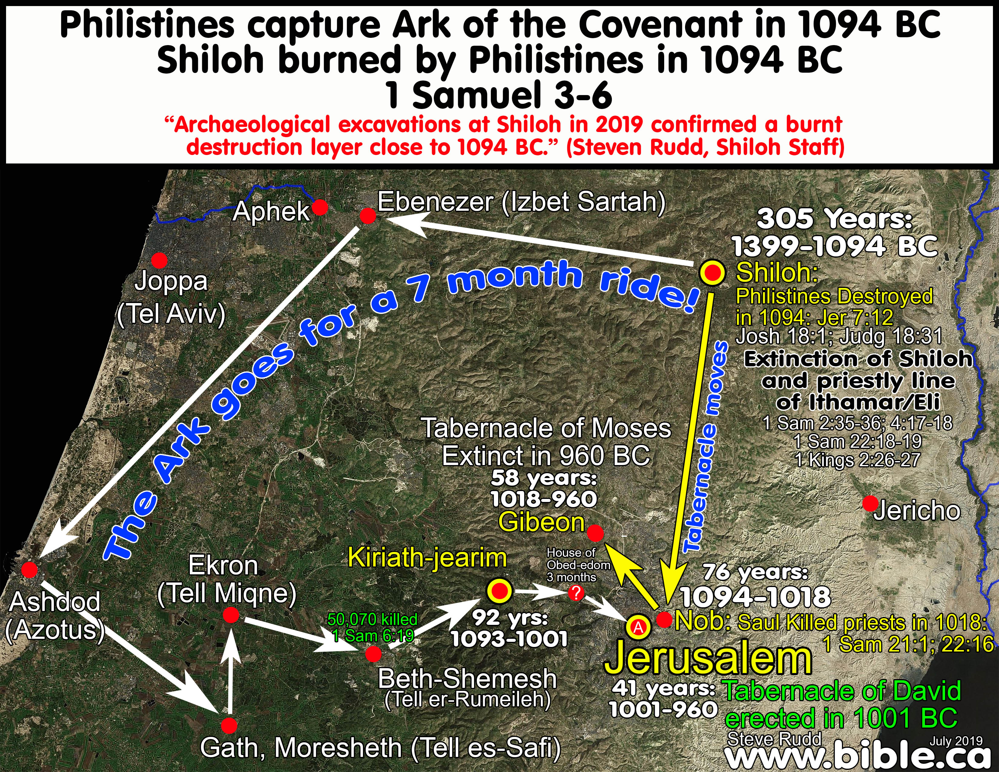
41. The archaeological evidence and ancient literary sources for Mt. Sinai in Saudi Arabia: There is no known archaeology in Saudi Arabia or anywhere near Mt. Lawz that coincides with the Late Bronze Age period of the exodus. Josephus gives us two clues to the location of Mt. Sinai. He says Mt. Sinai is the highest mountain in the area near the city of Midian (Al Bad). Virtually every proponent of the Nuweiba crossing makes false claims of archeological proofs of the exodus near or around Mt. Lawz and Mt. Maqla and it must stop to prevent further damage to the cause of Christ.
II. REJECTED: The Impossible Nuweiba Red Sea Crossing:

Introduction:
1. Master Summary of Glen Fritz Nuweiba Red Sea Crossing route to Mt. Lawz:
a.
Elephant in the room: What triggered Pharaoh to chase Moses?
Was Pharaoh “self-triggered” to overtake Moses at Etham or “God triggered”
at Etham to overtake Moses at the Red Sea? Glen Fritz has Pharaoh wake up on
day 4 and decide on his own to start pursuing the Hebrews, long before the
“wilderness has shut them in” at Etham. Pharaoh leaves Egypt on day 4 and
overtake Moses at Etham on day 14, with four more days before both reach the
Nuweiba beach on day 18. Pharaoh slowly walks behind the Hebrews for the next
four days until the pillar of cloud stops the army at the beach on day 18.
Scripture says God triggered Pharaoh to chase Moses after a messenger reported
Israel was trapped in the wilderness at Etham and Pharaoh overtook Israel at
the Red Sea.
Glen Fritz scenario:
Day 1: Moses leaves Egypt for Nuweiba.
Day 4: Pharaoh is self-triggered and begins chasing Moses.
Day 14: Moses arrives at Etham and God changes course to Nuweiba.
Day 14: Pharaoh overtakes Moses at Etham and determines Israel is “easy
prey” as they walk towards the canyons of the Wadi Watir.
Day 14: Pharaoh begins slowly and peacefully trailing Moses to the
Nuweiba beach without attacking.
Day 18: Moses and Pharaoh both arrive at Nuweiba the same day and Pharaoh
suddenly decides to attack but the pillar of fire intervenes. The sea is
divided that night.
Day 19-20: Moses crosses the Red Sea at Nuweiba.
Scripture: Triggered at Etham and overtaken at the Red Sea!
"Now the Lord spoke to Moses, saying, “Tell the sons of Israel to turn
back [retrace their steps] and camp before
Pi-hahiroth, between Migdol and the sea; you shall camp in front of
Baal-zephon, opposite it, by the sea. “For Pharaoh will
say of the sons of Israel, ‘They are wandering aimlessly in the land; the
wilderness has shut them in.’ “Thus I will harden Pharaoh’s heart, and he will
chase after them; and I will be honored through Pharaoh and all his
army, and the Egyptians will know that I am the Lord.” And they did so. When the king of Egypt was told that the people had fled [a message arrived from the Hebrew camp at the Red Sea],
Pharaoh and his servants had a change of heart toward the people, and they
said, “What is this we have done, that we have let Israel go from serving us?”
So he made his chariot ready and took his people with him; and he took six
hundred select chariots, and all the other chariots of Egypt with officers over
all of them. The Lord hardened the heart of Pharaoh, king of Egypt, and he chased after the sons of Israel as the sons of Israel
were going out boldly. Then the Egyptians chased after them with all the horses
and chariots of Pharaoh, his horsemen and his army, and they overtook them camping by the sea, beside Pi-hahiroth, in front
of Baal-zephon." (Exodus 14:1–9)
b. Chronologically impossible: The Nuweiba Red Sea crossing is chronologically impossible because Israel cannot reach the Wilderness of Sin by day 31. The underwater land bridge at Nuweiba is comparable in slopes to the Tiran crossing. The difficult canyon travel on either side of Nuweiba crossing make the route impossible, not the slope of the underwater land bridge.
c.
Time: Grand total of 64 days:
30 days from Goshen to Wilderness of Sin.
31 days form Wilderness of Sin to Wilderness of Sinai.
3 days to reach Mt. Sinai.
d.
Distance: Grand total of 555 miles/888 km:
Goshen to Nuweiba: 436 km
Red Sea crossing: 16 km
Wilderness of Shur to Mt. Sinai: 436 km
e. Equally split into two distances of 436 km: The distance of the route is split equally before and after the Red Sea crossing at 436 km. The difference is that it takes Moses 18 days to travel the first distance of 436 km from Goshen to the Red Sea, then 44 days to travel the second distance of 436 km to Mt. Sinai.
f. Conclusion: There are several serious deficiencies in Glen Fritz’s proposed Nuweiba Red Sea crossing route that demonstrate the Straits of Tiran route is the only workable crossing point on the Gulf of Aqaba which harmonizes with both scripture and topography.
2. Glen Fritz is a Doctor of Philosophy in Environmental Geography and is the only proponent of the Nuweiba crossing who has done serious, detailed and scholarly work to support this location for the Red Sea crossing. His Ph.D. Doctoral Dissertation in 2006 was called, “The Lost Sea of the Exodus”. He turned his PhD dissertation into a book of the same title in 2007 AD, then published the second edition of “Lost Sea of the Exodus” in 2016 AD. Fritz’s other book “The Exodus Mysteries” (2019 AD) focuses on the geography, geology and archaeology of north Saudi Arabia in support of Lawz being Sinai.
a. Fritz correctly admits no archaeological evidence dating to the time of Moses has been found in Saudi Arabia or anywhere near Mt. Lawz or Mt. Maqla. “Lacking datable Bronze Age inscriptions, adornments, and pottery, there is little concrete information” (Exodus Mysteries, Glen Fritz, p226, 2019 AD). The science of Fritz’s blunt denial of archaeological evidence contrasts with the plethora of lies and falsehoods that populate the internet at the hands of Unicorn Internet Archaeologists (UIA) like Ron Wyatt, Larry Williams, Bob Cornuke, David Fasold, Howard Blum, Larry Williams, Lennart Möller, Jim Caldwell, Penny Caldwell and Ryan Mauro, Andrew Jones, Joel Richardson. These are motivated by money and fame, and lack the serious detail and analysis of the Nuweiba route presented by Glen Fritz. They would be prudent to accept Fritz’s statement that no archaeological evidence has been found and withdraw their false claims to the contrary.
b. We have attempted to represent the itinerary of Glen Fritz honestly and faithfully from his various publications. If we have misrepresented some detail, it is not intentional. However, Fritz never created a unified chronology table, map of the entire route or summary table that lists dates, distances and day counts making it difficult for his readers to know what he is saying. We will correct any misrepresentations if we are notified.
c. In contrasting the Tiran and Nuweiba routes, the reader must decide which view is better supported by the evidence.
3. Glen Fritz published citations to ensure he has not been misrepresented:
a. “Via the theoretical route presented in this chapter, the distance from Rameses (Tell el-Dab’a) to the Nuweiba beachhead is 438 km (272 mi.). With a projected average daily pace of 25 km (15.5 mi.), the Hebrews could have reached this destination in about 18 days. The Egyptian army, traveling at an average daily pace of 32 km (20 mi.), could have reached this beachhead in 14 days [Rudd note: day 18, same day Moses arrived, and sea is divided that night]. Based on these hypothetical travel rates, Pharaoh would have had up to four days after the Hebrews departed Egypt to marshal his forces for pursuit. [Rudd note: Fritz has Pharaoh start chasing Pharaoh on day 4 and catching up to Moses at Etham on day 14.]” (Lost Sea of the Exodus, Glen Fritz, p234, 2016 AD)
b. “The route between Tell el-Dab’a (Rameses) and this Etham campsite was generally uphill, as shown in the elevation profile. If the Hebrews maintained the aforementioned pace of 25 km (15.5 mi.) per day, the 330 km (205 mi.) trek from Rameses would have required about 14 days [Rudd note: Fritz has Pharaoh leave Egypt day 4, catch up to the Hebrews on day 14 at Etham, then arrive at the Nuweiba beach on day 18 at the same time as Moses]. If the Egyptian army traveled at 32 km (20 mi.) per day, they could have reached the point of the Etham encampment in about 10 days. While at the Etham encampment, a divine command was given to turn and proceed to encamp by the sea (Exod. 14:2). [Rudd note: In Fritz’s bizarre scenario, Pharaoh had already caught up and overtaken the Hebrew camp at Etham on day 14. It took 4 days for Moses to navigate the 78 km of narrow canyons of the Wadi Watir which were filled the entire length with Hebrews walking in a long human column. Most of the Hebrews would need to camp two days waiting to enter the Wadi Watir canyons as the mass of humans are channeled through the narrow canyons to the Nuweiba beach. While the first Hebrews reached the Nuweiba beach on day 18, the last after a two-day camp at Etham, would not arrive until day 20. This directly contradicts scripture that says Pharaoh overtook Moses at the Red Sea.] This instruction was recalled in Num. 33:7. Both verses use the Hebrew verb “shuv”, meaning “to return” or “turn back” (Gesenius 1979, 7725), connoting a significant change of course, not just a slight veer. A southerly turn from the theorized Etham camp sends the route up into the broad upper reaches of Wadi Girafi. About 21 km (13 mi.) further south, the watershed division between Wadis Girafi and Watir lies at an elevation of 795 m (2600’), about 100 m (300’) above the Etham camp elevation. About 8 km (5 mi.) south of this divide, two wadis merge to form a funnel-like entrance to the Wadi Watir south from the Etham encampment, rising to reach the watershed divide between Wadi Girafi and Wadi Watir. The entrance to Wadi Watir is encountered about 8 km (5 mi.) south of the “divide.” This “opening” is about 29 km (18 mi.) south of the Etham camp, slightly more than a day’s journey.” (Lost Sea of the Exodus, Glen Fritz, p228, 2016 AD)
c. “Sometime after the turn at Etham, the Hebrews became “entangled in the land…shut in by the wilderness” (Exod. 14:3), leading Pharaoh to perceive that the Hebrews would be an easy prey. [Rudd note: Pharaoh’s army has arrived at Etham and stood idle beside the Hebrew camp at Etham on day 14 but concludes Israel is “easy prey” only after the Etham turn towards the Nuweiba beach. Pharaoh must slowly follow the 3 million Hebrews for 4 days through the narrow canyons of Wadi Watir until the protecting angel stops the army just before reaching the beach.] Moses’ reference to this scenario implies that someone in Pharaoh’s ranks was familiar with the terrain, although it was far-removed from Egypt. … The prospect of being entrapped by the wilderness easily applies to the confines of the Wadi Watir canyons, which terminate as a narrow gap west of the Nuweiba beachhead.” (Lost Sea of the Exodus, Glen Fritz, p229, 2016 AD)
d. “Based on the divine command given to Moses at Etham, to turn, and encamp before the sea (Exo. 14:1-2), this route funneled the Hebrews southward into the Wadi Watir with the Egyptian army in hot pursuit. [Rudd note: In Fritz’s scenario, Pharaoh was not “in hot pursuit” but camping 4 days beside the Hebrews and slowly trailing behind the last Hebrews walking through the Wadi Watir canyons to the Nuweiba beach arriving on day 18 at the same time as Moses.]” (Exodus Mysteries, Glen Fritz, p333, 2019 AD)
e. “The shorelines north and south of this beach are barely passable [Rudd note: The shorelines are as equally passable as the canyon travel before and after Nuweiba.] due to the mountain slopes that drop abruptly into the sea.” (Exodus Mysteries, Glen Fritz, p333, 2019 AD)
f. “Assuming that Yam Suph was crossed within 20 days of leaving Egypt (Fritz 2016a), about 10 days then remained to reach the Wilderness of Sin. I arbitrarily place the center of this wilderness (pictured in Figure 21.6) at 29 km (18 mi.) south of Al-Bad’. This point would have been 122 km (76 mi.) from the Arabian beachhead for that segment of the congregation that did not camp at Yam Suph. For those who went to Yam Suph, two 19-mile trips in Wadi Ḥamḍ would be added--about 61 km (38 mi.), giving them a total travel distance of 183 km (114 mi.). However, in Moses’ reckoning, the Wilderness of Sin likely began immediately south of Elim, which would decrease the listed mileage. Assuming three encampment days for each group leaves about seven travel days to cover these distances. Thus, the daily travel rates calculate to 17.5 km (10.9 mi.) and 26.25 km (16.3 mi.) respectively. However, the initial arrival of the multitude in the Wilderness of Sin likely preceded the hundreds of thousands trailing behind by several days [Rudd note: Fritz splits the Hebrews into two travel groups at Elim at Al Bad/Midian. The larger main group goes from Elim to the Wilderness of Sin while a smaller second group travel to the 2nd Red Sea camp at Maqnah, back to Elim then to the Wilderness of Sin, two days behind the first group all the way to Dophkah]. If such was the case, the travel pace for those who camped at Yam Suph would have been less than calculated above.” (Exodus Mysteries, Glen Fritz, p399, 2019 AD)
g. “The continuation to Yam Suph [Rudd note: 2nd Red Sea camp at Maqnah], 30.5 km (19 mi.) from the Al-Bad’ part of Elim, is a bit of a conundrum [Rudd note: it contradicts scripture] because it amounted to a significant deviation from the net course of the journey to Mount Sinai.” (Exodus Mysteries, Glen Fritz, p391, 2019 AD)
h. “The total distance between the entry into Rephidim at the Khuraitah pass and the arrival at the eastern base of Jabal al-Maqla is about 122 km (76 mi.). If the travel pace averaged 13 km (8 mi.) per day (merely an estimate), this journey would have required 9 days. This relatively slow pace would take into account the time required for the water provision at the rock in Horeb, and for the ensuing day-long battle with the Amalekites.” (Exodus Mysteries, Glen Fritz, p137, 2019 AD)
i. “Rephidim was a separate district from the Wilderness of Sinai, which hosted Mount Sinai. But the Wilderness of Sinai and Mount Sinai were both referenced as also being located in Horeb. Furthermore, Hebrew grammar and idiom usage do not support the idea that Horeb was a mountain. Moses’ use of Horeb to reference the Mount Sinai region is best explained as a part of speech called metonymy.” (Exodus Mysteries, Glen Fritz, p141, 2019 AD)
j. “The distance between the emergence from the sea and the base of Jabal al-Maqla was about 375 km (233 mi.) for those who did not encamp at Yam Suph. For those who made the side trip to Yam Suph, the distance was about 436 km (271 mi.) [Rudd note: Fritz splits the Hebrews into two travel groups at Elim at Al Bad/Midian. The larger main group goes from Elim to the Wilderness of Sin while smaller second group go to the 2nd Red Sea camp at Maqnah, back to Elim then to the Wilderness of Sin, two days behind the first group all the way to Dophkah]. This journey required about 43 days and consisted of three segments: about 10 days from the beachhead to the Wilderness of Sin, 30 days from the Wilderness of Sin to the entry into the Wilderness of Sinai (Exo 19:1), and 2-3 additional days to reach Mount Sinai via Wadi ar-Rayt. Without taking encampment stoppages into account, the daily travel rate averaged 8.7 km (5.4 mi.) and 10.1 km (6.3 mi.) respectively for the two groups. If 12 days are arbitrarily set aside for encampment activities, the remaining 31 travel days require an average daily pace of 12.1 km (7.5 mi.) and 14.1 (8.8 mi.) respectively [Rudd note: The Fritz route is a grand total of 64 days and 888 km (555 miles) from Goshen to Mt. Sinai but he never tells you this fact in plain language, in a single sentence, that the total trip took x days and was x miles long from Goshen to the foot of Mt. Sinai. Instead he obfuscates these numbers by embedding smaller units of time and distance, scattered all over the place, hundreds of pages apart, forcing the reader to manually add them up. For example, his total distance of 272 miles from Goshen to Nuweiba is on page 234 but his distance of 271 miles from Nuweiba to the foot of Mt. Sinai is found on page 471. He never tells the reader that adding these two numbers up creates a sum that doesn’t include the actual Red Sea crossing.]. The point here is that, despite the circuitous route to Mount Sinai, these rates are moderate and reasonable, and correspond to the time periods indicated by the Exodus itinerary.” (Exodus Mysteries, Glen Fritz, p471, 2019 AD)
4. Glen Fritz makes six critical chronological errors in his Nuweiba crossing exodus route.
a. First Chronological Error: Fritz misinterprets the chronological marker in Ex 19:1 as being at a geographic location that is 3 days short of the final camp spot at Mt. Sinai. Fritz marks 61 days from Goshen to the Wilderness of Sinai, then 2-3 more days to reach the final camp in front of Mt. Sinai on day 64. Scripture never says Israel camped in the Wilderness of Sinai then journeyed to the foot of Mt. Sinai. Instead scripture equates the Wilderness of Sinai as being equal to the final camp in front of Mt. Sinai. "In the third month after the sons of Israel had gone out of the land of Egypt, on that very day they came into the Wilderness of Sinai. When they set out from Rephidim, they came to the Wilderness of Sinai and camped in the wilderness; and there Israel camped in front of the mountain." (Exodus 19:1–2) In the Numbers 33 itinerary, the Wilderness of Sinai was the final camp spot for 11 months at Mt. Sinai: "They journeyed from Rephidim and camped in the Wilderness of Sinai. [11 months, 5 days pass] They journeyed from the Wilderness of Sinai and camped at Kibroth-hattaavah." (Numbers 33:15–16) It is unclear why Fritz would fabricate an extra stop at the Wilderness of Sinai before reaching Mt. Sinai in his itinerary which is not found in scripture. At 888 km, the Fritz Nuweiba route is so long, perhaps he knew he needed the additional 2-3 days to reach Sinai by day 64 at the earliest.
b. Second Chronological Error: Fritz miscalculates the journey as 61 days instead of the correct 47 days as per Ex 19:1. "In the third month after the sons of Israel had gone out of the land of Egypt, on that very day they came into the Wilderness of Sinai." (Exodus 19:1–2) It is 47 days from Nisan 15 to Sivan 1, but Fritz misinterprets it as a 61-day journey from Nisan 15 to Sivan 15. Ex 19:1 speaks of the first sighting of the new moon marking the first day of the third month, not the 15th day of the third month. All ancient literary sources, including Josephus, are unanimous in confirming a 47-day period from Goshen to Sinai. See: Travel times, distances, days of the week
c. Third Chronological Error: Fritz ignores the 8-day camp on the Nuweiba beach waiting for Pharaoh on days 18-25. Although Fritz is correct that Israel arrived at the Nuweiba beach on day 18, he has Israel cross the Red Sea on day 19. Fitz not only ignored the time (5 days minimum on horseback) it would take for a messenger to be sent to Egypt after Etham (Day 15 at the earliest), he also ignores the time (minimum 7 days) for Pharaoh to read the message and travel to the Nuweiba beach on his horse drawn chariot. In Fritz’s flawed formulation, Israel has already left the Wilderness of Sin about the time Pharaoh arrives at the Nuweiba beach. To solve this huge problem, Fritz has Pharaoh begin chasing the Hebrews on day 4 from Egypt, which is 10 days before Fritz has Israel “trapped in the wilderness” on day 14 at Etham.
d. Fourth Chronological Error: Fritz has Israel arriving at the Wilderness of Sin on day 30 after leaving Goshen, apparently unaware that Nisan 15 to Iyar 15 calculates to 31 days in a standard 30-day lunar calendar. According to Ex 16:1, Israel arrived in the Wilderness of Sin on day 31 from Goshen. A 30-day Hebrew month is confirmed by Josephus in Antiquities 2.316 when he says Israel had 30 days of food, meaning they ran out on the 31st day when they entered the Wilderness of Sin. It is also possible to have up to 4 consecutive 30-day lunar months. Although Fritz transposed the two numbers 30 and 31, his route is still 61 days total, but it is 31 days from Goshen to the Wilderness of Sin in Ex 16:1 (Nisan 15 to Iyar 15) and 30 days more to the Wilderness of Sinai (Iyar 16 to Sivan 15).
e. Fifth Chronological Error: Fritz ignores the 8-day camp at the Wilderness of Sin as a vehicle to learn the Sabbath/Manna cycle. He has Israel leave the day after they arrive on day 31. Ex 17:1 says that Israel did not leave the Wilderness of Sin until after the 6 days of manna (Sunday to Friday) and first sabbath day. The 3 million Hebrews arrived on a Saturday as one group, listened to Moses’ instructions, camped 8 nights and left Sunday morning for Dophkah.
f. Sixth Chronological Error: Fritz crosses the Red Sea too early on day 18 instead of day 25. Israel arrived at the Wilderness of Sin on day 31 (Ex 16:1). Israel crossed the Red Sea on day 25 then traveled three days to reach Marah on days 26-28 (Ex 15:22–23), then traveled to Elim on day 29, then traveled to the second Red Sea camp on day 30, then arrived at the Wilderness of Sin on day 31.
A. The Glen Fritz exodus route itinerary chart of chronology and distances:
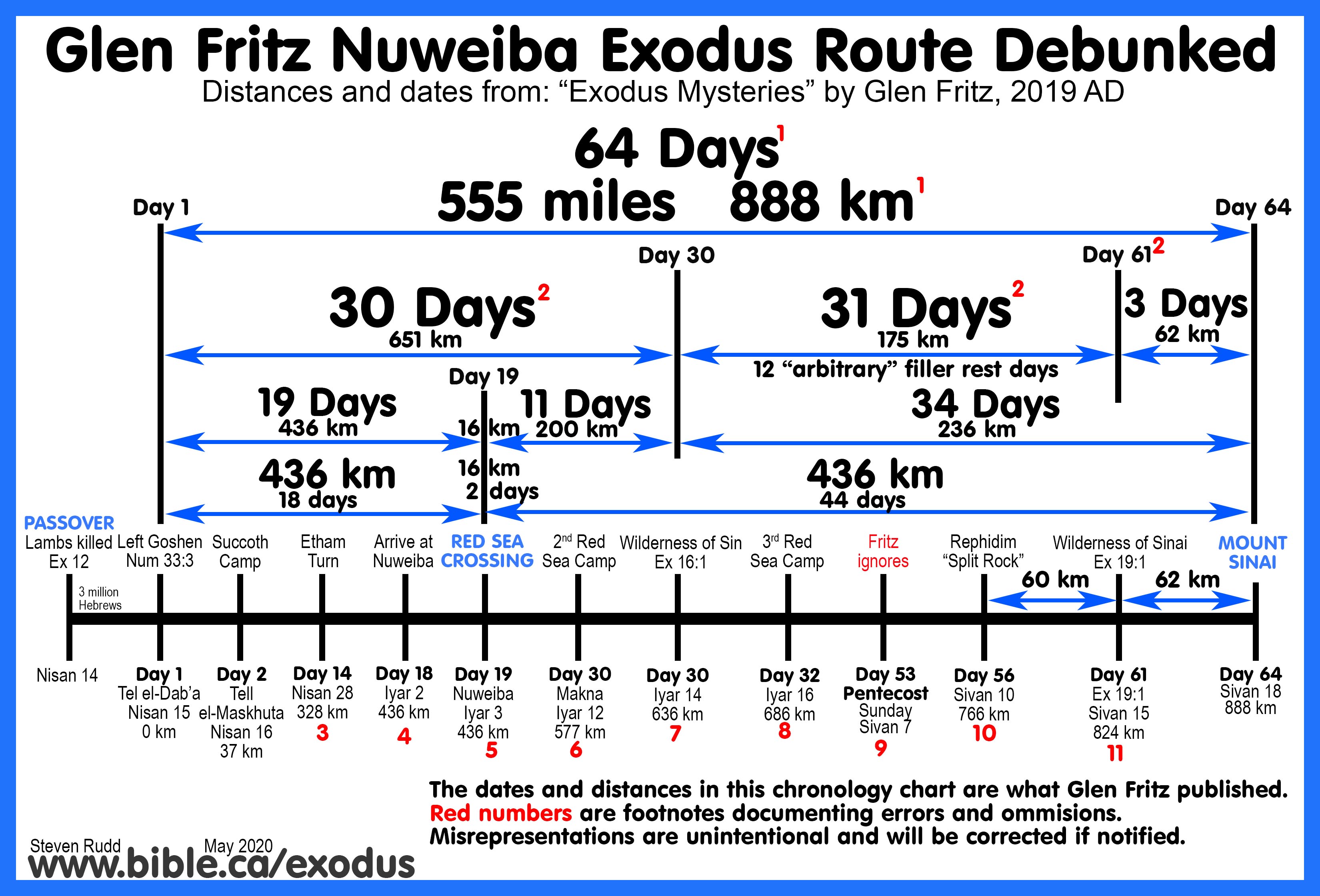
Footnotes from above chronological chart of Glen Fritz:
1. Footnote #1: The Fritz route is a grand total of 64 days and 888 km (555 miles) from Goshen to Mt. Sinai. Fritz has Israel arriving in the Wilderness of Sinai on day 61 but there are still 3 days of travel to reach the final camp at the foot of Mt. Sinai on day 64. To the contrary, scripture demonstrates that arriving in the Wilderness of Sinai is identical to arriving at the final camp in front of Mt. Sinai as per Ex 19:1. The Glen Fritz route is 436 km from Goshen to Nuweiba, 16 km crossing the Red Sea and another 436 km to Mt. Sinai including the 2nd Red Sea camp at Maqnah. The Rudd route through the Straits of Tiran is a grand total of 700 km from Goshen to Sinai. It is 500 km from Goshen to the Tiran, including the 16 km Red Sea crossing, then another 200 km to Mt. Sinai. Fritz never tells you his route is a grand total of 64 days and 888 km (555 miles) in plain language in a single sentence. He never tells his readers the trip is a total of 64 days. Instead he obfuscates these numbers by embedding smaller units of time and distance, scattered all over the place, hundreds of pages apart, forcing the reader to manually add them up. For example, his total distance of 272 miles from Goshen to Nuweiba is on page 234 but his distance of 271 miles from Nuweiba to the foot of Mt. Sinai is found on page 471. He never tells the reader that adding these two numbers up creates a sum that does not include the actual Red Sea crossing. Fritz failure to provide an overall summary calendar with locations, times, and distances, made it frustratingly complicated for the average reader to understand his route.
2. Footnote #2: Ex 19:1 is 47 days from Nisan 15 to Sivan 1, but Fritz misinterprets it as a 61-day journey ending on Sivan 15. In Ex 16:1 Fritz also miscalculated Nisan 15 to Iyar 15 as 30 days instead of the correct 31 days. A 30-day Hebrew month is confirmed by Josephus in Antiquities 2.316 when he says Israel had 30 days of food, meaning they ran out on the 31st day when they entered the Wilderness of Sin. It is also possible to have up to 4 consecutive 30-day lunar months. Although Fritz transposed the two numbers 30 and 31, his route is still 61 days but it is 31 days from Goshen to the Wilderness of Sin in Ex 16:1 (Nisan 15 to Iyar 15) and 30 days more to the Wilderness of Sinai in Ex 19:1 (Iyar 16 to Sivan 15). Fritz miscalculates his misinterpretation!
3. Footnote #3: The Nuweiba route’s location for Etham is a right hand turn instead of a full reverse backtrack as the Hebrew word normally means. The earliest a messenger could be sent to Pharaoh is three days after Etham on day 17. Fritz ignores the time it takes to send a message 328 km back to Egypt to inform Pharaoh that Israel is trapped. Such a journey which would take at least 5 days on horseback. Fritz’s training as a geographer leads him to misdefining “migdol” as a mountain range instead of an archaeological Egyptian military watchtower on the Gulf of Aqaba. This error eliminates the possibility of using messenger pigeons to get a message from the fortress to Pharaoh in 4 hours.
4. Footnote #4: It takes three days to walk through the 78 km of canyons in the Wadi Watir to reach the Nuweiba beach. The first group entered the canyons on day 15 and arrived at Nuweiba on day 18 while others camped two full days waiting for their chance to enter the canyons. The last of the Hebrews would enter the canyons on day 18 and would arrive at Nuweiba on day 20. Fritz has the Egyptian army arriving at Nuweiba on day 18 before the last of the Hebrews have fully transited the Wadi Watir on day 20.
5. Footnote #5: Fritz allows no camp days at Nuweiba for Pharaoh to travel 436 km from Egypt to Nuweiba and has Israel cross the morning after Pharaoh arrives. Fritz has Pharaoh leave Egypt on day 4, overtaking Moses at Etham on day 14 and arriving behind the last of the Hebrews at Nuweiba on day 18. Pharaoh would ride past all the Hebrews still walking through the Wadi Watir canyons only to be stopped by the pillar of cloud (Exodus 14:19) at the beachhead. In Fritz’s flawed itinerary, the protecting angel stood between Moses at the beach, and over 1 million Hebrews on the other side still travelling through the Wadi Watir canyons at the end of which was Pharaoh’s army. Apparently, 1/3 of the Hebrews and Pharaoh’s army waited together peacefully and patiently for two days before they all crossed the Red Sea together on day 20 after the protecting angel allowed them.
6. Footnote #6: Fritz splits the Hebrews into two groups at his location for Elim at Midian (Al Bad). The larger main group of Hebrews bypassed the second Red Sea camp altogether and headed straight for the Wilderness of Sin, arriving on day 30. A smaller group of Hebrews traveled 32 km from Midian to Maqnah on the Gulf of Aqaba then “backtracked” 32 km to Midian (Elim) arriving at the Wilderness of Sin on day 32. In both cases the itinerary contradicts the Bible and it adds two travel days to the route for those who camped at the Red Sea as Moses said they did. This is Fritz’s solution to getting Israel to the Wilderness of Sin by day 30 (corrected to day 31) and satisfying the Bible requirement of a second Red Sea camp before the Wilderness of Sin (Num 33:10). Those who went to the second Red Sea camp are two days behind those who went directly to the Wilderness of Sin and they miss Moses’ instructions about the Manna/Sabbath cycle in Ex 16:1. This violates scripture that says “all the congregation entered the Wilderness of Sin” together on the same day. In fact, because Fritz allows only one camp day at the Wilderness of Sin, those who arrived first and heard Moses instructions about the Manna/Sabbath cycle left two days before the second group arrive at the Wilderness of Sin. For the second group, Manna fell mysteriously and without explanation while they were camped at Maqnah beside the Red Sea. When the manna first fell for them at Maqnah and they asked, “what is it?”, Moses was 61 km away and two days ahead of them.
7. Footnote #7: Fritz has Israel arrive 1 day earlier at the Wilderness of Sin (day 30) than the Bible says (day 31). Nisan 15 to Iyar 15 is 31 days in a standard 30-day lunar calendar. He also has one group of Hebrews arriving at the Wilderness of Sin on day 30 and a second group who detoured to Maqnah arriving on day 32. Fritz’s location for the Wilderness of Sin is at the same place as Marah according to the Straits of Tiran route. The difference is the day count where the two routes merge and intersect. Day 31 for the Fritz/Nuweiba route at the Wilderness of Sin is the same location as day 28 for the Rudd/Tiran route at Marah. Fritz completely misses the fact that Israel camped 8 days in the Wilderness, of Sin learning the Manna/Sabbath cycle and departed for Dophkah only after the first sabbath and 6 days of manna: Ex 17:1. Fritz allowed no time (minimum 5 days) for a messenger to travel to Egypt from Etham to report to Pharaoh that Israel was trapped by the wilderness. Since the messenger on horseback left on day 17 to make the 5-day journey to Egypt, it translates into 4 camp days for Moses at Nuweiba. Fritz calculated it would take 14 days for Pharaoh to arrive at the Red Sea (we say 7). Fritz missed a total of 23 camp days in his itinerary up to the point that Moses left the Wilderness of Sin (4 + 14 + 1 + 8 =27). If we add these missed camp days directly on top of Fritz’s itinerary then Moses arrived at the Wilderness of Sin on day 49 (30 + 4 + 14 + 1 = 49) which contradicts Ex 16:1 that Moses arrived on day 31. Adding the 8 camp days Fritz missed at the Wilderness of Sin, to learn the Sabbath/Manna cycle means Moses left for Dophkah on day 57 (49 + 8 = 57), with a whopping 237 km of travel to reach Mt. Sinai by his day 64. This is impossible given the 5-day camp at Rephidim.
8. Footnote #8: Fritz’s Nuweiba route fabricates an unbiblical 3rd Red Sea camp on his day 32 at the same location where the Tiran route locates the Biblical 2nd Red Sea Camp on day 30. The two routes intersected at Marah and separate after the Biblical second Red Sea camp of the Tiran route. This leads us to wonder why God would go to all the trouble of the Nuweiba crossing if the Tiran crossing is faster, easier and the two routes merge after the Red Sea crossing anyway. Perhaps those who advocate the Nuweiba route should consider adopting the Tiran route instead.
9. Footnote #9: Fritz completely ignores the historic messianic synchronism between God giving both the Old and New Testament laws on Pentecost as unanimously witnessed in all the earliest Jewish and Christian literary sources as early as 150 BC.
10. Footnote #10: Fritz puts the “split rock” 122 km from the final Israeli camp at the foot of Mt. Horeb making it useless as a water supply for their 11-month long stay unless they hauled water 244 km round trip. Misunderstanding the text, Fritz misdefined Horeb as a wilderness instead of mountain. In fact, Rephidim was where the people grumbled for water, but Mt. Horeb is where Moses struck the rock 5 days later when he arrived at Mt. Sinai (Ex 17:6) on day 47. With this massive water supply in operation at the Hebrew camp at Mt. Sinai, Moses instructs them to wash their clothing 4 days later on Friday, called “preparation day” (day 51). The Hebrews were to be ready three days later on Pentecost Sunday (day 53) when God would give the Law.
11. Footnote #11: Fritz rejects that Exodus 19:1 is the final chronological marker of the journey when Israel arrived at the final camp at the foot of Mt. Sinai. Instead he views their arrival in the Wilderness of Sinai in Exodus 19:1 as 2-3 days and 62 km short of when Moses reaches the final camp at Mt. Sinai. When Fritz added the extra three days on top of Ex 19:1 it did not change the overall distance of 888 km from Goshen to Sinai but it allowed him to sneak in 3 extra travel days because his Nuweiba route takes 64 days and is 188 km longer than the Tiran route which is easily reaches Mt. Sinai in 47 days.
B. Correcting the errors and omissions of the Fritz Route itinerary
1. This is a side by side comparison of the Fritz itinerary and our corrections.
a. We checked Fritz’s distance calculations and they are basically correct.
b. In order to do an apples-to-apples comparison with the Nuweiba route, we applied the same rates of travel and camp days used in the Straits of Tiran route to Fritz’s route.
2. The conclusion is that the Glen Fritz Nuweiba Red Sea crossing route to Mt. Lawz/Maqla is impossible because Moses cannot reach the Wilderness of Sin by day 31 (Ex 16:1).
a. Although we agree with Fritz that Moses arrived at the foot of Mt. Sinai on day 64, the earliest Moses could arrive at the Wilderness of Sin was on day 39. FAIL
b. The Tiran route completes the same journey arriving at the Wilderness of Sin on day 31 and Mt. Sinai on day 47.
|
Glen Fritz Errors and Omissions Nuweiba Red Sea Crossing Deficiencies of the Glen Fritz Exodus Route using his distances but correcting his day count. |
|||||
|
Nuweiba Crossing |
Fritz Distance |
Fritz Days |
Fritz Day count |
Rudd Corrected day count |
Fritz errors and omissions |
|
Goshen to Etham |
328 km |
14 days |
1-14 |
1-14 |
Correct day count |
|
Etham to Nuweiba |
108 km |
4 |
15-18 |
15-18 |
Correct day count but it took 2 more days for those travelling in stages through the canyons to arrive on day 20 |
|
Camped at Red Sea |
- |
0 |
18 |
18-29 |
Fritz missed 11 camp days at the Nuweiba beach. 5 days to get message to Pharaoh on horseback on day 17 and 7 days waiting for Pharaoh to arrive. This allows the 2-day procession of canyon travelers to all arrive at the Red Sea. |
|
Red Sea Crossing |
16 km |
2 |
19-20 |
30 |
Fritz allowed 2 days for crossing, corrected to 1 day |
|
Wilderness of Shur to Wilderness of Sin |
186 km |
10 |
20-30 |
31-39 |
Shur to Marah: 3 days Marah to Elim: 3 days 2nd Red Sea camp: 2 days Wilderness of Sin: 1 day Total: 9 days |
|
Arrive at Wilderness of Sin |
- |
0 |
30 |
39 |
Ex 16:1 = Nisan 15 to Iyar 15 is 31 days. 8-day camp Saturday to 1st Sabbath day 45 |
|
Leave Wilderness of Sin |
- |
0 |
31 |
46 |
Moses leaves Sunday morning day 46 for 3rd Red Sea camp |
|
Wilderness of Sin to Wilderness of Sinai |
175 km |
30 |
31-61 Fritz’s 30 days is far too slow. |
46-61 |
3rd Red Sea camp: 2 days Arrive at 3rd Red Sea camp day 47. Dophkah: 1 day (arrive day 48) Leave Dophkah day 49 canyon travel to Alush: 3 days Arrive Alush day 51. Day 52: 2nd Sabbath day: 1 camp day at Alush. Leave day 53 from Alush to Rephidim: 1 day 5 camp days at Rephidim 60 km to Wild. of Sinai: 3 days Total: 16 days |
|
Rephidim to Mt. Sinai |
122 km |
9 |
55-64 |
54-64 |
5-day camp at Rephidim. 5 days to Mt. Sinai. Total: 10 days |
|
Wilderness of Sinai to Mt. Sinai: |
62 km |
2-3 |
Day 62-64 |
64 |
Although Israel arrives on day 64, the route is impossible because Moses arrived at the Wilderness of Sin after day 31 (Ex 16:1). |
C. The Glen Fritz exodus route terrain difficulty heuristic (TDH)
1.
TDH #1: Goshen to Nuweiba terrain difficulty heuristic:
Apples to apples comparison by applying the Tiran travel rates and camp
days to the Nuweiba route to see if it is a viable route able to reach Mt.
Sinai by day 47 as Ex 19:1 says.
|
Glen Fritz Nuweiba Red Sea Crossing to Lawz Goshen to Nuweiba Terrain Travel Difficulty and Day Count Heuristic |
||||||
|
Nuweiba Crossing |
Easy |
Challenging |
difficult |
Days |
Day count |
Daily Rate |
|
Goshen to Sinai Peninsula plateau |
80 miles 128 km |
|
|
4 |
1-4 |
20 m/d 32 km/d |
|
Sinai plateau to Etham |
|
125 miles 200 km |
|
10 |
5-14 |
13 m/d 20 km/d |
|
Sinai plateau, past Etham to Wadi Watir canyons |
|
147 miles 235 km |
|
11 |
5-15 |
13 m/d 21 km/d |
|
Etham to Nuweiba 67 miles, 107 km |
18 miles 29 km |
|
49 miles 78 km |
4 |
14-18 |
- |
|
Etham to Wadi Watir canyons entrance |
18 miles 30 km |
|
|
1 |
15 |
18 m/d 30 km/d |
|
First to enter Wadi Watir canyons to Nuweiba. |
|
49 miles 78 km |
3 |
16-18 First to arrive waited 2 days (19-20) for last to arrive. |
15 m/d 26 km/d |
|
|
Message to Pharaoh Entering the Wadi Watir on Day 16, day 17 is the earliest possible day a message would be sent back to Pharaoh on horseback. |
227 miles 328 km |
|
|
5 (Fritz totally ignored the messenger, Rudd added 5 days) |
17-21 |
45 m/d 65 km/d |
|
Last to enter Wadi Watir (150 m wide) and arrive at Nuweiba. The entire length of the 45-mile canyon was full of walking humans. |
|
|
49 miles 78 km |
3
|
19-20 The last men waited 2 days before entering the canyon before travelling 2 more days (19-20) to Nuweiba. |
78 km x 150 m = 11 km2 or an area of 3.3 km x 3.3 km area to fit 3 million Hebrews and their flocks. |
|
Waiting for Pharaoh Fritz said it would take 10 days for Pharaoh to travel from Egypt to Nuweiba but then allowed zero days in his itinerary. we allowed 7. |
272 miles 436 km |
|
|
7 |
21-29 |
37 m/d 62 km/d Tiran rate of travel was 58 km/d |
|
Pharaoh arrives at Nuweiba. The angel protects, sea parted overnight, Israel crossed next day. |
|
|
|
- |
29 |
|
|
Red Sea Crossing Fritz crosses on day 19-20 |
|
10 miles 16 km |
|
1 |
30 |
10 m/d 16 km/d |
|
TOTAL FAILURE OF THE GLEN FRITZ NUWEIBA EXODUS ROUTE ITINERARY The Nuweiba exodus route is impossible because Israel crosses the Red Sea on day 30 when Ex 16:1 says they must be in Wilderness of Sin on day 31 |
||||||
2.
TDH #2: Wilderness of Shur to Wilderness of Sin terrain difficulty
heuristic:
After the first total failure, Rudd graciously
reset the day count for crossing the Red Sea at Nuweiba to day 25 for an equal
comparison with the Tiran crossing on day 25 and using Fritz’s distances but
Rudd’s rate of travel in order to see if Fritz’s route is viable by entering
the Wilderness of Sin on day 31.
|
Terrain Travel Difficulty and Day Count Heuristic: Shur to Wilderness of Sin |
||||||
|
Nuweiba Crossing |
Easy |
Challenging |
difficult |
Days |
Day count |
Daily Rate |
|
3 days in Wilderness of Shur, canyons |
|
|
17 miles 27 km |
3 |
25-27 |
6 m/d 9 km/d |
|
Marah and Elim canyons |
|
|
41 miles 66 km |
3 |
28-30 |
14 m/d 22 km/d |
|
Backtrack to Red Sea & back to Elim |
|
10 miles 16 km |
30 miles 48 km |
2 |
31-32 |
20 m/d 24 km/d |
|
Arrive at Wilderness of Sin on Saturday |
18 miles 29 km |
|
1 |
33 |
18 m/d 29 km/d |
|
|
SECOND TOTAL FAILURE OF THE GLEN FRITZ NUWEIBA EXODUS ROUTE ITINERARY The Nuweiba is impossible because even after graciously resetting the day count for crossing the Red Sea from day 30 to day 25, Israel arrives in the Wilderness of Sin on day 33: Ex 16:1. The reason is the very slow canyon travel almost the entire route after crossing the Red Sea. The backtrack from the second Red Sea camp at Maqnah to Elim (Midian) also adds an extra day (Num 33:10). To fix this, Fritz splits the 3 million Hebrews into two groups so that first group skips the second Red Sea camp but gets to the Wilderness of Sin on day 30 (corrected to day 31), two days before the second group arrives on day 32 (corrected to day 33). By the time second group who actually went to the second Red Sea camp arrives at the Wilderness of Sin, the first group has moved on and is two days and 50 km ahead at Fritz’s unbiblical third Red Sea camp. |
||||||
3.
TDH #3: Wilderness of Sin to Mt. Sinai terrain difficulty heuristic:
After the second total failure of the Fritz
route, Rudd graciously reset the day count for arriving at the Wilderness of
Sin for the Red Sea crossing at Nuweiba to day 31 for an equal comparison with
the Tiran route. Again, we are using Fritz’s distances but Rudd’s rate of
travel and the 8 camp days at the Wilderness of Sin and 5 days at Rephidim
included in the Tiran route to keep the comparison apples to apples. The goal
is to see if Fritz’s route is viable by reaching Mt. Sinai on day 47.
|
Terrain Travel Difficulty and Day Count Heuristic: Wilderness of Sin to Mt. Sinai |
||||||
|
Nuweiba Crossing |
Easy |
Challenging |
difficult |
Days |
Day count |
Daily Rate |
|
Wilderness of Sin Sunday to 1st Sabbath |
|
|
|
8 |
31-38 Sabbath, manna cycle |
0 |
|
First sabbath |
|
|
|
38 |
0 |
|
|
Leave Wilderness of Sin to third Red Sea camp on Sunday |
32 miles 50 km |
|
|
2 |
39-40 |
16 m/d 25 km/d |
|
Third Red Sea camp to Dophkah |
15 miles 24 km |
|
|
1 |
41 |
15 m/d 24 km/d |
|
Dophkah to Alush Canyon travel |
|
15 miles 24 km |
1 |
42 |
15 m/d 24 km/d |
|
|
Alush to Rephidim Canyon travel Israel grumbles for water |
|
|
19 miles 30 km |
2 |
43-44 |
10 m/d 15 km/d |
|
2nd Sabbath at Rephidim while Amalekites attack |
|
|
1 |
45 |
0 |
|
|
Rephidim battle while Moses’ hands held high |
|
|
War day on Sunday |
1 |
46 |
0 |
|
Moses Judges at Rephidim all day while Jethro watches |
|
|
Moses Judges, Jethro’s Advice |
1 |
47 |
0 |
|
Rephidim to Wilderness of Sinai |
37 miles 60 km |
|
2 |
48-49 |
19 m/d 30 km/d |
|
|
Wilderness of Sinai to Mt. Sinai |
39 miles 62 km |
|
3 |
50-52 |
13 m/d 21 km/d |
|
|
Arrive at Sinai |
|
|
|
52 Days |
Day 52 |
|
|
THIRD TOTAL FAILURE OF THE GLEN FRITZ NUWEIBA EXODUS ROUTE ITINERARY Even after resetting the day count a second time, so that Israel arrives at the Wilderness of Sin on day 31, the Nuweiba exodus route is impossible because the earliest Israel can possibly arrive at Mt Sinai is day 52, which is 5 days after day 47 as per Ex 19:1. Without resetting the day count as we did twice, the Nuweiba route actually takes a full 64 days. This includes the same number of camp days as the Tiran route. |
||||||
4. Master
summary of Glen Fritz Nuweiba route terrain difficulty heuristic: 64-day route
In our “apples to apples” comparison of his Nuweiba route to our Tiran
route, we agree with Glen Fritz that Moses arrives at Mt. Sinai on day 64,
using the identical number of camp days as the Tiran route. As a Ph.D.
Geographer, Glen Fritz knew his route could not arrive at Sinai in 47-days, so
he was forced to misinterpret Ex 19:1 to say the journey was 61 days rather
than 47 days. Fritz also knew his route could not arrive at Mt. Sinai by day
61, so he fabricated a new unbiblical stop at the Wilderness of Sinai which,
instead of being at the foot of Mt. Sinai, was 30 km away from the base of the
Mt. Sinai. This allowed him to completely ignore his misinterpretation of Ex
19:1 being a 61-day journey to Mt. Sinai and extent the total number of days to
64 by sneaking in another 2-3 days between the Wilderness of Sin and Mt. Sinai
(Lost Sea of the Exodus, Fritz, p 471). However, it is impossible for Moses to
reach the Wilderness of Sin by day 31 under any scenario which falsifies his
entire Ph.D. thesis on the Nuweiba Red Sea crossing.
|
Summary of Fritz Nuweiba Route terrain difficulty heuristic (TDH) |
||||
|
Nuweiba Crossing |
Easy |
Challenging |
difficult |
Distance |
|
Goshen to Nuweiba |
98 miles 158 km |
125 miles 200 km |
49 miles 78 km |
272 miles 436 km |
|
Red Sea Crossing |
|
10 miles 16 km |
|
10 miles 16 km |
|
Nuweiba to Mt. Sinai |
141 miles 225 km |
10 miles 16 km |
122 miles 195 km |
273 miles 436 km |
|
Goshen to Mt. Sinai |
239 miles 383 km |
145 miles 232 km |
171 miles 273 km |
555 miles 888 km |
5. Tiran vs. Nuweiba route comparison: terrain difficulty heuristic:
|
Terrain Difficulty Heuristic (TDH) Comparison of Tiran vs. Nuweiba Red Sea Crossings |
||
|
|
Tiran: Rudd |
Nuweiba: Fritz |
|
Goshen to Sinai |
47 days 420 miles/700 km |
64 days 555 miles/888 km |
|
Goshen to Red Sea |
294 miles/490 km |
272 miles/ 436 km |
|
Red Sea Crossing |
10 miles/16 km |
10 miles/16 km |
|
Red Sea to Sinai |
120 miles/200 km |
273 miles/ 436 km |
|
Total narrow canyon travel |
18 miles/23 km |
171 miles/273 km |
|
% of narrow canyon travel |
3% (23/700 km) |
31% (273/888 km) |
|
% distance difference |
Nuweiba is 25% longer in distance than Tiran (700/888 km) |
|
a. The Tiran Route is shorter, faster, and easier than Nuweiba, reaches the Wilderness of Sin on day 31 and Mt. Sinai on day 47. Compared to the Tiran Route, Nuweiba is 25% longer in distance, 18 days longer in time and 400% more difficult.
b. Tiran is much shorter in distance than Nuweiba: The Nuweiba route (888km) is 25% longer in distance than Tiran (700 km). The Nuweiba is route 188 km longer than Tiran.
c. Tiran is much shorter in time than Nuweiba: The Tiran route easily arrived at Mt. Sinai in only 47 days but the Nuweiba route struggles to reach Mt. Sinai by day 64.
d. Tiran is much easier terrain than Nuweiba: Tiran has only 23 km (18 miles) of difficult and narrow canyon travel between Dophkah and Alush. Nuweiba has 273 km (171 miles) of difficult or narrow canyon travel before and after the Red Sea crossing. Only 3% of the Tiran route is difficult canyon travel compared to 31% for the Nuweiba route. The Nuweiba route has 1000% more difficult terrain than the Tiran route.
e. Tiran Red Sea crossing much easier than Nuweiba: The actual Red Sea crossing itself is much easier in the Tiran crossing compared to the Nuweiba crossing. While the distance is the same at 16 km and the slopes are comparable, the Nuweiba underwater land bridge is more than 3 times deeper than at the Straits of Tiran. The Hebrews had to descend to 850 meters below sea level through the Nuweiba crossing but only 275 meters below sea level at the Straits of Tiran. It takes three times the human energy to transit at Nuweiba as it does at Tiran.
f. The huge differences in time, distance and difficulty underscore the vast superiority of the Tiran route over the Nuweiba route which is unworkable and wrong chronologically. After all the massive disadvantages of the Nuweiba route, it finally merges and intersects with the Tiran route. It is clear that the Nuweiba route must be discarded in favour of the far superior Tiran route which has zero failures and deficiencies.
D. The Glen Fritz Nuweiba Exodus route debunked and refuted:
“The Lost Sea of the
Exodus”, Gvlen Fritz, 2016 AD updated edition
“The Exodus Mysteries”, Glen Fritz, 2019 AD
1. Fritz has Israel leaving on Nisan 16: Fritz miscalculates the day count by saying Israel entered the Wilderness of Sin on day 30. In fact, it was day 31 when Israel entered the Wilderness of Sin (Ex 16:1). The Passover lamb was killed on Wednesday afternoon before sunset of Nisan 14 and eaten Wednesday night Nisan 15. They left during the daylight hours of Thursday Nisan 15 and traveled past sundown Thursday night which was Nisan 16. The travel day count starts on Nisan 15 which is 31 travel days to Iyar 15. Nisan 14 to Iyar 15 is 32 days. There are 30 days in a standard lunar month. The 1st to the 30th is 30 days of any month. The 1st to the 1st of the next month is 31 days. The 15th to the 14th of the next month is 30 days. The 15th to the 15th of the next month is 31 days. Therefore Nisan 15 to Iyar 15 is 31 days. When Fritz says Israel entered the Wilderness of Sin on travel day 30 (Iyar 15) this directly contradicts the divine record by having Israel leave Goshen on Nisan 16. Had Fritz generated a badly needed master summary calendar table as we have, he would have caught this error. It was 31 travel days from Goshen (Nisan 15) to the Wilderness of Sin (Iyar 15).
2. “Trapped then triggered” NOT “triggered then trapped”:
a. Exodus 14:2-4 says that Pharaoh was triggered to pursue Israel after being trapped at the “Etham backtrack”. Fritz has Pharaoh “self-trigger” to start chasing Moses only four days after Moses left Egypt and many days before they reach Etham. The Bible says God triggered Pharaoh to gather his armies by using Israel as “bait” after they were trapped by the wilderness at Etham. In Fritz’s scenario, Pharaoh woke up on day four and decided on his own to start chasing Moses apart from any divine action from God. Scripture paints the opposite picture where God told Moses to reverse course at Etham which caused Pharaoh to conclude Israel was trapped, then triggered him to start chasing Moses. For Glen Fritz to say Pharaoh woke up on day 4 of the exodus and decided on his own, without divine intervention to pursue Israel, is an egregious disregard for the sacred record. FAIL
b. The Tiran route has Israel come to the dead end at Etham on day 16, then backtrack from Etham on day 17 and wait for Pharaoh beside the Red Sea. It took only 4 hours for a messenger pigeon to travel the 400 km back to Egypt at 100 km per hour from the military watchtower (migdol) which directly overlooked the Hebrew camp. Messenger pigeons were common in Egypt as far back as Abraham and every military Migdol was equipped with them. Fritz, being a geographer, misdefined “migdol” as a mountain range instead of a military fortress so he does not have the option of using messenger pigeons for his Nuweiba route and must rely on horseback as the fastest possible way to get a message back to Pharaoh that Israel was trapped at Etham. Even if he had correctly defined Migdol as a fortress, none would have been in operation anywhere near his location for Etham was in the middle of the desert. While it is possible that an Egyptian military Migdol was located at the Nuweiba beach, a message would not be sent before day 17 when it became clear the Israel was heading for the Nuweiba beach. In the Tiran route, Pharaoh was triggered by the dead end and backtrack at Etham, even before Israel reached the final Red Sea camp on day 17, because Israel was in full view of the Egyptians stationed in the migdol watchtower the entire time. In the Tiran route, Pharaoh easily travelled the 400 km in 7 days with 600 horse drawn chariots at a rate of 57 km per day (34 miles per day) and arrived on day 24 or sooner if he drove faster or longer each day. Navel support of supplies down the coast of the Gulf of Suez by ship would have made the trip even faster.
c.
For the Tiran route, the Hebrews travelled 29 km/day because the entire
route is wide, flat and easy, except for a 16 km section before Succoth. We agree
with Fritz that his daily rate of travel to Nuweiba was 25 km per day which is
slower than the Tiran route’s 29 km/day because the Nuweiba route traverses 78
km of narrow canyon travel between Etham and the Nuweiba beach through the Wadi
Watir. The Tiran route has Israel camping 8 days at the Tiran beach, then
crossing to the Wilderness of Shur on day 25.
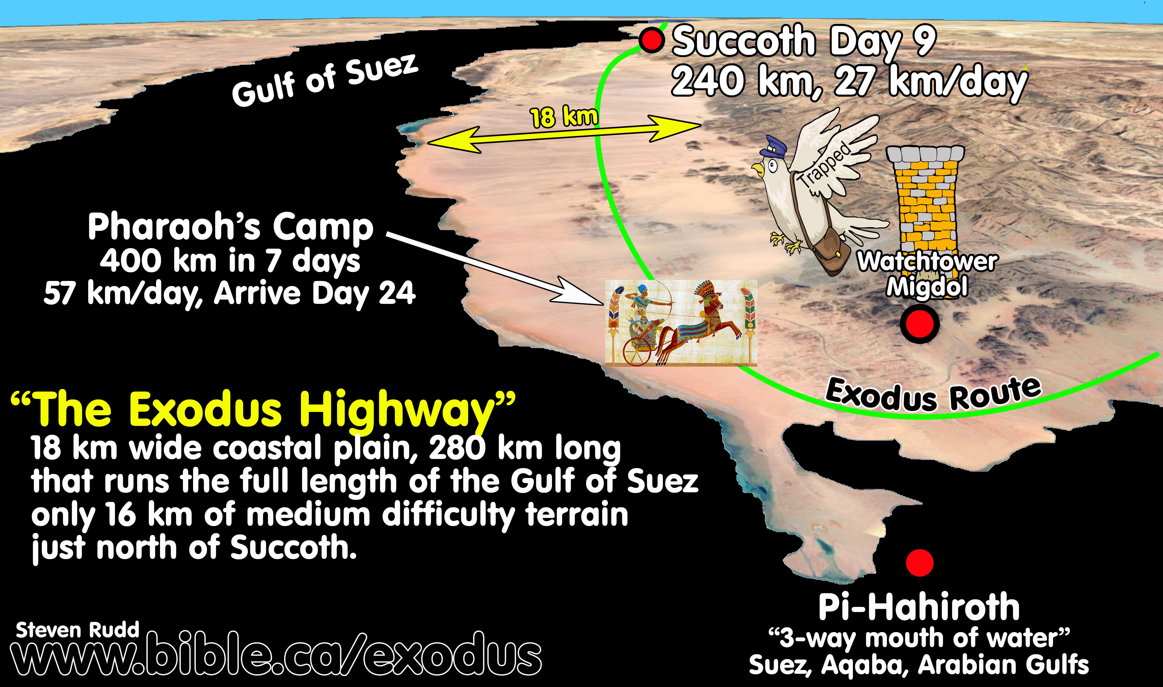
3. Fritz has Pharaoh overtaking Moses at Etham, 4 days before reaching the Red Sea:
a.
Glen Fritz Itinerary:
Day 1: Moses leaves for Nuweiba.
Day 4: Pharaoh is self-triggered and begins chasing Moses.
Day 14: Moses arrives at Etham and Pharaoh overtakes Moses at Etham.
Day 18: Moses and Pharaoh both arrive at Nuweiba the same day and the
sea is divided that night.
Day 19-20: Moses crosses the Red Sea at Nuweiba.
b. In Fritz’s bizarre scenario, Pharaoh leaves Egypt only 4 days after Moses and catches up with Moses at Etham on day 14 with 4 more travel days to the Red Sea. This directly contradicts scripture that says Pharaoh overtook Moses at the Red Sea. Although Pharaoh has already overtaken the Hebrews at Etham, Fritz oddly describes the final 4 days of travel to the Red Sea as “Pharaoh in hot pursuit”. During this 4-day period the Hebrews navigated through the 78 km of narrow canyons of the Wadi Watir to Nuweiba. The entire length of the Wadi Watir canyon, from start to finish, was filled with Hebrews and animals walking in a long column procession. Most of the Hebrews would need to camp one to two days waiting to enter the Wadi Watir canyons as the mass of humans are channeled through the narrow canyons to the Nuweiba beach. While the first Hebrews reached the Nuweiba beach on day 18, the last would not arrive until day 20. Pharaoh’s army must stand idle beside the Hebrew camp at Etham on day 14 until Moses suddenly changes direction towards Nuweiba. With Pharaoh still standing idle Fritz suggests Pharaoh suddenly concludes Israel is “easy prey” after the Etham turn towards the Nuweiba beach. Fritz never tells his readers that Pharaoh had to slowly follow behind the last of the 3 million Hebrews for 4 days through the narrow canyons of Wadi Watir until the protecting angel stops the army just before reaching the beach on day 20. Fritz’s fantasy itinerary has Moses and Pharaoh arrive together at Etham on day 14, then arrive together as a single unit at Nuweiba on day 18 when the Hebrews crossed the Red Sea on the morning of day 19. It is impossible for all the 3 million Hebrews to walk 3 days through the narrow 150-meter-wide Watir Canyons and all arrive at the same place on day 18. The Tiran route has Israel walking an 18 km wide highway from Goshen to the Red sea.
c. Fritz’s scenario is unworkable, fictional and unbiblical. Scripture clearly indicates Pharaoh did not leave Egypt until after Etham backtrack. A messenger also needed to journey from Etham back to Pharaoh in Egypt to report that Israel was trapped, triggering him to start pursuing Moses. This means that a minimum of 5 days must be allocated for a messenger to travel from Etham to Egypt to Pharaoh and 7 days minimum for Pharaoh to reach the Nuweiba beach. Correcting the Fritz itinerary, the earliest a messenger could begin to travel to Egypt was day 17, arriving at Egypt on day 21 which results in 4 camp days for Israel at the Nuweiba beach days 18-21. Pharaoh leaves Egypt on day 22, travels 7 days and arrives at Nuweiba on day 29. Moses spent a total of 11 camp days at the Red Sea, days 18-29, then crossed the Red Sea on day 30. While this allows for the Hebrews to navigate the canyons of the Wadi Watir and arrive as one group by day 20, it is impossible for Moses to reach the Wilderness of Sin on day 31 (Ex 16:1)
d. The Tiran route is a perfect fit because Moses arrives at the Etham “dead end” on day 16 and “backtracks” only one day to the Red Sea camp on day 17 below the Egyptian watchtower (migdol). In the Fritz route, the Nuweiba beach is 4 difficult travel days from Etham but in the Tiran route they are only one easy day apart. At Tiran, the Egyptian guards who sat in the migdol that overlooked both Etham and the Red Sea camp, sent a messenger pigeon to Pharaoh in only 4 hours saying that Israel was trapped. Pharaoh is triggered to chase Israel on day 17 from Egypt, arriving at Tiran on day 24 during which time Moses camped a total of 8 days. The Hebrews cross the Red Sea on day 25, easily arriving at the Wilderness of Sin on day 31 (Ex 16:1).
e. Fritz citations:
i. “the Hebrews could have reached this destination in about 18 days. The Egyptian army, could have reached this beachhead in 14 days, Pharaoh would have had up to four days after the Hebrews departed Egypt to marshal his forces for pursuit.” (Lost Sea of the Exodus, Glen Fritz, p234, 2016 AD)
ii. ”The Egyptian army … reached the point of the Etham encampment in about 10 days. While at the Etham encampment, a divine command was given to turn and proceed to encamp by the sea” (Lost Sea of the Exodus, Glen Fritz, p228, 2016 AD).
iii. “Sometime after the turn at Etham, the Hebrews became “entangled in the land…shut in by the wilderness” (Exod. 14:3), leading Pharaoh to perceive that the Hebrews would be an easy prey.” (Lost Sea of the Exodus, Glen Fritz, p229, 2016 AD)
iv. “Based on the divine command given to Moses at Etham, to turn, and encamp before the sea, this route funneled the Hebrews southward into the Wadi Watir with the Egyptian army in hot pursuit.” (Exodus Mysteries, Glen Fritz, p333, 2019 AD)
4. Fritz’s speed for Pharaoh’s army much too slow: Horse drawn chariots are capable of easily travelling 70 km per day. The main limitation is grazing time, water, and rest for the horses. While we agree with Fritz that the Hebrews walked 25 km per day to reach Etham on day 14 and Nuweiba no earlier than day 18, Fritz’s rate of travel for Pharaoh at 32 km per day is dramatically underestimated. What is surprising, is that if you use Fritz’s own numbers and rate of travel, Pharaoh arrives at the Nuweiba beach 1 day before Moses. This is explained because the Fritz itinerary has Pharaoh overtaking Moses at Etham on day 14, after which Pharaoh calmly and slowly walked 4 days behind the Hebrews to the Nuweiba beach on day 18. Using the correct rate of travel for Pharaoh’s chariots, not only does Pharaoh reach Etham on day 9, long before Moses does on day 14. Pharaoh also reached the Nuweiba beach on day 11, long before Moses does on day 18, FAIL
|
Exodus Journey 438 km from Egypt to Nuweiba |
||||
|
|
Hebrews |
Pharaoh’s Army |
||
|
Day | location |
Fritz/Rudd rate 25 km/day Leave Egypt on Nisan 15 |
Pharaoh Fritz rate 32 km/day Day 4 departure |
Pharaoh Herodotus 2.158 rate 38 km/day Day 4 departure |
Pharaoh Rudd rate 57 km/day Day 4 departure |
|
1 Hebrews leave Egypt |
25 |
|
|
|
|
2 |
50 |
|
|
|
|
3 |
75 |
|
|
|
|
4 |
100 |
32 |
38 |
57 |
|
5 |
125 |
64 |
76 |
114 |
|
6 |
150 |
96 |
114 |
171 |
|
7 |
175 |
128 |
152 |
228 |
|
8 |
200 |
160 |
190 |
285 |
|
9 |
225 |
192 |
228 |
342 FAIL Etham |
|
10 |
250 |
224 |
266 |
399 |
|
11 |
275 |
256 |
304
|
438 FAIL Nuweiba |
|
12 |
300 |
288 |
342 |
|
|
13 |
325 |
320 |
380 FAIL Etham |
|
|
14 Etham |
350 Etham |
352 |
418 |
|
|
15 Wadi Watir |
375 |
384 |
438 FAIL Nuweiba |
|
|
16 Wadi Watir |
400 |
416 |
|
|
|
17 Wadi Watir |
425 |
438 FAIL Nuweiba |
|
|
|
18 Nuweiba Beach |
438 Nuweiba |
|
|
|
a. Scripture gives us a daily travel rate: "It is eleven days’ journey from Horeb by the way of Mount Seir to Kadesh-barnea." (Deut 1:2) A direct route from Mt. Maqla/Lawz to Kadesh Barnea at Petra via Ezion Geber is 250 km which calculates a daily travel rate of 22 km per day. This is likely the time caravans would take to make the journey on camels. Camels and humans walk at the same rate of 5 km per hour. This allows for only 5 hours of travel a day. The Hebrews likely travelled most of the day and even during the night.
b. The Tiran route features an 18 km wide “Exodus Highway” for the entire 400 km route, except for a short 16 km section of medium difficulty terrain before Succoth. Pharaoh would have travelled an established coastal highway the entire route, meaning he could travel at daily rates much faster than the normal walking rates. All 3 million Hebrews reach Tiran on day 17 and camp 8 nights waiting for Pharaoh to arrive on day 24, then cross on day 25. For the Tiran route, Rudd used 57 km per day as the speed of Pharaoh’s army to travel 400 km from Egypt to the Straits of Tiran in 7 days.
c. The Nuweiba route from Egypt to Etham was also on the major trade route highway that would facilitate Pharaoh’s horse drawn chariots to travel at more than double the normal walking rate.
d. Applying this same 57 km per day rate of travel to the Nuweiba route, that was used in the Tiran route, Pharaoh’s army overtook Israel on day 9 and arrived at the Nuweiba beach on day 11. FAIL
e.
Herodotus 2:158 says it took 4 days to travel the full length of the 150
km canal built by Darius I around 500 BC. This produces a daily travel rate of
38 km per day. The journey is by foot not by ship, because a trireme, with three sets of rowers could travel the entire
150 km in less than a day (7 hours) at speeds of 22 km per hour. Although
there are conflicting reports of whether Darius I completed the canal from
Bubastis to the Gulf of Suez, Herodotus’ report, coupled with direct
archaeological evidence proves he completed it and it was in full operation in
his lifetime. The cuneiform stele of Darius I dates
to about 500 BC and was discovered at Kabret at the Little Bitter Lake. The
Darius stele reads: “I seized Egypt; I gave
order to dig this canal from a river by name Nile which flows in Egypt, to the
sea which goes from Persia. Afterward this canal was dug thus as I had ordered
and ships went from Egypt through this canal to Persia thus as was my desire.”
(Darius I stele, Karbret, 500 BC) Using Herodotus’ rate of travel of 38 km per
day means that if Pharaoh left Egypt on day 4 the army would overtake Israel at
Etham on day 13, which is one day before the Hebrews arrived on day 14. At 38
km per day, Pharaoh would arrive at Nuweiba on day 15, three days before Moses
arrived. FAIL
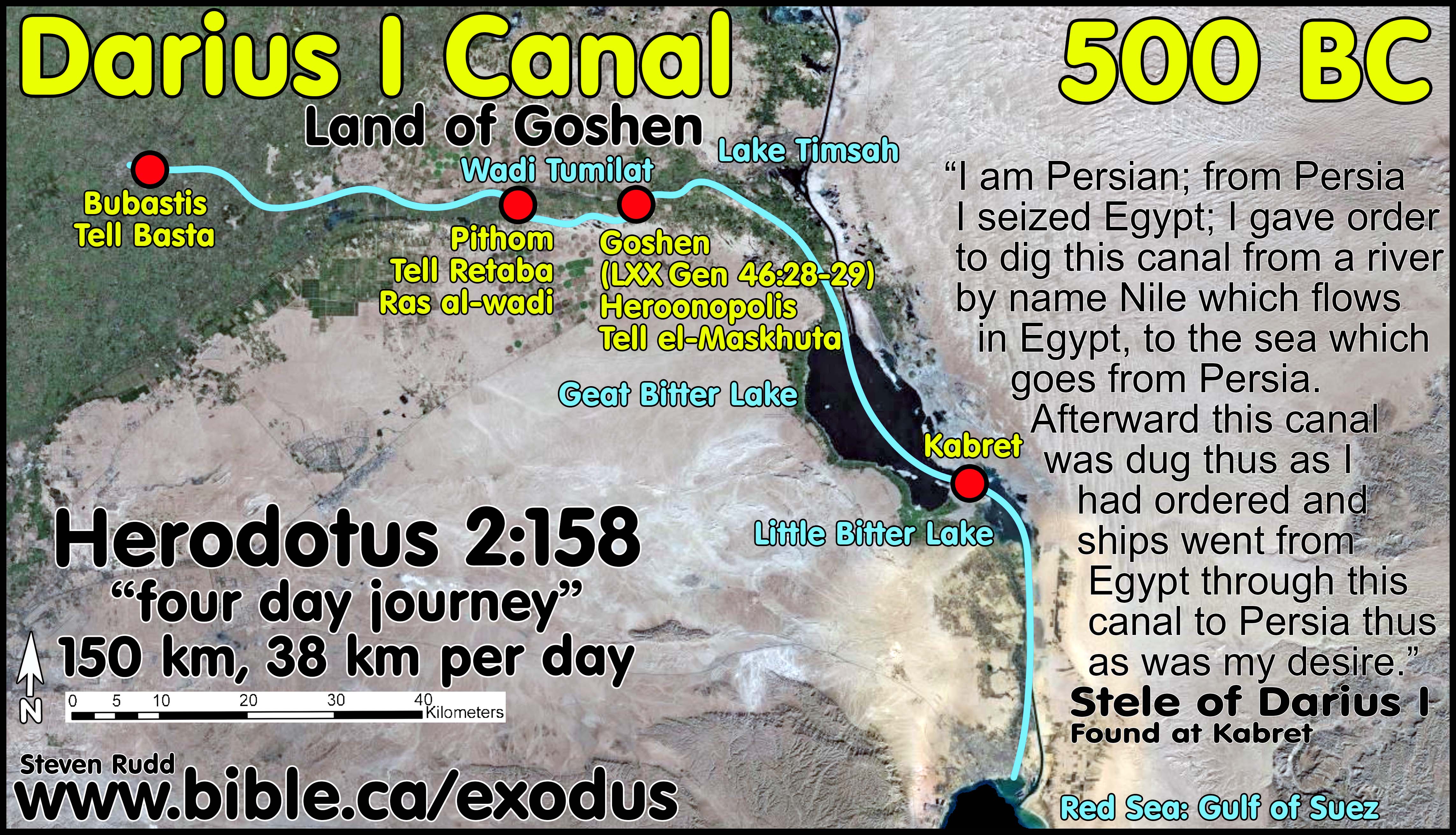
5. 273 km of difficult and narrow canyon travel of Fritz’s 888 km Nuweiba route is a huge problem:
|
Glen Fritz Nuweiba Canyon travel Total distance from Goshen to Sinai: 888 km |
|
|
Goshen to Nuweiba: |
78 km |
|
Nuweiba to Elim: |
141 km |
|
Dophkah to Alush: |
54 km |
|
Total |
273 km (31%) |
a. Canyon travel is one reason why any exodus route through the Nuweiba beach is impossible.
b. Fritz correctly numbers the Hebrew exodus population in the millions not thousands, but this greatly slows down his net travel rates because his route has 273 km (31%) of difficult terrain or difficult canyon travel from Goshen to Sinai.
c. Canyon travel does not slow rate of travel down for those walking at the lead or tail end of the human convoy, but it adds many extra camp days making the journey longer. Those at the lead must camp and wait for those at the tail to arrive and those at the tail must camp waiting for their opportunity to enter the canyons. Canyon travel makes it impossible for the entire group to travel as a single unit. Canyon travel always requires breaking the larger group up and sending them through in smaller stages.
d. Fritz never considers the many extra camp days that canyon travel adds to his flawed and poorly thought out itinerary.
e. Scripture indicates that only between the Wilderness of Sin and Rephidim did the Hebrews need to travel in small group stages through the canyons. This confirms the Tiran route as correct and the Nuweiba route as wrong because the Nuweiba route has three sections of canyon travel, but the Bible says there is only one.
6. 78 km of canyon travel through Wadi Watir before the Nuweiba beach:
a. We agree with Glen Fritz who calculated it would take three days for the first who entered the Wadi Watir to travel 78 km through the canyons and finally arrive at the Nuweiba beach on day 18. What Fritz never considered is that the last of the Hebrews did not arrive at the Nuweiba beach until day 20. Fritz has Israel travelling 205 miles from Goshen to reach Etham on day 14 where they “turned” south towards the Wadi Watir that leads many places, one of which is the Nuweiba Beach. We agree with Fritz that it is a four-day, 67-mile (107 km) journey from Etham to Nuweiba and that the first Hebrews arrived at the beach on day 18. The 3-day journey through the Wadi Watir is 78 km (49 miles) long and averages 150 meters wide with a total area of about 12 km2. The three million Hebrews with their animals require an area at least 10 km2 (3 km x 3 km = 3000 meters x 3000 meters). The convoy of Hebrews in the canyon is 60 km long x 150 meters wide. This means the Hebrews would fill 60 km of the 78 km length of canyon. The canyon travel before the Nuweiba beach added two additional camp days to the itinerary. During days 17-18, the last of the Hebrew to enter the canyons had to camp at least two days waiting for their turn to join the processional convoy to Nuweiba as the first group walked through the Wadi Watir. During days 19-20, the first Hebrews arrived at Nuweiba on day 18, then had to camp two days waiting for the final group of Hebrews to arrive on day 20. In Fritz’s flawed chronology, Israel started crossing the Red Sea on day 19 but he never allowed any time for the last of the Hebrews to arrive at the Nuweiba beach after navigating the canyons. The first men to reach the beach would need to wait 2 days for the last to arrive. The last men to enter the Wadi Watir canyon would likewise need to wait 2 days until the procession flow allowed them to star walking. Fritz has Pharaoh arrive at the Nuweiba beach on the same day (18) as when the first of the Hebrews travelling in convoy arrived but before the last of the Hebrews had reached the beach. This means that the pillar of cloud prevented both Pharaoh and half of the 3 million Hebrews from reaching the Nuweiba beach.
b. This logistical problem of canyon travel in a 60 km long processional human convoy, adds 2 camp days to the Nuweiba crossing itinerary and was neither addressed nor resolved by Fritz. In Fritz’s flawed timing scenario, there were Hebrews on the far shore of the Red Sea while others were still walking the Wadi Watir canyons to reach the Red Sea that had already been parted and they missed the entire miracle as eyewitnesses! But this is impossible because scripture says the army was blocked by the angel at the Nuweiba beach, which means nobody had yet started crossing until the next morning after the army arrived.
c. An Egyptian messenger who traveled from Nuweiba back to Egypt with word Israel was trapped would need to use this same canyon that is clogged with Hebrews travelling the opposite way towards the Beach. This would delay or slow down the Egyptian messengers and add three extra days before they began their 5-day trip back to Egypt.
7. 141 km of canyon travel after crossing the Red Sea to Wilderness of Sin:
a. After crossing the Red Sea, the 170 km route to the Wilderness of Sin is a whopping 141 km of canyon travel which amounts to 83%. The canyon travel and the two-day double-back from Elim (Midian at Al Bad) to the second Red Sea camp at Maqnah and back to Midian, makes it impossible for Moses to reach the Wilderness of Sin on day 31. Even if Moses could arrive on day 31, it would take two additional days for the 60 km column of trailing Hebrews, travelling in small stage convoys, to arrive on day 33.
b. In a failed attempt to salvage his impossible Nuweiba crossing, Fritz splits the 3 million Hebrews into two travel groups. Moses and the larger main group bypass the two day backtrack to the second Red Sea camp and travel directly from Elim to the Wilderness of Sin. A smaller group go to the second Red Sea camp finally arriving two days later than Moses.
c. While Fritz states the second group who went to Maqnah trailed behind the first group by a couple of days because they travelled an additional 64 km, he fails to add an additional two camp days to his itinerary. “However, the initial arrival of the multitude in the Wilderness of Sin likely preceded the hundreds of thousands trailing behind by several days.” (Exodus Mysteries, Glen Fritz, p399, 2019 AD)
d. The result is that the Hebrews almost never travel as a single group between Nuweiba and Rephidim.
8. 54 km of canyon travel between Dophkah and Alush:
a. In Fritz’s Nuweiba route, there are 54 km of canyon travel between Dophkah and Alush which we calculate would take three days to navigate. It is four days from the Wilderness of Sin to Alush. One day to reach the first canyons, and three days travelling through the canyons until reaching the open upper plateau.
b. Since the 150-meter-wide column of Hebrews travelling the narrow canyons is 60 km long, the entire canyon is full of Hebrews adding an additional three camp days. As the first Hebrews enter the canyons, most would need to camp three days waiting for their turn to start walking from Dophkah to Alush. Those who arrived at Alush first would keep travelling to Rephidim. At Rephidim the Hebrews would regather as a single unit to make the final trip to Sinai.
c. Nuweiba route 2nd Sabbath: Moses would arrive at Alush on day 52 which was the second sabbath day. This means there is a 50 km long string of humans travelling the canyons between Dophkah and Alush who had to stop and camp in the canyons to keep the Sabbath holy. On the second sabbath, some of the Hebrews camped at Alush, while most of the Hebrews camped in the canyons. The entire canyon system from Dophkah to Alush was filled with Hebrews keeping the sabbath. The timing of the second sabbath, with the 3 million Hebrews resting in a 50 km string from Alush back to Dophkah is incongruent with the providence of God who would have ensured that the Hebrews would enjoy their second sabbath together as a single unit in one place. The itinerary of the Tiran crossing has all Hebrews celebrating the 2nd Sabbath at Rephidim, as a single unit, after they have defeated the Amalekites on the day before they reached Mt. Sinai on day 47. The dates of the sabbath days are different for the Nuweiba and Tiran route because they are determined by their arrival date to the Wilderness of Sin.
9. No migdol, no messenger at Nuweiba beach: A migdol is a
military watchtower and fortress structure.
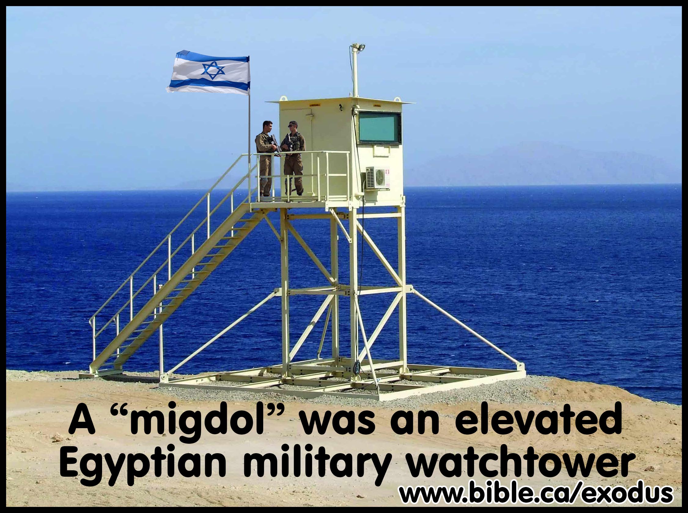
a. Migdols were very common in the ancient world and Egypt had many migdols throughout its territory. Forest fire towers in national parks spot fires and migdols spot foreign military attacks. Egyptian migdols can be fortified structures with high walls and elevated stone or wooden platforms, or simple viewing stations perched on the top of a hill.
b. Glen Fritz knew the Nuweiba beach was a very unlikely location for a military watchtower, so being a geographer instead of an archaeologist, he redefined “migdol” as a large, massive mountain range west of the Nuweiba beach rather than an Egyptian watchtower overlooking the Nuweiba beach. There are no examples in ancient literary sources that a migdol was merely a mountain range. In all literary sources and Egyptian reliefs, a migdol was a manned and elevated military fortress. Either way, there was no Egyptian military watcher at the Nuweiba beach which removes the possibility of using messenger pigeons to fly back to Egypt with the message Israel was trapped.
c. Another option to get a message back to Pharaoh from the Nuweiba beach was by sea or horseback. It would take a messenger 5 days to ride from Fritz’s location for Etham and 7 days from the Nuweiba beach to get a message to Pharaoh.
d. Sending a message by sea on oar powered boats is the only other option. Assuming a continuous speed of 10 km per hour to travel the 490 km from Nuweiba to the port of Suez, it would take the messenger 49 rowing hours. The messenger would arrive at the port of Suez in 4 days if he rowed 12 hours a day. From Suez it is another 125 km over land to reach Pharaoh which would take a horseback rider another 2 days minimum. Even at these maximum possible speeds, it would take a navel messenger 6 days to get a message to Pharaoh that Moses was trapped at the Nuweiba beach. If the boat left on day 18 when Moses arrived at the Nuweiba beach, the messenger would not reach Pharaoh until day 24 and Pharaoh would not arrive at Nuweiba until day 31. Scripture says Moses arrived at the Wilderness of Sin on day 31 (Ex 16:1).
e. Getting a message to Pharaoh that Israel was trapped is an unsolvable problem for the Nuweiba crossing. The Straits of Tiran on the other hand is a critical and necessary location for an Egyptian migdol military watchtower to monitor mariner traffic and an early warning system of military attacks on Egypt. The straits of Tiran overlook the three-way intersection of the Arabian, Aqaba and Suez gulfs. Messenger pigeons were used in Egypt at the time of Abraham and the migdol at Tiran would be equipped with them as fast communication systems. Even without messenger pigeons it is only 290 km to reach the port of Suez then another 125 km to Pharaoh. Messenger pigeons are seen in the dove of Noah who returned with the message the flood had subsided and in the 9th century BC: “Who are these who fly like a cloud and like the doves to their lattices [dove-cotes]?" (Isaiah 60:8)
10. Impossible
to be trapped at the Nuweiba beach:
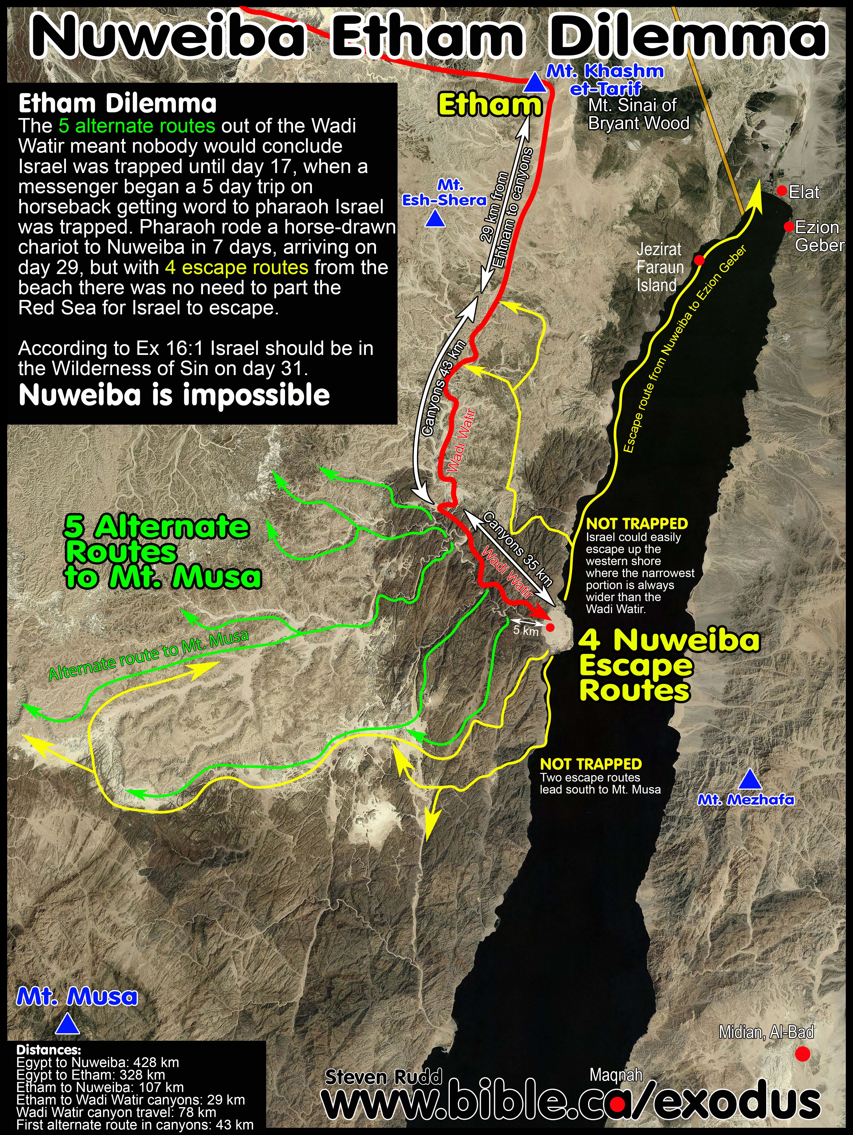
a. Scripture had the dead end at Etham not the Red Sea. Fritz has the dead end at the Nuweiba beach.
b. Fritz emphasizes being trapped by both the canyons of Wadi Watir and the Nuweiba beach: “The prospect of being entrapped by the wilderness easily applies to the confines of the Wadi Watir canyons, which terminate as a narrow gap west of the Nuweiba beachhead.” (Lost Sea of the Exodus, Glen Fritz, p228, 2016 AD)
c. Impossible to be trapped in Wadi Watir: In the Nuweiba crossing, the topography of the Wadi Watir has 5 alternate exit routes, before reaching the beach, that branch off and lead back into the central Sinai plateau. The last of these branches out of the Wadi Watir, lead directly to Mt. Musa at St. Catharine’s monastery. Therefore, only after passing this final exit on day 17, the Egyptians would know for certain that Israel was headed for the Nuweiba beach and not the Mt. Musa area.
d. Our analysis determined that the most logical day an Egyptian observer would conclude Israel was tapped at Nuweiba was no sooner than late day 17 and most likely when Moses reached the beach on day 18. Day 17 is when Moses past the final exit route leading out of the Wadi Watir to Mt. Musa. This creates huge logistics problems of how someone would be able to observe the Hebrews at or near the Nuweiba beach and be able to ride past the massive convoy of Hebrews filling the Wadi Watir return to Egypt with the message that Israel was trapped, triggering Pharaoh to return with his army.
e.
Impossible to be trapped at the Nuweiba beach: Fritz’s problem is
that 31% of his exodus route is canyon travel (273 km of canyon travel of the
total 888 km long route). Since Israel had just navigated 78 km of canyon
travel to reach the Nuweiba beach, they would automatically think to use all
four canyon escape routes when Pharaoh arrived. The escape routes are no more
restrictive than the 78 km of canyon travel they had just walked through to
reach the beach. One escape route is the western coastline of the Gulf of Aqaba
to Elat. The proof that this is a viable escape route for 3 million Hebrews, is
that some exodus route maps, like that of William Schlegel in his Satellite
Bible Atlas, published in AD 2013, track Israel from Mt. Sinai at Mt. Musa directly
through the Nuweiba beach as a transit point and up the coastline to Elat in
order to access Kadesh Barnea. Since the traditional exodus route from Mt. Musa
is often mapped through the Nuweiba beach as a transit point to Kadesh Barnea,
Pharaoh would have also understood this and never concluded Israel was trapped
at Nuweiba. At the Nuweiba beach, they could escape south and north through
several canyons and avoid the Egyptian army that are just as accessible as the
canyons leading to the Nuweiba beach. If, as Fritz suggested, the informant was
familiar with the topography at the Nuweiba beach, the message to Pharaoh would
be quite different because the Hebrews could easily scatter. The western
shoreline of the Gulf of Aqaba is narrow at times but always wider than 150
meters. Much of the 78 km of the Wadi Watir is only 150 meters wide leading to
the Nuweiba beach. Additionally, when you leave the Nuweiba beach and travel
north towards Ezion Geber, there are 13 wadis that branch west towards the Sinai
plateau. Many of them dead-end 4 to 7 km from the coast but several provide
easy escape. While these 13 canyon wadis don’t all provide a way of escape,
they would provide easy cover and hiding places for the scattered Hebrews to
provide easy cover from the Egyptian army. The 78 km of canyon travel leading
to the Nuweiba beach, was like a practice “fire drill” in preparation for when
Pharaoh arrived and they used the canyons to escape!
![]()
f. Totally trapped at the Straits of Tiran: The 3 million Hebrews walked from Egypt to Tiran and hit the dead-end mountains at Etham. The entire route between Egypt and Tiran features an 18 km wide flat coastal plain, except 16 km of medium difficulty terrain before Succoth. This allowed the Hebrews to move as a single group of 3 million from Goshen to the final camp spot at the straits of Tiran. Unlike Nuweiba, the northern shoreline at Tiran is 100% impassable because the sharp rock cliffs come to the edge of the water. Unlike Nuweiba, there is no escape route through the canyons from the Tiran beach because they either quickly dead end or lead directly to the Egyptian army at the Gulf of Suez. Pharaoh would logically conclude they were trapped without escape. By simply arriving at the Tiran beach from Egypt, Pharaoh would understand he could trap the entire group, like corralled cattle in a fenced enclosure, by blocking the entrance door. The Hebrews would not even consider escaping through the canyons since they have never travelled by canyons up to this point. Israel came to the dead end at Etham because of the massive mountains at the Straits of Tiran, then backtracked 24 km and camped at the Red Sea. This would clearly bait and trigger Pharaoh into attacking as Exodus 14:2-4 describes. Pharaoh was triggered to leave Egypt and start chasing Israel on day 17 when Israel was dead ended at the mountains at Etham and camped beside the Red Sea.
11. The
Nuweiba beach was smaller and the crossing was deeper 3400 years ago:
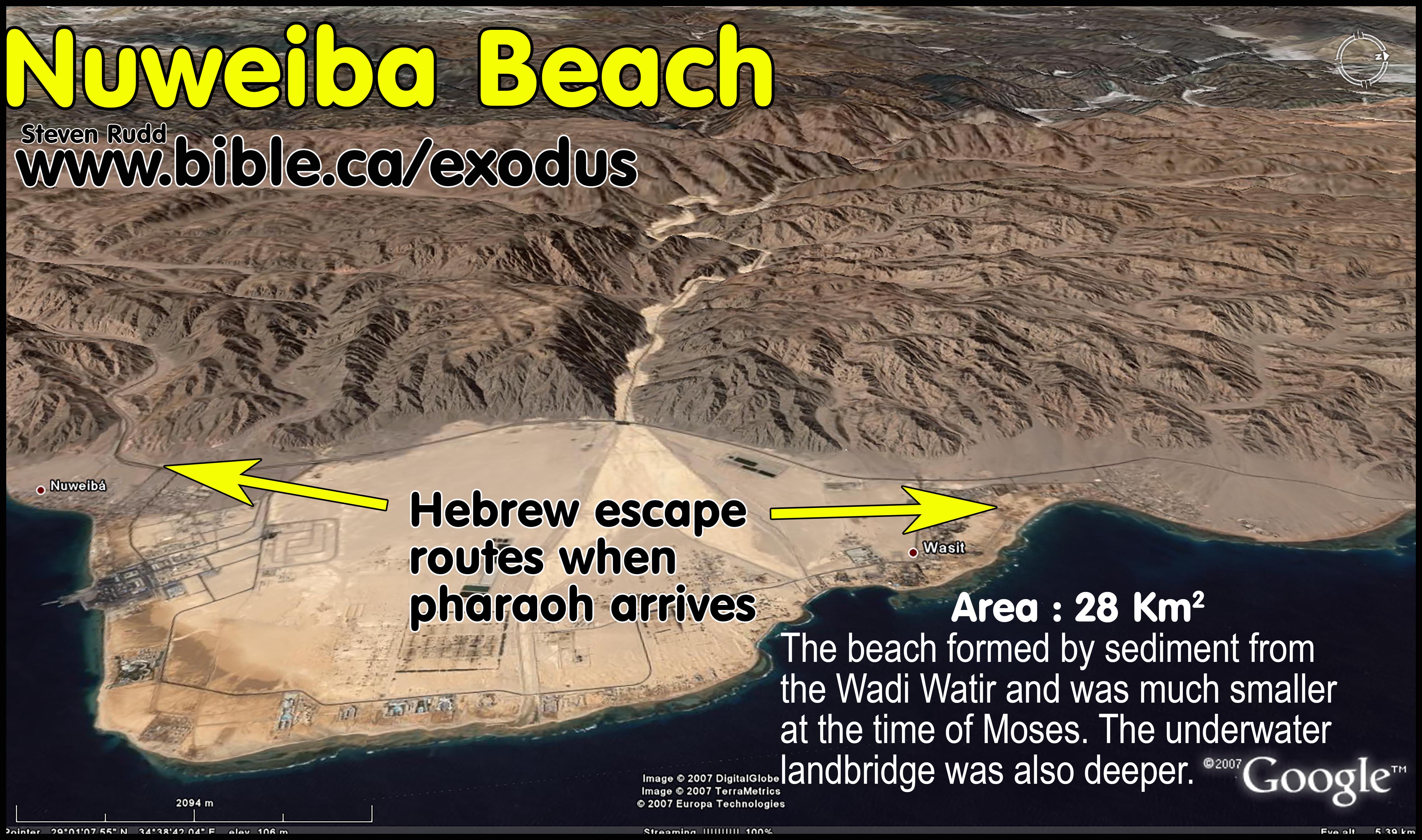
a. Geographically, the Nuweiba beach was formed from accumulated sand sediment transported by water through wadis over thousands of years.
b.
There is a string of 15 beaches that line the west coast of the Gulf of
Aqaba that were formed by sediment transported by a wadi water system. The
Nuweiba beach is in fact, the largest of fifteen of these wadi-sediment sand
beaches that line the entire length of the western shore of the Gulf of Aqaba.
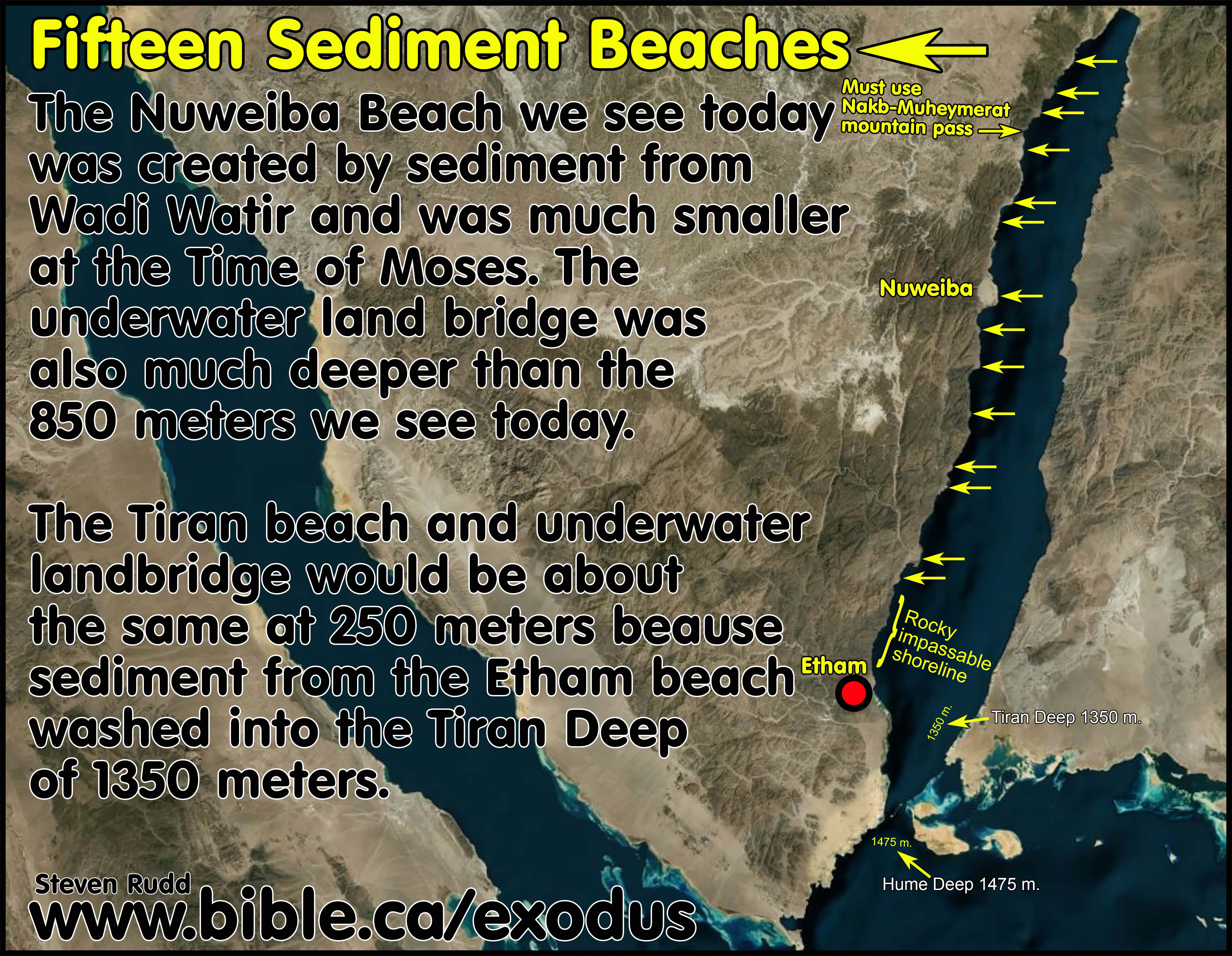
c. During times of heavy rain, sediment washes through the wadi and is deposited on the beach and ocean floor. While this slow geological process easily explains how the natural underwater land bridge formed, it also proves the Red Sea crossing at the time of Moses was much deeper than the 850 meters we see today.
d. Bathymetric charts confirm that the underwater land bridge at Nuweiba was formed by sediment washed into the Gulf of Aqaba since the Noahic flood in 3298 BC. The Nuweiba underwater land bridge would be much deeper than 850 meters 3400 years ago. The beach on the Arabian side of Nuweiba is the largest wadi-sediment created beach on the eastern coast of the Gulf of Aqaba. This means that the two largest wadi-formed beaches on the Gulf of Aqaba just happen to be directly across from each other. The massive amount of sediment washed into the Gulf of Aqaba during rainstorms through the wadis is what created the underwater land bridge.
e. The natural sandy beach at the Straits of Tiran was not formed by wadi sediment and is part of an 18 km wide corridor that extends hundreds of kilometers north. The Tiran beach would be about the same size today as it was 3400 years ago. The 250-meter underwater land bridge at Tiran would be about the same depth today as in the time of Moses. The wadi sediment which formed the sand beach at Etham, would be washed into the Tiran Deep which even today is 1350 meters. It is more likely that the 16 km crossing at the Straits of Tiran was as short as 8 km because at the time of Moses the Wilderness of Shur was directly connected to Tiran Island. This land was gradually eroded into the ocean over time to the 16 km crossing we see today.
f. The conclusion is that at the time of Moses, geographically, the Nuweiba beach was smaller and the crossing deeper but the Tiran beach was larger and the crossing was shallower than what we see today.
12. Fritz has wilderness of Shur misplaced far away from Midian: Ishmael lived in the Wilderness of Shur inside of which was Midian (Al Bad). The Nuweiba crossing places the Wilderness of Shur in a small and obscure location that is a mix of sandy beaches and mountains, isolated from historic Midian at Al Bad. The Tiran crossing is a perfect fit with the wilderness of Shur at Al Bad. Fritz has misidentified the Wilderness of Sin in his Nuweiba route at the true location of the Wilderness of Shur in the Tiran route. The Wilderness of Shur of the Tiran route not only includes Midian, it is a large flat uniform area of geography that would easily take three days to traverse. The geography of the Wilderness of Shur in the Nuweiba route is a mix of sandy shores and canyons through mountains and is far from Midian where the Ishmaelites and Midianites lived historically.
13. Glen
Fritz distorts and misrepresents the slope and transect of the Straits of Tiran
crossing: Just when you thought the misinformation surrounding the
underwater land bridge transect slopes at Nuweiba could not get any worse with
Ron Wyatt’s distorted depth charts, Glen Fritz, with a PhD in geography,
outdoes Ron Wyatt by publishing his own set of distorted depth charts for both
Nuweiba and the Straits of Tiran. Fritz’s PhD 2006 AD dissertation was called
“The Lost Sea of the Exodus”. He turned his PhD dissertation into a book of the
same title in 2007 AD, then published the second edition in 2016 AD. The
distorted slope transect chart discussed here comes from Glen Fritz, “The Lost
Sea of the Exodus”, p274, 2016 AD and he used this same graphic in the Red Sea
Miracle II movie series directed by Tim Mahony. Fritz presented the graphic in
the movie as an optical comparison of the slopes, even though directly below
the graphic in his book he said, “The depths and distances in these graphs are
not drawn to scale” (Lost Sea, p274). Steve Rudd even told Glen Fritz 4 months
before the movie came out, that the image was seriously distorted. Glen Fritz
mislead his movie viewers, who would wrongly conclude, based directly upon his
misleading visual graphic, that the Tiran slopes appear to be a serious problem
and the Nuweiba slopes are clearly superior. Fritz compounds the confusion
generated by Ron Wyatt surrounding the two underwater land bridges on the Gulf
of Aqaba rather than clarifying the actual facts. Red depths [-125 m] and horizontal lines [_____]
and distances [16 km] are not part of the
original charts but were added by Rudd to assist in clarity.
![]()
Distortions, errors and omissions in Glen Fritz slope transects:
a. The slopes of the underwater land bridges at Nuweiba and Tiran present no impediment to the Red Sea crossing. Both slopes are very similar. The difference is that the Nuweiba is over 3 times deeper than Tiran requiring 3 times the human effort.
b. Bottom levels are not indicated in either chart for Nuweiba (875m.) or Tiran (250m.) creating an illusion that Nuweiba is slightly deeper that 750 meters, when it is actually greater than 850 meters.
c. The graphic for the Nuweiba transect slope uses different vertical and horizontal scales than in the Tiran graphic even though they are presented side by side as apples to apples comparisons. Fritz’s vertical sea level depth scale for Nuweiba is 0 to -875 but for Tiran the bottom level is about 275 meters. The horizontal scale for Nuweiba is 19 km but for Tiran it is only 8 km even though they are presented side by side as apples to apples comparisons. Fritz presents a transect chart for the Tiran crossing in the movie as a “roller coaster” route, which clearly does not describe Rudd’s route at all. There are several proposed crossing tracks for Tiran.
d.
Fritz did not use a 1:1 horizontal to vertical scale which introduces
distortion and changes the slope of the bottom level. Fritz used a
horizontal/vertical scale of 1:2 for Nuweiba and 1:7 for Tiran. That makes the Tiran crossing look 7 times steeper than it
really is. It also makes the Nuweiba crossing look twice as steep as it
really is. Correcting his two charts onto the same 1:1 scale, his slopes are
almost a perfect match to what Rudd calculated for both Nuweiba and Tiran.
Fritz’s problem was not in his data, but his misleading presentation of the
data with conflicting and distorted scales for visual presentation to the
general public. He needs to put out a disclaimer now before the Unicorn
Internet Archaeologists (UIA) start misusing his materials in showing how
superior the slope of the Nuweiba crossing is compared to the Tiran crossing.
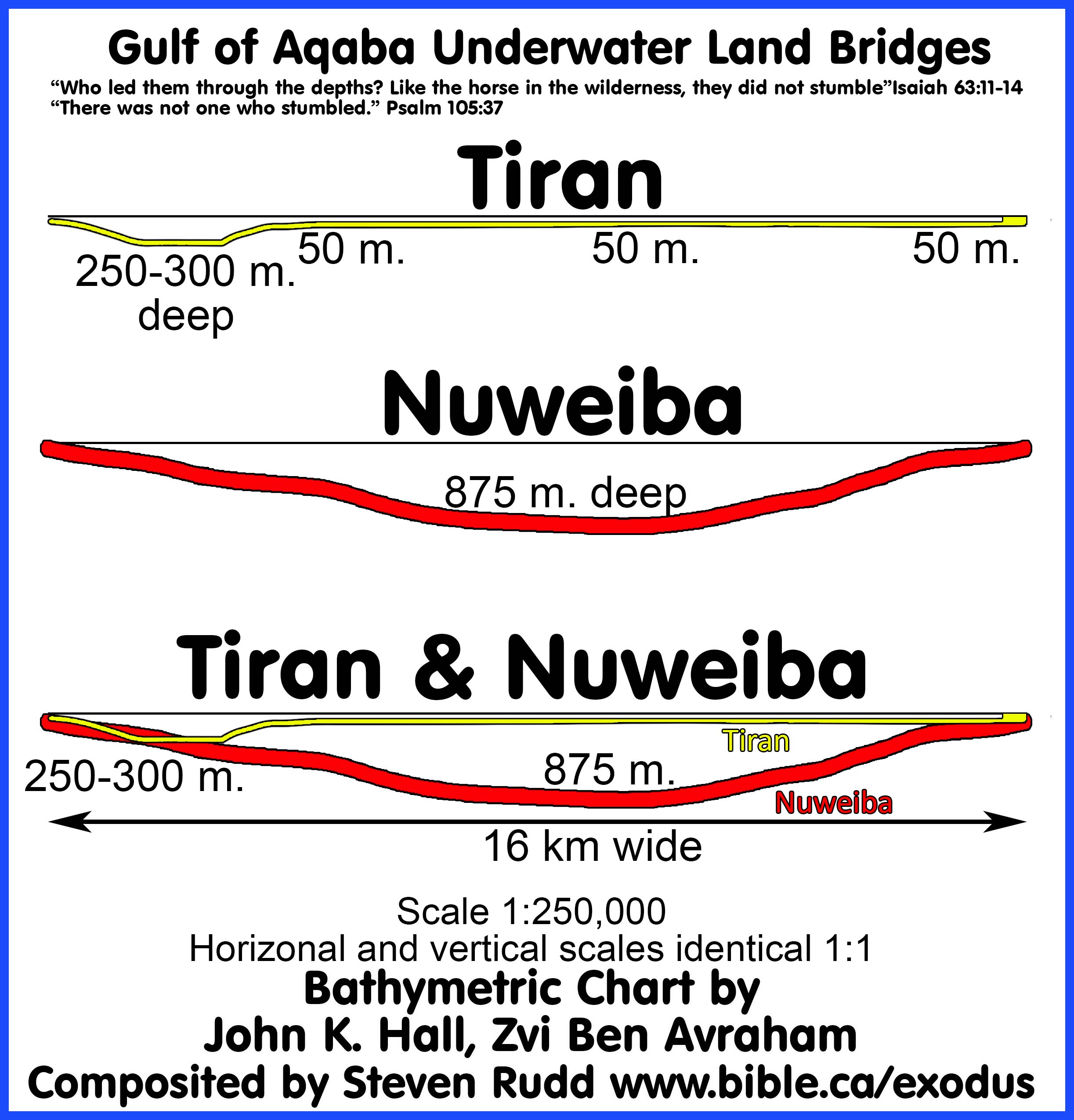
e.
Fritz misreads the bathymetric chart by Hall and Ben-Avraham and miscalculated
the distance of his own Nuweiba crossing at 19 km when in fact it is only 16
km. This distance is confirmed in Google Earth pro. To correct his defective
graphic, it must be compressed horizontally from 19 km to 16 km which has the
effect of making the slopes steeper than he represented. Strangely, in other
places Fritz contradicts himself by saying the crossing is 16 km, but on the
chart he used in the movie, he confused his audience again by labelling the
distance as 19 km. The Nuweiba and Tiran crossing are both 16 km.
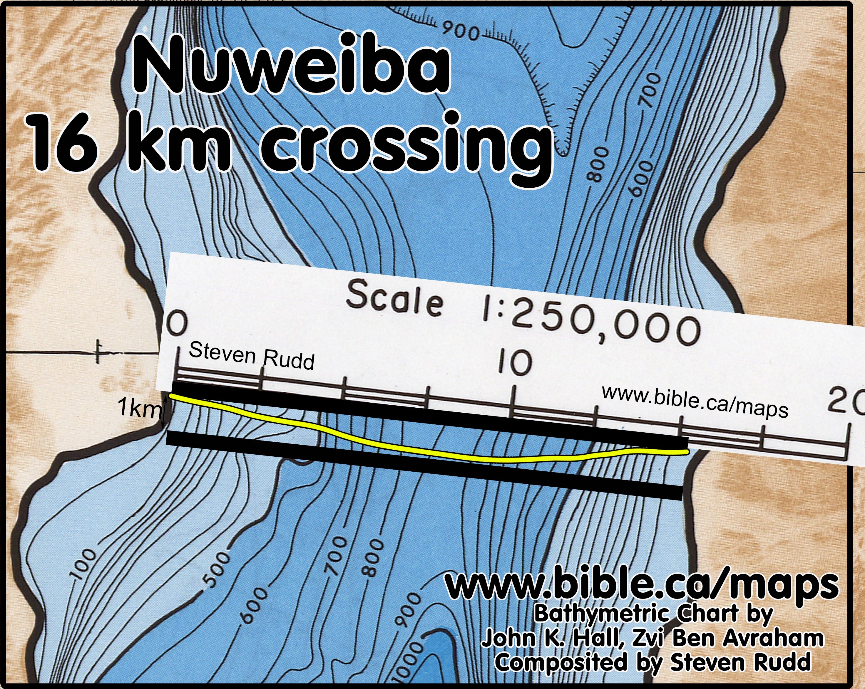
f.
Fritz’s 8 km track starts from the Tiran beach, passes through the
Enterprise pass, over top of the coral reefs which are 50 meters above sea
level, then through the Grafton pass and ends at Tiran Island. The Tiran
crossing proposed by Rudd has multiple possible transit tracks because the
seabed and topography have certainly changed in 3400 years. There are several
optional crossing tracts, all of which have similar slope profiles and are all
16 km long. Rudd favours a straight diagonal route that starts on the Tiran
beach just north of the Enterprise pass to the shore of Saudi Arabia. This
diagonal track reduces the slope of the Enterprise pass and never rises above
50 meters below sea level the entire crossing. The straight-line track may also
have been angled differently. A curved track also works well. Tiran Island may
have connected with the mainland at the time of Moses. We simply do not know
the exact crossing track today but there are many options that are perfect
fits.
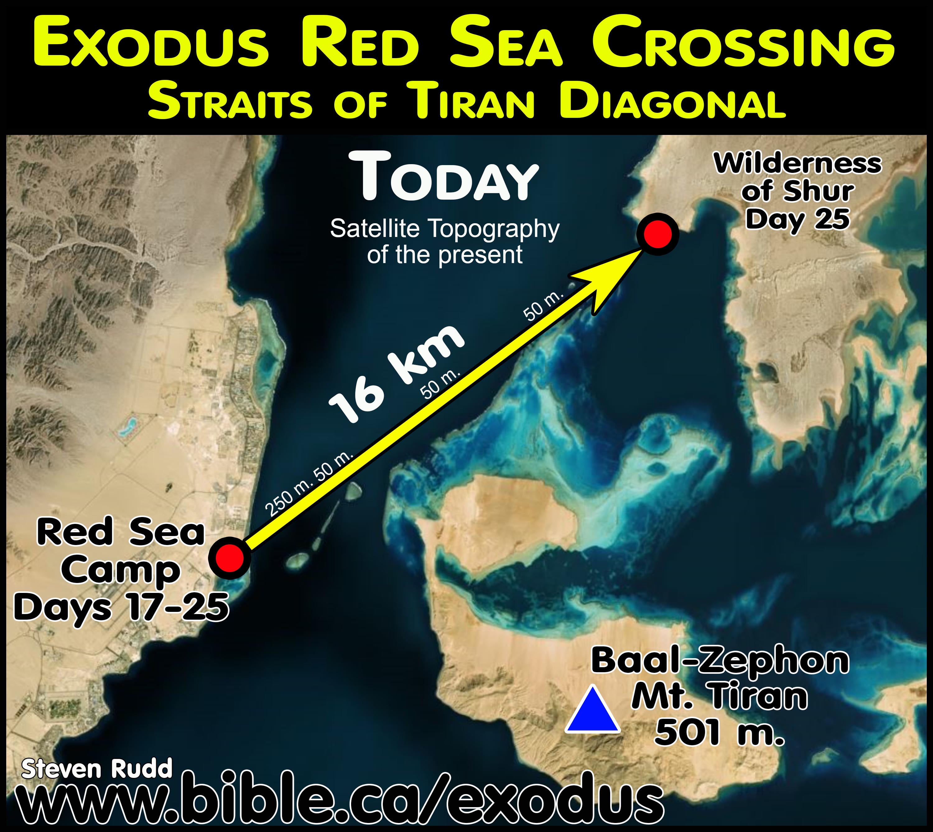
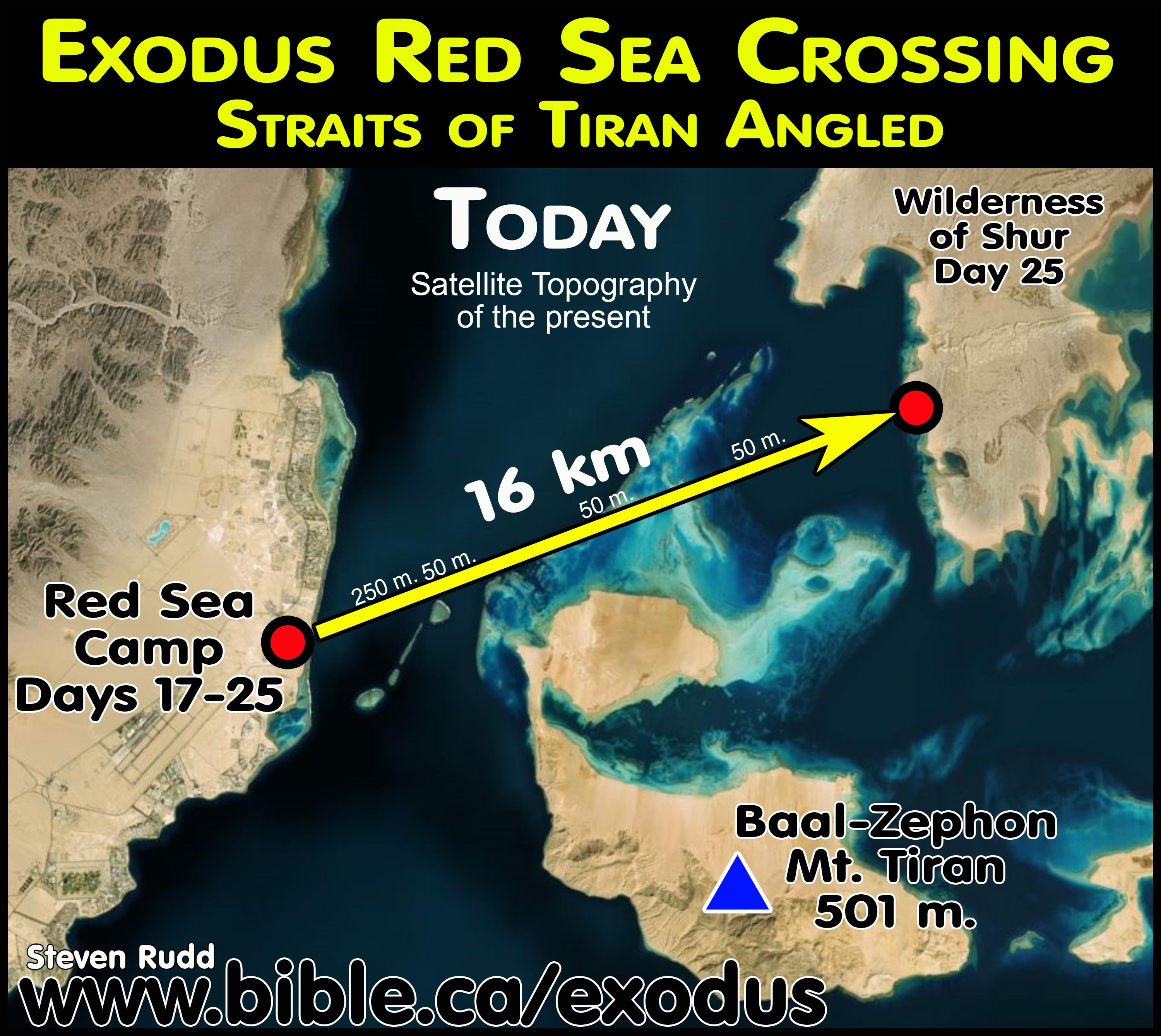
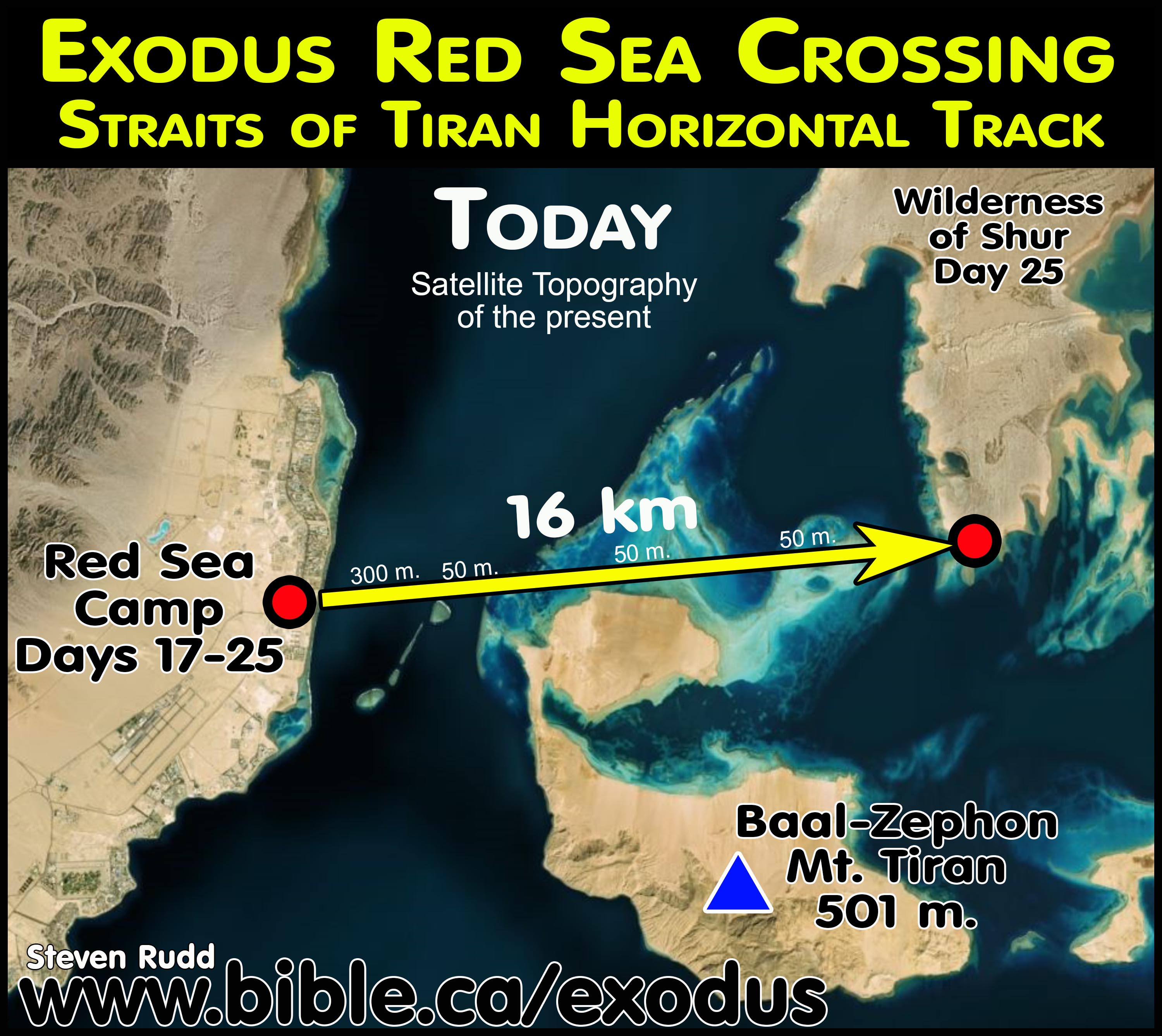
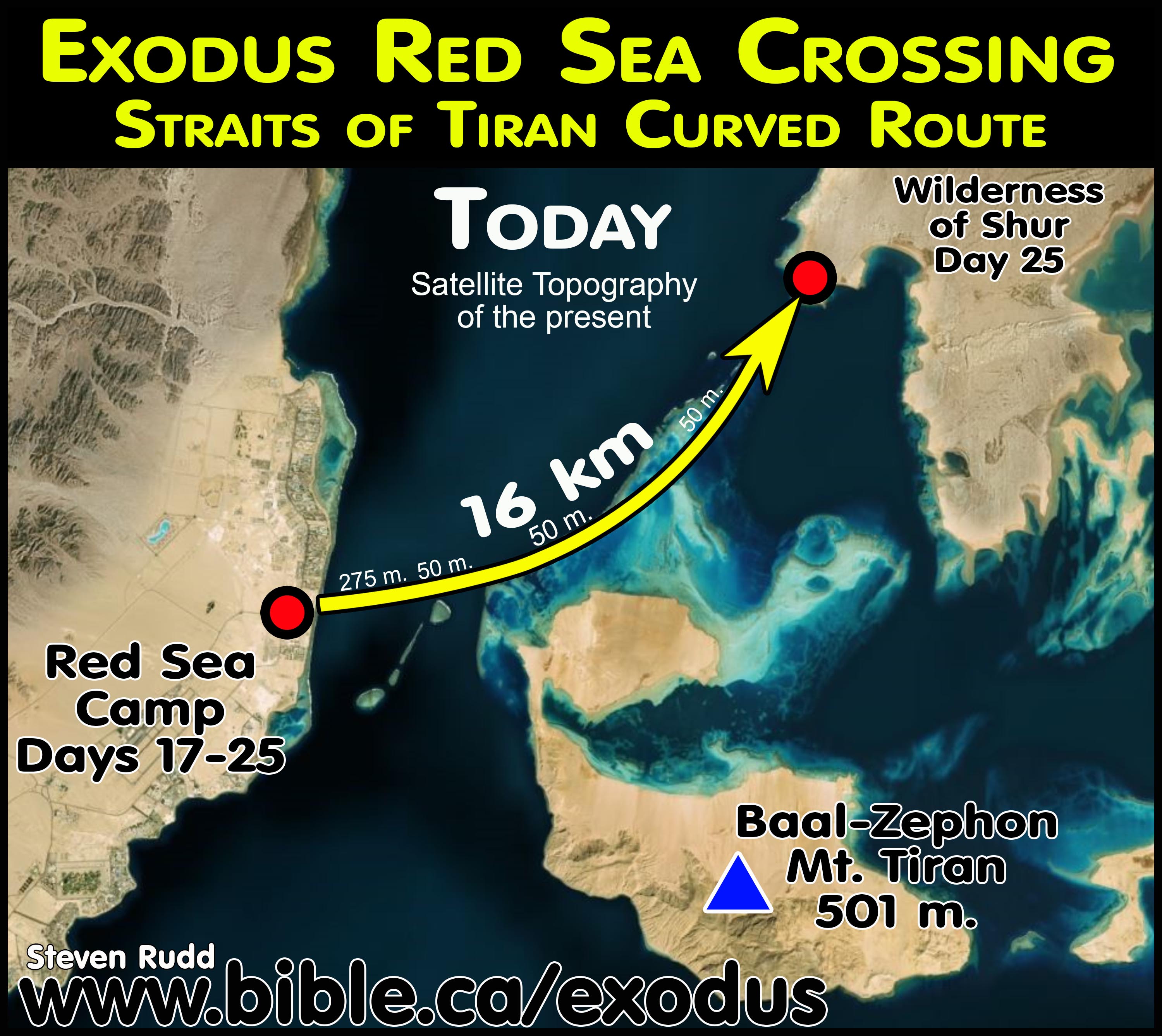
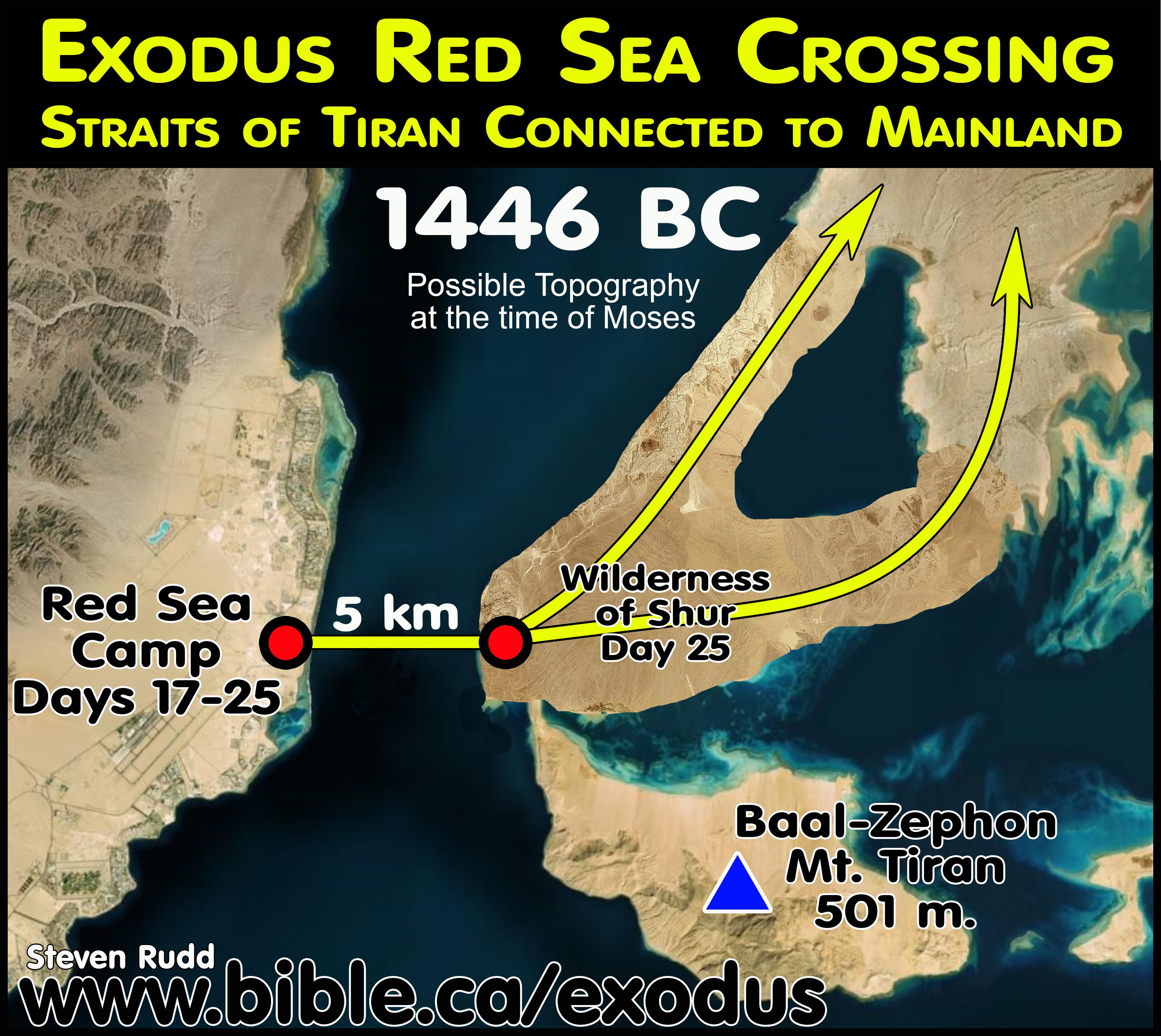
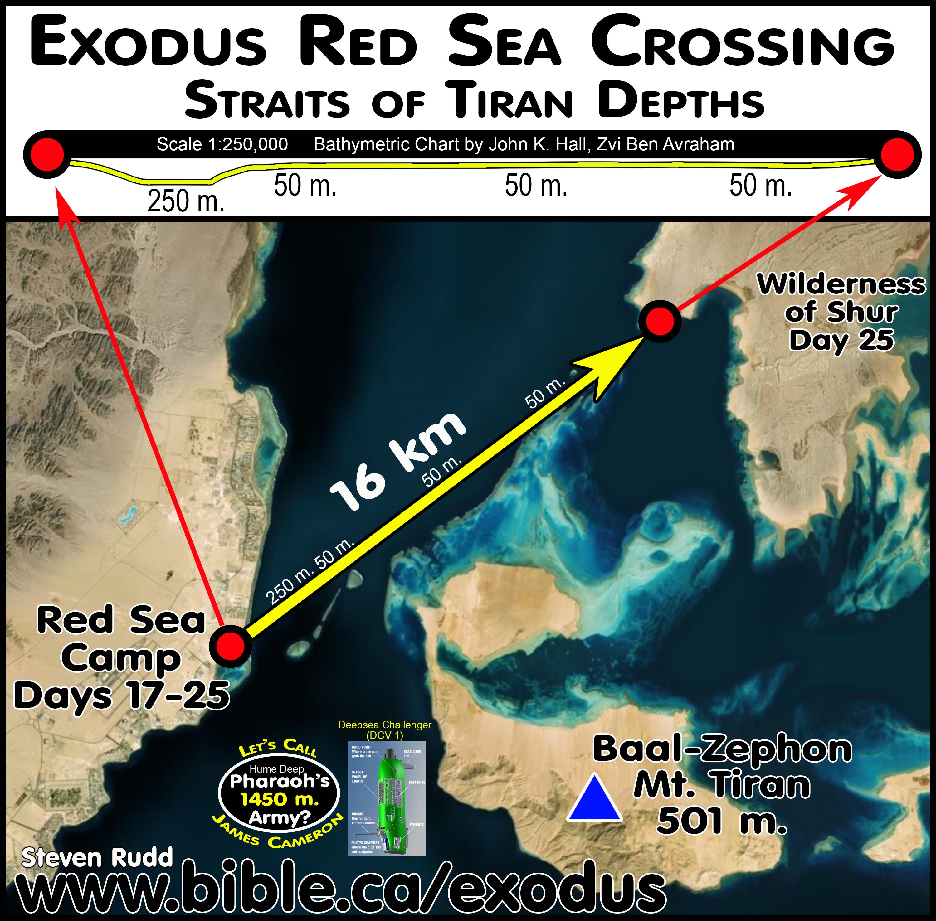
g. Glen Fritz marks sea level for Tiran at -50 meters. A water depth chart must mark sea level at zero. Apparently, Fritz marked the zero meters (sea level) at the top of the coral reef which he suggests towers 50 meters above sea level. When he marks sea level at -50 meters and doesn’t label the bottom level, it is impossible to know just how deep he considers the Tiran transect.
h. The two slope charts Glen Fritz used in his book, and the Red Sea Miracle II movie are so riddled with errors that they are worthless. In “APPENDIX 6: GULF OF AQABA BATHYMETRY” Fritz goes into great detail to explain how he created his two defective maps (Lost Sea, p272). It all looks so professional and convincing in print and on the silver screen, until you examine the details, gasp in puzzlement and start thoughtfully twitching.
i.
British admiralty nautical depth chart 12 is older and shows the depths
at Nuweiba to be around 765 meters but is included here for historical
purposes.

j.
Ron Wyatt’s famous slope chart of Nuweiba was distorted in the
horizontal to vertical scales in the ration of 10:1. This means the vertical
scale was 10 times the size of the horizontal scale. His horizontal scale was 1
km, but his vertical scale was 100 meters. Wyatt’s chart is from "The
Exodus Case" p190, by Lennart Moller and "The Exodus Conspiracy"
movie. Glen Fritz follows in Wyatt’s footsteps by publishing equally distorted
slope charts for both Nuweiba and Tiran. Instead of mopping up Wyatt’s mess,
Fritz further muddies the water.

14. Glen Fritz splits the Hebrews into two travel groups at Elim (Midian):
|
Nuweiba Crossing Failure: Second & Third Red Sea Camps Numbers 33:10 |
|||
|
TIRAN CROSSING |
NUWEIBA CROSSING |
||
|
Scripture: Tiran |
Glen Fritz southern route |
Alternate Northern Route |
|
|
Whole Group |
Main group |
Second group |
Whole Group |
|
Elim (Ain Ouna) |
Elim |
Elim |
Elim |
|
Second Red Sea camp (Num 33:10) |
***Missing*** |
Second Red Sea Camp (Maqnah) |
***Missing*** |
|
Wilderness of Sin |
Wilderness of Sin |
Elim |
Wilderness of Sin |
|
Dophkah |
Third Red Sea Camp |
Wilderness of Sin |
Dophkah |
|
|
Dophkah |
Third Red Sea Camp |
|
|
|
|
Dophkah |
|
|
PERFECT FIT |
FAIL |
FAIL |
FAIL |
a. The Fritz itinerary bizarrely splits the 3 million Hebrews into two separate travel groups after Elim (Midian, Al Bad). Fritz’s published itinerary states that the first group skipped the second Red Sea camp and travelled directly from Elim, arriving at the Wilderness of Sin on day 30 [Fritz’s number, corrected to 31]. Then he says that the second group took a two-day detour by going to the second Red Sea camp at Maqnah, then back to Elim, arriving on day 32 [Fritz’s number, corrected to 33] at the Wilderness of Sin. His published arrival date of Israel at the Wilderness of Sin on day 30 is impossible because he never allowed for any travel time for a horseback messenger to travel to Egypt from Etham or any time for Pharaoh to return. FAIL
b. Fritz’s route contradicts the Bible by rearranging the sequence of stops so that Elim and the Red Sea are visited twice: His itinerary is: Marah, Elim, 2nd Red Sea camp, Elim, Wilderness of Sin, unbiblical third Red Sea Camp, then Dophkah.
c. Fritz knows his southern route to Mt. Sinai, after crossing at Nuweiba, is deeply flawed because it provides no opportunity or solution for a logical and sensible second Red Sea camp as scripture requires. The same failure is true for those who cross at Nuweiba then take the northern route to Mt. Lawz. Fritz knows from Numbers 33:10 that there must be a second Red Sea camp between the Nuweiba crossing and one stop before the Wilderness of Sin. So, he is forced to fabricate a fictional itinerary, where a larger group skipped the Biblical 2nd Red Sea camp and went directly from Elim to the Wilderness of Sin, and then to his unbiblical 3rd Red Sea Camp. At the same time, a smaller group went from Elim to the 2nd Red Sea camp at Maqnah, then back to Elim, then the Wilderness of Sin, then off to an unbiblical 3rd Red Sea Camp. In Fritz’s fiction, neither group follow the inspired itinerary of sequential stops that Moses recorded:
i. #1 Elim
ii. #2 second Red Sea camp
iii. #3 Wilderness of Sin
iv. #4 Dophkah.
d. In Reality, there were three groups in the Fritz fiction: After camping at Elim (Al Bad- Midian) one group heads for the Wilderness of Sin, a second group heads for the Red Sea at Maqnah, and a third group camps an additional two days at Elim waiting for those who went to the Red Sea to return.
e. Fritz admits his location for the second Red sea camp is problematic: “a bit of a conundrum because it amounted to a significant deviation from the net course of the journey to Mount Sinai” (Exodus Mysteries, p391) Fritz rationalizes the otherwise absurd and off-course two-day detour from Elim (Al Bad) to the Gulf of Aqaba (Maqnah) by suggesting the Hebrews were motivated to collect the debris from the Egyptian army after they drowned in the sea the week before. Since chariots were made 100% from wood, perhaps they collected some of Pharaoh’s chariot wheels as they floated by at Maqnah. Fritz is also forced to define Elim as a large wilderness area, as opposed to a single location, despite the fact the Bible said Elim had 12 springs and 70 date palms.
f. Fritz has no dead end and backtrack at Etham where scripture requires it, but then adds a dead end and backtrack at the second Red Sea camp which contradicts scripture. Fritz’s backtrack adds an additional one day to his itinerary which he desperately needs to reach Mt. Sinai in 47 days as per Ex 19:1.
g. Glen Fritz own words: Rudd comments in [square brackets] are added.
i. “Elim was likely a large district in the Wadi al-‘Ifal area of Al-Bad’. Elim may have extended into Wadi Ḥamḍ. … Due to the immense size of the Exodus multitude, Elim should be envisioned as a large, spread out district.” (Exodus Mysteries, Glen Fritz, p376, 387, 2019 AD)
ii. “The continuation to Yam Suph, 30.5 km (19 mi.) from the Al-Bad’ part of Elim, is a bit of a conundrum because it amounted to a significant deviation from the net course of the journey to Mount Sinai. It was essentially a dead end destination with limited potable water and encampment space.” (Exodus Mysteries, Glen Fritz, p391, 2019 AD)
iII. “A “contingency” [smaller group 2 who went from Elim, Maqnah, Elim, Wilderness of Sin] of the Hebrews continued to the shore of Yam Suph near present day Makna, 30 km (19 mi.) from Al-Bad’. A “contingency” [smaller group 2] is suspected rather than the entire multitude [Moses and larger group 1 who bypassed Maqnah and went directly to the Wilderness of Sin from Elim], because this encampment was only listed in the Numbers 33 itinerary; it was not mentioned in the Exodus 16 itinerary. Practically speaking, the entire multitude could not easily encamp at the sea in the Makna area due to terrain and water limitations. At Yam Suph, the Hebrews happened upon the wreckage of the Egyptian army strewn along the coast, which had drifted 64 km (40 mi.) south from the site of the sea crossing debacle a week earlier. This providential circumstance allowed them to salvage weapons and other useful objects transported from Egypt for them by thousands of troops and hundreds of chariots. The multitude moved south from the Yam Suph and Elim encampments into the adjacent Wilderness of Sin, arriving about 10 days after the sea crossing exit and one month after leaving Egypt (Exo. 16:1).” (Exodus Mysteries, Glen Fritz, p469, 2019 AD)
iv. “However, the initial arrival of the multitude in the Wilderness of Sin likely preceded the hundreds of thousands trailing behind by several days.” (Exodus Mysteries, Glen Fritz, p399, 2019 AD)
15. Glen Fritz’s proposes an unbiblical third Red Sea camp:
a. Fritz is to be praised that he the is the only proponent of the Nuweiba crossing that even tries to have a second Red Sea camp after crossing at Nuweiba, but then he fabricates a third Red Sea camp not mentioned by Moses.
b. Fritz-Nuweiba route marks an unbiblical third Red Sea camp after the Wilderness of Sin and before Dophkah. This means that Fritz has a Red Sea camp before and after the stop at the Wilderness of Sin. His 3rd Red Sea camp after the Wilderness of Sin is at the identical location as the Tiran route’s 2nd Red Sea camp before the Wilderness of Sin.
c. The Tiran route departs the second Red Sea camp and arrives at the Wilderness of Sin on day 31. Fritz has Moses bypass the biblical 2nd Red Sea camp and arrive at the Wilderness of Sin on day 30. Then Moses departed the Wilderness of Sin on day 31, travelling two days to arrive at his unbiblical third Red Sea camp overnighting on day 32. Moses arrives at Dophkah on day 33. The corrected Fritz route has Moses arriving at Dophkah on day 48 when Moses was supposed to be at the foot of Mt. Sinai on day 47. The Nuweiba route is impossible because Moses leaves Dophkah on day 48 with 175 km to reach Mt. Sinai. FAIL
16. Fritz rejects that the Wilderness of Sinai is final camp:
a. Fritz differentiates Mt. Sinai, the Wilderness of Sinai and Mt. Horeb in order to sneak 2-3 more days travel days after his “61 day” itinerary for a grand total of 64 days to journey from Goshen to Mt. Sinai. For Fritz, the chronological marker in Ex 19:1 is 2-3 days short of Israel’s arrival at their final camping spot before Mt. Sinai. Yet he admits Mt. Sinai is located in the Wilderness of Sinai. Fritz defines “Horeb” as a region and not a mountain even though it is called “mount Horeb” in at least three Bible verses. There is a pattern of twin peaks at both Mt. Ararat and Mt. Sinai. A simpler and correct approach is to view Ex 19:1 as to when Israel arrived at Mt. Sinai (Mt. Lawz) and Mt. Horeb (Mt. Maqla), both of which are called the Holy Mountain of God.
b. Fritz says: “Rephidim was a separate district from the Wilderness of Sinai, which hosted Mount Sinai. But the Wilderness of Sinai and Mount Sinai were both referenced as also being located in Horeb. Furthermore, Hebrew grammar and idiom usage do not support the idea that Horeb was a mountain. Moses’ use of Horeb to reference the Mount Sinai region is best explained as a part of speech called metonymy.” (Exodus Mysteries, Glen Fritz, p141, 2019 AD)
c. The Bible says:
i. "So the sons of Israel stripped themselves of their ornaments, from Mount Horeb onward." (Exodus 33:6)
ii. "Now Moses was pasturing the flock of Jethro his father-in-law, the priest of Midian; and he led the flock to the west side of the wilderness and came to Horeb, the mountain of God." (Exodus 3:1)
iii. “The Lord our God spoke to us at Horeb, saying, ‘You have stayed long enough at this mountain." (Deuteronomy 1:6)
17. The
Nuweiba route is chronologically impossible:
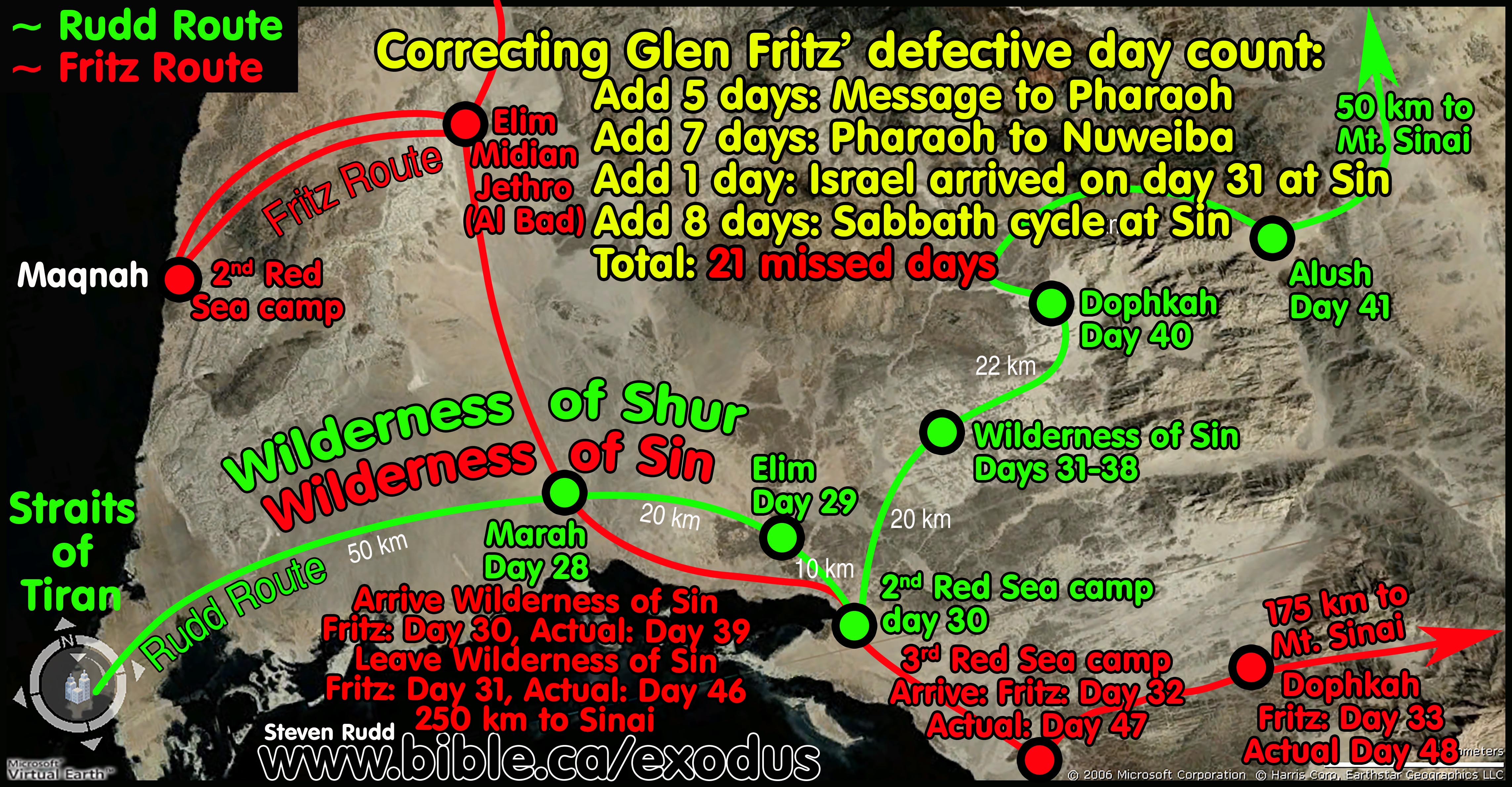
a. In the graphic above we highlight that Fritz missed 21 days that need to be added to his itinerary. However, because he slows the route down so as not to arrive at Mt. Sinai before day 64, we corrected this by actually speeding up the route. This explains why, for example, Fritz has Moses arrive at Dophkah on day 33 but we corrected it to day 48. If you add 21 missed days to Fritz’s day 33 the sum is day 54. But by increasing the daily rate of travel to keep it in harmony with the Straits of Tiran itinerary, it is actually day 48. This means that between Nuweiba and Dophkah we had Moses make the trip 6 days faster than what Fritz calculated. (day 33 + 21 missed days - 6 days saved by faster travel = day 48)
b. The elephant in the Glen Fritz’s chronological room is that Pharaoh was not triggered to leave Egypt until after day 14 when Israel passed Etham. Fritz knows that if Pharaoh was triggered to chase Israel only after day 14 at Etham, it falsifies his entire master’s thesis because Israel cannot reach the Wilderness of Win by day 31 (Ex 16:1) or Mt. Sinai by day 47 (Ex 19:1).
c. Glen Fritz allowed zero time for the messenger to travel to Egypt and tell Pharaoh Israel was trapped at Etham, or any time camped at the Nuweiba beach waiting for Pharaoh to arrive. Fritz has Pharaoh overtake Israel on day 14 at Etham, at which point he quietly and peacefully walks behind the Hebrews until both reach the Nuweiba beach on day 18. After slowly trailing the Hebrews for 4 days through the Wadi Watir canyons, apparently Pharaoh suddenly decides to attack at Nuweiba, and the protecting angel moves the pillar of cloud to prevent the attack. Israel began crossing the Red Sea the following morning on day 19. In Fritz’s logic, this eliminates the need for a messenger to travel 5 days from Etham to Egypt, and report to Pharaoh that Israel was trapped by the wilderness.
d. Since Pharaoh was triggered to pursue the Israelites after the Etham backtrack on day 17, it would take 5 days for a messenger to ride on horseback and inform Pharaoh Israel was trapped, and another 7 days for Pharaoh to ride his horse-drawn chariot to the Nuweiba beach. Since Moses arrived at Nuweiba on day 18, this means that Israel camped at the Nuweiba beach for 11 days (5 + 7 - 1 = 11 days) waiting for Pharaoh to arrive on day 29 (18 + 5 + 7 - 1 = Day 29). Israel then crossed the Red Sea on day 30. Fritz’s errors and omissions add up to 11 missing days (29 - 18 = 11 days) before the Red Sea crossing on day 30. Israel must be in the Wilderness of Sin on day 31 (Ex 16:1). FAIL
e. After crossing the Red Sea on day 30, there were 3 travel days through the canyons to reach Marah, 3 travel days through the canyons to reach Elim, 2 travel days through the canyons to the 2nd Red Sea camp at Maqnah and back to Elim, and 1 easy travel day to finally reach the Wilderness of Sin on day 39 (30 + 3 + 3 + 2 + 1 = 39). Of course, the canyon travel means that there is a 60 km long convoy trailing behind the first to reach the Wilderness of Sin and the last of the Hebrews would not arrive at the Wilderness of Sin until day 41. Scripture says the entire congregation arrived at the Wilderness of Sin on day 31 (Ex 16:1). FAIL
f. Contra Fritz, the 3 million Hebrews arrived at the Wilderness of Sin on day 39, camped 8 nights and left on day 46. We are certain that Israel arrived and left as a single group at the Wilderness of Sin (Ex 16:1 + 17:1). We are certain that Israel camped 8 days in the Wilderness of Sin because Exodus 17:1 tells us Israel did not leave until after six days of manna and the first sabbath day. The Wilderness of Sin was where the entire congregation learned at the same time and in the same place, about the Sabbath/Manna cycle before moving to Dophkah. The Fritz route has so much canyon travel that less than half of the Hebrew population arrived, camped overnight and left the next morning before the rest of the 3 million Hebrews reached the Wilderness of Sin. Fritz allowed for only one camp night and completely missed the 8-day camp at the Wilderness of Sin. FAIL
g. Contra Fritz, Moses left the Wilderness of Sin on day 46 and arrived two days later at Fritz’s unbiblical 3rd Red Sea camp on day 47. It is one travel day for Moses to reach the beginning of the canyon travel at Dophkah, 3 days canyon travel to Alush, 1 camp day for the 2nd Sabbath, 1 day from Alush to Rephidim, 5 camp days at Rephidim, 3 days to Fritz’s Wilderness of Sinai and two days to finally reach the foot of Mt. Sinai n day 64. Ex 19:1 says Israel is at Mt. Sinai on day 47. FAIL
h. We agree with Glen Fritz that the Nuweiba route from Goshen to Mt. Sinai takes 64 days. Ex 19:1 says Moses arrived at Mt. Sinai on day 47. FAIL Even when Fritz misinterprets Ex 19:1 to be a 61-day journey from Goshen to Mt. Sinai, his route is so long that he has Israel arriving on day 64. Fritz has Moses reaching Mt. Sinai 3 days after day 61. FAIL
18. The difficult Nuweiba intersects and merges with the easy Tiran route south of Midian:
a. Fritz’s Nuweiba route merges with the Rudd Tiran route, south of Midian (Al Bad). The two routes directly intersect at Marah (Rudd) and Fritz’s misplaced location for the Wilderness of Sin. After this, the two routes are essentially identical until after the second Red Sea camp (Rudd), which is the same location for Fritz’s unbiblical third Red Sea camp. The Fritz Nuweiba route claims to arrive on day 30 at the Wilderness of Sin, but Ex 16:1 is actually says it is 31 days in a standard Hebrew lunar calendar of 30 days (Nisan 15 to Lyar 15). Fritz has Israel arriving on day 30 (uncorrected Fritz date) at the Wilderness of Sin at the same location as Rudd’s Marah on day 28. Fritz then has Israel leaving the Wilderness of Sin the next morning (day 31) completely ignoring the 8-day camp to learn the Manna/Sabbath cycle (Ex 16:22-26 + 17:1).
b. Overall, the Tiran route is much shorter in distance and time and has much easier terrain than the Nuweiba Route. Nuweiba is 25% longer in distance, 18 days longer (not including 24 missed camp days) and 400% more difficult than the Tiran route.
c. If the Tiran and Nuweiba routes merge and intersect south of Al Bad, why don’t those who promote the more difficult Nuweiba crossing adopt the simpler Tiran crossing route?
|
Summary comparison of Tiran vs. Nuweiba Red Sea Crossings |
||
|
|
Tiran: Rudd |
Nuweiba: Fritz uncorrected |
|
Total days Goshen to Sinai |
47 days (including 8 days waiting for Pharaoh and 8 days at the Wilderness of Sin, 5 days at Rephidim) |
64 days with zero days waiting for Pharaoh, only 1 day at the Wilderness of Sin. Fritz says 61 days to the Wilderness of Sinai and 2-3 more to Mt. Sinai. |
|
Goshen to Red Sea |
294 miles/490 km |
272 miles/ 436 km |
|
Red Sea Crossing |
10 miles/16 km |
10 miles/16 km |
|
Red Sea to Sinai |
120 miles/200 km |
273 miles/ 436 km |
|
Goshen to Sinai |
420 miles/700 km |
555 miles/888 km |
|
Total narrow canyon travel |
18 miles/23 km |
171 miles/273 km |
|
% of narrow canyon travel |
3% (23/700 km) |
31% (273/888 km) |
|
% distance difference |
Nuweiba is 25% longer in distance than Tiran (700/888 km) |
|
III. REJECTED: Red Sea crossing locations:
A. REJECTED: Ezion Geber, Elat Red Sea crossing: (Sir Colin John Humphreys)
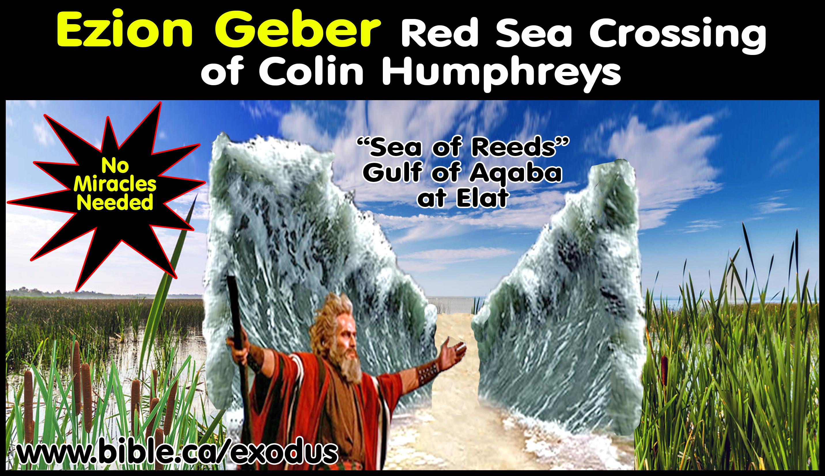
1. Colin Humphreys chose the north end of the Gulf of Aqaba for the Red Sea crossing at Elat and Ezion Geber because of natural freshwater springs near the shoreline. An Elat crossing makes a dead end at Etham combined with a backtrack and then being trapped at Elat impossible. It would be a shallow water crossing and a mini-miracle. It is a naturalistic explanation that downplays the miraculous power of God. The crossing has Israel pass directly through Ezion Geber, which is listed twice in the itinerary of Moses. Ezion Geber is the last stop before reaching Kadesh Barnea from Mt. Sinai in 1444 BC and the first stop after leaving Kadesh in the conquest year of 1447 BC. If the Red Sea crossing was at Elat or Ezion Geber, Moses would have told us he visited the site three times.
2. Humphreys wrote:
a. “So why does the Old Testament use the term yam suph, which undoubtedly means “Sea of Reeds”, to describe the Gulf of Aqaba, which, because of its saltiness, is inherently reed free? I believe the answer to the above question lies in the unusual geography of the head of the Gulf of Aqaba. The Czech explorer Alois Musil, in The Northern Hegaz, written in 1926, describes an extremely unusual feature of the northern seashore at the head of the Gulf of Aqaba: it contains fresh water. He writes: “At low tide the rocky shore was laid bare for a distance of about two hundred yards, uncovering numerous springs which gushed forth with great strength.” Musil then emphasizes the excellent quality of this fresh water: “The animals [camels] did not wish to drink from the fresh water from the well, preferring to go to the sea shore where they very readily drank from the many springs which flowed there.” What is the origin of the water in these freshwater springs at the head of the Gulf of Aqaba? It comes from rain water falling on the mountains bordering the Arabah. The water is then funneled along and under the sand of the Arabah down towards the Gulf of Aqaba, where it breaks out on the seashore as freshwater springs. The head of the Gulf of Aqaba thus has an extremely unusual physical geography. The seashore is a boundary between the salt waters of the gulf to the south and the freshwater coming down to the seashore from the north. In addition, Edward Robinson (Biblical Researches in Palestine, 1841) describes a marsh at the head of the Gulf of Aqaba when he visited it in 1838, which would have been a freshwater marsh fed by freshwater funneled down the Arabah. This marsh still exists today, and reeds grow in it today, as they do in other places around the head of the Gulf of Aqaba (Humphreys, The Miracles of Exodus, 2003). I suggest that when ancient travelers found freshwater springs and reeds at the head of the Gulf of Aqaba, they would have recognized this juxtaposition as extremely unusual. In fact, it was so unusual that they called the place yam suph, the Sea of Reeds. … If my arguments are accepted, the Hebrew Old Testament, the Greek Septuagint, and the New Testament all agree that the crossing of Moses and the Israelites occurred at the Hebrew yam suph, meaning Sea of Reeds, which was later called in Greek erythra thalassa, meaning Red Sea, both terms referring to the Gulf of Aqaba and probably also to the Gulf of Suez and the main body of the Red Sea.” (In My View the Biblical Sea of Reeds is the Red Sea, Colin Humphreys, 2011 AD)
3. Edward Robinson comments in 1841 AD:
a. “The slope back of the castle is cut up with gullies from mountain-torrents; without however presenting any large and distinct water-course. Wady el-Ithm enters the 'Arabah further North on the same side; and I was disappointed in not finding anywhere in the latter valley, more traces of the waters which must rush into it during the rainy season. Indeed, very little water would seem to flow along it into the Gulf; the greater part being probably absorbed by the sand. On the shore I tried the experiment which both Ruppell and Laborde mention, of obtaining fresh water by digging holes in the sand when the tide is out. It was in part successful; though less so than I had been led to expect from their accounts. On digging a hole with the hands, it gradually filled with water, which at first was salt; but when this was removed, the hole again became slowly filled with fresh water. The Arabs had dug several larger holes just by, in which fresh water was standing.” (Biblical researches in Palestine, Edward Robinson, v1, p247, 1841 AD)
B. REJECTED: Sirbonis Lake:
Routes that travel north or east contradict the Bible. They did not take the direct eastern route called "the way of the land of the Philistines", (Ex 13:17-18) which was also known as the Way of Horus", where Egypt had a series of defensive outposts filled with garrisons of soldiers dotted along this route. This rules out any crossing points on the Mediterranean sea, including "Lake Sirbonis" or "Lake Menzaleh". Denies the miracle: Chosen because wind can create a natural land bridge, therefore requires no miracle.
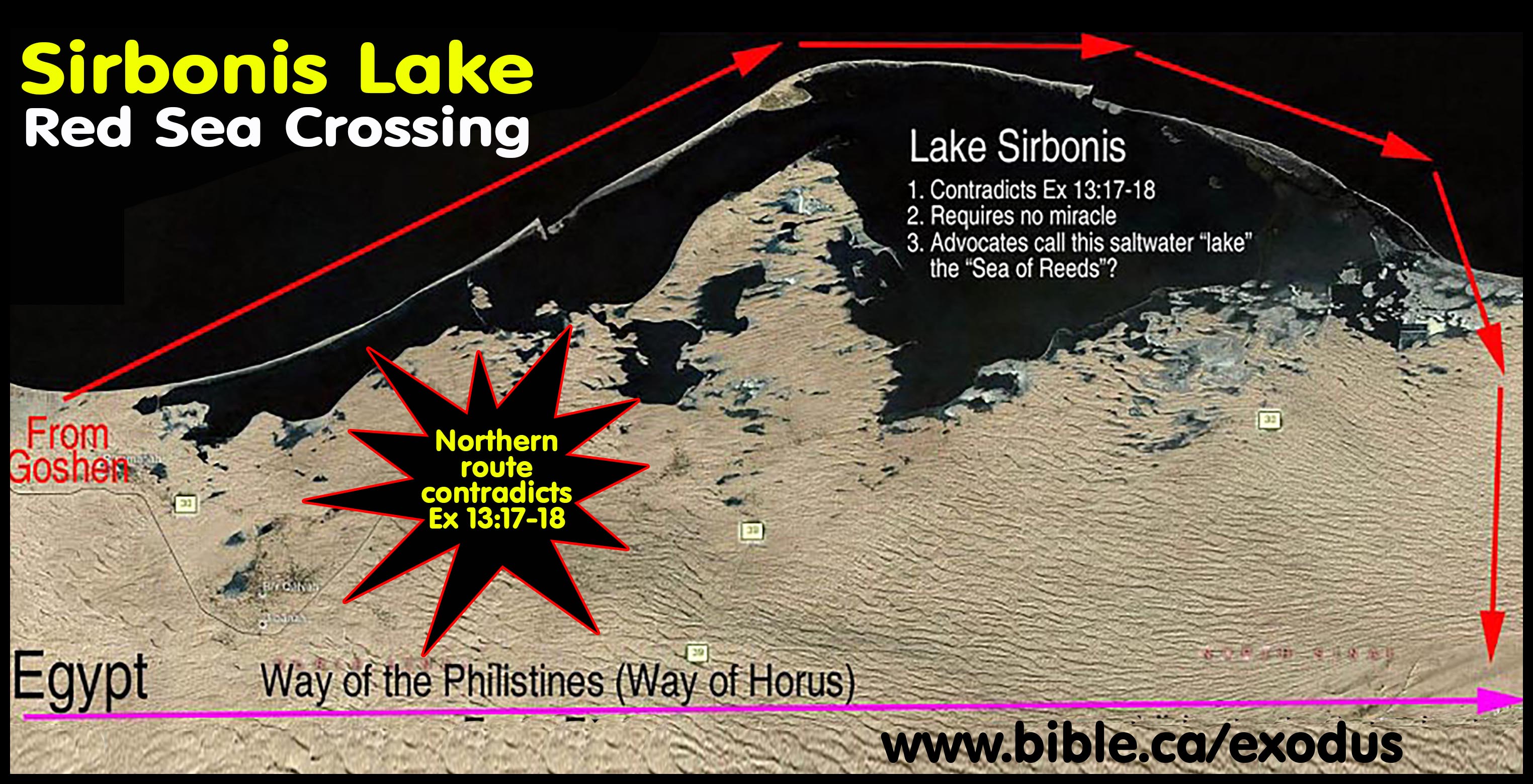
C. REJECTED: Menzaleh Lake, Tanis Lake (Carl Drews)
Carl Drews is not the only one to propose lake Menzaleh, also known as Tanis lake, as the Red Sea crossing. Drews takes a naturalistic approach to explain how winds and tides parted the waters revealing a shallow natural underwater land bridge. Menzaleh lake must be rejected because it violates God’s instructions to not head north or west to the lands of the Philistines: Ex 13:17-18.
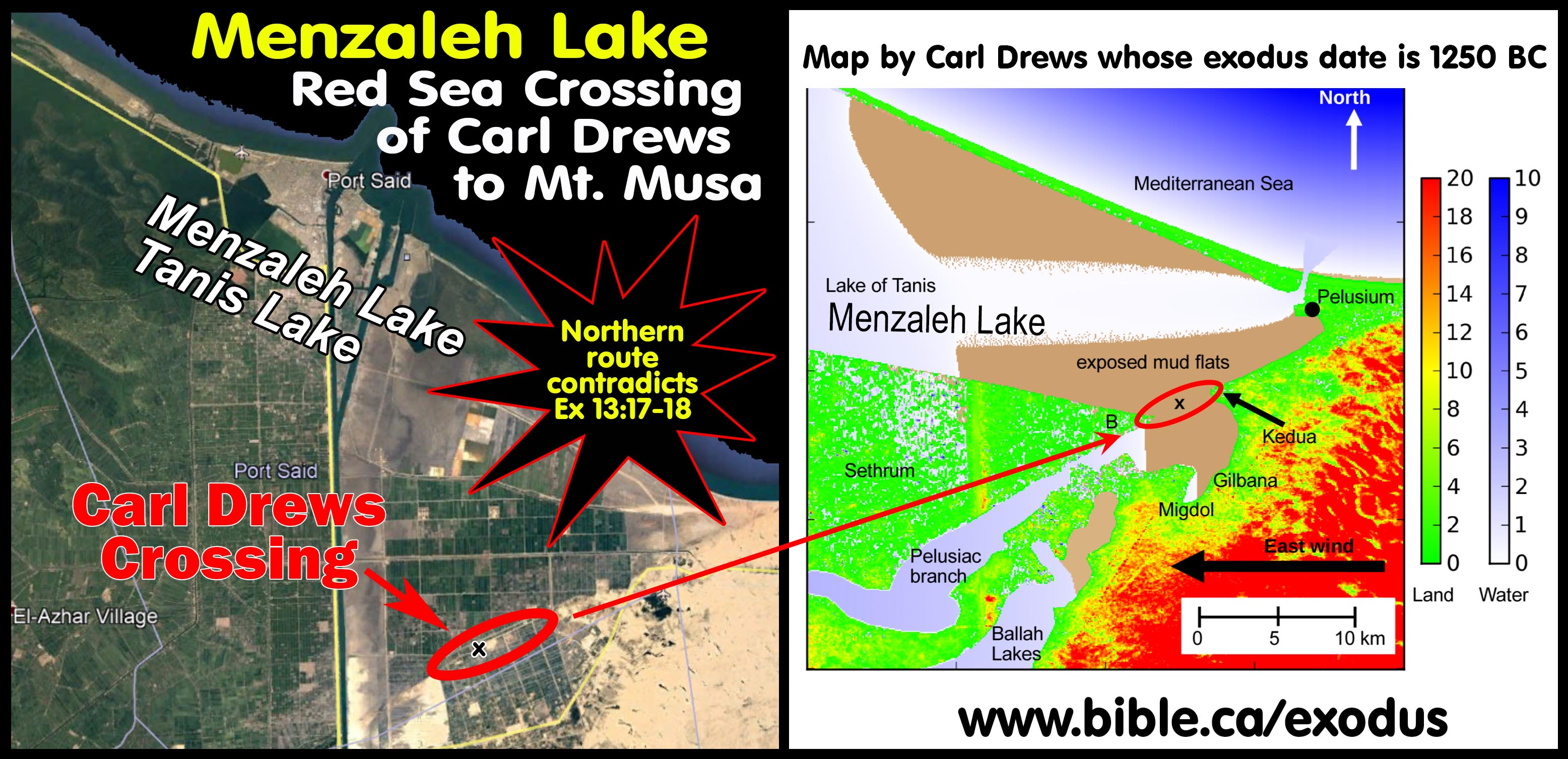
D. REJECTED: Port of North Gulf of Suez
The 1856 AD relief map below shows the direction of the natural underwater land bridge. At the crossing point, they are 25 km from the port of Suez. After crossing they are only 4 km from the port. The Egyptian soldiers would not bother following them into the sea. Instead they would sit comfortably in their beach chairs in the sun and wait for Israel to come closer to them. The pillar of Fire between Israel and the army would put the army at the Port of Suez, which is the exit point of the crossing! Etham doesn't fit because there is no dead end and no way to be trapped at the Red Sea. There are mountains on the west side of the proposed crossing point but they never get any narrower than 800 meters which provides a huge escape path. After crossing past this 800-meter bottleneck, the terrain opens up to a huge flat plain.
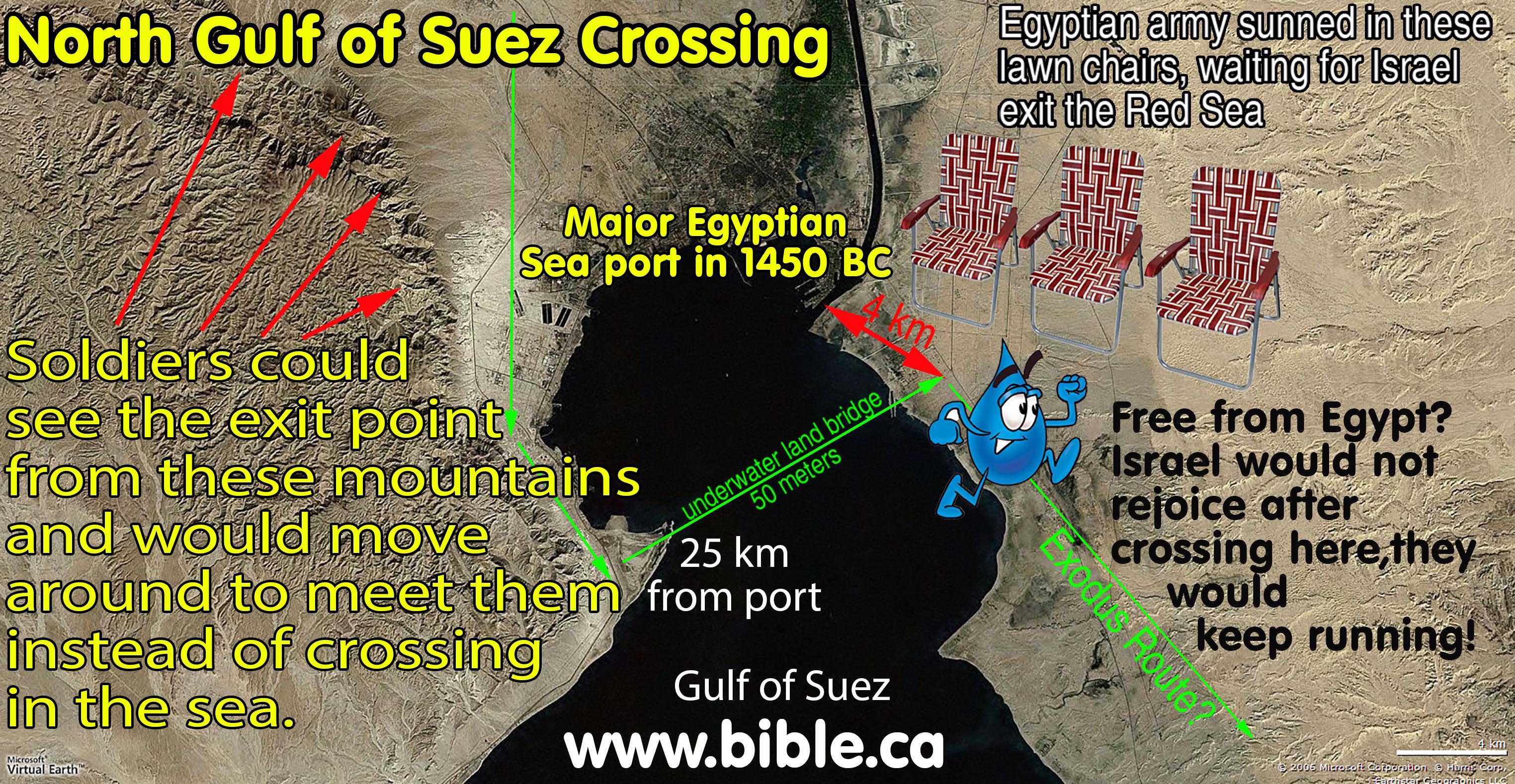
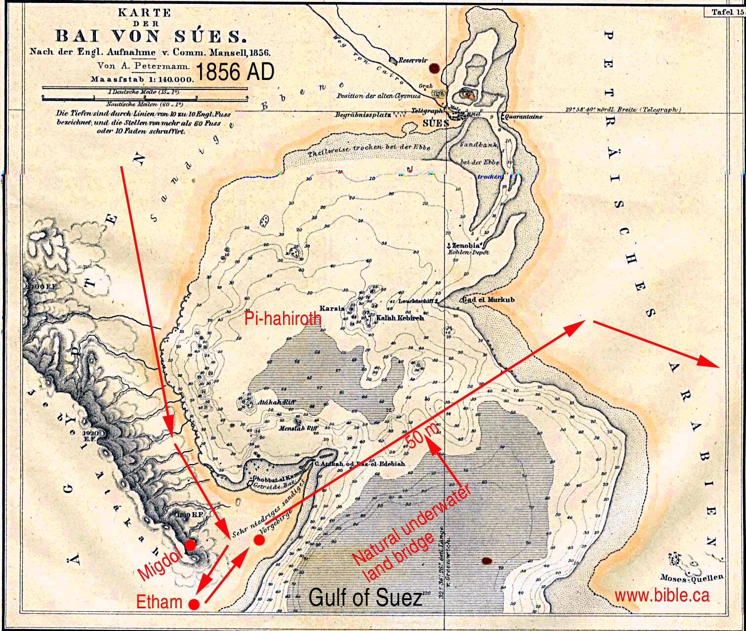
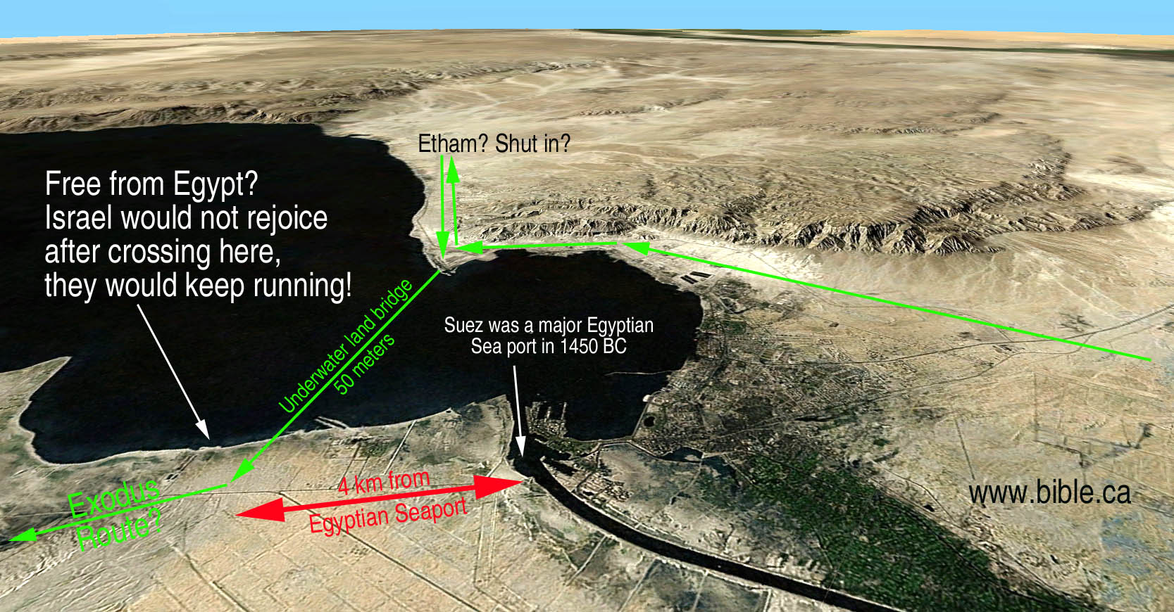
E. REJECTED: El-Ballah Lakes (James Hoffmeier, Bryant Wood, David Rohl)
Ballah Lake must be rejected because it contradicts Ex 13:17-18. Israel was forbidden to take a north or eastern route towards "the way of the land of the Philistines". It is impossible to be trapped and the shallow freshwater “sea of reeds” downplays the miraculous. The Ballah lakes were also fully inside the land of Goshen, and were used regularly by the Hebrews as an important water and food source for themselves and their herds. The Ballah lakes are so close to Goshen, Israel would reach the “Red Sea” the same day they departed Goshen. The Ballah lakes are too close to Egypt to provide assurances that Israel was safe after crossing. Instead of rejoicing, they would keep running. The Ballah lakes are closer to Egypt and very near the Way of the Philistines, so that when “Israel saw war”, they would just walk home in a few hours.
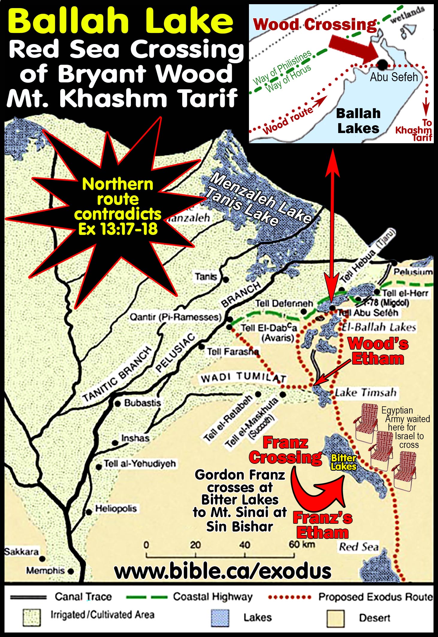
F. REJECTED: Timsah Lake (William Schlegel, Barry Beitzel)
Timsah lake suffers from all the same shortfalls as Ballah lake. We know today that Goshen was historically centered at Wadi Tumilat and the Hebrews occupied the ancient “Lake Goshen” that was less than 10 km from Lake Timsah. Goshen lake, located in the Wadi Tumilat and Lake Timsah on the eastern edge of Goshen, would have been heavily utilized by the Hebrews for food and water supplies. It is likely that in ancient times the entire shoreline of lake Timsah was fully occupied by Hebrews as part of the land of Goshen. There is no way to be trapped and the Egyptians would just sit in lawn chairs sipping a cold drink, waiting for the Hebrews to exit the other side of the Red Sea crossing.
G. REJECTED: Bitter Lakes (Gordon Franz)
The Bitter lakes suffer from all the same shortfalls as Ballah and Timsah lakes. It was only 15 km from Goshen, which means it was likely the Hebrew’s weekend vacation fishing resort on their days off from brickmaking. It is too close to Egypt to prevent them from just walking home. It is impossible to be trapped.

II. Rejected candidates for Mt. Sinai:
A. REJECTED: Traditional Mt. Musa
Although Mt. Musa, the traditional location for Mt. Sinai beside Saint Catherine's monastery located in the traditional Sinai Peninsula, cannot be excluded out of hand, there are other reasons for excluding it. It is well documented that most of Queen Helen’s choices were wrong. Since the Roman Catholic and Orthodox churches have both declared by edict, that Mt. Musa is Mt. Sinai, they have a great negative incentive not to question this choice. To do so, would call into question their foundation of tradition being wrong. No archeology from the time of the exodus (1446 BC) has been found connecting the Hebrews with the site.
B. REJECTED: Mt. [Gebel] Khashm et-Tarif
1. Bryant Wood proposes Khashm et-Tarif as Mt. Sinai but there are some serious problems in its relationship with Ezion Geber and his choice of Kadesh Barnea at Ein Qudeirat.
2. The “Ezion-Geber Enigma” for Bryant Wood is:
a. The Red Sea to Mt. Sinai at Khashm et-Tarif: 8 stops to travel 260 km.
b. Mt. Sinai at Khashm et-Tarif to Ezion-geber: 21 stops to travel 30 km through impassable mountains.
c. Ezion Geber to Kadesh Barnea at Qudeirat: 1 stop to travel 140 km through impassable mountains.
d.
Kadesh Barnea at Qudeirat to Ezion Geber: 1 stop to travel 140 km
through impassable mountains.
C. REJECTED: Mt. Karkom rejected for being inside the promised land.
1. The author has summited Mt. Kardom several times and while a fascinating archaeological site, it cannot be Mt. Sinai because it is inside the promised land.
2. Click here for discussion of Mt. Karkom.
III. REJECTED candidates for Kadesh Barnea
- The Petra area is where Kadesh Barnea is located: Using scripture, everyone before 1881 AD located Kadesh Barnea in the Arabah Valley, or near Petra. Eusebius stated that Kadesh and Mt. Hor were at Petra.
- All candidates for Kadesh Barnea that are within the promised land should be immediately rejected. Gen 15:18 sets the boundaries for the promised land between Egypt and Israel at the wadi El-Arish, known also as the "River of Egypt" in scripture. Judah's southern boundary was at the wadi el-Arish: Numbers 34:5; Joshua 15:1-4,47
- REJECTED: Ein el-Qudeirat has been the almost universal choice for Kadesh Barnea since 1916 AD. While Ein el-Qudeirat is outside the modern border of Israel, it is a full 27 km east of wadi el-Arish, the biblical border between Israel and Egypt. It therefore cannot be where Kadesh Barnea is located since this would mean Israel spent 38 years already in the promised land at Kadesh.
- REJECTED: Ein Qedeis was the choice for Kadesh Barnea from 1881 AD to 1916 AD. It is located only 10 miles south of Ein el-Qudeirat. Both should be rejected out of hand on the simple basis that both are within the formal boundaries of the promised land.
- REJECTED: Central Judean Negev (Glen Fritz). Kadesh is located inside the tribal territory of Simeon and Judah, 32 km due west of Ein Hatzeva and 12 km SE of Sde Boker. It is rejected for being inside the promised land. Fritz does not believe the biblical Negev extends much south of Beersheba. He also fails to correctly understand that the southern boundary of Judah extends past the southern tip of the Salt Sea, then extends east, then south past Kadesh at modern Petra. Israel did not spend 38 years inside the promised land.
By Steve Rudd, updated May 2020 AD: Contact the author for comments, input or corrections.