Ein Hasb and Ein El Weibeh:
|
|
1821-1881 AD: The western Arabah Valley |
Introduction:
- "The Identification of the Site Kadesh-barnea's actual site for a long time was subject to scholarly dispute. This is hardly surprising since many of the geographical terms employed in the Bible, including most of those connected with the route of the Exodus, had passed out of currency by late antiquity. Discussion of the site's location, until the 19th century, was based completely on the diverse literary sources. In 1807, however, U. J. Seetzen entered the Negev in the course of his Levantine travels (1854: 1-68), opening this area to modern exploration. At first the search for Kadesh-barnea focused on the Arabah, the deep, desolate geological fissure extending from the south end of the Dead Sea to the Gulf of Aqaba." (Excavations At Kadesh-Barnea: 1976-1978, Ein el-Qudeirat, Rudolph Cohen, 1981 AD)
- In 1806-7 Ulrich Jasper Seetzen, (AKA Musa el Hakim) a Russian Doctor, was first to explore the Negev in recent times but was more of a Muslim pilgrim than an explorer and contributed little to Biblical archeology.
- Archeologists started looking for Kadesh on
the western side of the Arabah valley
where ever they found a natural spring. Two such choices were Ein El
Weibeh and Ein Hasb.
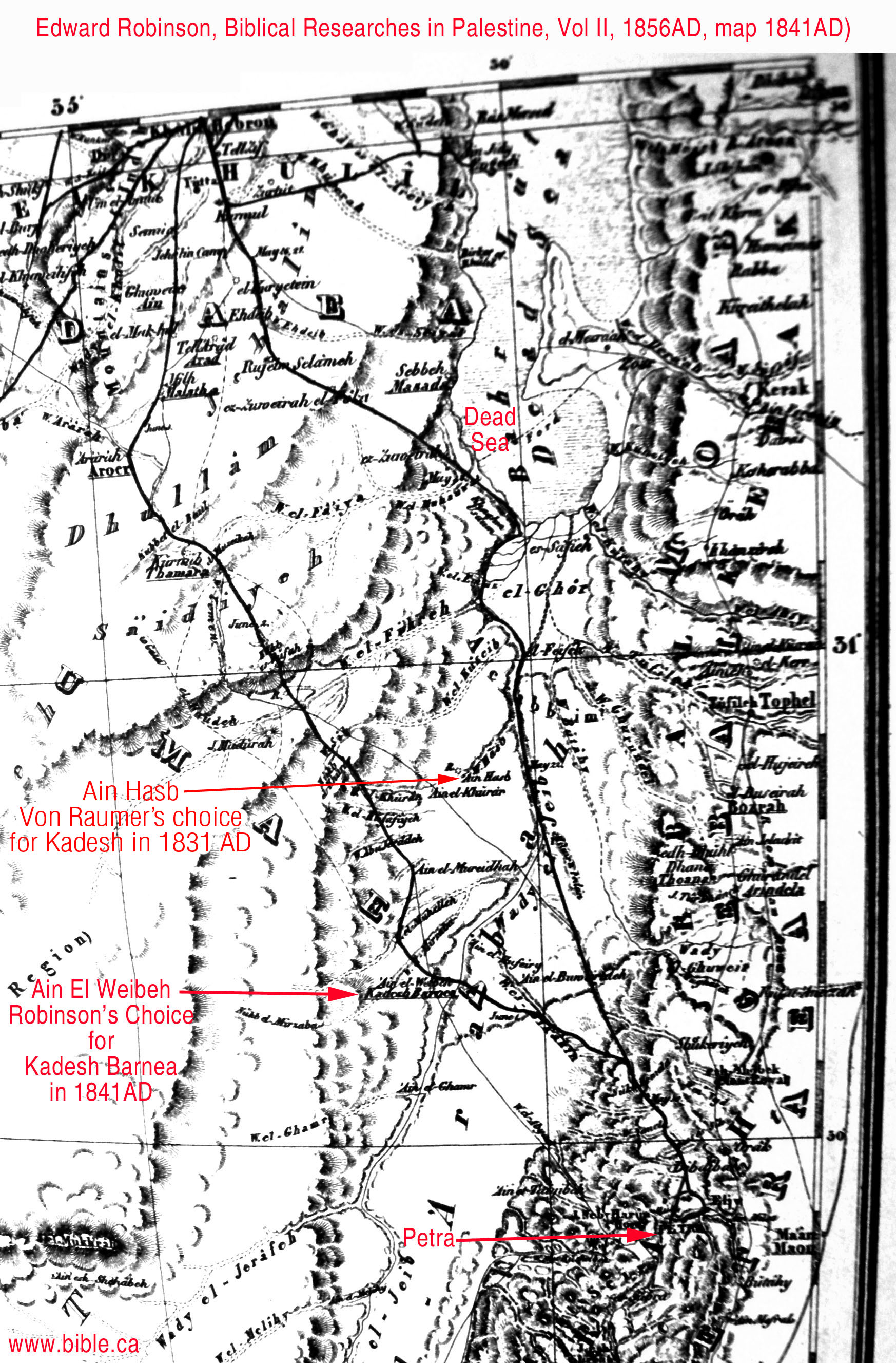
- In 1831, Karl Von Raumer's chose Ein Hasb for Kadesh Barnea: "Another location of the "city," or of the "fountain," of Kadesh, in Burckhardt s Arabah-Kadesh, was made by Karl von Raumer, a German scientist and theologian, who studied and wrote upon the wanderings of the Israelites before he had visited the East, and who again discussed the subject in connection with a record of his travels there. It was in 1836 that he proposed an identification of Kadesh in the upper Arabah. His description of his location was somewhat confused, as he apparently supposed Jebel Madurah to be nearer the Arabah than it is ; but subsequently he settled on Ayn Hasb as the site for his championship. But all that can be said for or against that site is, that if the Israelites were ever up there in the meshes of that Edomitish net, Ayn Hasb would have answered as well as any one of a half dozen spots for Kadesh-barnea. From the days of Burckhardt and Laborde, the records of desert travel have been numerous and intelligent, quite beyond any thing known before that time. Yet, after all, comparatively few travelers have passed up the Arabah into the Holy Land, and fewer still have gone directly northward to Hebron from the lower or central desert." (Kadesh-Barnea Henry Clay Trumbull, 1884 AD)
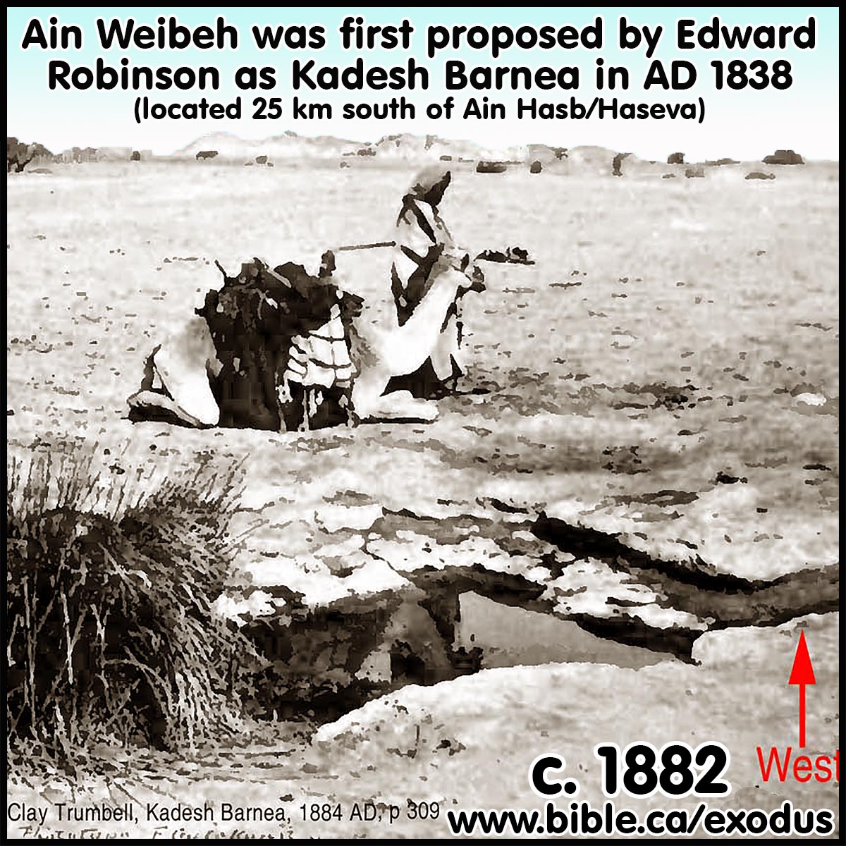
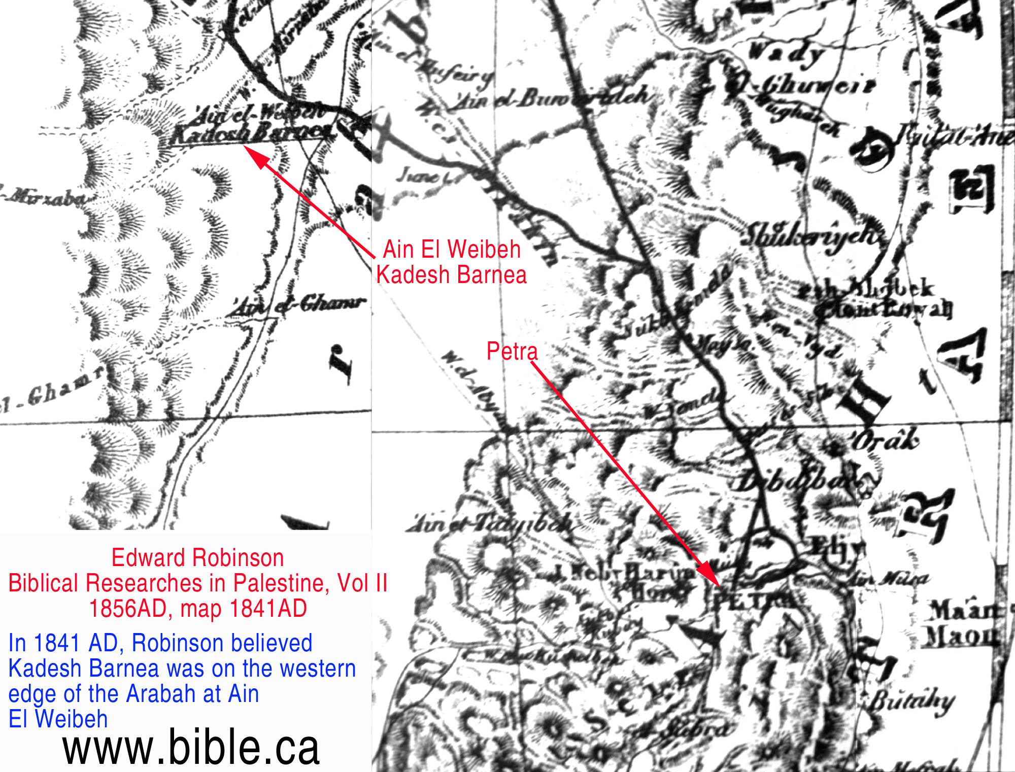
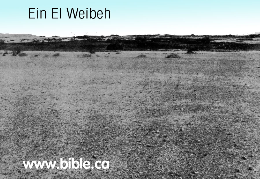
- In 1838 Edward Robinson chose Ein El
Weibeh as Kadesh Barnea just a few km south of Ein Hasb.
- Of course neither of these could be
Kadesh because the western edge of the Arabah valley was the Territory of
Judah. Kadesh Barnea cannot be located Ein Hasb or Ein El Weibeh or Ein el
Qudeirat for the same reason: Kadesh was not located with in the promised
land.
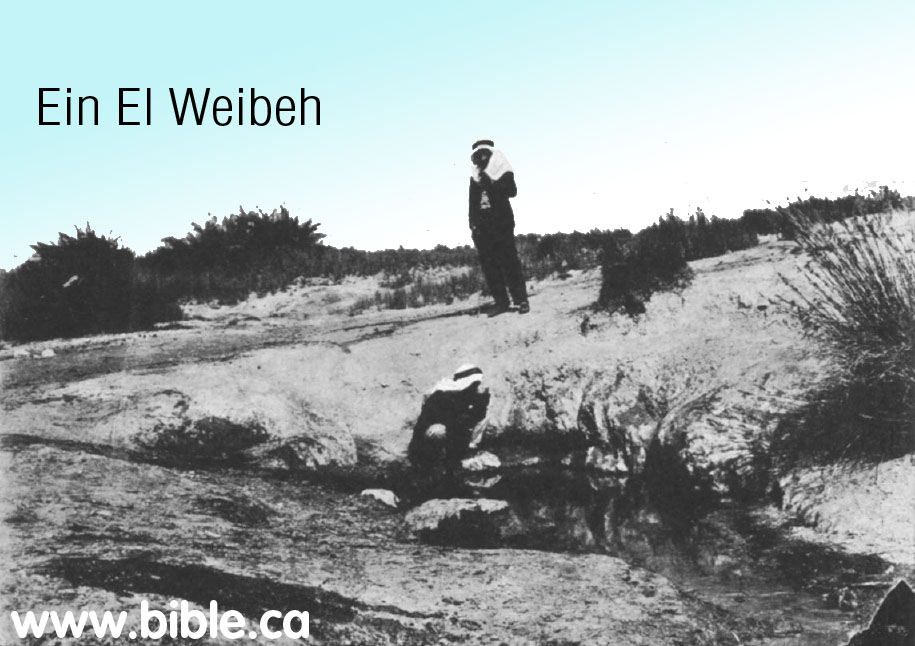
- In 1856, Arthur Penrhyn Stanley rejected Weibeh and stated that Petra was the location of Kadesh. Speaking of Mt. Hor beside Petra Stanley said: "It is one of the very few spots connected with the wanderings of the Israelites, which admits of no reasonable doubt." While he knew nothing of Nabatean history at Petra, his observations are correct. Today we know that the Nabateans arrived in Petra about 350 BC they found a vacant city of Hebrew tombs from the Exodus 1200 years earlier. Remember 2.5 million Jews died here. The Nabateans greatly enhanced the location with the elaborate carvings we see today. Being longstanding enemies of the Hebrews, they removed all traces of the Hebrew past, just like Pharaoh did in Egypt after Israel left Goshen. "If there be any ground for this conclusion, Petra assumes a new interest. Its rock-hewn caves may have served in part for the dwellings, in part for the graves of the Israelites." (Sinai and Palestine, in connection with their history, Arthur Penrhyn Stanley, 1856 AD, p84-99)
- Stanley considered Ein El-Weibeh as a possible location for Kadesh but said Petra was a better choice. "All these indications compel us to look for some more definite locality than can be found in the scattered springs and pools in the midst of the desert, with which travellers have usually endeavoured to identify it- such, for example, as Ein El-Weibeh, on the eastern side of the 'Arabah, which Dr. Robinson selected as the spot, and which, but for the reasons just given, would not be an inappropriate scene." (Sinai and Palestine, in connection with their history, Arthur Penrhyn Stanley, 1856 AD, p84-99)
- Stanley concluded with Petra as his choice for Kadesh: "Is it too much to suppose that this point and Mount Hor were long regarded as the two sacred spots-of Petra ; that the scene of the death and sepulture of Aaron was designedly fixed in view of this, the innermost sanctuary of the Holy Place of " Kadesh ; " that this sanctity was retained through the successive changes of Pagan and Christian worship ; and that the pilgrims of the Desert mounted these time-worn steps, and traced their inscriptions upon the rock, on their way to the only spot, whence they could see the grave of Aaron ? (Sinai and Palestine, in connection with their history, Arthur Penrhyn Stanley, 1856 AD, p84-99)
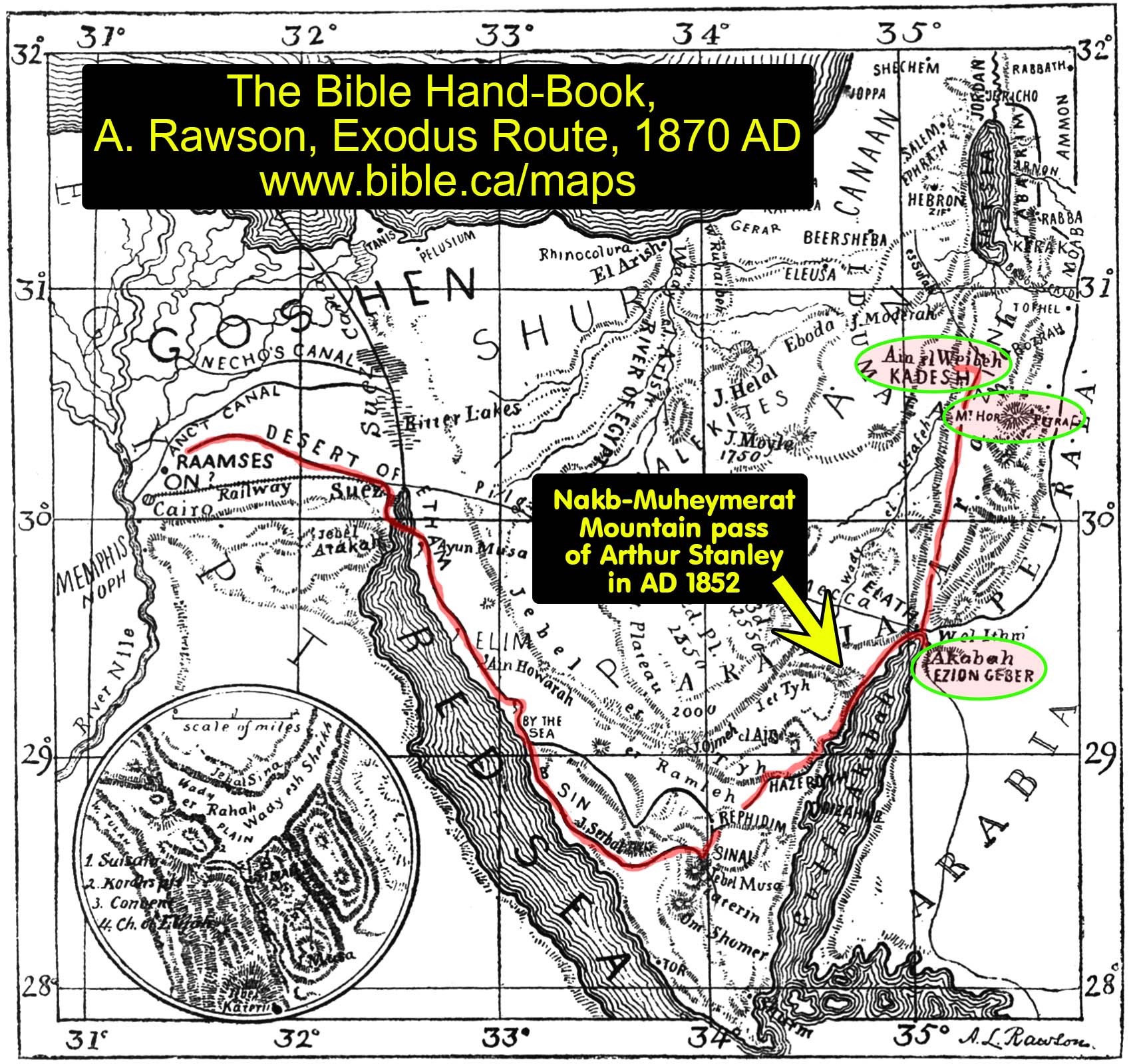
- In 1870 this map represented the thought of the day, that Kadesh was located at Weibeh, from The Bible Handbook, A Rawson:
- Schmidt misrepresents Robinson in saying he thought Ein El-Weibeh was Kadesh, when in fact Stanley had had merely considered Ein El-Weibeh as a candidate, but in the conclusion chose Petra instead as Kadesh. "Edward Robinson, (Biblical Researches, 2 ed, 1856, ii. 175, 194) on his visit to 'Ain el Webeh, June 2,1888, was so strongly impressed with this most important watering place in the Arabah that he identified it with Kadesh Barnes. His description of it was quite accurate. On the assumption that "Mount Seir" and "the land of Edom" had the 'Arabah for its western border, and that all Biblical statements are equally reliable and must at any price be harmonized, he could scarcely reach a different conclusion." (Kadesh Barnea, Nathan Schmidt, Journal of Biblical Literature, Vol 29, no 1, 1910 AD, p68)
- In 1871, Jamieson, Fausset, Brown said:
"they came . . . to Kadesh--an important encampment of the Israelites. But its exact situation is not definitely known, nor is it determined whether it is the same or a different place from Kadesh-barnea. It is supposed to be identical with ein-el-weibeh, a famous spring on the eastern side of the desert [Robinson], or also with Petra [Stanley]." (Commentary Critical and Explanatory on the Whole Bible, Jamieson, Fausset, Brown, 1871 AD, Num 13:26)
"the people abode in Kadesh-supposed to be what is now known as ein-el-weibeh, three springs surrounded by palms." (Commentary Critical and Explanatory on the Whole Bible, Jamieson, Fausset, Brown, 1871 AD, Num 20:1 ) - In 1872, Johann Heinrich Kurtz accepts Ein el Qedeis as Kadesh Barnea. See our comments below regarding Keil and Delitzsch using Kurtz in their commentary of the Bible at Num 12:16: "In October 1842 (according to the account given by Williams in his "Holy City" p. 487 sqq.), the two friends made an excursion beyond Hebron, for the purpose of putting to the test on the very spot, the accounts which still wavered as to the southern boundary of Palestine. They went from Arar (Araran, Aroer) towards the south-west, and ascended from the table-land of Arar, the first mountain rampart, by which it is bounded on the south. They now found themselves upon a still higher plateau, which stretches from east to west, and is called the Wady Rakmah. It answers to the district of the Dhullam and Saidiyeh on Robinson's map. After going still farther south, they ascended a second mountain-range, from the summit of which a scene presented itself to the view of the most magnificent character. (From statements made by Williams elsewhere, the point at which they now stood was somewhere about the longitude of Beersheba, twenty miles to the south of this place, near 31° north latitude, 32.5° longitude. A gigantic mountain towered above them in savage grandeur, with masses of linked rock, resembling the bastions of some Cyclopean architecture, the end of which it was impossible for the eye to reach towards either the west or the east. It extended also a long way towards the south; and with its rugged, broken, and dazzling masses of chalk, which reflected the burning rays of the sun, it looked like an unapproachable furnace, a most fearful desert without the slightest trace of vegetation. A broad defile, called Wady Murreh, ran at the foot of this bulwark towards the east, and after a course of several miles, on reaching the strangely formed mountain of Moddera (Maduran), it divided into two parts, the southern branch still retaining the same name and running eastwards to the Arabah, whilst the other was called Wady Fikreh, and ran in a north-easterly direction to the Dead Sea. " This mountain barrier," says Williams, " proved to us beyond a doubt, that we were now standing on the southern boundary of the promised land." They were confirmed in their opinion by the statement of the guide, that a few hours journey towards the south-west would bring them to Kadesh. As you pass along the ordinary road to Hebron, on the western side of the mountainous district of the Azazimeh, the whole of the mountain-slopes between Jebel Araif and Jebel Khalil (or the heights of Hebron) appear to form a continued and unbroken range. But just as the separation of the mountains of the Amorites from the northern wall of the Azazimat, by the Wady Murreh, is concealed by the link which connects the two together to the east of Eboda; so do the projecting ranges of the western wall of the Azazimat keep out of sight an extended desert plain, which runs for many miles into the heart of the Azazimat on the other side of the Jebel Moyleh, and into which several wadys open from the eastern side of the mountain (e.g. the Wady Kesaimeh, the Wady Muweilih [ Moilahi], and the Wady Eetemat). "In the remote background, surrounded by the wilderness, there stands in a state of remarkable isolation the strong rock with its copious spring, —the spot which still bears the ancient name of Kadesh (Ain Kudés) (1), and of which Rowlands was the discoverer." That this is the wilderness of Kadesh, which plays so important a part in the history of the sojourn of the Israelites, is apparently no longer open to dispute (3). From the peculiar configuration of the soil, we may easily understand why this plain, which has a distinct name of its own (viz., Kadésh), should sometimes be regarded as a part of the desert of Paran (et-Tih), and at other times as belonging to that of Zin (the plain of Murreh) (2)." (History of the old covenant: Johann Heinrich Kurtz,1872 AD, Vol 3, Geological survey, p225-226)
- Between 1872 - 1891 in their commentary on the Bible at Num 12:16, Keil and Delitzsch rejected a transjordan location for Kadesh Barnea on the basis of what Johann Heinrich Kurtz reported in his History of the old covenant: ,1872 AD, Vol 3, Geological survey, p225-226. Keil and Delitzsch said this: "See Kurtz, History of the Old Covenant, vol. iii. p. 225, (History of the old covenant : Johann Heinrich Kurtz,1872, vol, 3 p 225) where the current notion, that Kadesh was situated on the western border of the Arabah, below the Dead Sea, by either Ain Hasb or Ein El Weibeh, is successfully refuted." (Keil and Delitzsch, Num 12:16, footnote) When you read Kurtz's actual evidence that Kadesh Barnea could not be transjordan, this is what Kurtz said: ""This mountain barrier," says Williams, "proved to us beyond a doubt, that we were now standing on the southern boundary of the promised land." They were confirmed in their opinion by the statement of the guide, that a few hours journey towards the south-west would bring them to Kadesh." Kurtz also makes several enormous errors in his account while describing a location of Ein El Weibeh on the western edge of the Arabah Valley. First he thinks Ein El Weibeh is at the same longitude as Beersheba. The intersecting line of the latitude is 30 miles due west of where he is standing. In fact Beersheeba is 40 miles NW of where he is standing. Then he notes the Bedouin says Ein el Qedeis is only 2 hours away, when it is in fact 50 miles away, likely a 3 day journey, knowing the terrain. Exactly why this unknown mountain barrier would have any bearing on locating the southern boundary of the promised land is a mystery, and is purely speculative therefore worthless. The real reason Keil and Delitzsch and Kurtz believe Kadesh cannot be transjordan is because the Bedouin guide told them that Ein el Qedeis preserves the name "Kadesh". This association has since been utterly rejected. Ein el Qedeis was rejected in 1916, in favour of Ein el Qudeirat, located about 6 km NW of Ein el Qedeis. So in the end, the very association of the name in the mind of the Bedouin guide proved absolutely nothing. Keil and Delitzsch relied upon Kurtz's account which was full of errors. This means they have no good reasons why Kadesh Barnea cannot be transjordan even though the reasons sounded convincing at the time. This comedy of errors underscores how little the explorers knew 100 years ago.
- In 1901, George L. Robinson believed Kadesh to be at Ein Qedeis. Robinson noted that in spite of Trumbull's deceptive description of Kades, he and most of the world scholars still viewed Kades as Kadesh Barnea: "It is pretty generally agreed now that Kadesh of Scripture is probably the same as Ein Qedeis, or "Holy Fountain," of the Arabs. This is the opinion of Rowlands, who first identified it; of Ritter and Schultz ; of Palmer and Dr. H. Clay Trumbull; of Guthe also" (Modern Kadesh or Ein Kadis, George L. Robinson, The Biblical World, Vol. 17, No. 5., May, 1901AD)
- "It is pretty generally agreed now that Kadesh of Scripture is probably the same as 'Ein Kadis, or "Holy Fountain," of the Arabs. This is the opinion. of Rowlands, who first identified it; of Ritter and Schultz ; of Palmer and Dr. H. Clay Trumbull ; of Guthe also, who, however, seems never to have visited the desert (Zeitschrift des Paldstina-Vereins, Vol. VIII, pp. 182 ff.); and of many others. The words Kadesh and Kadis are identical in meaning and etymology-a fact which naturally must have great weight in identifying lost sites. Several other names have been proposed as equally probable, but few, if any, explorers have been in a position to make a comparison, not having been able to visit more than one of the rival sites. Among them most notable of all is 'Ein El-Weibeh, advocated by Robinson in his Biblical Researches; but this spring is located too far to the north and east to have been the mustering-ground and rallying-point of the children of Israel on their desert march." (Modern Kadesh or Ein Kadis, George L. Robinson, The Biblical World, Vol. 17, No. 5., May, 1901AD)
A. Ein El Weibeh near ancient Thamara, Ein Hasb near ancient Praesidium
- It is likely that Ein El Weibeh is Thamara on the Madaba map.
- It is likely that Ein Hasb is Praesidium
on the Madaba map.

- In 1910, Schmidt viewed Kadesh as being at Petra and viewed Ein El Weibeh as being the location for Thamara: "Edward Robinson, on his visit to 'Ain el Webeh, June 2, 1838, was so strongly impressed with this most important watering place in the 'Arabah that he identified it with Kadesh Barnea. His description of it was quite accurate. On the assumption that " Mount Seir " and "the land of Edom " had the 'Arabah for its western border, and that all Biblical statements are equally reliable and must at any price be harmonized, he could scarcely reach a different conclusion. When I visited the place in June, 1905, I was particularly impressed with the large number of palm trees and the excellence of the water in one of the springs. The references to Thamara in Ptolemy, the Peutinger Tables, the Notitia, the Onomasticon, the Madaba mosaic, and the recently discovered Beersheba rescript have convinced me that this place is to be looked for at 'Ain el Webeh." (Kadesh Barnea, Nathan Schmidt, 1910 AD)
- In 1910 AD, Nathan Schmidt, after considering Weibeh, Kades and Qudeirat, rejected them all and concluded that Kadesh was in fact at Petra: In choosing the location of Kadesh, Schmidt rejected Qudeirat in favor of Petra in 1910 the same way that Stanley rejected Weibah in favor of Petra in 1856: "It seems to me even more probable that Petra was the original scene of these stories. Here the great Deliverer (Cp. my article "The Jerahmeel Theory and the Historic Importance of the Negeb," Hibbert Journal, vi. 2 January, 1908, pp 339ff.) performed the miracle of piercing the rock and sending the wonderful stream through the Sik, and here his older brother Aaron died on the peak of Mt. Hor. In earlier times the gulf of 'Akabah reached farther north than it does to-day, and a passage from the eastern side over to El Tih may not have been as easy as it is at present. Nomadic tribes pushing northwest from the land of Midian no doubt found their way down into the Negeb through the defiles of Mt. Seir (Jebel Sharra). The Idumaean clans that camped around Moserah and Zin probably brought with them the traditions of their heroes. Their way from Sinai-Horeb to Kadesh Barnea and Mt. Halak is likely to have led them through the Valley of Moses and put the reputed resting-place of Aaron in Petra." (Kadesh Barnea, Nathan Schmidt, Journal of Biblical Literature, Vol 29, no 1, 1910 AD, p75-76)
- In 1917, the Catholic Encyclopedia reported that if Kadesh was not at Ein Qedeis, then Ein El-Weibeh was the only other option. Of course this was wrong, because Qudeirat had already been chosen a year before in 1916. "A good deal of controversy has existed concerning the site of Cades, no less than eighteen places having been proposed. This may now be considered as settled in favour of 'Ain Qadis or Kadis, discovered by J. Rowlands in 1842, fifty miles south of Bersabee. Its only serious rival, 'Ein El-Weibeh, on the western edge of the Arabah, forty-five miles farther east, which was advocated by Robinson and others, is now generally abandoned. 'Ain Qadis ("Holy Well")" (New Advent Catholic Encyclopedia, Cades, 1917AD)
B. Ein El Weibeh access point through Edom to Jericho:
- Since many mistakenly believed that
Kadesh Barnea was located at Ein
Qedeis, they also speculated that Israel crossed through Ein El-Weibeh
to the Arabah into Edomite lands on their transjordan trip north to
Jericho to enter the promised land.
- In about 1880, Keil and Delitzsch presented this idea: The "king's way" is the public high road, which was probably made at the cost of the state, and kept up for the king and his armies to travel upon, and is synonymous with the "sultan-road" (Derb es Sultan) or "emperor road," as the open, broad, old military roads are still called in the East (cf. Robinson, Pal. ii. 340; Seetzen, i. pp. 61, 132, ii. pp. 336, etc.). This military road led, no doubt, as Leake has conjectured (Burckhardt, Syr. pp. 21, 22), through the broad Wady el Ghuweir, which not only forms a direct and easy passage to the level country through the very steep mountains that fall down into the Arabah, but also a convenient road through the land of Edom (Robinson, ii. pp. 552, 583, 610), and is celebrated for its splendid meadows, which are traceable to its many springs (Burckhardt, pp. 688, 689); for the broad Wady Murreh runs from the northern border of the mountain-land of Azazimeh, not only as far as the mountain of Moddera (Madurah), where it is divided, but in its southern half as far as the Arabah (see pp. 689f.). This is very likely the "great route through broad wadys," which the Bedouins who accompanied Rowland assured him "was very good, and led direct to Mount Hor, but with which no European traveller was acquainted" (Ritter's Erdk. xiv. p. 1088). It probably opens into the Arabah at the Wady el Weibeh, opposite to the Wady Ghuweir. (Keil and Delitzsch, Num 20:14-21)
- Since George L. Robinson believed Kadesh to be at Ein Qedeis he believed that Ain Hasb was the access road through which Israel asked permission to cross through to get up to Jericho to enter the promised land: "In Moses' time Bozrah was probably the capital of Edom; Petra was the capital of the Nabatheans a thousand years later. Accordingly, the messengers whom Moses sent from Kadesh to ask permission to cross Edom's territory "by the king's highway" (Num. 20:17), probably wished permission to cross by the road which leads up from Ain Hasb; first, along the valley bed of Wady Dhalal, and then along the crest of a ridge between Wady Dhalal and Wady Buseirah, coming out at a fountain about two miles south of Bozrah known as ' Ain Jelideh. This is a most excellent road. Surely no one who has actually climbed up from the `Arabah to Petra would ever think of that pass as the route by which Moses wished to cross Edom's territory. And in any case, being refused by the king, is it probable that they would deliberately "move into Edom's territory and," as Trumbull remarks, "start a cemetery on one of the most commanding summits of the nation's stronghold" ? (The True Mount Hor, Jebel Maderah. George L. Robinson, The Biblical World, Vol. 31, No. 2., Feb., 1908, p 86-100)
By Steve Rudd: Contact the author for comments, input or corrections.