The Exodus Route: The Succoth Stop
Hebrew miners at Serabit el-Khadim join Moses.
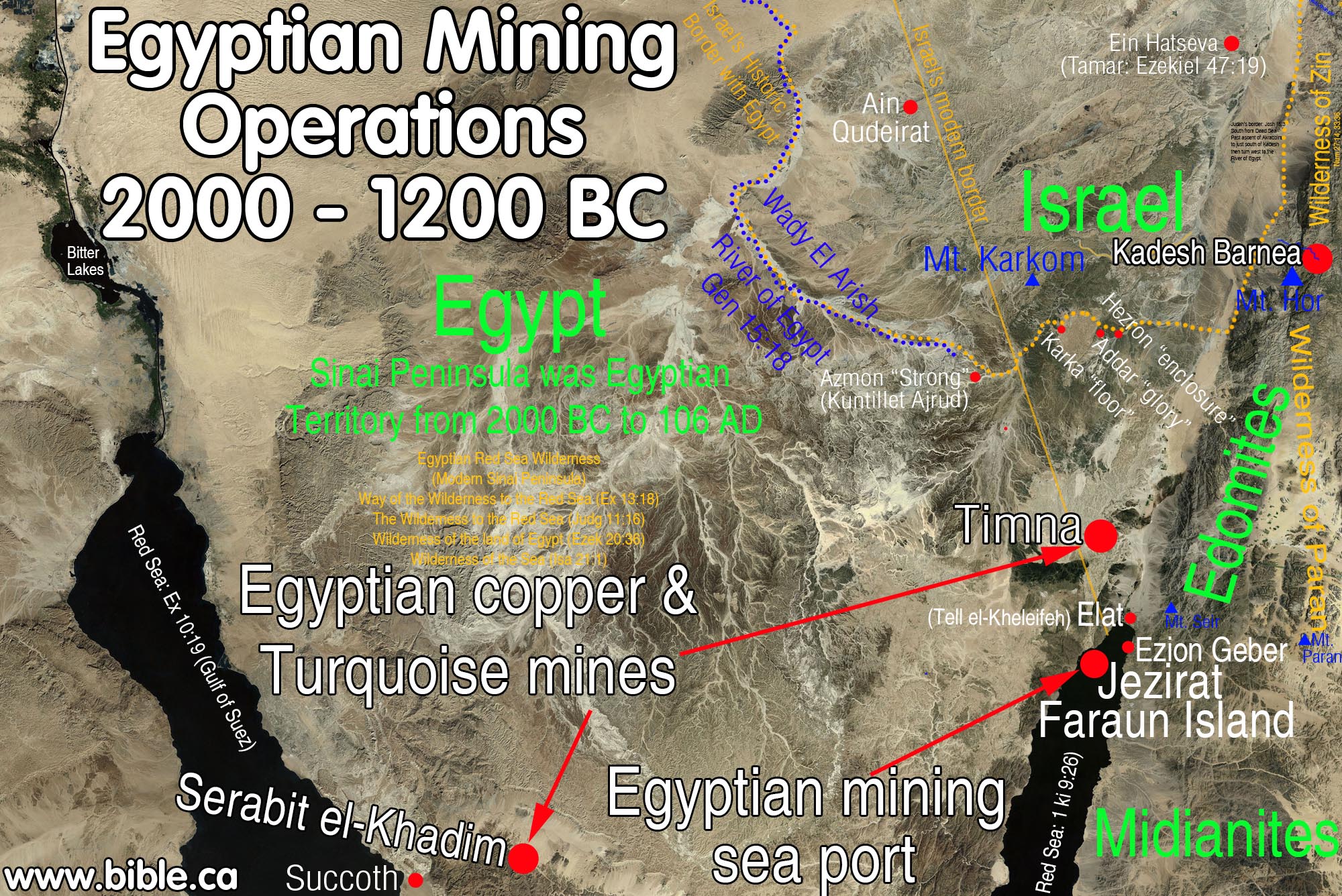
The stop at Succoth was not to rest, it was to collect the Hebrew workers at the Egyptian controlled copper and turquoise mines at Serabit el-Khadim. They travelled day and night by miracle. Two Egyptian copper/turquoise mines were in full operation in 1446 BC in the Sinai.
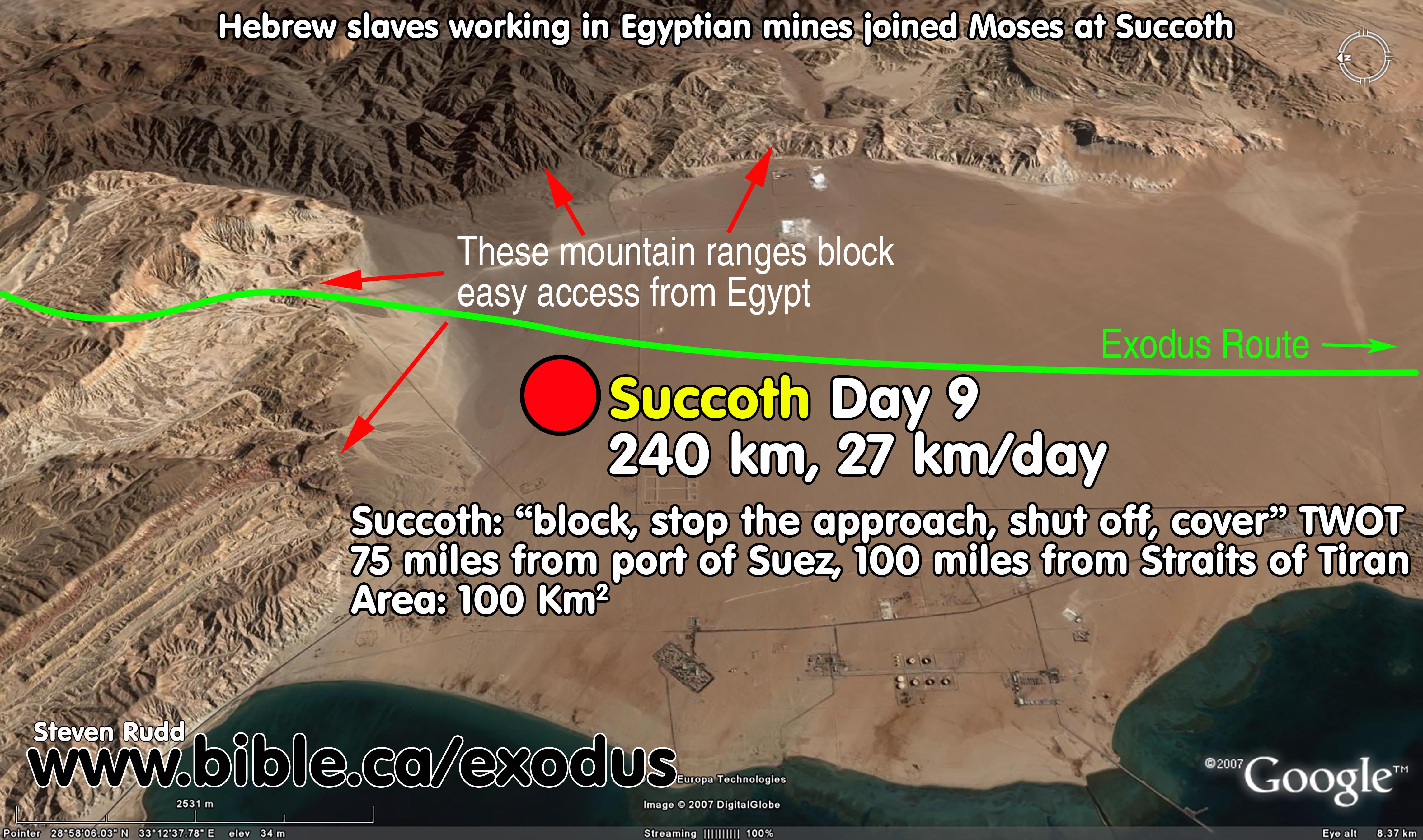
Succoth
"block, stop the approach, shut off, cover" (Theological Workbook Old Testament: 1492 sākak)
|
|
|
|
|

Introduction:
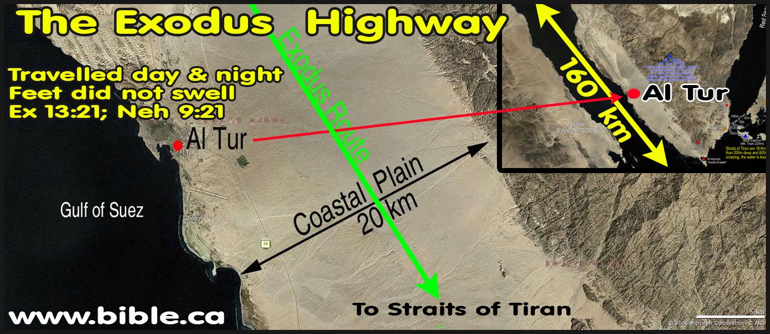
1. Located 120 km south of the Port of Suez, 160 km north of Red sea crossing (Straits of Tiran)
2. We have no idea exactly where Succoth is located, however we can get a clue based upon the name and the proximity of the Egyptian mines.
3. The stop at Succoth was not to rest, it was to collect the Hebrew workers at the Egyptian controlled copper and turquoise mines at Serabit el-Khadim.
4. Today, there is a road that follows the valleys in the mountains between the beach and Bir Nasb. It then continues to Serabit el-Khadim. This route is likely an ancient pathway used by the Hebrews and is only 20 km to Serabit el-Khadim.
See also:
· Miracles of the Exodus and Red Sea Crossing
A. The Succoth Stop: Hebrew miners at Serabit el-Khadim join Moses.
1. The stop at Succoth was not to rest, it was to collect the Hebrew workers at the Egyptian copper and turquoise mines at Serabit el-Khadim.
a.
Two Egyptian
copper/turquoise mines were in full operation in 1446 BC in the Sinai.
2. It is important to understand that Israel travelled day and night without stopping.
a. "The Lord was going before them in a pillar of cloud by day to lead them on the way, and in a pillar of fire by night to give them light, that they might travel by day and by night. He did not take away the pillar of cloud by day, nor the pillar of fire by night, from before the people." Exodus 13:21-22
b. See also: Miracles of the Exodus and Red Sea Crossing
3. They likely stopped for brief food breaks to eat their unleavened bread.
a. "The Egyptians urged the people, to send them out of the land in haste, for they said, “We will all be dead.” So the people took their dough before it was leavened, with their kneading bowls bound up in the clothes on their shoulders." (Exodus 12:33–34)
b. They did not stop to set up tents or sleep.
c. This changes all the “how many miles did they travel in a day” calculations.
d. See also: Travel times, distances, days of the week.
4.
Several of the
recently translated 16 “Sinai Inscriptions” document Hebrew life at Serabit
el-Khadim.

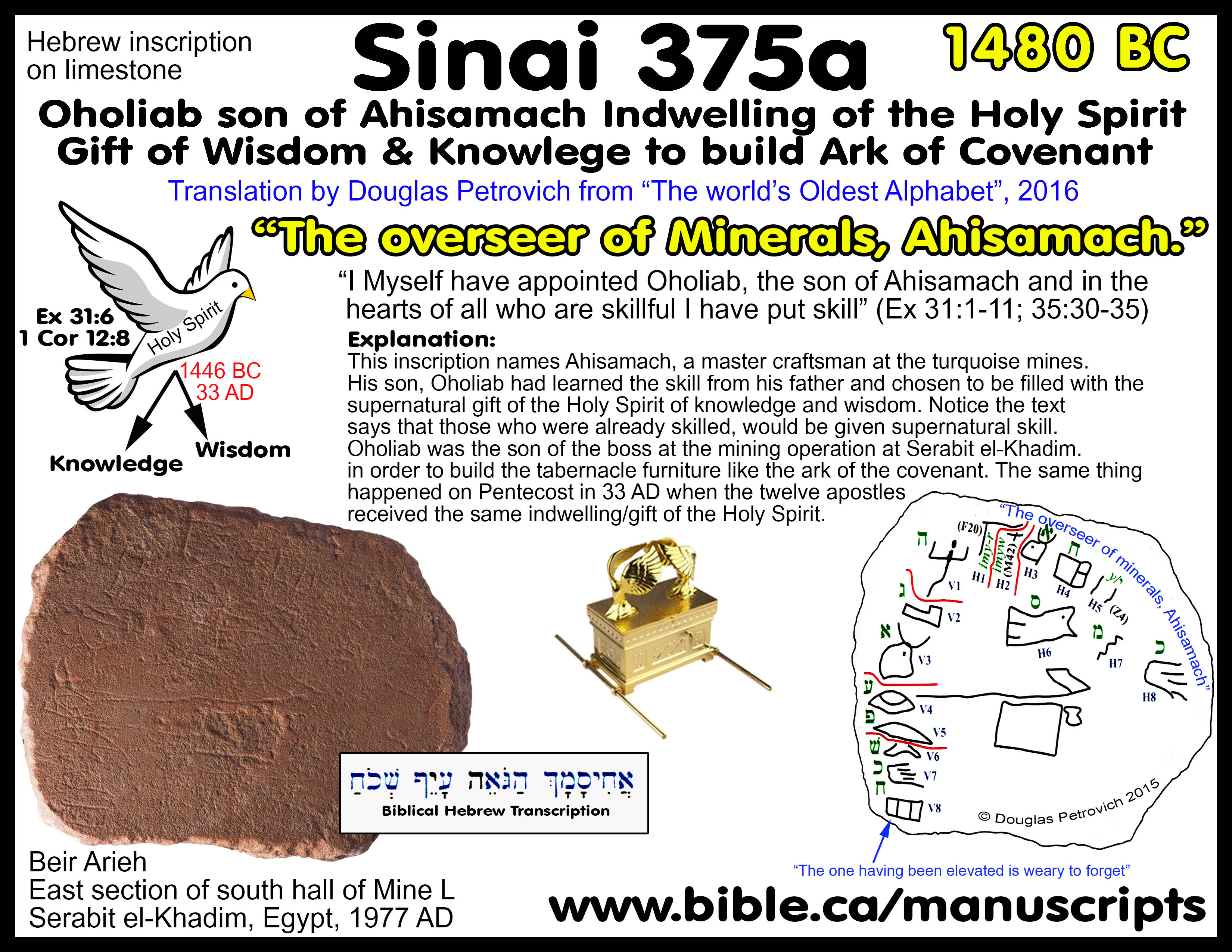
a. Pictured left above is Sinai Inscription #361 (dated to 1446 BC) which translates from Hebrew into English, “Our bound servitude had lingered. Moses then provoked astonishment. It is the year of astonishment because of the Lady [Hathor-the cow goddess]”. See details: Sinai Moses Inscription 361”.
b. Pictured right above is Sinai Inscription #375a (dated to 1480 BC) which translates from Hebrew into English, “The overseer of Minerals, Ahisamach.” This Ahisamach is also named in the bible: Exodus 31:1–11. See details: Sinai Moses Inscription 361”.
c. Sinai inscriptions #115, 345, 349, 353, 357, 360, 361, 375a, were all excavated by Flinders Petrie at Serabit el-Khadim in 1905 AD.
d. The language was unknown and they sat in museums till Douglas Petrovitch recognized them as Hebrew and translated them in 2016 AD.
e. The now famous “Moses Inscription” (Sinai 361) is the first archeological confirmation of Moses ever to be discovered.
f. The inscriptions are proof of a sizable slave population working at the mines.
g. See also: 16 Sinai Inscriptions”.
5. Moses would know about this slave population working at the mine and he would certainly stop to collect the men.
a. These men would have wives and children asking Moses to stop and get their husbands and fathers.
b. Moses could send runners ahead of the main group to instruct them to start packing up and make the short trip.
6. Distances between Succoth and the mines at Serabit el-Khadim
a. Succoth to the mines at Serabit el-Khadim: 20 km over mountains, 40 km around the mountains.
b. Succoth and the mines at Bir Nasb: 12 km over mountains, 25 km around the mountains.
c. This journey is an easy day trip for the slave miners to join Moses camped at Succoth.
B. Bible Texts:
- "Now the sons of Israel journeyed from Rameses to Succoth, about six hundred thousand men on foot, aside from children." Exodus 12:37
- "Then they set out from Succoth and camped in Etham on the edge of the wilderness." Exodus 13:20
- "Then the sons of Israel journeyed from Rameses and camped in Succoth. They journeyed from Succoth and camped in Etham, which is on the edge of the wilderness." Numbers 33:5-6
- There is another town called Succoth in these passages that is not the related to the Exodus route: Genesis 33:17; Joshua 13:27; Judges 8:5-16; 1 Kings 7:46; 2 Kings 17:30; 2 Chronicles 4:17; Psalm 60:6; Psalm 108:7
C. Succoth means: "block, stop the approach, shut off"
- In Hebrew, Succoth means: "block, stop the approach, shut off, cover" (TWOT, 1492)
- Since most of the exodus names were given by the Israelites as they traveled, this name obviously refers to a place that would "block, stop the approach, shut off" easy access by the Egyptian army.
- The 290 km coastal plain on the east side of the Gulf of Suez is flat and wide except for the 16 km section of medium difficulty, hilly terrain. Israel camped on the southern side of these low mountains on the coastal plain that continues to the crossing point. The Hebrews would feel protected from the Egyptians when they stopped here because the difficult terrain to the north would slow down the army.
- This is why they called it Succoth: "block the army, stop the approach of the army, shut off from Egypt"
D. Travel Itinerary, distances and speeds from Goshen to Red Sea:
See also: Travel times, distances, days of the week
|
Itinerary from Goshen to Red Sea Crossing at Tiran |
||||
|
Bible texts |
Day # from Red Sea |
Weekday |
distance from last stop |
|
|
Goshen to Succoth |
Exodus 12:37; 13:20; Numbers 33:5-6 |
1-9 |
Thursday- Friday |
240 km |
|
Etham: 460 km. (Passes Red Sea Camp at 436 km then 24 km to Etham) |
Exodus 14:1-4: 13:20; Numbers 33:6-8 |
10-16 |
Saturday – Friday |
220 km |
|
Red Sea Camp: 484 km |
Exodus 14:1-4 |
17-24 |
Saturday-Saturday |
24 km |
|
Cross Red sea: 500 km |
Exodus 14:13-31 |
25 |
Sunday |
16 km |
|
|
|
|
Total |
500 km |
|
Calculating rates of travel from Goshen to Tiran |
|||||
|
Trip |
Distance |
Total days |
Camp days |
Travel days |
Daily rate of travel |
|
Goshen to Red Sea (including Etham
backtrack and Red Sea crossing) |
500 km |
24 |
7 |
17 |
29 km/day 18 miles/day |
|
Etham backtrack distance from the camp by the Red Sea at the crossing point to Etham and back again (24 km x 2) |
48 km |
- |
- |
- |
- |
|
Red Sea Crossing at Tiran (16 km included in Goshen to Red Sea 500 km) |
16 km |
1 |
- |
1 |
16 km/day 10 miles/day |
|
Red Sea to Sinai |
200 km |
22 |
11 |
11 |
18 km/day 11 miles/day |
|
Goshen to Sinai (including Etham backtrack 44 km and Red Sea crossing 16 km) |
700 km |
47 |
18 |
29 |
24 km/day 14 miles/day |
|
On day 17 when Israel backtracks from Etham, a message from Pharaoh's military "Migdol" to Egypt by homing pigeon at 80 km/hour (average speed is 100 km/hour): "They are moving aimlessly and the wilderness at Etham has shut them in." |
400 km |
5 hours
4 hours |
- |
- |
80 km/hr. 48 miles/hr.
100 km/hr. 62 miles/hr. |
|
On day 18 Pharaoh's army begin pursued Israel with horses and 600 choice chariots (and other standard chariots for a total perhaps of 2000) from Egypt to where the angel stopped them. (Ex 14:6-9) |
400 km |
7 |
0 |
7 |
57 km/day 34 miles/day |
|
Herodotus (450 BC): Mediterranean to Gulf of Suez |
150 km |
4 |
- |
- |
38 km/day |
E. Photos and maps:
Below is the location of Succoth on the southern edge of the mountain range on the coastal flat:
Below is the coastal plain north of Succoth:
Below is the coastal plain south of Succoth at modern Al Tur:
F. How the traditional choice for Succoth fails:
- In the traditional exodus route, Succoth is always placed west of the modern Suez Canal.
- For a crossing at the Bitter lakes, Succoth would be the first stop from Goshen. But since Goshen is only 30 km from the Bitter lakes it is doubtful that such a location could even exist, given the fact that the Israelites may have populated right up to the largest fresh water supply apart from the Nile. There just is not enough space.
- Given the fact that the land is flat and easy to travel, there is no place that could be considered "block, stop the approach, shut off" from Egypt. Any location of Succoth, west of the Suez Canal makes no sense as a place of temporary security form Egypt.
By Steve Rudd: Contact the author for comments, input or corrections.